Transcription
PORT COLUMBUS INTERNATIONAL AIRPORTENVIRONMENTAL IMPACT STATEMENTFINAL5.16 LIGHT EMISSIONSAirports have high-intensity lights to illuminate runways, taxiways, and gate areas,and to supply visual approach navigational aids, which are critical to the safeoperation of an airport.This section presents the analysis of the impact of airport-related light emissionsupon the residential areas surrounding Port Columbus International Airport (CMH orAirport) resulting from the project alternatives under consideration in thisEnvironmental Impact Statement (EIS).15.16.1 REGULATORY SETTINGOnly in unusual circumstances (e.g., when high-intensity strobe lights would shinedirectly into people's homes) would the impact of light emissions be consideredsufficient to warrant special study and a more detailed examination of alternativesin an EIS. Light emissions are assessed to the “extent to which any lightingassociated with an action will create an annoyance among people in the vicinity orinterfere with their normal activities”. Airport facilities at CMH are illuminated byvarious types of lighting emanating from any of the following sources: Airfield lighting on runways, runway thresholds, taxiways, and ramps(runway lighting); Visual approach aids; Obstruction lights; Terminal and facilities lighting; and Roadway and parking lot lighting.Generally, lights located at the runway thresholds and in the approach area posethe greatest concern for potential impact. Therefore, the following light systemswere evaluated:1 Approach lighting system; Visual glideslope indicators; Runway end lights; In-runway lighting; Runway edge lights; and Taxiway edge lights.The light emissions analysis considered only airfield lighting, which would not include lightemissions from restaurants, commercial office buildings, etc.Landrum & BrownMarch 2009Chapter Five – Environmental ConsequencesPage 5.16-1
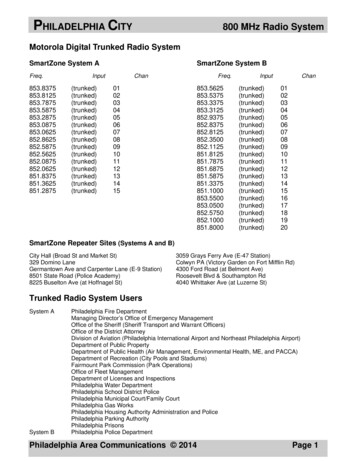
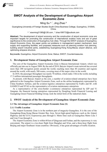
PORT COLUMBUS INTERNATIONAL AIRPORTENVIRONMENTAL IMPACT STATEMENTFINALThe following information is provided in the assessment for each lighting system: Location of existing and future runway threshold lights, and approachlight systems; Descriptions of each airfield lighting system as to its purpose, intensity,color, flashing sequence, and beam angle; and Assessment of the extent of annoyance caused by the CMH airfieldlighting systems.5.16.2 EXISTING CONDITIONS: 2006This section describes conditions at the Airport as they existed during thepreparation of this environmental document. The following paragraphs discuss theexisting lighting systems in use at CMH. A summary of the existing lightingsystems is presented in Table 5.16-1.Approach Lighting Systems (ALS)Approach lighting systems (ALS) provide the basic means to transition frominstrument flight to visual flight for landing. It is a configuration of steady-burningsequenced flashing signal lights that appear to the pilot as a ball of light travelingtoward the runway at high speed (twice a second). Operational requirementsdictate the type and configuration of the approach light system for a particularrunway.All four runway ends include a Medium-intensity Approach Lighting System withRunway Alignment Indicator Lights (MALSR). This system uses medium-intensitylights to guide a pilot to the runway centerline as a flight progresses through thetransition from instrument flight to visual flight during landing. The MALSR lightingsystem provides early runway lineup and lead-in guidance, runway endidentification, and to a degree, roll guidance. The lights are helpful during someperiods of restricted visibility. The MALSR system is beneficial where extraneouslighting prevents the pilot from lining up with the runway centerline or where thesurrounding terrain is devoid of lighting and does not provide the cues necessaryfor proper aircraft attitude control.2 A diagram of a typical MALSR lighting systemis shown in Exhibit 5.16-1, MALSR Lighting System.2Spence, C.F. (Ed). 2006. AIM/FAR Aeronautical Information Manual/Federal Aviation Regulations.McGraw Hill: New York.Landrum & BrownMarch 2009Chapter Five – Environmental ConsequencesPage 5.16-2
PORT COLUMBUS INTERNATIONAL AIRPORTENVIRONMENTAL IMPACT STATEMENTFINALTable 5.16-1EXISTING AIRFIELD LIGHTING SYSTEMSPort Columbus International AirportRunway EndLIGHTING SYSTEM10R28L10L28RMALSRMALSRMALSRMALSRVisual Glideslope IndicatorsPAPInonePAPIPAPIRunway End Identifier LightsnonenonenonenoneIn-Runway LightingnonenonenonenoneRunway Edge LightsHIRLHIRLHIRLHIRLApproach Lighting SystemNotes:MALSR - Medium-intensity Approach Lighting System with Runway Alignment IndicatorLightsPAPI - Precision Approach Path IndicatorHIRL - High Intensity Runway LightsSource:AirNav website, accessed on August 16, 2007. http://www.airnav.com/airport/KCMH.The runway threshold lights start 200 feet from the landing threshold and extend at200-foot intervals into the approach area at a distance of 2,400 to 3,000 feet forprecision instrument runways and 1,400 to 1,500 feet for non-precision instrumentrunways. There are generally seven light bars with five steady-burning lights foreach bar. At the light bar 1,000 feet from the runway threshold, there are twoadditional bars (one on each side of the centerline bar) each with five steadyburning lights.3Runway threshold lights consist of a line of green lights located perpendicular to theextended runway centerline not more than two feet or less than 100 feet from thedesignated threshold of the runway.The lights of the MALSR lighting system are medium-intensity lights with intensitycontrol provided. The lights are white and steady-burning, with green lights closestto the runway threshold. The MALSR lighting system does not use flashing lights.The lights are mounted on poles and aimed with their beam axis parallel to therunway centerline and intercepting an assumed 3-degree slope at a horizontaldistance of 1,600 feet in advance of the light.A MALSR lighting system is installed on Runway ends 10L, 10R, 28L, and 28R atCMH. The MALSR starts at the landing threshold and extends into the approacharea a distance of 2,000 to 2,300 feet, depending on the runway end.Table 5.16-2 shows the nearest homes to each of the MALSR light bars.3FAA AC 150/5340-30B, Design and Installation Details for Airport Visual Aids, August 1, 2006.Landrum & BrownMarch 2009Chapter Five – Environmental ConsequencesPage 5.16-3
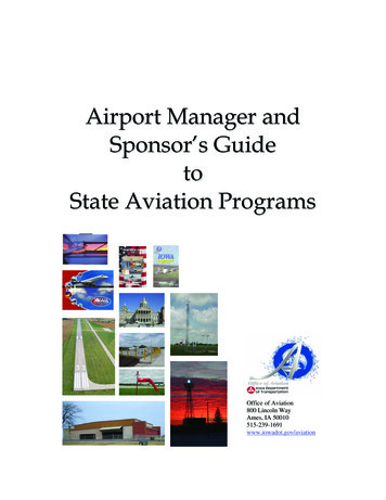
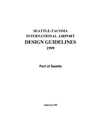
PORT COLUMBUS INTERNATIONAL AIRPORTENVIRONMENTAL IMPACT STATEMENTFINALTable 5.16-2DISTANCES FROM MALSR LIGHTS TO NEAREST HOMES BY RUNWAY END –EXISTING CONDITIONSPort Columbus International AirportSource:RunwayDistance toNearest Home(in feet)10R1,40028L2,60010L1,30028R2,500Landrum & Brown, 2007.Visual Glideslope Indicator: The Visual Glideslope Indicator is a system of lightsarranged to provide visual descent guidance information during the approach to arunway.4 One such system, a Precision Approach Path Indicator (PAPI), provides aspecific light pattern when the aircraft is on the desired descent path to thetouchdown point. A diagram of a PAPI lighting system is shown in Exhibit 5.16-2,PAPI Lighting System.The PAPI system includes four identical light units normally placed 50 feet from theleft side of the runway providing visual approach slope information. The PAPI is asingle horizontal bar with four sharp transition lamps installed on the left side of therunway. The system is located perpendicular to the runway centerline, at adistance from the threshold that provides the proper threshold crossing height andobstacle clearance.Each lamp projects a split beam of light. The upper segment is white, and thelower segment is red. The transition from white to red, or vice versa, occurs withina vertical angle of five minutes of arc at the beam center and results in a welldefined corridor of light consisting of white (top) and red (bottom) beams. Thesesystems have an effective visual range of about five miles during the day and up to20 miles at night.The PAPI lights are high-intensity lights that are red and white and are notsequenced flashing lights. The lights are installed on poles and the light beam ispositioned to project 20 feet above the most critical obstruction in the area.At CMH, PAPI lights are installed at the ends of Runways 10L, 10R, and 28R. Thereis no PAPI at Runway End 28L.4FAA AC 150/5345-52, Generic Visual Glideslope Indicators (GVGI), 9/5/2007.Landrum & BrownMarch 2009Chapter Five – Environmental ConsequencesPage 5.16-4
Runway Landing ThresholdGreen LightsFlashing WhiteLightsWhite LightsEnvironmental Impact StudyPort ColumbusInternational AirportFINAL7/29/08P:\CMH\GIS EIS P150\GRAPHICS\ADMIN DRAFT EIS Document\Working\5.16-1 MALSR.CDRExhibit:MALSR Lighting System5.16-1
THIS PAGE INTENTIONALLY LEFT BLANK
Environmental Impact StudyPort ColumbusInternational AirportFINAL7/29/08P:\CMH\GIS EIS P150\GRAPHICS\ADMIN DRAFT EIS Document\Working\5.16-2 PAPI.CDRExhibit:PAPI Lighting System5.16-2
THIS PAGE INTENTIONALLY LEFT BLANK
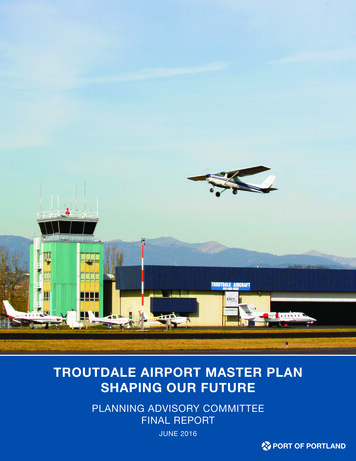
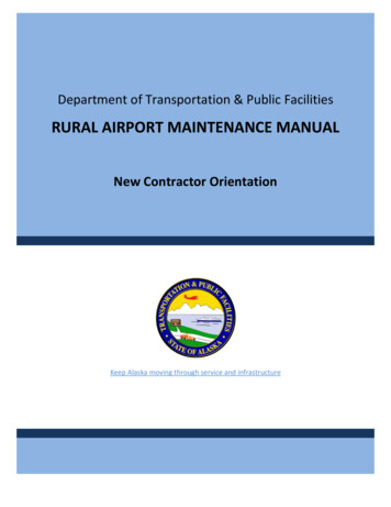
PORT COLUMBUS INTERNATIONAL AIRPORTENVIRONMENTAL IMPACT STATEMENTFINALTable 5.16-3 shows the nearest home to each of the PAPI lighting systems.The lights are projected at such a steep upward angle that the light beam is aboveall surrounding buildings. Residences beyond each of these runway ends would notbe impacted by the light emissions from the PAPI lighting systems at CMH.Exhibits 5.16-3 through 5.16-6 show the lighting equipment installed at each ofthe four runway ends at CMH.Table 5.16-3DISTANCES FROM PAPI TO NEAREST HOMES BY RUNWAY END –EXISTING CONDITIONSPort Columbus International AirportSource:RunwayDistance toNearest Home(in feet)10R2,80028Ln/a10L2,30028R2,300Landrum & Brown, 2007.Runway Edge Light SystemsHIRL are used to outline the edges of a runway during periods of darkness and lowvisibility weather conditions.They are used on runways having precisionInstrument Flight Rules (IFR) approach procedures and for runways utilizingRunway Visual Range (RVR). The lights are located approximately 200 feet apartwith a maximum height of 24 inches above the pavement elevation.The light emitted from HIRLs is white, except that yellow light is substituted forwhite light on the last 2,000 feet of an instrument runway, or one-half the runwaylength, whichever is less. The yellow lights indicate the caution zone for landing.The lights in the caution zone emit yellow light in the direction facing theinstrument approach threshold and white light in the opposite direction.The lights marking the ends of the runway emit red light toward the runway toindicate the end of the runway to a departing aircraft and emit green outward fromthe runway end to indicate the threshold to landing aircraft.5 HIRLs do not usesequenced flashing lights. The yellow and green lights are directed facing theinstrument approach threshold. The white and red lights are directed toward therunway.5FAA AC 150/5340-30B, Design and Installation Details for Airport Visual Aids, August 1, 2006.Landrum & BrownMarch 2009Chapter Five – Environmental ConsequencesPage 5.16-9
PORT COLUMBUS INTERNATIONAL AIRPORTENVIRONMENTAL IMPACT STATEMENTFINALOther Airport LightingA rotating beacon identifies the location of the Airport at night and is identified byprojecting a green and white beam of light 180 degrees apart.Obstructions in the vicinity of the Airport are also marked or lighted to warn pilotsof their presence. These obstructions may be identified by a steady-red, flashingred, or white strobe light. These obstructions are identified for pilots on approachand sectional Visual Flight Rules (VFR) charts and on the official Airport ObstructionChart, published by the National Oceanic and Atmospheric Administration (NOAA).Other lighting exists along the taxiways and ramps for low visibility purposes and toassist aircraft movement on the airfield, such as hold position lights, stop bar lights,and runway and taxiway signage. Each of these additional light systems is locatedwithin the Airport complex and represent no impact upon neighboring communities.5.16.3 FUTURE CONDITIONS: 2012The following section describes the conditions that would result from the lightingrequired by each of the proposed runway alternatives during the first full year inwhich the proposed relocated runway is anticipated to be operational. While thesame types of lighting systems described for the existing conditions are expected tobe used for each of the proposed runway alternatives, the location of lightingequipment in relation to homes will change due to the proposed relocation ofRunway 10R/28L.Alternative A:No ActionUnder this Alternative, Runway 10R/28L would remain in its current location andtherefore no changes to the existing lighting equipment or locations would occur.Alternative C2a:Relocate Runway 10R/28L 800 Feet to the South – Noise AbatementScenario AAlternative C2a includes the relocation of Runway 10R/28L 800 feet to the south.The relocated runway would include MALSR and PAPI lighting on both ends. Theselights would move 800 feet south of the current location. In addition, the relocatedrunway would include a CAT-II approach to Runway 10R, which would increase thenumber of light stands in the MALSR system from 8 to 15. The MALSR lights wouldnot extend farther west than they currently do today; however, the lights would bespaced closer together. Exhibit 5.16-7, Runway 10X (Alternative C2) MALSRand PAPI Locations, and Exhibit 5.16-8, Runway 28X (Alternative C2)MALSR Location, show the location of the proposed lighting equipment forAlternative C2a. Table 5.16-4 and Table 5.16-5 show the distances from theMALSR and PAPI equipment to the nearest homes under this alternative.Landrum & BrownMarch 2009Chapter Five – Environmental ConsequencesPage 5.16-10
" " " " " " "" " "" " " """ "" " """ " " " """ "" "" """ "" "" ""RDLONE SPRUCE"""""""""" """"""""""""""BRIDGE WAY AV"OECOLUNYTRLN"""DRAKE RDe is 1,300'"""" """ """EOLCNOUYTRLNJOHNSTOWNRDClosest residencSTE RLING AV" "ClosestrMA RILYN PARK LNesi deMALSRnceis2,300'PAPI10L"'ST EL ZE R RDLegendSequenced Flashing LightSteady White LightResidenceAirport Property Boundary0SEV ENT EENTHAVEnvironmental Impact StatementPort Columbus International AirportFINAL1/20/2009 Prepared by Landrum & BrownFilename: P:\CMH\GIS EIS P150\MXD\EXHIBITS\EIS\5.16-3 Runway End10L Lighting Equipment.mxdRunway End 10L Lighting Equipment'600 Exhibit:5.16-310
THIS PAGE INTENTIONALLY LEFT BLANK
10RClosest residenceis 1,400'MALSRPAPI"Closest reStelzerCemetery""" """ """"""""""""""""" """"""""""" """ """""" "" """"""""""""""""" """""""""""""" "" ""THIRTEE NTH AVsidence isTW ELF TH AV2,800'STE LZE R RDELE VENTH AVJAESRDSequenced Flashing LightSteady White Light""""THIRTEENTH STSEV ENT H AVOS BORN AVKRUMM AVMLegendFIRST STSOUTH STSECOND STFIFT H STSIXT H STSEV ENT H STEIGHTH STNINT H STTENTH ST"""""""""""""' """""""""""" """" """"""""""""" """""""""""NOR"""" ""TH"ST""""""""""""" """"""""""""""""""""" """""""" """""""""" "" """"""""""""" """"" " "" " " """" """ "ST"" " ""CEN"" "" """" " " " """"" """TER"""""""""""""""" """" "" "" "" """"""" """"""""""""""""""""""""""""""" " "" """""""""""""""""""""""" """"""""""""" """""""""""""""""""""" " "" """ ""SEVE NTH AV" """"STERLING""LN "" """" "" " "" " """""""""""" "AV """ "" " "" " " "SIXTH" """""""""""""EnvironmentalImpact Statement" """ "Port Columbus International" " Airport"""""""""" """ " "" "" """" """ "" "" "ResidenceAirport Property Boundary0FINAL1/20/2009 Prepared by Landrum & BrownFilename: P:\CMH\GIS EIS P150\MXD\EXHIBITS\EIS\5.16-4 Runway End 10RLighting Equipment.mxd600"""Runway End 10R Lighting EquipmentHFIF TAV'FIF TH AV Exhibit:5.16-4
THIS PAGE INTENTIONALLY LEFT BLANK
JAMES RD""" "" "" """" "" " "" """""" "N"OB ERLIN CT"" " "" " " "" " " " "" " " "" " """"""""""""""" " " " "" "" " " " " """""" """""""" """"""""""""""RO"CK"Y FO """RK DR S"" """"" """"""" """""PRICE RD"PRICE RD" "" "" " """ " """" " "" "" " "" DR " " " "NS TO" "HEM" " """ " """HE MS TO"" """N CTB LVRYBUT ERAWD" "MORRIS ON RDARClosest residence is "LegendSequenced Flashing LightSA WY ER RDSteady White LightResidenceYSA WDER REnvironmental Impact StatementPort Columbus International AirportFINAL1/20/2009 Prepared by Landrum & BrownFilename: P:\CMH\GIS EIS P150\MXD\EXHIBITS\EIS\5.16-5 Runway End28R Lighting Equipment.mxdAirport Property BoundaryPetCemetery0600Runway End 28R Lighting Equipment' Exhibit:5.16-5IRJAMES RD502,C"" ""
THIS PAGE INTENTIONALLY LEFT BLANK
RDClosCLAYCRAFTRD28LMORRIS ONMALSRes t res i denc eLE AV IT T SERV ICE RD6is 2,FIF THAV00'BR ICK LAW NAVWE LLINGTO""" """""E RRY LN"DCS BLWIL DBODG WOWINDININLegend"Sequenced Flashing LightSteady White LightWE LLINGTResidenceON WAirport Property BoundaryPALM SPRINGSDR0600OORRISOLD M""WE S'AN RDL ARARO SDRCARDINAL PARK DRAYTA CSA NASA NTICAWOODCLIFF DRW"" """"RunwayEnd 28L LightingEquipment" DR" BEVE"RLY HILLS"" ""ON"MTAPort Columbus International AirportFINAL1/20/2009 Prepared by Landrum & BrownFilename: P:\CMH\GIS EIS P150\MXD\EXHIBITS\EIS\5.16-6 Runway End28L Lighting Equipment.mxdNSAEnvironmental Impact Statement"ME" " "OODS BL" " " ""HION RD"WAYN WILLOWSWMORRISHA MILTON RD'TBOURNE AV Exhibit:5.16-6
THIS PAGE INTENTIONALLY LEFT BLANK
Relocate Runway10R/28L 800 feet South10XClosest residenceis 700'MALSRStelzerCemetery"PAPI"" """ """""""""""""""" """""""""""""""""""" "" """""""""""""""" """"""""""""""""""THIRTEE NTH AVClosest reTW ELF TH AVELE VENTH AVSTE LZE R RDsidence isFIRST STSECOND STFIFT H STSIXT H STEIGHTH STNINT H STESRDLegend""""THIRTEENTH STSequenced Flashing LightSteady White LightResidenceSEV ENT H AVOS BORN AVKRUMM AVTENTH STSEV ENT H STSOUTH STMJA2,000'""""""""""""" """"""""""""""""" "" """ "'""" """"""""" " """""""NOR"""TH""""""ST"""""""" """""""""""""""""""""""""" """"" """""""""""""""""""""""""""" " " " """""""" "CEN""TER"ST"" " """""" """" " """"""""""""""""""""" """ "" "" "" " """ """"""""""""""" "" """"""""" """""""""""" """""""""""""""" "" """""""""" "" " " """""""" """""""""""""""""""""" " "" """ ""SEVE NTH AV" """"""LN "" "" STERLING"" "" " "" " """""""""""SIXTH""AV """ "" " "" " " """"""""""""""" """ """"" " ImpactEnvironmental"""""""""" " "" Statement"" Port Columbus" ""International""Airport" "" "" """"FINAL1/21/2009 Prepared by Landrum & BrownFilename: P:\CMH\GIS EIS P150\MXD\EXHIBITS\EIS\5.16-7 Runway 10X(Alternative C2) MALSR and PAPI Locations.mxdAV0FRunway10X (Alternative C2)MALSR and PAPI LocationsIFHFIF TAirport Property BoundaryVTH A600'FIF TH AV Exhibit:5.16-7
THIS PAGE INTENTIONALLY LEFT BLANK
Relocate Runway10R/28L 800 feet SouthCLAYCRAFTRD28XMALSRCloLE AV ITT SERV ICE RDs est resi dBR ICK LAWNencAVe is00'MORRISON RD2,0HA MILTON RDFIFT H AV'WE LLINGTO"WAYN WILLOWSW""" ""W OOD"HI"MEWAY""" " "LegendOODS BLE RRY LN"DCS BLWIL DBGWINDININ"WE LLINGTON WSequenced Flashing Light"" " "Steady"White Light"CARDINAL PARK DRWOODCLIFF DRRDNILTOMRHA""""'600BEVE RLY HILLS DRA"L AR""TA CSA NARO SICA DFINAL1/20/2009 Prepared by Landrum & BrownFilename: P:\CMH\GIS EIS P150\MXD\EXHIBITS\EIS\Runway 28X(Alternative C2) MALSR Location.mxd0"Airport Property Boundary""Runway 28X (Alternative"C2)SA N GA"BRIE L DR"MALSR Location" " """"""" """"M ONPort Columbus International Airport"ASA NTEnvironmental Impact Statement"ASA NT"ResidencePALM SPRINGSDR Exhibit:5.16-8
THIS PAGE INTENTIONALLY LEFT BLANK
PORT COLUMBUS INTERNATIONAL AIRPORTENVIRONMENTAL IMPACT STATEMENTFINALTable 5.16-4DISTANCES FROM MALSR LIGHTS TO NEAREST HOMES BY RUNWAY END –2012 ALTERNATIVE C2A CONDITIONSPort Columbus International Airport*RunwayDistance toNearest Home(in feet)10X700*28X2,00010L1,30028R2,500Note: This assumes the removal of the 35 homes located on East 13th Avenue, east of SterlingAvenue for the purposes of clearing the Runway Protection Zone. See Section 5.2, Land Use, formore information on acquisition.Source:Landrum & Brown, 2007.Table 5.16-5DISTANCES FROM PAPI LIGHTS TO NEAREST HOMES BY RUNWAY END –2012 ALTERNATIVE C2A CONDITIONSPort Columbus International AirportSource:RunwayDistance toNearest Home(in feet)10X28X10L28R2,000n/a2,3002,300Landrum & Brown, 2007.Alternative C2b: Relocate Runway 10R/28L 800 Feet to the South – NoiseAbatement Scenario BAlternative C2b includes the same relocation of Runway 10R/28L 800 feet to thesouth as Alternative C2a, along with operational changes proposed in the2007 Part 150 Noise Compatibility Study Update (2007 Part 150 Study).The proposed operational changes would not change the number, type, or locationof lights on the airfield. Therefore, the location of runway approach lighting andvisual slope indicators will remain the same as discussed for Alternative C2a andshown on Exhibits 5.16-7 and 5.16-8 and in Tables 5.16-4 and 5.16-5.Landrum & BrownMarch 2009Chapter Five – Environmental ConsequencesPage 5.16-23
PORT COLUMBUS INTERNATIONAL AIRPORTENVIRONMENTAL IMPACT STATEMENTFINALAlternative C3a: Relocate Runway 10R/28L 702 Feet to the South –Noise Abatement Scenario AAlternative C3a includes the relocation of Runway 10R/28L 702 feet to the south.The relocated runway would include MALSR and PAPI lighting on both ends. Theselights would move 702 feet south of the current location. In addition, the relocatedrunway would include a CAT-II approach to Runway 10R, which would increase thenumber of light stands in the MALSR system from 8 to 15. The MALSR lights wouldnot extend farther west than they currently do today; however, the lights would bespaced closer together. Exhibit 5.16-9, Runway 10X (Alternative C3) MALSRand PAPI Locations, and Exhibit 5.16-10, Runway 28X (Alternative C3)MALSR Location, show the location of the proposed lighting equipment forAlternative C3a. Table 5.16-6 and Table 5.16-7 show the distances from theMALSR and PAPI equipment to the nearest homes under this alternative.Table 5.16-6DISTANCES FROM MALSR LIGHTS TO NEAREST HOMES BY RUNWAY END –2012 ALTERNATIVE C3A CONDITIONSPort Columbus International Airport*RunwayDistance toNearest Home(in feet)10X28X10L28R700*2,1001,3002,500Note: This assumes the removal of the 35 homes located on East 13th Avenue, east of SterlingAvenue for the purposes of clearing the Runway Protection Zone. See Section 5.2, Land Use, formore information on acquisition.Source:Landrum & Brown, 2007.Table 5.16-7DISTANCES FROM PAPI LIGHTS TO NEAREST HOMES BY RUNWAY END –2012 ALTERNATIVE C3A CONDITIONSPort Columbus International AirportSource:RunwayDistance toNearest Home(in feet)10X28X10L28R2,100n/a2,3002,300Landrum & Brown, 2007.Landrum & BrownMarch 2009Chapter Five – Environmental ConsequencesPage 5.16-24
Relocate Runway10R/28L 702 feet South10XClosest residenceis 700'MALSRStelzerCemetery"PAPI"" """ """""""""""""""" """""""""""""""""""" "" """""""""""""""" """"""""""""""""""THIRTEE NTH AVClosestTW ELF TH AVESRDLegend""""THIRTEENTH STSequenced Flashing LightSteady White LightResidenceSEV ENT H AVOS BORN AVKRUMM AVMJAFIRST STSOUTH STSECOND STFIFT H STSIXT H STSEV ENT H STEIGHTH STNINT H STTENTH ST""""""""""""" """"""""""""""""" "" """ "'""" """"""""" " """""""NOR"""TH""""""ST"""""""" """""""""""""""""""""""""" """"" """""""""""""""""""""""""""" " " " """""""" "CEN""TER"ST"" " """""" """" " """"""""""""""""""""" """ "" "" "" " """ """"""""""""""" "" """"""""" """""""""""" """""""""""""""" "" """""""""" "" " " """""""" """""""""""""""""""""" " "" """ ""SEVE NTH AV" """"""LN "" "" STERLING"" "" " "" " """""""""""SIXTH""AV """ "" " "" " " """"""""""""""" """ """"" " ImpactEnvironmental"""""""""" " "" Statement"" Port Columbus" ""International""Airport" "" "" "0'e is 2,10STE LZE R RDresidencELE VENTH AV"""FINAL7/29/2008 Prepared by Landrum & BrownFilename: P:\CMH\GIS EIS P150\MXD\EXHIBITS\EIS\Runway 10X (Alternative C3)MALSR and PAPI Locations.mxdAV0FRunway10X (Alternative C3)MALSR and PAPI LocationsIFHFIF TAirport Property BoundaryVTH A600'FIF TH AV Exhibit:5.16-9
THIS PAGE INTENTIONALLY LEFT BLANK
Relocate Runway10R/28L 702 feet SouthCLAYCRAFTRD28XMALSRCloLE AV ITT SERV ICE RDs est resi dBR ICK LAWNAVence isMORRISON RD2,100'FIFT H AVWE LLINGTOHA MILTON RD'"WAYN WILLOWSW""" "GWINDIN""W OODINDCHIS BL"""MEWAY"" " "LegendODS BL"ON WOW ELLINGTWOODCLIFF DRRDNILTOMHA"""""""'600BEVE RLY HILLS DRA0"Airport Property BoundaryL AR"ResidencePALM SPRINGSDRTA CSA NPort Columbus International AirportFINAL1/20/2009 Prepared by Landrum & BrownFilename: P:\CMH\GIS EIS P150\MXD\EXHIBITS\EIS\Runway 28X (Alternative C3)MALSR Locationt.mxd"ARO SEnvironmental Impact Statement"ASA NTCARDINAL PARK DRSequenced Flashing Light"" " "Steady"White Light"""Runway 28X (Alternative"C3)SA N GA"BRIE L DR"MALSR Location" " """"""" "" Exhibit:5.16-10
THIS PAGE INTENTIONALLY LEFT BLANK
PORT COLUMBUS INTERNATIONAL AIRPORTENVIRONMENTAL IMPACT STATEMENTFINALAlternative C3b: 2012 Relocate Runway 10R/28L 702 Feet to the South –Noise Abatement Scenario B (Sponsor’s Proposed Project)Alternative C3b includes the same relocation of Runway 10R/28L 702 feet to thesouth as Alternative C3a, along with operational changes proposed in the2007 Part 150 Study. The proposed operational changes would not change thenumber, type, or location of lights on the airfield. Therefore, the location of runwayapproach lighting and visual slope indicators will remain the same as discussed forAlternative C3a and shown on Exhibit 5.16-9 and Exhibit 5.16-10 and inTable 5.16-6 and Table 5.16-7.5.16.4 FUTURE CONDITIONS: 2018Alternatives C2a, C2b, C3a, and C3b assume that by 2018, Phase 1 of the proposedpassenger terminal will be constructed and in operation. However, any new lightingassociated with the proposed passenger terminal would be located in the middle ofAirport property and therefore would not affect any residences. No additionalchanges to the airfield lighting are anticipated to occur between 2012 and 2018.Therefore, the conditions and potential impacts described for the 2012 Alternativeswould remain the same for each of the 2018 Alternatives.5.16.5 VISUAL IMPACTSAccording to FAA Order 1050.1E, “Visual or aesthetic impacts are inherently moredifficult to define because of the subjectivity involved”. Analysis of visual impactsrefers to “ the extent that the development contrasts with the existingenvironment ”6 Because the location of the proposed development would occurentirely on Airport property, surrounded by existing commercial and industrialdevelopment, no adverse visual or aesthetic impacts are anticipated.6FAA Order 1050.1E: Environmental Impacts: Policies and Procedures, Appendix A, paragraph12.2b. .Landrum & BrownMarch 2009Chapter Five – Environmental ConsequencesPage 5.16-29
PORT COLUMBUS INTERNATIONAL AIRPORTENVIRONMENTAL IMPACT STATEMENTFINALTHIS PAGE INTENTIONALLY LEFT BLANKLandrum & BrownMarch 2009Chapter Five – Environmental ConsequencesPage 5.16-30
Runway Alignment Indicator Lights (MALSR). This system uses medium-intensity lights to guide a pilot to the runway centerline as a flight progresses through the transition from instrument flight to visual flight during landing. The MALSR lighting system provides early runway lineup and lead-in guidance, runway end