Transcription
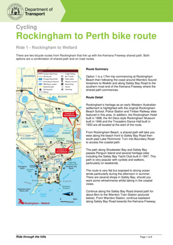
CyclingRockingham to Perth bike routeRide 1 - Rockingham to WellardThere are two bicycle routes from Rockingham that link up with the Kwinana Freeway shared path. Bothoptions are a combination of shared path and on-road routes.Route SummaryOption 1 is a 17km trip commencing at RockinghamBeach then following the coast around Warnbro Soundforeshore to Waikiki and along Safety Bay Road to thesouthern most end of the Kwinana Freeway where theshared path commences.Route DetailRockingham’s heritage as an early Western Australiansettlement is highlighted with the original RockinghamBeach School, Police Station and Timber Railway sitesfeatured in this area. In addition, the Rockingham Hotelbuilt in 1898, the Art Deco style Rockingham Museumbuilt in 1946 and the Trocadero Dance Hall built in1933 are all located at the start of the route.From Rockingham Beach, a shared path will take youwest along the beach front to Safety Bay Road thensouth past Lake Richmond. Turn into Boundary Roadto access the coastal path.The path along Shoalwater Bay and Safety Baypasses Penguin Island and several heritage sitesincluding the Safety Bay Yacht Club built in 1947. Thispath is very popular with cyclists and walkers,particularly on weekends.The route is very flat but exposed to strong oceanwinds particularly during the afternoon in summer.There are several shops in Safety Bay, should youwant some refreshments whilst taking in the coastalviews.Continue along the Safety Bay Road shared path forabout 6km to the Warnbro Train Station (picturedbelow). From Warnbro Station, continue eastwardalong Safety Bay Road towards the Kwinana Freeway.Ride through the hillsPage 1 of 8
Between Warnbro Station on the east side of Ennis Ave, and the Freeway shared path you will ride past LakeWalyungup on the south side of Safety Bay Road. This wetland area provides an important habitat forwaterfowl, migratory wading and other birds as well as the rare Black Gloved Wallaby.The on road route along Safety Bay Road has sealed shoulders (bike lanes) but it should be noted that theroad also carries a large volume of freight traffic and may be less appealing to inexperienced cyclists. Extracare should be taken where the route intersects busy roads, particularly at roundabouts.The Kwinana Freeway shared path commences on the western side of the Kwinana Freeway. The pathconnects with the Rockingham – Kwinana route at Mortimer Rd in Wellard, about 9kms north of the start ofthe path at Safety Bay Road. (Option 2 on the following page).Experienced and energetic cyclists might consider riding the 38km Rockingham round trip by using the pathsection to connect the two Rockingham options.Route Features Rockingham BeachLake RichmondPoint PeronWarnbro Sound & Penguin IslandLake WalyungupWarnbro Train StationRockingham to Perth bike routePage 2 of 8
Ride 2 - Rockingham to KwinanaRoute SummaryOption 2 is a 14km trip from Rockingham Beach, alongRockingham Beach Road to Kwinana Beach. Theroute then continues east through East Rockinghamand Kwinana and connects with the Kwinana Freewayshared path at Mortimer Road in Wellard.Route DetailThe route commences at Churchill Park with itsdistinctive peppermint trees planted in the 1920’s.The 4km bike route along Rockingham Beach Roadfollows the coast where you can take advantage of anyof the several picnic areas and enjoy the views acrossCockburn Sound. As well as playgrounds, picnicfacilities and public toilets, there are also a number ofcafes along this route section.From Kwinana Beach at the northern end ofRockingham Road, follow the PBN route signs east(paying particular care when crossing Patterson Road).About 2.5kms from Kwinana Beach, you will come toMandurah Road where you can deviate south to theEast Rockingham Heritage Precinct to visit more earlysettlement sites such as the East RockinghamCemetery established in 1842.If you choose to take this deviation, a little further southaround Chesterfield and Day Roads, you should beable to identify Chesterfield House built in 1855,Woodbine (Bell Cottage) ruin built in 1868, andEllendale (Day Cottage) which for a short time in the1880’s operated as the Rockingham Inn. MandurahRoad does not have bicycle lanes or sealed shouldersbut traffic is not usually heavy and there are goodsightlines along the road. If you take this deviation, youmight consider making the return 5km trip toRockingham west along Dixon Road.Continuing along the main route option from theMandurah to Wellard Road intersection, it isapproximately 7km to the Freeway shared path. Alongthe way, you can deviate north at Gilmore Ave toaccess the Kwinana Town Centre, about 1km from thebicycle route.Route Features Rockingham to Perth bike routeRockingham and Kwinana BeachesChurchill Park and surrounding heritage sitesEast Rockingham heritage sitesAccess to Kwinana Town CentrePage 3 of 8
Ride 3 - Kwinana to WattleupRoute SummaryThis section of the route is about 8km in length and willtake you from the Kwinana area, north toward Perth onthe Freeway shared path. The path has underpassesat, and access to, all major roads including Thomas,Anketell and Rowley Roads.Route DetailThomas Road provides access to the Kwinana TrainStation as well as the suburbs of Orelia and Medina.Immediately north of Thomas Road, the route takesyou past The Spectacles in Beeliar Regional Park - a3.7 square kilometre wetland.To explore this remarkable wetland by the walk andcycle trails, take the Anketell Road exit from the sharedpath and cycle about 50 metres west to SpectaclesDrive then about 1.5kms south. Bird hides providelocations to observe some of the 100 different birdspecies inhabiting the wetlands.Anketell Road also provides a connection with a LocalBicycle Route (LBR) SW34, an on road bike routeproviding an alternate route north to South Lake.Route Features Rockingham to Perth bike routeThe Spectacles : Beeliar Regional ParkKwinana Railway StationLocal Bicycle Route SW34Page 4 of 8
Ride 4 - Wattleup to SuccessRoute SummaryThe section of route between Rowley Road andBeeliar Drive is about 6 km in length and is entirely onshared path.Route DetailRowley Road is a designated Perth Bicycle NetworkLocal Bicycle Route (SW18) and provides access toHenderson, approximately 6km to the west, andArmadale, approximately 18km to the east. About2.5km to the north is the Russell Road intersection.Russell Road is also a designated Local Bicycle Route(SW17) and provides access to Thomsons LakeNature Reserve and Henderson Industrial area on thecoast.Thomsons Lake contains about 150ha of semipermanent wetland surrounded by woodland providinga habitat for local and migratory birds and nativeanimals including grey kangaroos, brush wallabies,brush-tailed possums and short-nosed bandicoots.There are several paths providing convenient links intonew urban areas adjacent to the route. Shops to thewest on Beeliar Drive at Gateways Shopping Centreprovide an opportunity for refreshments. There is abike shop and bicycle parking at the Centre.Route Features Rockingham to Perth bike routeThomsons Lake Nature ReserveLocal Bicycle Route SW17Local Bicycle Route SW18Page 5 of 8
Ride 5 - Success to MurdochRoute SummaryThe section of route between Beeliar Drive and SouthStreet is about 7km in length and provides access toBerrigan Drive, Farrington Road and South Street.Route DetailImmediately north of Beeliar Drive, there is aconnection from the shared path into the CockburnCentral Train Station (pictured below). The Station hashigh quality bicycle parking rails and lockers that youmay consider using if you take the train.Further north at the intersection of Roe Highway andKwinana Freeway, with its distinctive urban art, thereare several path links into the Bibra Lake suburbanarea.From here is a short ride to Bibra Lake, a very popularpicnic destination named after Benedict von Bibra.There is a 7km cycle path around the lake that ispopular for bird watching, offering a wide variety ofhabitats. Long-necked Tortoises are often seen in thisarea.The South Street exit provides access via shared pathsto Murdoch Train Station, Murdoch University andMurdoch Hospital. If you live in the area and commuteto Perth or other locations on the suburban rail network,you might consider making use of the high qualitybicycle parking facilities at Murdoch Station. A shortride to the station is an invigorating way to start yourday.Route Features Rockingham to Perth bike routeCockburn Central Train StationBibra Lake “Walliabup”Murdoch Train Station,Murdoch UniversityMurdoch HospitalPage 6 of 8
Ride 6 - Murdoch to Canning BridgeRoute SummaryThe section of route between South Street andCanning Bridge is about 6 km in length andprovides access to the Cities of Melville, Canningand South Perth, as well as the Bull Creek andCanning Bridge Train Stations.Route DetailBull Creek Train Station is located at the KwinanaFreeway – Leach Highway intersection. It has goodbicycle parking facilities for those who mightconsider cycling from surrounding areas to the trainstation.It is an easy 2km ride from South Street to LeachHighway. Between Leach Highway and MountHenry Bridge, there is a short on road section ofroute along Selway Road, a quiet suburban street,and a crossing over Cranford Avenue. Aftercrossing Cranford Avenue you will connect with theshared path for a short section before comingacross a fantastic panoramic view of the city skylineand Kings Park, across the Swan and CanningRivers.From the southern end of Mt Henry Bridge you canride on paths on either the west or east sides of theCanning River. The western route will take you viaDeep Water Point Reserve to Canning Bridge. Thisis a popular location for water skiing and other riverbased activities and can get very busy onweekends. There is a café overlooking the Riverand change rooms with showers and toilets.The eastern route will take you through revegetatedbushland to Canning Bridge. Along this section,there are two overpasses across the Freewayproviding access to Manning and to CurtinUniversity, approximately 3km to the east.Route Features Rockingham to Perth bike routeBull Creek Train StationCanning RiverDeep Water Point ReservePage 7 of 8
Ride 7 - Canning Bridge to Narrows BridgeRoute SummaryThe final 6km section of the Southern Suburbs route willtake you from Canning Bridge along the edge of theSwan River to the Narrows Bridge. This section of pathprovides unrestricted access from the southern suburbsto central Perth and is very popular with commuter andrecreational cyclists as well as pedestrians and joggers.Route DetailCanning Bridge Train Station is located in the centre ofthe Freeway and accessible from shared path links onthe south and north sides of Canning Bridge.About 2km north of Canning Bridge is Como Beach andJetty. The Jetty was built in 1907. In the 1920’s, thearea was promoted as a recreation area for residentsand visitors and is still a popular recreation area forresidents and a pleasant rest area for cyclists.South Perth was one of the earliest developed areasfollowing settlement of the Swan River Colony. On theother side of the Freeway is the Preston Street Precinct,a compact mixed-use area with shops, cafés,restaurants, a tavern and the classically beautiful artdeco Cygnet Cinema. Closer to the Narrows Bridgealong Labouchere Road is Perth Zoo that wasestablished in 1898 but more recently committed toconservation of native and exotic species to ensure thesurvival of species in the wild.Close to the Narrows Bridge is the Old Mill, a stonestructure with simple clear lines. It a picturesque earlycolonial building that has been restored and is open tothe public.From the Narrows Bridge, it is just a short ride acrossthe Narrows Bridge to Perth City and other bike routesextending into northern, western and eastern urbanareas.Route Features Rockingham to Perth bike routeCanning Bridge Train StationSwan RiverComo Foreshore ReservePreston Street & Cygnet TheatrePage 8 of 8
The path connects with the Rockingham – Kwinana route at Mortimer Rd in Wellard, about 9kms north of the start of the path at Safety Bay Road. (Option 2 on the following page). Experienced and energetic cyclists might consider riding the 38km Rockingham round trip by using the pat