Transcription
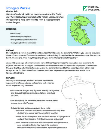
Pangea PuzzleGrades 4-8Use fossil and rock evidence to reconstruct how the Earthmay have looked approximately 290 million years ago whenthe continents were connected to form a supercontinentcalled Pangea.MATERIALS World map Landmass puzzle pieces Pangea Map Symbols handout Analyzing Evidence worksheetENGAGEShow students a current map of the world and ask them to name the continents. What do you observe about theshape of the continents? Some of the continents look as if they fit together like the pieces of a puzzle. Discuss howSouth America and Africa may fit together. Do you think other continents fit together?About 100 years ago, a German scientist named Alfred Wegener made the observation that continents fittogether. This led him to suggest a new idea that the continents were once part of a single piece of land calledPangea. It split apart millions of years ago and the continents moved to their present position. Others hadrecognized the fit of Africa and South America, but it was Wegener who gathered other scientific datato support his theory.EXPLOREWorking in small groups, students will piece together thesupercontinent Pangea based on fossil and rock evidencefound on present day continents. Introduce the Pangea Map Symbols. Identify the symbolsand discuss that these animals and plants once livedon Earth. Give each group the landmass pieces and have studentsarrange them into Pangea. If students need assistance, provide these hints:º Observe continent shapes on the world map to help themdecide if any appear as if they might fit together.º Look for all of the pieces with the fossil remains of Cynognathusand put them together first (South America and Africa).º Put all of the landmasses with Glossopteris and Lystrosaurusnear each other. Notice how two of the continents(Africa and Antarctica) have the end regions of Lystrosaurus.
EXPLAIN How did continent shape help in deciding where to place the continents?Which two continents have the most obvious fit of the coastlines? How did the fossil and rock evidence help in deciding where to place the landmasses? Which fossil occurs on most of the landmasses?What does that suggest when these particular continents broke up? Locate Florida. To which continent was it once attached?EXTEND and EVALUATE Have each group explain their Pangea arrangement.If students don’t get the “correct” answer, have them explain their thought process and how they usedthe evidence to arrive at their conclusion.Students should understand that using the shape of the continents to fit them back together is using onetype of evidence. Using the presence of the same type and age fossils is another. The presence of the samerock types is another form of evidence. Ask students if they can think of other types of evidence to searchfor that might be useful in solving their puzzle. Have students use Wegner’s Evidence for Continental Drift to write a paragraph to explain whattheir map shows about the Earth 290 million years ago. Explain how the fossil evidence helpedto piece the landmasses together.There is much information missing from the picture. For example, ancient shorelines were not thesame as they are today due to changes in sea level and the tectonic process (continents colliding andpulling apart, causing rocks to be added or torn off). Scientists still debate the fine details ofpaleogeographic (ancient geography) reconstruction. It is more important to have students grasp theconcept of how scientists look for clues, or evidence, and put the pieces together to solve a problem. Complete the Analyzing Evidence worksheet.
WEGNER’S EVIDENCE FOR CONTINENTAL DRIFTEvidence from fossilized organisms and mountain chains can be used to reconstruct the positions of today’scontinents and landmasses to form the supercontinent Pangea.Glossopteris ferns had very heavy seeds that could not move by wind or drift on oceancurrents. Fossils have been found on all the southern continents – Australia, Antarctica,India, South Africa and South America.The Mesosaurus was a reptile that lived in fresh or brackish water and had limbs forswimming but was not a strong swimmer. It would not likely have had the capability toswim across such a large body of water as the Atlantic Ocean.Cynognathus was a mammal-like reptile that lived on land during the Early Triassic.It was as large as a modern wolf. Its fossils are found only in South Africa and SouthAmerica. As a land-dominant species, it would not have been capable of migratingacross the Atlantic.Lystrosaurus was another mammal-like reptile that lived on land. It survived thePermian Period and was dominant during the early Triassic. Its anatomy suggests thatthese animals were probably very poor swimmers.By about 300 million years ago, a unique community of plants had evolved known asthe European flora. Fossils of these plants are found in Europe and other areas.Scientists study rocks from mountain chains, and the fossils found in them, to understand continental drift. The mountainous terrains of separate continents match up.
BACKGROUND INFORMATIONAlfred Wegner was a German geophysicist who formulated the first complete statement of the continentaldrift hypothesis. Although he was not the first to suggest that continents have moved about the Earth, hispresentation of carefully compiled evidence inspired decades of scientific debate. Wegener’s evidence, alongwith evidence provided by post World War II technology, eventually led to universal acceptance of the theoryof continental drift.Alfred Wegener collected diverse pieces of evidence to support his theory, including geological “fit” and fossilevidence. Geological “fit” evidence is the matching of large-scale geological features on different continents.The coastlines of South America and West Africa seem to match up. Scientists have found that rocks on the eastcoast of South America are the same as rocks found on the west coast of Africa. These rocks are different fromrocks found in other places on Earth, suggesting that the continents were once connected.Plant and animal fossils also reveal evidence. There are various examples of fossils found on separate continentsand in no other regions. This indicates that these continents were once joined together because the extensiveoceans between these land masses act as a barrier for fossil transfer. Examples include: Mesosaurus,Cynognathus, Lystrosaurus and Glossopteris.How did the continents move apart? The Earth’s outermost layer (crust) is not one solid piece. It is broken intosections, like a cracked egg shell. The sections are called tectonic plates and continents are part of these largeplates. The tectonic plates are floating on top of the molten rock and moving around the planet. When thecontinents and plates move it is called continental drift. Some plates move into each other, while others moveaway from each other. The movement of the plates is responsible to the formation of ocean basins, mountainranges, volcanoes and earthquakes.Over the past 100 years, scientists have continued to find evidence supporting the idea that the Earth was onceone supercontinent called Pangea. Pangea formed before the early Permian Period began 290 million years agoand broke apart approximately 220-225 million years ago.On Pangea, Florida was once connected to the land mass that was to become Africa. When Pangaea brokeapart, Florida remained attached to North America and drifted to its present position. Florida did not emerge aspermanent dry land until approximately 30 million years ago. Before that time, the continental shelf underneathpresent day Florida was still submerged under an ancient ocean.Florida appeared when ocean water levels lowered (as water became locked in the ice as the Earth cooled)and sediment continued to build, raising the land surface. The sediment was primarily from two sources1) the accumulation of marine fossils and 2) erosion washed down from the Appalachian Mountains.Over time, the lowering sea level and rising surface formed what is now Florida.
GRADE 4 STANDARDSSC.4.N.1.1 Raise questions about the natural world, use appropriate reference materials that supportunderstanding to obtain information (identifying the source), conduct both individual and teaminvestigations through free exploration and systematic investigations, and generate appropriateexplanations based on those explorations.SC.4.N.1.2 Compare the observations made by different groups using multiple tools and seekreasons to explain the differences across groups.SC.4.N.1.3 Explain that science does not always follow a rigidly defined method (“the scientificmethod”) but that science does involve the use of observations and empirical evidence.SC.4.N.1.4 Attempt reasonable answers to scientific questions and cite evidence in support.SC.4.N.1.5 Compare the methods and results of investigations done by other classmates.SC.4.N.1.7 Recognize and explain that scientists base their explanations on evidence.
Analyzing Evidence: Pangea and Continental DriftEvidence or not? Read the statement in each box and check whether the statementis evidence or not in the left columns, and whether it supports the movement of thecontinents in the right column.Is itevidence?YESSTATEMENTSNODoes it supportthe idea thatcontinentsmoved?YESNO1858: Geologist Eduard Seuss points out that fossils of the Glossopteris plantare found in southern Africa, South America, Australia, Antarctica, and India.Wegener examines the location of tiny rocks and the direction of groovesformed by large glaciers scraping across southern areas of Africa, SouthAmerica, Australia, Antarctica, and India. He concludes that if all theseplaces were fitted together, they would form a continuous ice sheet expandingoutward in all directions.Frankfurt News, January 6, 1912: Announcement that German scientist AlfredWegener will speak at the Geological Association meeting.Popular Geology magazine, March 12, 1912: “Continents are so large they mustalways have been where they are.”Wegener observes that a South American mountain range in Argentina linesup with an ancient African mountain range in South Africa when the twocontinents are placed together. He writes: “It is just as if we were to refit thetorn pieces of a newspaper by matching their edges and then check whetherthe lines of print ran smoothly across. If they do, there is nothing left but toconclude that the pieces were in fact joined in this way.”1927: Geologist Alexander du Toit observes rock layers on the western coastof Africa in the following sequence: basalt rock, shale containing fossilreptiles, coal layers containing Glossopteris fossils, rocks containing Mesosaurusfossils, and shale. He discovers an almost identical sequence of rock layers onthe eastern coast of South America.1944: Geologist Baily Willis calls Wegener’s theory a fairy tale. He argues thatthe theory should be ignored.1965: Geologist Edward Bullard uses computers to match coasts of SouthAmerica and Africa. They match extremely well at an ocean depth of 1,000meters (3,280 ft).1980s: Satellites and lasers are used to measure the movement of continents.They continue to move at an average of about 2 cm (0.8 in) per year.Fossils of Megascolecina earthworms are found in South America, Africa, India,and Australia, as well as the islands of Madagascar and New Guinea.Modified from U.S. Geological Survey, 2008, This Dynamic Planet; A Teaching Companion Wegener’s Puzzling Continental Drift Evidence
GreenlandIndiaThe European FloraCynognathus reptileLystrosaurus reptileGlossopteris plantMesosaurus reptileModified from the U.S. Department of the Interior and the U.S. Geological SurveyAlpine Mountains
GreenlandIndiaFossil Evidence KeyThe European FloraCynognathus reptileLystrosaurus reptileGlossopteris plantMesosaurus reptileAlpine MountainsModified from the U.S. Department of the Interiorand the U.S. Geological Survey
Landmass puzzle pieces Pangea Map Symbols handout Analyzing Evidence worksheet . By about 300 million years ago, a unique community of plants had evolved known as . Wegener examines the location of tiny rocks and the direction of grooves formed by large gla