Transcription
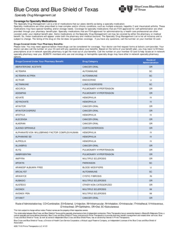
Tennessee Blue Book: Student EditionA History of TennesseeChapter 1: The Land and Native PeopleTennessee has a great variety of rivers, landforms, climate regions, and plant andanimal species. Numerous groups of people have settled in Tennessee beginningwith Native Americans about 12,000 years ago. The lasting impact of NativeAmericans can be seen in the number of places with Native American names. Infact, the name “Tennessee” comes from the Native American word “Tanasi.” Settlerscame to Tennessee to take advantage of its abundant natural resources, so it seemsfitting to begin by describing the land of Tennessee.Tennessee divides naturally into three “grand divisions:” East Tennessee, MiddleTennessee, and West Tennessee. East Tennessee is an upland, often mountainousEastern Highland RimWestern ValleyMississippiRiverValleyWesUplat Tennnds astal Plain02550Scale75100 MilesInner BasinSequatchie ValleyPhysiographic Map of Tennesseeregion. Middle Tennessee has foothills surrounding a lowland area known as a basin.The land of West Tennessee is part of the Gulf Coastal Plain. Travelers coming tothe state from the east first encounter the towering Unaka and Smoky Mountains,followed by the Great Valley of East Tennessee. Moving across the Valley floor, theynext face the Cumberland Plateau, which historically attracted little settlementand presented a barrier to westward migration. West of the Plateau, the terraindescends into the Central Basin of Middle Tennessee—a rolling, fertile countrysidethat drew hunters and settlers alike. The Central Basin is surrounded on all sidesby the Highland Rim—the western ridge of which drops into the Tennessee RiverValley. Across the river in West Tennessee begin the low hills and alluvial plain. Analluvial plain is formed from deposits of gravel, clay, and sand carried by a river.These geographical “grand divisions” correspond to the distinctive political andeconomic cultures of the state’s three regions.Tennessee possesses a climate favorable for people and agriculture, with abundantrainfall and mild temperatures which create a long growing season for plants. The
Tennessee Blue Book: Student Edition Chapter 1: The Land and Native Peoplearea is generally free from the long droughts and freezes found in some regions ofthe United States. The three major rivers that flow around and across Tennessee—theCross section map of Tennessee from the Unaka Mountains to the Mississippi RiverMississippi, Tennessee, and Cumberland Rivers—have created watersheds that covermost of the state. A watershed is an area of land drained by a particular river orstream. The Tennessee River forms near Knoxville and flows in a southwesterlydirection into Alabama, then loops back north to the Kentucky border. TheCumberland River drains northern Middle Tennessee, and West Tennessee is covered by a network of slow-moving streams, swamps, and lakes that flow directlyinto the Mississippi River. These rivers and the smaller streams that feed into themEarly map showing the Mississippi, Tennessee, and Cumberland River systems2
Chapter 1: The Land and Native People Tennessee Blue Book: Student Edition3The Land and Native Peoplehave played a significant role from the earliest times by providing fish and shellfish,by serving as major transportation routes, and by creating the areas of fertile soilsthat attracted farmers.Fossils found in rocks across Tennessee show that the state was covered by warm,shallow seas in the distant past. Coal-bearing layers of rock are found throughoutthe Cumberland Plateau. Plant and dinosaur fossils are found in the sandstones ofWest Tennessee. Mammoths, mastodons,and giant sloths were driven south by theadvancing glaciers of the Ice Age. Theirremains can be found in West and MiddleTennessee.The story of man in Tennessee beginswith the last retreat of the Ice Age glaciers, when a colder climate and forestsof spruce and fir covered the region. LateIce Age hunters probably followed animalherds into this area about 12,000–15,000years ago. These nomadic Paleo-Indianscamped in caves and rock shelters andleft behind their distinctive arrowheadsEarly man hunted mastodon that roamed during the last Ice Age.and spear points. They may have used The Mastodon Hunt. Painting by Carlyle Urello, courtesy of thesuch Paleolithic or Stone Age tools to Tennessee State Museum.hunt the mastodon and caribou that livedin eastern Tennessee. About 12,000 years ago, the region’s climate began to warm,and the vegetation changed from being mostly conifers to our modern deciduousforest. Large numbers of deer and elk were attracted to the abundant supply ofmast, or food produced by oak, hickory, chestnut, and beech trees. Warmer climate,the extinction of the large Ice Age mammals, and the spread of deciduous forestsworked together to transform Native American society.During what is known as the Archaic period, descendants of the Paleo-Indiansbegan to settle on river terraces. River terraces are areas of flat land raised abovethe valley floor. Archaic people gathered wild plant food and shellfish in additionto hunting game. Sometime between 3000and 900 BC, natives took the crucial stepof growing edible plants such as squashand gourds—the beginning of agriculture.Growing crops provided Archaic peoplewith a dependable food supply and freedthem from seasonal shortages of wild plantfoods and game. With a more secure foodsupply, populations grew rapidly and scattered groups combined to form larger Woodland Indians first developed farming in Tennessee.Woodland Indians farming in Tennessee. Painting by Carlylevillages.The next major stage of Tennessee pre- Urello, courtesy of the Tennessee State Museum.history lasted almost 2,000 years and is
Tennessee Blue Book: Student Edition Chapter 1: The Land and Native Peopleknown as the Woodland period. During this era, Native people began to makecontainers and other objects out of clay. This craft is known as pottery. They alsobegan to live in settled farming communities and to construct burial mounds.Wealth increased and Native society began to stratify, or divide, into different socialclasses. Native Americans in Tennessee made the transition from societies of hunters and gatherers to well-organized tribal, agricultural societies living in large,permanent towns.The peak of prehistoric cultural development in Tennessee occurred during theMississippian period (900–1600 AD). Population grew after the introduction ofnew varieties of corn and beans. As chieftains became more powerful, territorialwarfare increased and ceremonial temples and public structures were built. Thecomplexity of Mississippian society is seen in the elaborate pottery styles and personal items, such as combs, pipes, and jewelry, it produced.Stone pipe from Roane County (left) and engraved shell gorget (right), both from the Mississippian period. Images courtesy of theTennessee State Museum.People who do not have their own written language are often forgotten or knownmostly from the documents written by their conquerors. This is what happenedto the native inhabitants of Tennessee. Most of what is known about their culturecomes from the writings of European Americans who often viewed Native Americanculture as inferior to their own culture. Disease, warfare, and the European fur tradehad transformed Native American society long before white settlement reached theTennessee country.The Cherokee were not the first inhabitants of East Tennessee. Archeologicalevidence shows that East Tennessee had densely populated native communitiesprior to European contact. Native Americans in Tennessee began to grow maize,or corn, around 800–1000 AD. This development allowed towns and villages togrow rapidly. During the Mississippian period, organized chiefdoms developed inpopulation centers such as Pinson Mounds in the west, Mound Bottom in MiddleTennessee, and Toqua and Citico in East Tennessee. In 1540–1542, HernandoDeSoto led a group of 600 conquistadors, or Spanish soldiers, through the mountains into East Tennessee where he encountered the remnants of this civilization.4
Chapter 1: The Land and Native People Tennessee Blue Book: Student Edition5The Land and Native PeopleSpanish entradas, or exploratory expeditions, led by DeSoto, Tristan de Luna, andJuan Pardo, came through the region between 1540 and 1567.When the English and French began to explore the region 150 years later,the densely populated valleys and towns that DeSoto had found were gone ordeserted. Historians are not certain what happened to these early inhabitants. Themost likely explanation is that the Native Americans were wiped out by diseasessuch as smallpox and measlescarried by the Spanish. BecauseNative Americans had never beenexposed to European diseases,they had no natural resistance,or immunity, to the diseases. Theintroduction of European diseasesto North and South America wasone aspect of the ColumbianExchange. The C olumbianExchange refers to the exchangesof plants, animals, diseases, andtechnology between the OldSaul’s Mound, which stands at seventy-two feet, at Pinson Mounds StateWorld (Europe, Africa, and Asia)Archaeological Park.and the New World (North andSouth America) following Columbus’s voyage in 1492.Some of the indigenous or native peoples, such as the Yuchi, remained, but theywere driven out in the early eighteenth century by the Cherokee, who apparentlymigrated into the region after it was emptied by disease. There is evidence of alarge-scale massacre at the Yuchi town of Chestowee in 1714. Cherokee hostilityprobably caused the Yuchi to abandon eastern Tennessee and settle further southin Georgia. The Yuchi people were one of the early tribes of eastern Tennessee.“Tanasi,” which gave its name to the state, may have originally been a Yuchi word,as was “Hogohegee,” the name given to the Tennessee River on many eighteenthcentury maps.The arrival of French explorers and Virginian traders in the mid-1600s markedthe beginning of the end of Tennessee’s native culture. For the next hundred years,the trade in deer and beaver pelts was the main connection between EuropeanAmericans and Native Americans. From the western reaches of Virginia and theCarolinas into what would be known as Tennessee, the Cherokee ruled, havingearlier driven the Creek, Yuchi, and Shawnee from the region. They were the lastnative group to actually live in part of Tennessee. The colonial fur trade wouldchange the Cherokee way of life forever. The system made the Cherokee dependenton European trade goods and led to the overhunting of game. At the same time,trade greatly increased intertribal warfare. It also drew the Cherokee into Europeanwars, such as the French and Indian War at the end of the eighteenth century. Soon,Europeans would come seeking land, not deerskins, from the Native Americans.
Tennessee Blue Book: Student Edition Chapter 2: Struggle for the FrontierChapter 2: Struggle for the FrontierTerms & Definitions Cede—to give up Flotilla—fleet of ships Gap—a low area betweenmountains Land speculators—businessmen who obtainedcheap land from the NativeAmericans hoping to resellit at a profit to incomingsettlers Land survey—a land surveylocates, describes, and mapsthe boundaries of a pieceof land Longhunters—men whocrossed the AppalachianMountains to hunt deer andother game for six or moremonths each year Military alliance—anagreement between twogroups to assist each otherin war Militia—groups of ordinarycitizens who fight in times ofemergency Pack train—lines of horsesor mules that carried goodson their backs across themountains Petition—a formal writtenrequest to a person or groupsuch as a government Stations—log homessurrounded by walls andused as forts during attacksNew tribes moved into the Tennessee region afterDeSoto’s visit. The Cherokee built their towns and villages along the Hiwassee and Little Tennessee Rivers.The Chickasaw Nation controlled the territory west ofthe Tennessee River. The Shawnee, a large Ohio Valleytribe, moved south into the Cumberland River area butwere driven out by Chickasaw and Cherokee attacks.After 1715, Middle Tennessee had no Indian towns,although several tribes used it as a common huntingground.Tennessee in 1796; note the separation of East and Middle Tennessee by Indianterritory.In 1673, both British and French explorers claimedthe region. James Needham and Gabriel Arthur, Britishtraders from Charles Town (later Charleston), SouthCarolina, crossed the Appalachians to establish tradewith the Cherokee. Father Jacques Marquette and furtrader Louis Joliet came down the Mississippi River andclaimed its entire valley for the King of France. Britainand France later built forts and trading posts in theregion to reinforce their competing claims.The early fur traders lived among the Indians andemployed Indian hunters to supply them with beaverskins and deer pelts, or skins. The furs were thenshipped downriver to New Orleans or carried on packtrains to Charles Town. Pack trains were lines of horsesor mules that carried goods on their backs across themountains. South Carolina merchants dominated theearly Tennessee fur trade. In 1748, they exported morethan 160,000 skins worth 250,000. In return for furs,Indians received cloth, iron goods, and guns. The furtrade was profitable for the traders, but it wiped out6
Chapter 2: Struggle for the Frontier Tennessee Blue Book: Student EditionCumberland Gap, the early passage to Kentucky and Middle Tennessee7Struggle for the Frontiermuch of Tennessee’s native animal life. As the British and French competed forcontrol of the valuable fur trade, they negotiated trade agreements and militaryalliances with Indian tribes. A military alliance is an agreementbetween two groups to assist eachother in war.The competition between Franceand Britain for control of NorthAmerica led to the start of theFrench and Indian War in 1754.Both the British and the Frenchneeded the help of their NativeAmerican allies in fighting the war.English soldiers built Fort Loudounnear present-day Vonore in an effortto keep the Cherokee loyal.However, the plan did not work.Cherokee warriors laid siege or surrounded the fort and starved out thesoldiers inside. After surrenderingthe fort, the retreating soldiers wereattacked by the Cherokee, and manysoldiers were killed. The Britisheventually won the war despite theirloss at Fort Loudoun. As a result,France ceded, or gave up, all itsclaims to land east of the MississippiFort Loudoun on the Tennessee RiverRiver in 1763. Tired after years offighting, the British hoped to avoidfurther conflict with Native Americans by prohibiting settlements beyond theAppalachian Mountains in the Proclamation of 1763. Although still powerful, theCherokee had lost some of their independence by forming military alliances andtrade because their landswere directly in the path ofmigration across themountains.As early as 1750, colonialexplorers began to crossthe mountains and exploreCherokee lands. Whileworking for the Loyal LandCompany of Virginia, Dr.Thomas Walker discovered the Cumberland Gap.A gap is a low area between
Tennessee Blue Book: Student Edition Chapter 2: Struggle for the Frontiermountains. The Cumberland Gap was used by Native Americans and later by colonial settlers to reach Tennessee and Kentucky. Throughout the 1750s and 1760s,longhunters crossed the mountains into Cherokee territory. Longhunters earnedtheir name by hunting for six to seven months before returning home. The longhunters shared their knowledge of the lands westof the Appalachian Mountains which encouragedsettlers like William Bean to ignore theProclamation of 1763 and move west into the valleys of East Tennessee.By the early 1770s, four different communities had been established in northeasternTennessee—on the Watauga River, the NorthHolston, the Nolichucky, and in Carter’s Valley.The settlers claimed that they were living onland that was part of Virginia, but a land survey showed that claim to be false. A land surveylocates, describes, and maps the boundaries of apiece of land. Because the Proclamation of 1763prohibited buying land from the Cherokee, thesettlers negotiated leases for their farms instead.Since Watauga and the other settlements wereoutside the boundaries of the colonies, coloniallaw did not apply. As a result, the independentminded settlers created their own governmentA page from the Watauga Purchase, the firstin a document called the Watauga Compact intransfer of land in Tennessee from natives tosettlers such as William Bean1772.In addition to settlers, land speculators fromVirginia and North Carolina also raced to acquire western lands. Land speculatorswere businessmen who obtained cheap land from the Native Americans, hoping toresell it at a profit to incoming settlers. In March of1775, Richard Henderson of North Carolina negotiated a private treaty with the Cherokee for thepurchase of twenty million acres of land that includedmost of Kentucky and Middle Tennessee. In return,the Cherokee received six wagon loads of goods worthabout 10,000 English pounds. The deal was known asthe Transylvania Purchase. Henderson hired DanielBoone to cut a trail through the Cumberland Gap thatbecame known as the Wilderness Road. A few dayslater, the settlers asked the Cherokee to turn their leaseinto a purchase. Cherokee leaders such as LittleCarpenter agreed, and the deal became known as theWatauga Purchase. Other Cherokee leaders wereopposed to any plan to sell their ancestral lands.Daniel BooneDragging Canoe warned the settlers that they were8
Chapter 2: Struggle for the Frontier Tennessee Blue Book: Student Edition9Struggle for the Frontierpurchasing a “dark and bloody ground.” He retreated south to establish the warlikeChickamauga tribe, which attacked Tennessee settlements for the next twenty years.The Wataugans’ willingness to ignore theProclamation of 1763 and purchase land from theCherokee demonstrated their contempt for thestrict rules of the British government. Despite theirisolation, the Wataugans were aware of the increasing anger towards the British governmentdemonstrated in events such as the Boston Massacreand the Boston Tea Party. However, the Wataugans’most important problem was continued hostilityfrom the Cherokee. The Cherokee, angry about losing more and more land to the settlers, alliedthemselves with the British in the RevolutionaryWar. Concerned about the safety of the settlements,the Wataugans asked North Carolina for help in adocument known as the Watauga Petition. A petition is a formal written request to a person orgroup, such as a government. North Carolinaagreed to help, and the settlements became a partof the state known as the Washington District.Great Cherokee leaders such as OconostotaIn July 1776, the Cherokee launched well- and Attakullakulla signed the WataugaPurchase.planned attacks on the East Tennessee settlements.The Wataugans, led by their popular leader JohnSevier, stopped the Cherokee and swiftly counterattacked. The settlers were helpedby Cherokee leaders who wanted toavoid war, such as Beloved WomanNancy Ward. Militia from NorthCarolina and Virginia assisted theWataugans as well. Militia are groups ofordinary citizens who fight in times ofemergency. The Wataugans invadedCherokeeterritoryand burnedseveraltowns. Thisseries ofMero (outlined in red) and Washington (outlined in gold)districts of early Tennesseebattles isknown asthe Cherokee War. The alliance with Britain was a mistake for the Cherokee. The alliance gave the Americansan excuse to reduce the tribe’s military power and takemore land after the war. Following the Cherokee War,the Wataugans focused on matters at home until theJohn Sevier
Tennessee Blue Book: Student Edition Chapter 2: Struggle for the Frontierfall of 1780. Responding to a threat made by British Major Patrick Ferguson, JohnSevier and Isaac Shelby led a group of militiamen over the mountains to fight Fergusonand his Tory, or Loyalist, troops at the Battleof Kings Mountain on October 7, 1780. TheOvermountain Men were joined by militiafrom Virginia and North Carolina. ThePatriot force defeated Ferguson’s troops andset in motion the chain of events that endedone year later with Cornwallis’s surrender atYorktown.The Revolution gave settlers an openingto push the frontier westward to theCumberland River. Longhunters such asJames Robertson, Kasper Mansker, andThomas Sharpe Spencer had hunted andtrapped through Middle Tennessee andspoke of its richness to their neighbors athome. Following the Transylvania Purchase,Henderson hired Robertson to plan a settle- Letter from Isaac Shelby to John Sevier about Kingsment along the Cumberland River. In the Mountainwinter and spring of 1779, 300 pioneersmade the difficult trek to French Lick, the future site of Nashville. French Lick wasthe location of a natural salt lick along the Cumberland River that had been thelocation of a French trading post. Most of the men came overland under Robertson’sFront cover and page from a journal kept by John Donelson on his voyage to French Lick, the future site of Nashville10
Chapter 2: Struggle for the Frontier Tennessee Blue Book: Student EditionBluff Station in Nashville, later known as Fort Nashborough11Struggle for the Frontierleadership, while John Donelson led a flotilla, or fleet of ships, carrying women,children, and enslaved people on a hazardous voyage down the Tennessee Riverand up the Cumberland River. The travelers endured freezing temperatures andattacks from the Chickamauga before reaching their destination. Because theCumberland Settlement was outside the boundaries of the colonies, the settlersformed their own government in a document known as the Cumberland Compact.This first band of settlers established anumber of fortified stations and spreadacross the Central Basin in search ofgood farmland. Stations were loghomes surrounded by walls and usedas forts during attacks. The Cumberlandsettlers withstood fourteen years ofbr utal attacks by Creek andChickamauga warriors from theTennessee River towns, including theBattle of the Bluffs in 1781. Nearly allThis painting by Peggy Harvill depicts a flatboat voyage of theof the early families lost someone in theDonelson party to Nashville, 1780.fighting, but the CumberlandSettlements survived. More settlers came, and in time, the threat of attacks by NativeAmericans faded. Traders, hunters, and land speculators had found the Tennesseecountry, but it was the farmers that would make it a state.
Tennessee Blue Book: Student Edition Chapter 3: From Territory to StatehoodChapter 3: From Territory to StatehoodIn the days before statehood, Tennesseans struggled to gain a political voice andsuffered because North Carolina did not want the trouble or expense of protectingits western counties. Washington, Sullivan, Greene, Davidson, Sumner, and1798 map of “Franklinia,” also known as the State of Franklin in East TennesseeTennessee Counties needed protection from Native American attacks as well ashelp building roads and forts. The national government formed under the Articlesof Confederation was too weak to meet the westerners’ demands. Westernerswanted protection from Native Americans and the right to navigate the MississippiRiver. In 1784,frustrated setTerms & Definitionstlers formed thebreakawayStateof Ratify—to approveFranklin, also Squat—to illegally settleknownason land“Frankland.”The ever-popular John Sevierwas named govLog cabin Capitol building of the State ofFranklin in Greeneville, Tennessee12
Chapter 3: From Territory to Statehood Tennessee Blue Book: Student Editionof the State of Franklin13From Territory to Statehoodernor, and the state began operating as anindependent but unrecognized government.At the same time, leaders of the CumberlandSettlements approached Spain about forming analliance. Spain controlled the lower MississippiRiver and was thought to be urging NativeAmericans to attack the Cumberland Settlements.Early Tennesseans had already exercised someof the rights of self-government by writing theWatauga and Cumberland Compacts. In 1785,the State of Franklin sought recognition as astate from the ConfederationCongress. However, it failedto get the two-thirds majority required under theArticles of Confederation.North Carolina opposedthe formation of the State ofFranklin and began to reassert control over its westerncounties. By 1788, the pressure from North Carolinaand fighting among theEast Tennesseans themselves led to the collapse ofthe State of Franklin. WhenNorth Carolina finally ratified, or approved, the newConstitution of the United States in 1789, it alsoceded its western lands, the Tennessee country,to the Federal government.Congress named the areathe Territory of the UnitedStates, South of the RiverOhio, more commonlyknown as the SouthwestTerritory.President GeorgeWashington appointedWilliam Blount as territorialgovernor. Land grant lawspassed in North Carolinacreated a booming market inTennessee land before setJames Robertson letter to Governor John Seviertlers had ever arrived. Land
Tennessee Blue Book: Student Edition Chapter 3: From Territory to Statehoodspeculation was based upon cheaply amassing large amounts of western land inhopes that the price of the land would increase when more settlers arrived. Mostof Tennessee’searly and AndrewJackson, wereinvolved inland speculation. It wassometimesdifficult totell if theirpolitical decisions weremeant tobenefit thepeople orthemselves.Map of the Southwest TerritoryMap of Indian Treaties, 1770–183514
Chapter 4: Tennessee’s Coming of Age Tennessee Blue Book: Student EditionChapter 4: Tennessee’s Coming of AgeThe new state of Tennessee began to grow quickly once the threat of war withNative Americans declined. After 1806, the state began to sell public land for lowprices, which attracted settlers from the East. Between 1798 and 1806, the Cherokeeand Chickasaw signed a number of treaties in which they ceded large areas of land.The state gained much of the south-central region and most of the Cumberland15Tennessee’s Coming of AgeBefore public land was sold and legally settled, Native Americans had to be persuaded to drop their claims to the land. In 1791, Blount traveled from Rocky Mount,his home in upper East Tennessee, to present-day Knoxville to negotiate a treatywith the Cherokee. The Cherokee signed the Treaty of the Holston in June. Thetreaty stated that United States citizens could not settle on Cherokee land. However,settlers often ignored the rules and squatted, or illegally settled, on Native Americanland. The increase in squatters angered the Cherokee and Creeks who launched aseries of attacks in 1792. The remote Cumberland Settlements were easy targets forCreek raiding parties. In order to protect their settlements, James Robertson organized an attack that destroyed the Lower Towns in Chickamauga territory.Additional attacks by the militiastopped the raids on the settlementsand led to a period of peace and prosperity in the region.With peace restored, GovernorBlount moved ahead with plans tocreate a state. Blount called for aconstitutional convention to meetin Knoxville, where delegates fromall the counties drew up a modelstate constitution and democraticbill of rights. The voters chose JohnSevier as governor. Tennessee leaders converted the territory into a statebefore asking Congress for approval.Since the Southwest Territory wasthe first Federal territory to applyfor statehood, Congress was uncertain how to proceed. Members of theFederalist party opposed statehoodfor Tennessee because they assumedvoters in Tennessee would supporttheir opponents, the DemocraticRepublicans. Despite these problems,Congress approved the admission ofTennessee as the sixteenth state of thePage from Tennessee’s first Constitution, adopted in 1796Union on June 1, 1796.
Tennessee Blue Book: Student Edition Terms & Definitions Abolition—the desire toabolish or end slavery Confederacy—groups ofordinary citizens who fightin times of emergency County seat—the townfrom which the county’sgovernment operates Emancipation—an actiontaken by the government tofree slaves Labor—work Manumit—free slaves byindividual action (i.e., anowner frees his own slaves) Muster—to gather formilitary duty Mutiny—rebellion ofsoldiers or sailors againsttheir commanding officers Plantations—large farmsoften using slave labor Suffrage—voting rightsChapter 4: Tennessee’s Coming of AgePlateau. This was especially important because itgave the state control over all the land from the eastern counties to the Cumberland Settlements. It alsomade it easier for travelers to reach the CumberlandSettlements.The availability of so much land, some of whichwas very fertile, caused Tennessee’s population togrow very rapidly. Between 1790 and 1800, the state’spopulation tripled. It grew 250 percent from the years1800 to 1810, increasing from 85,000 to 250,000 during the first fourteen years of statehood alone. By 1810,Middle Tennessee had moved ahead of the easternsection in population. This shift in population led toa shift in political power from the older region of EastTennessee to the middle section of the state. The statecapital was Knoxville from 1796 to September 1807,when the capital was Kingston for a day. The capitalwas relocated back to Knoxville until 1812, moved toNashville from 1812 to 1817, then returned briefly toKnoxville. From 1818 to 1826, the General Assemblymet in Murfreesboro, and in 1826, the capital movedto its permanent site in Nashville.Slavery played a major role in Tennessee’s rapidexpansion. The territorial census of 1791 showed anAfrican American population of 3,417—ten percent ofthe general population. By 1800, the African Americanpopulation hadjumped to 13,584(12.8 percent),
area is generally free from the long droughts and freezes found in some regions of the United States. The three major rivers that flow around and across Tennessee—the Mississippi, Tennessee, and Cumberland Rivers—have created watersheds that cover most of the state. A watershed is