Transcription
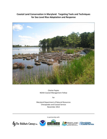
Coastal Land Conservation in Maryland: Targeting Tools and Techniquesfor Sea Level Rise Adaptation and ResponseChelsie PapiezNOAA Coastal Management FellowforMaryland Department of Natural ResourcesChesapeake and Coastal ServiceNovember 2012In partnership with:
For information or additional copies, please contact:Maryland Department of Natural ResourcesChesapeake and Coastal ServiceTawes State Office Bldg. E2Annapolis, MD 21401Or visitdnr.maryland.gov/ccpCatherine McCall cmccall@dnr.state.md.usToll free in Maryland: 1‐877‐620‐8DNR ext. 8737Out of state call: 410‐260‐8737TTY users call via the MD RelayMartin O’Malley, GovernorJohn R. Griffin, SecretaryThe facilities and services of the Maryland Department of Natural Resources are available to all without regard torace, color, religion, sex, sexual orientation, age, national origin or physical or mental disability.This document is available in alternative format upon request from a qualified individual with disabilityPrinted on recycled paperCover: Blackwater National Wildlife RefugePhoto: Chelsie Papiez, Maryland Department of Natural ResourcesPublication Number 10‐11722012‐610 Date of Print February 15, 20132
AcknowledgementsThis report is a final product of a 2‐year National Oceanic and Atmospheric Administration(NOAA) Coastal Management Fellowship, administered by the Coastal Services Center from2009‐2011. The project was supported with funds from NOAA and the State of Maryland.Additional financial assistance was provided by the Coastal Zone Management Act of 1972, asamended, administered by the Office of Ocean and Coastal Resource Management, NationalOceanic and Atmospheric Administration (NOAA) through Grants No. NA09NOS4190469,NA10NOS4190204, and NA11NOS4190151.This project would not have been possible without the support and technical assistanceprovided by George Edmonds, Towson University Center for GIS; Maryland DNR Advisory Group:Catherine McCall, Zoë Johnson, Christine Conn, Ph.D., Patricia Delgado, Ph.D., Erin McLaughlin,Lynn Davidson, and Dana Limpert; Coastal Land Conservation and Climate Change WorkshopDecember 2009 Attendees: Lamere Hennessee, MGS; Leslie Gerlich, USFWS; Chris Chambers,NOAA/NMFS/NEFSC; Kelly Collins, DNR; David Sutherland, USFWS/CBFO; Kate Boicourt, UMCES;Daniel Murphy, USFWS; David O’Brien, NOAA; Brian Needelman, UMD; Janet Cushing, USACEInstitute for Water Resources; Rina Aviram, NOAA/OCRM/CELCP; Nancy Cofer‐Shabica, NOAACSC; Mary Andrews, NOAA; Suzanne Baird, Blackwater NWR; David Burke, Burke EnvironmentalAssociates; Jeff Halka, Maryland Geologic Survey; Dana Limpert, MD DNR; Jacob Sobin, NOAA;Joel Dunn, The Conservation Fund; John Sherwell, MD DNR; Roxanne Thomas,NOAA/OCRM/CELCP; Doug Samson, The Nature Conservancy; Katie Theoharides, Defenders ofWildlife; Zoe Johnson, MD DNR, Catherine McCall, MD DNR; Paula Jasinski, NOAA ChesapeakeBay Office; Renee Thompson, USGS; Mark Bryer, The Nature Conservancy; VikramKrishnamurthy, Eastern Shore Land Conservancy; Roger Griffis, NOAA; Darlene Finch, NOAA CSC;and Climate Change Land Conservation Trainings through partnership with MarylandEnvironmental Trust and Defenders of Wildlife.Additional Support Provided by: Jonathan Clough, Warren Pinnacle Consulting, Inc.; Patty Glick,National Wildlife Federation; Maryland DNR GreenPrint Advisory Group; Jessie Cahoon,Maryland Environmental Service; Tim Palmer, Maryland Environmental Service; Kevin Coyne,Maryland DNR; Joseph Heckwolf, Maryland DNR; The Baldwin Group; Brian Needelman, Ph.D.University of Maryland; Gary Buell, USGS; NOAA Coastal Services: Lauren Long, Billy Brooks,Lindsay Goodwin, Nancy Cofer‐Shabica, Chrissa Waite, Margaret Allen, Keil Schmid, and NateHerold; Victoria Coles, University of Maryland Horn Point Laboratory; Gwen ShaughnessyMaryland DNR; Kelly Collins and Stacy Schaefer, Maryland DNR Land Acquisition and Planning;Gregory Pasternack, Ph.D. University of California Davis; Donald Cahoon, Ph.D. USGS; J. CourtStevenson, Ph.D. University of Maryland Horn Point Laboratory; Michael Kearney, Ph.D.,University of Maryland; Ralph Tiner, USFWS; Andrew Cruz, USFWS; Mitch Bergeson, USFWS;Denise Clearwater, MDE; Kelly Neff, MDE; Lamere Hennessee Maryland Geologic Survey; TheNature Conservancy; David Curson, Ph.D., Audubon Society; Beki Howey, MarylandEnvironmental Trust; Ann Gutierrez Carlson, Maryland Environmental Trust, and to everyoneelse who helped along the way.3
Table of ContentsIntroduction .5Background 7Implementation Overview .9Developing the Targeting Model .10Why Wetlands?.11Historic & Projected Wetland Responses .12Review of Wetland Models .13SLAMM 6 Methods & Parameter Setting .18Model Caveats .18SLAMM Results 19Developing Conservation Priorities 21State Conservation Targeting 25Moving Forward .26Impact 26Resource Links .27References .28Appendix A: SLAMM 6.01 Inputs by Study Extents 33Appendix B: SLAMM Results by Extent 38Appendix C: Land Conservation Model Matrix .56Appendix D: Maintaining Diversity of Wetland Classes .62Appendix E: Maryland’s Criteria For Coastal Land Conservation. . 63Appendix F: Maryland’s Companion Data Guide For Conservation .704
IntroductionThe iconic Chesapeake Bay, one of the largest and historically productive estuaries in the world,recognized by Native Americans as Tschiswapeki – great shellfish bay – is approachingpotentially unprecedented landscape changes due to compounded effects of increased coastalerosion, storm intensity and frequency, and sea level rise associated with climate change.Maryland has over 4,000 miles of coastline with the majority of the coastal zone 1 experiencingnaturally occurring land subsidence. Current estimates suggest that relative sea level rise isimpacting coastal lands at twice the global average rate. Over the last century relative sea levelin the Bay has risen one‐foot due primarily to land subsidence and global sea level rise. Risingwaters have contributed to the disappearance of 13 Bay islands. The low lying, sinking coastalareas make Maryland uniquely vulnerable to the effects of sea level rise. The sea level riseexhibited in the Chesapeake Bay over the past century is not purely eustatic rise but rather aresult of land subsidence. Land subsidence is caused by a variety of factors including:compression of surface sediment layers, isostatic rebound from the last glaciation, tectonicplate movement, groundwater extraction causing subsurface compaction, and depression ofcontinental margin by weight of sediment and seawater (Maryland Commission on ClimateChange 2008a, Figure 1).Figure 1: Relative sea‐level rise is a result of a combination of factors. Sea‐level rise isthe combination of the increase in volume of water as a result of global warming anddecrease in size of the ocean basins due to mid‐ocean ridge spreading. Land subsidenceis a consequence of various factors which result in the land surface sinking, reducingelevation. Sea‐level rise and land subsidence combine to result in relative sea‐level rise.1Maryland’s Coastal Zone includes all counties and municipalities that border the Chesapeake and Coastal Bays and the AtlanticOcean. There are 16 coastal counties (Baltimore, Anne Arundel, Prince George’s, Calvert, St. Mary’s, Charles, Howard, Cecil, QueenAnne’s Talbot, Caroline, Dorchester, Wicomico, Somerset, and Worcester) and Baltimore City covered under Maryland’s CoastalZone Management Program.5
Many of the islands lost played a role in Maryland’s maritime culture as year‐round residencesfor Chesapeake Bay watermen communities. Like island communities, many coastalcommunities in today’s landscape are being threatened by encroaching waters. Today there isonly one inhabited island left in Maryland’s portion of the Bay– Smith Island. The effects of sealevel rise have not only contributed to the loss of bay islands but also pose a threat toMaryland’s coastal systems.Research by the University of Maryland indicates that sea level rise may cause the loss ordegradation of up to 70% of the state’s tidal emergent marsh systems within the century(Kearney et. al., 2002). Noticeable losses may even become evident within 10 years. Currentlythe State of Maryland is losing 580 acres a year due to shoreline erosion, which will onlycontinue to exacerbate with projected sea level rise and extreme storms. Over the past century,coastal erosion contributed to a loss total of 18,000 hectares of coastal lands in the ChesapeakeBay (Wray et al., 1995).The effects of sea level rise on the landscape will likely vary throughout the Chesapeake Baydepending on wetland habitat, elevation, sediment capture and accretion rates. The mostvulnerable areas are on the eastern shore of Maryland where land has limited elevation reliefand current wetland degradation is already being witnessed. An example of this is the vastmarshes of Blackwater National Wildlife Refuge (Figure 2).Recognizing this problem,the Maryland Departmentof Natural Resources (DNR)released the report A SeaLevel Rise Response Strategyfor the State of Maryland(Johnson, 2000). Thispreliminary report reviewedthe sea level rise literatureand associated research,identified Maryland’svulnerability, and assessedMaryland’s existingresponse capabilities.In 2008, Maryland releasedanother strategy to addressthe impacts of sea level riseand coastal storms. TheComprehensive Strategy for Reducing Maryland’s Vulnerability to Climate Change was a keycomponent of Maryland’s Climate Action Plan (2008). Among other many otherrecommendations, the Strategy lays out key policy recommendations to proactively identify andprotect coastal habitat that will help mitigate interim impacts and provide long‐term adaptationpotential. In response to these key policy recommendations the Maryland DNR completed atargeting project that assessed the future location wetlands under predictive sea level risemodeling. From this modeling key conservation targeting criteria were developed that focusedFigure 2: Marsh breakup at Blackwater National Wildlife Refuge as relative sea levelrise pushes marshes to keep pace above sea level (Hennessee et al. 2004).6
on size, location and diversity of future wetland classes within Maryland’s coastal zone.Through this effort Maryland may be better able to protect coastal land and preserve distincthabitat, facilitate shoreline habitat retreat, mitigate coastal hazards, and reduce storm surgeimpacts.Developing these new criteria to target land acquisitions and conservation easements is acritical adaptation strategy for Maryland. In order to address these impacts, the Maryland DNRhas been developing new land conservation strategies to help preserve the long‐term survival ofcoastal wetlands that provide storm surge buffering to communities as well as critical habitat foraquatic and terrestrial species.BackgroundIn April, 2007 the Governor of Maryland signed the Executive Order 01.01.2007.07 thatestablished the Maryland Commission on Climate Change. The Commission was tasked todevelop a climate change action plan that assessed the regional drivers of climate change, likelyimpacts in Maryland, and adaptation options and goals. In August 2008, the Commissionreleased the “Climate Action Plan”. The Commission’s Adaptation and Response Working Groupwas charged with developing strategies and policy recommendations to reduce the vulnerabilityand increase the state’s resilience to climate change. The Adaptation & Response WorkingGroup produced Chapter Five of the Climate Action Plan, titled Comprehensive Strategy forReducing Maryland’s Vulnerability to Climate Change, Phase I: Sea Level Rise and CoastalStorms.The chapter details Maryland’s acute vulnerability to rising sea‐levels and proposed 19 policiesthat would enhance the state’s resilience to climate change. In the natural resource section ofthis chapter, guidance was given to “protect and restore the State’s natural shoreline and itsresources, including its tidal wetlands and marshes, vegetated buffers, and Bay islands, thatinherently shield MD’s shoreline and interior”. A suite of priority policy recommendations wereset forth to address this goal, two of which were used to directly guide this project: Identify high priority protection areas and strategically and cost‐effectively directprotection and restoration activities; andDevelop and implement a package of appropriate regulations, financial incentives, andeducational, outreach, and enforcement approaches to retain and expand forests andwetlands in areas suitable for long‐term survival.Recommendations from Maryland’s Climate Action Plan were the key drivers of this project andwere further supported by a previous wetland assessment report on Chesapeake and DelawareBays by the National Wildlife Federation. This report was based on the outcomes of SLAMMversion 5 modeling. The report outlined responses by government and non‐governmentdecision makers to: Prioritize project sites based one ecological importance as well as vulnerability to sea‐level rise;Expand restoration areas and coastal protection strategies to accommodate for habitatmigration; and7
Restore and protect a diverse array of habitat types to better support ecosystemfunctions and improve resiliency of fish and wildlife species.In the Climate Action Plan, the Scientific and Technical Working Group reviewed theIntergovernmental Panel on Climate Change (IPCC) Fourth Assessment Report (2007) along withadditional global sea‐level rise models, such as Rahmstorf (2007) and set forth sea level risescenarios for the Chesapeake Bay. The projections for Maryland are as follows: under a loweremissions scenario Maryland may experience up to 1.3 foot of rise by the year 2050 and 2.7 feetby 2100 and under a higher emission scenario it was estimated that 1.7 feet by 2050 and 3.4feet by 2100 (Figures 3 & 4).Figure 3: Sea level rise projections for the Chesapeake Bay based ongreenhouse gas emission scenarios. By mid‐century Maryland mayexperience up to 1.3 ft and, by the end of the century under acceleratedmelting relative sea‐level may rise 2.7 ft under lower emission scenarioto 3.4 ft under the higher emission scenario (MCCC, 2008).Figure 4: Rates of sea‐level rise in Chesapeake and Delaware Baysregion. Data are from tide gauges and the period of time theycover is in parentheses (MCCC, 2008).With these guiding policy recommendations and sea‐level rise projections, Maryland DNRundertook a 2‐year project to develop geospatial‐based evaluation criteria to help identify andtarget coastal lands that could help the State of Maryland adapt to climate change. As Marylandendeavors to adapt to climate change, the Climate Action Plan recommended that new data onclimate change vulnerability and adaptation opportunities, be added to the GreenPrint targetingtool. In December of 2008, Maryland launched a mapping tool called “GreenPrint” to prioritizelands for conservation across the state based on ecological data. GreenPrint uses geospatialsoftware to create color‐coded maps of information layers and aerial photographs to help landmanagers implement conservation strategies and identify land acquisition priorities.The GreenPrint tool has allowed the DNR to select ecologically valuable lands through thedesignation of Targeted Ecological Areas (TEAs) for conservation priority. By updating the8
designation of TEAs with climate change priority areas, GreenPrint will help Maryland makelong‐term conservation plans with future coastal conditions in mind. As a component of theproject, the climate change priority areas were added to the parcel‐level scorecard thatsystematically quantifies the adaptive benefits of a parcel of land relative to others.Implementation OverviewMaryland has been a leader in planning for the effects of climate change as evident by the 2000report on climate change response strategies (Johnson). When the Governor signed theExecutive Order creating the Commission on Climate Change, many agencies within Marylandwere already incorporating climate change into their work, easing the transition into the ClimateAction Plan.In May of 2009, the Department of Natural Resources Chesapeake and Coastal Service (CCS) wasawarded a NOAA Coastal Management Fellow. The NOAA Coastal Management fellow joinedMaryland DNR CCS in August 2009. Much of the work on identifying and creating a newgeospatial‐based targeting model for climate change adaptation was completed by the CoastalFellow (2009‐2011). The project was supported and funded by the Department of NaturalResources, Chesapeake and Coastal Service through the NOAA Coastal Zone Management Act of1972, and NOAA Coastal Services Center as part of the NOAA Coastal Management Program.In early 2010, during the planning stages of the targeting model, Maryland’s Board of PublicWorks, including the Governor, Comptroller and Treasurer requested that all parcels beingpursued for state conservation funding through Program Open Space be reviewed for climatechange vulnerability before the Board’s approval. To meet this request, a parcel‐levelevaluation form was developed to aid in the review of all pending state conservation easementsand acquisitions within the coastal zone. The evaluation form was developed to enable the DNRChesapeake and Coastal Service (CCS) to review all State conservation easements andacquisitions by evaluating site‐level attributes that support climate change adaptation, includingstorm surge abatement and resiliency; mitigation and restoration opportunities that wouldincrease the viability of coastal ecosystems and/or the carbon sequestration of the site; andfuture human ecology 2 attributes. Reviews were completed on a project‐by‐project basis usingspatial data and geospatial mapping tools, including ArcGIS 9.2 and Maryland’s Coastal Atlas.The original evaluation form was updated after the completion of the climate change adaptationmodel to incorporate key components of the identified wetland adaptation areas and wetlandmigration corridors. The evaluation form continues to be used for stewardship review– an inter‐agency review process required for any parcel of land being considered for state conservationfunds. A working version of the Climate Change evaluation form and supporting data guide canbe downloaded from DNR’s Chesapeake and Coastal Service’s project webpage. 3In addition, Maryland DNR Coastal Program developed training materials to help other agenciesand non‐governmental organizations incorporate climate change into their land conservation2Human Ecology describes connections between people and the world around them. The right land conservation projects can buildbridges between human well‐being and natural areas giving people the opportunity to understand the value of land, experience itsbeauty, empower their communities, heal its wounds and become healthier in the process.3Maryland’s Evaluation Criteria For Coastal Land Conservation: In Response to Climate Change Impacts of Sea Level Risehttp://www.dnr.state.md.us/CCS/pdfs/MDCCSEForm July2011.pdfMaryland’s Companion Data Guide For Conservation: Climate Change Data Layers for Parcel Level DataGuide July2011.pdf9
and restoration targeting and review processes. A pilot training was held with MarylandEnvironmental Trust (MET) regional planners on January 13, 2011. Following the initialscreening and feedback from MET, DNR CP co‐hosted a training with MET and Defenders ofWildlife on June 30, 2011 which focused on the application of DNR’s new climate change dataand use of Coastal Atlas as a tool for land trusts working in Maryland’s coastal zone.Developing the Targeting ModelPrior to developing the targeting model, a literature review was carried out to select a suite ofexisting recommendations on climate change adaptation strategies for coastal areas. Specificadaptation strategies were identified to help address climate change responses for the followingresource sectors: Aquatic & Terrestrial Ecosystems, Transportation & Land Use, Human Habitat& Health, Resource Based Industries, and Agriculture. These strategies were presented during aDecember 2009 workshop entitled, “Coastal Land Conservation and Climate Change” organizedand co‐hosted by NOAA Fisheries Office of Habitat Conservation, NOAA Coastal Services Centerand Maryland DNR. The goals of the workshop were to: identify and prioritize climate changeadaptation strategies in the context of coastal land conservation; develop criteria for evaluatingand targeting on‐the‐ground implementation of climate change adaptation strategies throughcoastal land conservation practices; and, identify data sources supportive of the identifiedcriteria. The recommended adaptation strategies and criteria from the workshop were furtherdeveloped and added to the project as new evaluation criteria for land acquisitions. All of theworkshop materials, including the recommended criteria are available for download onMaryland’s Chesapeake and Coastal Service website. 4One of the most important criteria identified at the December workshop was to identify ameans in which to help facilitate landward movement of coastal wetlands subject to dislocationby sea level rise. This was identified as cross‐cutting criteria that would benefit all sectors havingapplication for adaptation responses to sea level rise. The potential loss of ecological functionscoastal wetlands provide would affect all sectors through the loss of storm surge abatement,wildlife habitat, flood management and control, water quality, to name a few.4Maryland Department of Natural Resources, Chesapeake and Coastal Service http://www.dnr.state.md.us/CCS/habitats slr.asp10
Ben Fertig, Integration and Application Network, University of Maryland Center for Environmental Science (ian.umces.edu/imagelibrary/ )Jug Bay Wetlands Sanctuary, Chesapeake Bay National Estuarine ResearchReserve in MarylandWhy Wetlands?Wetlands provide critical ecosystem benefits around the world and play a significant role inMaryland’s coastal ecosystem. Maryland’s rich maritime culture is dependent on the nurseryand rearing habitat wetlands provide, not to mention, wetlands help create the aesthetic beautythat makes the Chesapeake Bay unique. Wetlands provide valuable benefits that, if given theopportunity may continue to be provided into the future under sea level rise conditions.In order to maintain coastal wetlands under sea level rise conditions, wetlands must accrete at afaster or equal rate of sea level rise, have a positive elevation gradient inland, and have limitedbarriers such as hardened shorelines or other impervious surfaces inland from their currentexistence. Wetland migration corridors make up some of the most important areas for coastaladaptation in response to sea level rise. These areas are designated by forecasting wherewetlands may establish inland as sea levels rise, often in areas currently designated as non‐wetland hydric soils. Maintaining areas for wetland migration may provide opportunity forinland retreat of Maryland’s coastal and nearshore wetlands that provide a variety of ecosystemservices such as, wildlife habitat, water quality improvement, storm surge abatement, floodmitigation, aquifer recharge, carbon sequestration, erosion control, recreation and potentiallygroundwater recharge.Maryland has roughly 600,000 acres of vegetated wetlands (9.5% of state’s land surface) ofwhich palustrine or freshwater wetlands make up 342,626 acres (88.7% are non‐tidal) and251,542 acres of estuarine wetlands or salt and brackish wetlands (Clearwater, et al. 2000).Maryland’s coastal wetlands provide important habitat, shoreline stabilization, carbon storage,storm surge buffers, and nutrient filtration, among many other benefits.11
“ tidal freshwater marshes are critical buffers protecting estuarine and coastal waters fromsediments, nutrients, and toxics derived from deleterious upland human activities and land use”(Pasternack & Brush, 1998)As sea levels rise, coastal marshes may be able to migrate inland through the trapping ofsediment and the buildup of organic matter. Coastal wetlands form in areas of sedimentation,and in Maryland many of the vast wetland networks have developed along tidal rivers andestuarine embayments, such as the Choptank, Chester, Patuxent, Potomac, and NanticokeRivers (Tiner, R.W. and D.G. Burke, 1995). As mentioned, wetland migration is dependent onmultiple factors including a positive elevation gradient or slope inland, sediment supply, limitedimpervious barriers and intact habitat corridors to name a few. Preserving intact coastalcorridors for marsh migration is an adaptive approach to address the environmental impacts ofsea level rise associated with climate change. It has been estimated that almost 60% of the low‐lying land along the U.S. Atlantic coastline is expected to be developed and thus unavailable forthe inland migration of coastal wetlands (Titus et al., 2009).Historic and Projected Wetland ResponseDuring the end of the last glacial period, the Pleistocene epoch that occurred more then 15,000years ago, there was a period of rapid eustatic sea level rise that lasted around 4,000‐5,000years as the Pleistocene glaciers melted. The northern ice sheet called the Laurentide camedown to 37 degrees latitude, around Pennsylvania border and reached thickness in some areasas much as 8‐10,000 feet or more. The weight and mass of the glacier was “sufficient to deformthe earth’s crust. The mantle material beneath that part of the crust was forced to moveoutwards forming a bulge around the periphery of the ice sheet” (NOAA CSC, 2000).After the retreat of the glaciers, the land started a post glacial rebound adding to the rate ofrelative sea level rise in Maryland and around the Chesapeake Bay. This gradual sinking or landsubsidence, in addition to global sea level rise is called relative sea level rise. After the lastglacial period and “sea level rise slowed to near zero, but has continued gradually throughout,creating conditions favorable for marsh development and long‐term accretion at rates equalingor exceeding sea level rise” (Titus, 1987 cited Emery and Uchupi 1972; Redfield 1972; Davis1985). Around 3,000 to 4,000 years ago, coastal wetlands stabilized with sea level (Tiner, R.W.and D.G. Burke, 1995).As sea levels rise in response to global climate change, coastal wetlands will likely be threatenedby submergence in the coastal zone. Non‐tidal wetlands may become tidally influenced andfreshwater systems may convert in to a more saline environment. Forest vegetation will slowlybe replaced by salt‐tolerant marsh plants. Though the timeframe for this soil conversion isestimated at 180 35 years, and with the current rate of sea level rise this timeframe is reducedby 63% (Hussein, 2009) there may still be a chance for wetlands to respond if conditions areright. Coastal marsh soils may be maintained as low‐lying forest soils (ultisols) becomeinundated by rising water, they may convert to marsh soils over time (histosols) (Hussein, 2009).The inland wetlands established during the Pleistocene epoch will be critical areas for theretreat and establishment of coastal wetlands (Titus, 1987). Rising water tables associated withsea level rise will likely expand existing freshwater systems, further establishing a migrationcorridor and suitable soils for the inland migration of coastal wetlands.12
In response, long‐term planning for coastal adaptation should include the protection of wetlandcorridors to help facilitate the movement of important coastal wetlands inland as they attemptto keep pace with rising waters. In order to proactively respond, wetland modeling with sealevel rise was a major component of this project. Predictive results were used to identify areaswith the most potential for wetland migration corridors and new wetland areas that can be usedto target wetland restoration and conservation activities.Review of Wetland ModelsIn order to address the adaptation responses identified by the December workshop and developa new targeting model for wetland corridors, wetland models were examined for thedevelopment of data that could help indicate where wetland migration, loss, and transition mayoccur in the future under sea level rise conditions.For decades researchers have studied and modeled wetland response to sea level rise to assesslong‐term and short‐term vulnerability of our dynamic coastal systems. To be able to assess thelikelihood of future wetland migration corridors, DNR explored the marsh models available forlandscape scale projections. There are additional hydrodynamic models that can be used at thesite scale with site specific data, but the extensive data needed for this, and the time intensity ofcompleting a site specific study around the Chesapeake Bay were limiting factors for a two‐yearstudy.As a result the fellow researched reviewed two landscape scale wetland models for addressingthe project criterion – to help facilitate landward movement of coastal wetlands subject todislocation by sea level rise. One model wa
Toll free in Maryland: 1‐877‐620‐8DNR ext. 8737 . has been developing new land conservation strategies to help preserve the long‐term survival of coastal wetlands that provide storm surge buffering to communities as well as critical habitat for . inherently shield MD’