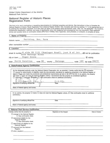
Transcription
OMS No. 10024-0018NPS Form 10-900(Oct. 1990)United States Department of the interiorNational Park ServiceThis form is for use in nominating or requesting determinations for individual properties and districts. See instructions in How to Complete theNational Register of Historic Places Registration Form (National Register Bulletin 16A). Complete each item by marking "x" in the appropriate box orby entering the information requested. If an item does not apply to the property being documented, enter "N/A" for "not applicable." For functions,architectural classification, materials, and areas of significance, enter only categories and subcategories from the instructions. Place additionalentries and narrative items on continuation sheets (NPS Form 10-900a). Use a typewriter, word processor, or computer, to complete all items.Farth ing, Ben, Farmhistoric nameother names/site number street & number W sid eS R 1121 ( Rom in g erR ad), jus t N of JetTJ,laI not for publicationwith Watauga Rivercity or town S t l.::::g:-a r G r o v e vicinitystate l' T o r t h C a r o l i T la code county W a t a t l.;:.g a code zip code 28679As the designated authority under the National Historic Preservation Act, as amended, I hereby certify that this Iil nominationrequest for determination of eligibility meets the documentation standards for registering properties in the National Register ofHistoric Places and meets the procedural and professional requirements set forth in 36 CFR Part 60. In my opinion, the property[il meets 0 does not meet the National Re ster criteria. I recommend that this property be considered significantnatjonal 'II 0 statewideca. (0 S e continuation sheet for additional comments.)oo\". .Signature of certifying oHiciallntlDateState of Federal agency and bureauIn my opinion, the propertycomments.)0meets9ignature of certifying officiallTitie0does not meet the National Register criteria.(0See continuation sheet for additionalDateState or Federal agency and bureauI hereby certifytha the property is:o entered in the National Register.o See continuation sheet.o determined eligible for theNational RegisterSee continuation sheet.oo determined not eligible for theNational Register.o removed from the NationalRegister.o other, (explain:)Signature of the KeeperDate of Action
Ben Farthing FarmWatauga County.Name of Property, . . ,. "", . 1",,,1 .ofNCCounty and State1IJ1I'8'\n,a,II""IhJrotJI:U"llIf'H"\8(Check as many boxes as apply)IX] privateo public-localo public-Stateo public-FederalofNumber of1IJ1I'1f'\n,a.1n"\1oneo building{s)o siteo structureo objectQ9 districtwithinLl1I'8'\ IF\ I.1Ph ,(Do not include previously listoo resourcesContributingcount.}Noncontributing6 2 buildingssitesstructuresobjects 6 !:::2'Name of related multiple property listing(Enter "N/A" if property is not part of a multiple property listing.)TotalNumber of contributing resources previously listedin the National RegisterN/A-0-Historic FunctionsCurrent Functions(Enter categories from instructions)(Enter categories from instructions)DOMESTIC: Single dwellingAGRICULTURE/SUBSISTENCE:agricultural outbuildingDOMESTIC: multiple dwellingAGRICULTURE/SUBSISTENCE:agricultural outbuildingagricultural fieldsLANDSCAPE: street· furniture/objectagricultural fieldsLANDSCAPE: street furniture/objectnatural featurenatural ·featureforestArchitectural ClassificationMaterials(Enter categories from instructions)(Enter categories from instructions)Other:foundationFrame gambrel banked barnBungalow/Craftsman.!:s t o.!.!n:.::e::.-walls w e a t h e r b o a r droofme talotherwoodasphalt shingleNarrative Description(Describe the historic and current condition of the property on one or more continuation sheets.)
Watauga Co., NCBen Farthing FarmCounty and StateName of PropertyApplicable National Register Criteria"Areas of(Mark "x" in one or more boxes for the criteria qualifying the propertyfor National Register listing.)(Enterfrom instructions)Agriculture:B:: A Property is associated with events that have madea significant contribution to the broad patterns ofour history.oB Property is associated with the lives of personssignificant in our past.C C Property embodies the distinctive characteristicsof a type, period, or method of construction orrepresents the work of a master, or possesseshigh artistic values, or represents a significant anddistinguishable entity whose components lackindividual distinction.o0Period of Significance1935-1942Property has yielded, or is likely to yield,information important in prehistory or history.Criteria Considerations(Mark "x" in all the boxes that apply.)Significant Dates1935Property is:1938o1939A owned by a religious institution or -used forreligious purposes.oB removed from its original location.1941Significant Person(Complete if Criterion B is marked above)N/ADCa birthplace or grave.oCultural Affiliation0 a cemetery.oEN/Aa reconstructed building, object, or structure.oF a commemorative property.oG less than 50 years of age or achieved significancewithin the past 50 years.Architect/BuilderFarthing, BenI Iartley, Cha rlesNarrative Statement of Significance(Explain the significance of the property on one or more continuation sheets.)Bibilography (Cite the books, articles, and other sources used in preparing this form on one or more continuation sheets.)Previous documentation on file (NPS):oooopreliminary determination of individual listing (36CFR 67) has been requestedpreviously listed in the National Registerpreviously determined eligible by the NationalRegisterdesignated a National Historic Landmarkrecorded by Historic American Buildings Surveyo'#---------------o recorded by Historic American EngineeringRecord #Primary location of additional data: State Historic Preservation OHice0 Other State agency .0 Federal agency0 Local governmentCJ University0 OtherName of repository:
Watauga Co., NCBen Farthing FarmCounty and StateName of PropertyAcreage of Property a p pro xi. mat ely16 a ere sUTM References(Place additional UTM references on a continuation sheet.)1412,sIE,3 01 14 P 11 ,0 I 6 , 0,011q 1 2,6 12I3I4NorthingEasting,7 ,0 1 I( ,0 11 , 01 7,4 ,0llLZJ III 12 I 61 I ,9 10 I 14 1 1 1 1 15 I ,0 IEastingZoneNorthingllLZJ 1412 ,5 16 ,7 , I 14 I 01 1 1 14 I 5,0 I1o See continuation sheetVerbal Boundary Description(Describe the boundaries of the property on a continuation sheet.)Boundary Justification(Explain why the boundaries were selected on a continuation sheet.)name/title ---1-1.:a2.uD.e,g.l.l.dl.lo.uD E.I.Lo.!.O-Lpf-4Lplo .erUm.l.J.Lla.uD.uD street & number1500 Overbrook Avenuecity or town--!.W!.!i'-'!.!n st o n!.- Sa I e m.!. 'dateAugust, 1992telephonestateNC919021-1949zip code 27.!.-'1 O:.!.4Continuation SheetsMapsA USGS map (7.5 or 15 minute series) indicating the property's location.A Sketch map for historic districts and properties having large acreage or numerous resources.PhotographsRepresentative black and white photographs of the property.Additional items(Check with the SHPO or FPO for any additional items)namestreet & number telephonecity or townstatezip codePaperwork Reduction 'Act Statement: This information is being collected for applications to the National Register of Historic Places to nominateproperties for listing or determine eligibility for listing, to list properties, and to amend existing listings. Response to this request is required to obtaina benefit in accordance with the National Historic Preservation Act, as amended (16 U.S.C. 470 at seq.).Estimated Burden Statement: Public reporting burden for this form is estimated to average 18.1 hours per response including time for reviewinginstructions, gathering and maintaining data, and completing and reviewing the form. Direct comments regarding this burden estimate or any aspectof this form to the Chief, Administrative Services Division, National Park Service, P.O. Box 37127, Washington, DC 20013-7127; and the Office ofManagement and Budget, Paperwork Reductions Projects (1024-0018), Washing1on, DC 20503.
number-.: The Ben Farthing Farm is a picturesque rural property located in the steep mountains and fertilebottomlands of the Sugar Grove community in northwest Watauga County, North Carolina. Situated onthe north bank of the Watauga River at the junction of Cove Creek, the farmstead consists of a modestone-and-one-half story frame bungalow of the early 1920s, a large 1930s frame barn of traditionalgambrel-roof form, a 1930s root cellar built into a mountainside, a 1930s frame outhouse, and an early1940s frame scale house for weighing lambs, ewes and cattle at selling time. It also retains a significantvernacular landscape of rock walls, walkways and steps. This complex is surrounded by woodland,pastureland, and tillable bottomland which served the farm during its period of significance (1935 to1942). This agrarian and forested terrain is an integral part of the landscape which still today conveysthe isolated visual character typical of this mountain region. The building complex is clustered on thesouthern edge of Beaverdam Ridge with the house on a small plateau overlooking the Watauga Rivertowards mountains in the distance. A curving drive climbs the mountain past the scale house and pondto reach the tightly-nestled collection of barns, house, and outbuildings. To the north and particularlywest of the house is the farm complex, built into and around the steep hillsides and making ben ficialuse of this topography to ease the work of the farm. Just as the bank barns accommodate tile steepterrain into which they are built, the Farthings' rockwork harmonizes with it, creating steps down hillsfrom the house to the road, to other buildings and to the garden; retaining walls along the garden'sedge, near the barn, and around the graded lawn of the house; and level rQck pathways. Near thebuildings were the family gardens for food and flowers and farther north and uphill were the cattle andsheep pastures. To the east in the bottomlands along Cove Creek were planted three acres of corn; onthe steepest lands grew hardwoods, mainly oak, locust, and maple.The Farthing Farm with its setting in an historic landscape possesses integrity of location, setting,design, materials, workmanship, feeling and association. :The house has been divided and is now rentedas duplex apartments, and some of the pastureland not included in the nominated area has been plantedfor the last twenty years in white pine. Still the land and buildings are in good repair and convey thesense of family farm life and livestock farming in this mountain region in the early part of the twentiethcentury. The essential integrity of the farmhouse, of the pre-1943 farm utbuildings, of the remarkablyintact vernacular rock landscaping, and of the undisturbed mountain setting has not been compromised.According to members of the Farthing family, there were at least three other outbuildings on theproperty which no longer exist. These included a chicken house and a pig pen, both built before theFarthings purchased the land in 1932 and demolished in 1978 because they were in deterioratedcondition. A third building demolished in 1978 was a sheep barn, located just below the farm pond andharmed significantly when the pond dam broke, damaging the barn's foundation. The loss of thesebuildings and the presence of two post-1942 outbuildings do not detract from the integrity of thecomplex.The elements of the nominated area include:A. Designed Landscape Features, designed and built 1939, (C).On the farm is significant vernacular landscaping of native rock, designed by Ben Farthing and builtmainly by his children under his direction while he was in poor health, with the majority of the
number2Ben Farthing FarmWatau a County, NCcollecting and carrying of the rocks done by his children. The impressive work remains in remarkablyintact condition tOday. Flat stone walkways lead from the driveway to the house and from the kitchento the edge of the barnyard. Stone steps climb to the front porch of the house, from the side lawn tothe garden, and up a steep hill to the second floor of the cellar behind the house. A long stonestaircase from the front of the house climbs down a steep incline to the road. Stone walls were alsobuilt to create a terrace between the garden and root cellar and the back of the house, and a stoneretaining wall supports the driveway as it approaches the barn from the north.B. Ward-Farthing House, built in 1923, (C).The house is the oldest building on the Farthing Farm. Built by Charlie Hartley, a local builder, forthe owner Walter L. Ward and his family, it illustrates the transition in .Watauga County as elsewherefrom more indigenous house types to the popular national bungalow style. The house is a typical oneand one-half story frame bungalow of its period. Covered in weatherboards, its roof is side-gabled andof standing-seam metal, with false knee braces at the gable ends. The roof was originally covered withchestnut shingles; the metal was applied during the 1978 repairs. An attached shed porch extends acrossthe entire front, supported by four square posts, and wraps to the left, or west, side. The front porchremains open while the side porch has been screened, retaining its posts. The first-story facagedivided into five bays with a central entrance; a side door enters the house from the side porch.Windows are one-over-one throughout. On the front elevation is a broad shed dormer with three baysof paired windows, exposed rafter ends on the front, and false knee braces .at each side corner. There isno dormer on the rear. The house measures 30 by 48 feet overall including the porch. Reflecting itsmountain setting, the house rests on a stone foundation and a broad rock step leads from the stonewalkway to the central entrance of the front porch. From the porch is a stunning view to the south,across the river valley below to the mountains in the distance.isThe interior of the house is simple, even less adorned than the exterior. Most of the interior walls andceilings are sheathed with beaded tongue-and-groove siding. An enclosed stair is just to the side of thefront entrance door in an entrance room with fireplace on the west wall with unadorned brick chimneybreast. The house was heated with a central chimney with fireplace opening on either side, both nowclosed, and a flue in the rear serving the kitchen. Door and window surrounds are plain. Downstairsrooms include a living room, dining room, kitchen, bath ·area (added in i939 when interior plumbingwas installed), and two bedrooms.The second story of the Ward-Farthing House was unfinished when the Farthings purchased it in 1938,and was completed in that year and the next creating three bedrooms with closets, a storeroom, and alarge hall. A typical and simple square newel and rail are found around the stair opening on thesecond floor. The beaded sheathing of the second floor is slightly wider than that of the first floor.Most of the first floor sheathing has been painted, while that of the second floor remains unpainted.Doors on the second floor, also unpainted, are two-panel and five-panel. Surprisingly, the second floorwas not heated. Instead, a rectangular panel opens in the ceiling of the first floor just in front of thefireplace, allowing heat to pass up into the sleeping area above.In 1978 the house was converted into a duplex with six rooms on both levels of the right, or east side,in one residence using the front door as its entrance. The other side has three rooms, a storeroom anda bath, and uses the side porch door as its entrance. Doors were closed to create the division between
number --.;.Ben Farthing FarmWatau a County, NCliving spaces; no new partitions were created. Although a second small kitchen was added, the exteriorof the house was not affected and the adaptation to a duplex was made without compromising theintegrity of the house. The building is in good condition.Outbuildings remaining with the Farthing Farm are positioned close to one another north and west ofthe house and arranged as dictated by the mountainous terrain:C. Agricultural Landscape, from 1935, (C).Another integral part of the landscape is the agrarian and forested terrain which still today conveys theisolated visual character typical of this mountain region. To the north and particularly west of thehouse is the farm complex, built into and around the steep hillsides and, making beneficial use of thistopography to ease the work of the farm. Above the house were two springs, their waters routed into asingle receiving tank in 1938 and water pipes built to carry the water down to the farm and housecomplex. 1 Below and north of the 1935 barn is the farm pond, built in 1938 or 1939 for watering thepastured livestock and fed by the overflow from the springs' reservoir up the mountain. The pond isstill used today for fishing. 2 The cattle and sheep pastures hugged the mountain north of the bui dings.These are not included in the nominated area because they have been planted in white pines ,since theearly 1970s and no longer reflect the pasture patterns present during the Farthings' use of the land as aworking livestock farm. In the 1940s Mr. Farthing had planted pines to the southwest and southeast ofthe building complex on lands thought to be too steep for pasture. These ,are included in thenomina ted area.D. Barn, built 1935, (C).The large frame barn, with stone foundation and gambrel roof, was built in 1935 by Ben Farthing andhelpers for animals, hay and grain. 3 The gambrel roof, with steep flowing sides, was originally coveredwith chestnut shingles but is now standing-seam metal. The barn was built into a hillside to providedirect access at both levels. Consequently, the east gambrel end appears to be one story but accessesthe second level of the barn. This elevation is covered with diagonal Siding except for the lower southportion which is sided with spaced horizontal slats to provide air to the corn crib. Small slats at thepeak of the gambrel above repeat the diagonal pattern of the barn siding. The original door andwindow openings remain in this elevation, although the door itself is a replacement.The south elevation is also patterned with diagonal siding, meeting at a batten door with a small fourlight sash to the west. Farther east on this elevation is a large batten wood door hung on a slidingmetal track; this provides vehicular and animal access to the lower level of the barn.The west gambrel end shows the full height of the barn, as it is on the downhill side. Again, the barnis diagonally sided with the "V" meeting in the middle. Three batten doors are spaced symmetrically;1 The receiving tank is north of the nominated area.2Personal interview with Dr. Frances M. Farthing.3 Study List application, also personal interview with Dr. Frances M. Farthing, daughter of Ben Farthing and part owner.
each opens to a cow stall and has rectangular openings for air and light on each side. The "Z" patternof the battens is reversed in the central door, probably for symmetry.The north elevation is similar to the others in its diagonal siding meeting in a "V," but has no humanaccess door as found in the south elevation. It does, however, have the large doorway for vehicularaccess. The batten door has been removed and is stored inside. At the northeast corner of the barn,cinder-block buttresses have been built to support the rock retaining wall at the driveway.Inside on the lower level are three cow stalls on the west end, each with an opening to the exterior, andhorse stables across an aisle. Feeding troughs remain in the stalls. A feed storage area is also on thefirst floor next to a wooden staircase leading to the hayloft above. Extending across the south end ofthis level, beneath the corn crib, is an enclosed area used for shearing of sheep, butchering of animals,storing of farm machinery and harnessing of the horses. 4 On the upper level, a large hayloft extendsover the entire first floor with the exception of the corn crib in the southeast corner. Between thelevels are shoots for dropping hay and grain from the storage loft above to the animals below. Theupper level was accessible from the east by trucks, wagons and sleds for loading and unloading of ,hayinto the loft and corn into the crib. The building is in good repair; the northeast corner of tb.e secondlevel has been curtained off and a simple half-bath and plumbing added with virtually no affect on theintegrity of the structure. The rest is remarkably unchanged and used for incidental storage.E. Root Cellar, built 1938, (C).The cellar is located just behind the farmhouse and built into a steep mountainside. Built by Mr.Farthing when his family moved to the farm, again with help, this building is a tall, narrow gable-roofedstructure of cement construction on the first floor and weatherboarded frame construction on thesecond. Decorative chestnut shingles in the upper gable ends are the only ornamentation. A thickwooden door opens to the cement lower level with cement floor. This level was used to store cannedmeat, vegetables, fruits, pickles and other summer products. Built-in wooden bins held potatoes, apples,and onions, but the cellar was too damp for storing gladioli and dahlia bulbs. Access to the secondfloor is up a steep rock staircase along the west side of the building to a four-panel door, apparentlyreused from an earlier building, with plain surrounds. This level of the c.ellar has a wooden floor andrough-board walls and was used for curing meat for home use. Hooks remain in the rafters. Thebuilding is in good repair and is used for incidental storage today.F. Outhouse, built 1938, (C).This small building is of frame construction with a shingled shed roof, measuring six by six-and-one-halffeet. The outhouse is sided with unpainted vertical boards and has a batten door. An earlier outhousein the same location was demolished and replaced by this one under a government program. Thebuilding was repaired and moved ca. 1978 from its original location nearer the house to its currentlocation in the garden field and is now used for storage of garden tools.G. Scale House, built 1941, (C).This plain frame structure was built by Ben Farthing and his father, William Farthing, to hold cattle4 Frances Farthing write-up for Study List application, and personal interview.
number Ben Farthing FarmWatau a County, NCscales and provide for the annual weighing of lambs, ewes, and cattle at selling time. This was the onlyscale house in the area and served livestock farmers from the surrounding community.s Roofed with astanding-seam metal gable roof, the building has large openings at each gable end to allow for livestockto be brought in at the north end, weighed, and taken out at the south end. A smaller doorway forpeople is at the east elevation. The building is located with its long axis parallel to the hillside to allowfor level entrance and exit. The building is at a lower elevation than the rest of the farm complex andlocated just west of the entrance drive to the farm, providing easy access for farmers and buyers whocame to use the scales. (The entrance drive was relocated slightly east in the 1980s to help alleviateerosion problems. The scale house is west of both the original and current driveway locations.) Thescales have been removed and are stored by the family; the building is vacant but in stable condition,and surrounding growth is kept under control.H. Dairy Barn, built 1949, (NC).Built by Ben Farthing and helpers to serve a dairy operation which was begun on the farm in 1949when one of Farthing's sons returned. Dairy functions dictated modifications to traditional frameconstruction: the first level is of cement and the second level of wood. The building is covered ith anasphalt-shingled gambrel roof. Its north/south axis leaves access to both ends of the building ,at asimilar level, while it is the sides of the building which meet the hillside at different levels. (Thereverse is true for the 1935 barn.) The first floor was used for milking, feeding, washing of milk cans,and feed storage. The wooden second floor was used for grading of tobacc,o and storage. This buildingwas converted into a residence in 1984. Wooden entrance steps and a small deck have been added tothe upper level on the east elevation and a roof has been added to the cement porch on the westelevation's first level.I. Woodshed, built 1949, (NC).This is a simple cinder block building, one story with attic beneath a standing-seam metal gable roof. Itwas constructed to replace an earlier frame woodshed which was removed the same year for constructionof the dairy barn. It is in good condition.5 Frances Farthing write-up for Study List application, and personal interview.
The Ben Farthing Farm is a significant representative of the predominance of agriculture in WataugaCounty in the second quarter of the twentieth century. The farm's setting on the north bank of theWatauga River and at the mouth of Cove Creek includes both mountainous terrain and bottomland.Historically the farm property has consisted of a mix of woodland, pasture, garden, the building complex,and cultivated bottomland. The Farthing Farm contains buildings associated with twentieth-centurymountain farm living and livestock farming, including a large frame banked barn, a banked root cellarwith space for dry storage above, and an unusual scale house, used for weighing cattle and sheep andthought to be the only example of its type in Watauga County. The farm also retains a significantdesigned vernacular landscape of rock work, including impressive stone walkways and steps on both flatareas and steep inclines. These are important as a part of the setting utilizing indigenous materials.The complex was created by Ben Farthing and his family, who bought the property in 1932, built a largebarn in 1935, moved into the existing farmhouse in 1938 and immediately built several outbuildings andthe rock work. The farm, with its buildings and rock landscaping, together with the steep ten:ain andwooded ridges, presents an agricultural landscape that is rapidly becoming a rarity in Watauga County as. in much of the mountainous regions of North Carolina. This farm is the most intact twentieth-centuryfarm in the area, where such farms are disappearing due to development a d the difficulty of making aliving on mountain farmland. The property began to take on its present appearance in the mid-1930swhen the Farthings developed it as their farm, beginning with the construction in 1935 of the largebanked barn. Thus the period of significance extends from 1935 to 1942, which complies with the fiftyyear guideline for nominations. The boundaries include approximately sixteen acres which represent thearea retaining the farm's historic integrity. The west, south, and east boundary lines follow the propertylines, while the irregular northern boundary follows the tree line separating historic pastureland fromwhite pines planted in 1971 on lands previously used as pasture.Agricultural ContextThroughout the nineteenth and continuing after the first ·half of the twentieth century, farming was byfar the chief land use and source of income in Watauga County. Although the percentages of landdevoted to farming decreased in the twentieth century, they remained high. Almost 100 percent of thecounty's land area was in farms in 1910; thirty years later it was still relatively high at 79 percent,compared to 72 percent for the entire state in 1910 and 60 percent in 1940. 6 During the same periodthe number of farms increased, indicating a reduction in the size of farms.7 Mostfarms in the county,including the Farthing Farm, were between 20 and 100 acres. This remained true throughout the periodof significance. 86Agricultural Schedules, 1910, 1920, 1930, 1940 census records.7From 2,332 farms in 1900, up to 2,696 in 1940. Figures Ibid.8Agricultural Schedules, 1910-1940 census records.
numberWhile the number of cattle on the farms of Watauga County declined each decade from 1910 to 1930,their value increased from under 275,000 in 1910 to 498,000 in 1930. Similarly, the number of sheepdeclined from 13,500 in 1910 to 9,300 in 1930, but the value of those sheep increased from 61,000 toalmost 135,000 during the same twenty years. 9 The number of sheep shorn for wool reflects thenumbers above, with 7,213 sheep shorn on 540 farms in 1930, producing over 39,400 pounds of wool ata value of over 15,700. 10Few early twentieth-century Watauga County farms were specialized. Commercial farming did not beginin the county until after 1900, and not to any great extent until after 1920,11 Most farms were classifiedas "self-sufficing" farms in the 1930 census records. Just under a fourth were "general farms," and amere 4.5 percent were "animal-specialty" farms. The more specialized classifications, such as poultryfarm, cash-grain farm, fruit farm, cotton farm, or dairy farm, either did not exist in the county at thattime (e.g. there were no cotton farms) or were represented by only a very few farms there (e.g. fruitfarms). Thus the Farthing Farm, which was self-sufficing and concentrating on livestock for income, isrepresentative of the county during that period. The Farthings, like others in the area, were self-,sufficient in vegetables, meat, and fruit, as well as feed for their livestock. According to family tradition,only coffee, sugar, and salt were bought at the storeYAs Ben Farthing's daughter states, "On most mountain farms the owners were involved in a number ofactivities, all contributing to the success of the venture. A few cattle and sheep--pasture, hay and grainfor the animals--
edge, near the barn, and around the graded lawn of the house; and level rQck pathways. Near the buildings were the family gardens for food and flowers and farther north and uphill were the cattle and sheep pastures. To the east in the bottomla
