Transcription
F.S.A. de ClercqTernateThe Residency and Its Sultanate(Bijdragen tot de kennis der Residentie Ternate, 1890)Translated from the Dutchby Paul Michael Taylor and Marie N. RichardsSmithsonian Institution Libraries Digital EditionWashington, D.C., 1999
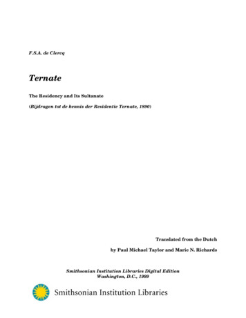
TERNATEiMap of the Capital Ternate*Scale 1:12500Key: 1) Coal warehouse; 2) Kadatu Todore;** 3) Residency office; 4) Jetty; 5) Jail; 6)Harbor office; 7) Resident’s house; 8-9) Engine houses; 10) Club; 11) European school; 12)Pasar; 13) Civil army magazine; 14) Public Works Department shed; 15) Protestant church;16) Chinese temple; 17) Native school; 18) Military canteen; 19) Slave graveyard.*[Translator’s note: Other place names appearing on the map, but not in the captions, arelisted below. Updated Malay or Ternatese spellings, where different from spellings shown,are shown as translations. If the term is a proper name, with no spelling updatingrequired, it is not translated as, for example, Brangka Toboko, Brangka Torana, BrangkaNgidi, and so on (brangka means “creek, rivulet”). Otherwise, the term is translated, or itsspelling updated, as follows:Koeboer Gorontalo: [Malay, Kubur Gorontalo] Gorontalo graveyard.Schijfschiet terrein: [Dutch] shooting (target practice) range.Begraafplaats: [Dutch] graveyard.Europeesche begraafplats: [Dutch] European graveyard.Voetpad: [Dutch] foot-path.Weg naar Kajoemerah: [Dutch] Road to Kayumerah.Brug: [Dutch] bridge.Inl. christ. wijk: [Dutch] Native Christian village.Sultan’s Gebied: [Dutch] Sultan’s territory.Chin. Kamp.: [Dutch] Chinese kampong (“village”).Zee: [Dutch] Sea.]**[Translator’s note: The Kadatu Todore is the house (lit., palace, court) used by the Sultanof Tidore when he visits Ternate. The Sultan of Tidore also had his own palace on Tidore,also called the Kadatu Todore.]SMITHSONIAN LIBRARIES DIGITAL EDITION
iiTERNATECONTENTSContentsList of IllustrationsiiiPrefaceivExplanation of the PlatesvA. Topography and Travel DescriptionsI. The Capital City2II. The Capital Region. Further Particulars15III. Sidangoli26IV. Dodinga and Kau35V. Tidore, Makian, Kayoa and the West Coast of Central HalmaheraVI. A Short Note Regarding the Other Districts of North HalmaheraVII. The Sula Group456978VIII. Banggai and Dependencies86IX. From Banggai to Tobungku94B. Short ChronicleThe names of the successive heads of government and rulers of Ternate and Tidore togetherwith a synopsis of the most important historical events.Period IFrom the earliest known rulers to the beginning of theSultanates. 1257-1486103Period IIFrom the introduction of Islam and the first Sultans until theend of the English interregnum. 1486-1817106Period IIIFrom the restoration of Dutch authority to the present. 18171888123C. The Ternatese LanguageI. IntroductionII. Synopsis of the Grammar137141SMITHSONIAN LIBRARIES DIGITAL EDITION
iiiTERNATECONTENTSIII. The Earthquake of 1840146IV. Installation of the Present Sultan of Ternate158169V. Abolition of a Few Pagan PracticesVI. Ternatese-English Word-List172AppendicesI. List of the Rulers of Ternate and Tidore (As Stated by the Sultans)II. Titles of Chiefs and Other Officials241241III. Revised Spelling of the Names of the Islands Belonging to theSultanate of Ternate242IV. Native Opinion Concerning the Dutch Betrayal243V. Provisional Agreement Concluded with Some Makianese ChiefsVI. Excerpts from the Diary of the Resident of Ternate Describing theVolcanic Eruption and Earthquake of 1840244247VII. Funeral Ceremony for the Sultan of Ternate252VIII State Flags of the Sultanates of Ternate and Tidore255Bibliography257Index of Names264IllustrationsMap of the Capital TernateSketches of the South Ternatese IslandsMap of the Sula IslandsMap of the Banggai Islands and East Coast of CelebesSMITHSONIAN LIBRARIES DIGITAL EDITION
ivTERNATECONTENTSPrefaceThe literature concerning the residency of Ternate is already quite extensive, as aglance at the bibliography of this book will show. When I consulted these works, however, Irepeatedly encountered incorrect descriptions and incomplete information which I oftenfound difficult to correct.There are three reasons for this.In the case of official reports, the authors too often took on faith information given tothem by people in the capital who were afraid of admitting their own lack of knowledge.Often, in fact, the informants did not have correct information about matters which did notinterest them in the least.In the case of travel reports, the travelers did not usually stay long enough in anyone place to explore matters properly. Often, too, they did not speak the local Malaydialect, and supplemented their deficient understanding with the products of their ownimagination.Finally, the enormous diversity of the area itself leads to inaccurate reporting. Theisland groups differ greatly in ways which can be understood only after a long stay inseveral of these places followed by a comparison of their differences.Wherever the occasion arose and I had time at my disposal, I tried to fill the existinggaps. The information collected in this way is presented here in the form of topographicaland travel descriptions, a short annotated historical overview, and a study of the Ternateselanguage.It goes without saying that the subject is still far from exhausted. After my travelsin New Guinea in 1887 and 1888, however, the compilation of my diary and classification ofan extensive collection of ethnological objects took all of my time, and I had to restrict thetask I had set myself within certain limits.*I offer this work in the hope that it will be worthy of the reader’s attention. Thisstudy is recommended to all students of the language, geography and ethnography of theIndies.[F.S.A.] de C[lercq].*[Translator’s note: De Clercq later published the book on New Guinea he refers to here:“Ethnographische beschrijving van de west- en noord-kust van Nederlandsch NieuwGuinea” [Ethnographic Description of the West and North Coast of Dutch New Guinea](Leiden: P.W.M. Trap, 1893).]SMITHSONIAN LIBRARIES DIGITAL EDITION
TERNATEvPLATESExplanation of the PlatesPlate IFigs. 1 and 2. Two harpoons used by the Bajos. The larger one is used for catching turtlesand the smaller one for tripang [sea cucumbers, or Holothuridae Trans.]. Both harpoonshave the same kind of hook. The use and names of the harpoons can be found in ChapterIII, p. 33. For other types of harpoons, see Chapter VIII, p. 93.Fig. 3. A piece of beaten bark of the fisa tree, most probably of the Broussonetia species,upon which many different designs have been drawn. It comes from Galela, where it isworn by the Alfurus as a short jacket (kotango ho hoda).Fig. 4. A loin cloth (fisa hohoda), with colored cloth and lappets. This cloth also comes fromGalela and is used to cover the genitals.Fig. 5. A bundle of leaves, some rolled up and a few stretched strips, used for plaiting.These are leaves from an orchid (tabisasu) found in abundance on the Sula Islands and inEast Halmahera. After soaking for three days in water, these strips can be used forplaiting. The yellow color will not fade.Plate IIFig. 1. A piece of bark with designs drawn on it, used as a woman’s skirt (gado hohoda).Fig. 2.2. A loin cloth as in Figure 4, with different designs and colors. These two items alsocome from Galela. The manner in which the bark is beaten is described in theInternationales Archiv für Ethnographie, Vol. II, p. 206.Fig. 3. Pieces of mica, showing upper surfaces and fractures, from Mambulusan on Peleng;see the description in Chapter VIII, p. 93.Plate IIIFig. 1. A fish trap (hol) from Makian, described in detail in Chapter V, pp. 48 and 60.Fig. 2 (1-2). Sarongs from Sulabesi, woven with European threads.Fig. 3 (1-3). A shield, decorated with horsehair, from Tobungku, known locally as kanta.Plate IVFig. 1. A musical instrument (tulalo) from Banggai, used especially by the Alfurus. For adescription and explanation of how it is played, see Chapter VIII, p. 91.Fig. 2 (1-4). Boxes of tabisasu leaves from Sulabesi. The larger boxes are used for storingparaphenalia for chewing betel (sirih and pinang). The smaller ones are for tobacco. Theyhave all been inlaid with pieces of mica.SMITHSONIAN LIBRARIES DIGITAL EDITION
TERNATEviPLATESFig. 3. A hat made of tabisasu leaves, also from Sula and known in Ternate as tolu bantah;see the Word-List under tolu.Fig. 4. A bracelet made from a Conus shell from Tobelo, known locally as bobili. For adescription of how they are made, see the Internationales Archiv für Ethnographie, Vol. II,p. 207.SMITHSONIAN LIBRARIES DIGITAL EDITION
TERNATE1TOPOGRAPHY AND TRAVEL DESCRIPTIONSA. Topography and Travel DescriptionsSMITHSONIAN INSTITUTION LIBRARIES DIGITAL EDITION
TERNATE2TOPOGRAPHY AND TRAVEL DESCRIPTIONSIThe Capital City[p. 1] The extensive Residency of Ternate, extending from the east coast of Celebesto the 141st degree of longitude, was first visited almost three centuries ago by the Dutchseafarer Wijbrand van Warwijk. The capital city of Ternate is situated mainly along thebeach on the gentle slope of the eastern mountain ridge, ending in a small plain on theseaward side.This ancient land is deserving of our interest. Many generations of people havelived and died here, each leaving its mark to a greater or lesser extent on this small land.Yet the region has been so little altered by its inhabitants that the description given by theearliest historians of the Dutch East Indies still applies almost completely to the presentsituation.1There are several reasons why Ternate has maintained its peculiar resemblance toformer times, but the main reason is that the trade activities of the big nations neverextended into this region. The small settlement of foreigners adopted the [p. 2] way of lifeof the natives, who naturally were little inclined to change their time-honored customs.2The lack of interest in these regions is understandable: the profits yielded by thecultivation of spices have long since disappeared and this region has for many years been adebit in the budget. The government has paid out millions for the very dubious honor ofpossessing a group of islands which, though sketched by naturalists in the most brilliantcolors, has only indirect importance for the State.The island can be reached on either side by means of the Moluccan Sea, whichsurrounds it entirely. The southern passage is most often used, even by ships comingaround from the north, despite its many reefs which extend far into the sea and requirethat the approach be made with extreme caution.The keen-eyed traveler, looking toward the island from aboard ship, may be able todistinguish some of the places he will later come to know well, but he will have to satisfyhis curiosity with a glimpse of the hardly discernible dwellings, hidden behind the thickgreenery. In places, a few coconut palms or a single Pisonia with its yellow foliage willindicate a small, cultivated area. The visitor will later discover in such an area the centerof a plantation so carelessly tilled and poorly maintained that it cannot assure the owner ofa large yield.[p. 1, n. 1] According to Valentijn (1724, Ib:14), “The population of the island consistedmainly of Ternatese and Dutchmen, also pockets of Portuguese, Mestizos, Malayans, Makassarese,Chinese, Arabs and many Javanese, the last two because of the trade in cloves.”1[p. 2, n. 1] Temminck’s prediction (1849, III:123), “que ces passages ne manqueront pasd’etre parcourus par les navigateurs, comme une voie commerciale trms importante” [i.e., that thesepassages will not fail to be frequented by sailors, as a very important commercial route], has not yetcome true.2SMITHSONIAN INSTITUTION LIBRARIES DIGITAL EDITION
TERNATE3TOPOGRAPHY AND TRAVEL DESCRIPTIONSYet nature has bestowed her bounty with a lavish hand, all around the truncatedcrown of Ternate’s volcano3 as well as on the conical top of Tidore’s peak, which [p. 3] blocksthe horizon. Both these areas are overgrown with all kinds of trees and shrubs. No one hastaken advantage of this vegetation, however, since the natives lack the required knowledgeand there are no good workmen available.A few moments more and the anchor is cast, either in the harbor or alongside thefarthest extending abutment. The traveler’s hope of obtaining a full view of the cityremains unsatisfied. In every direction only leafy lanes can be seen, with here and there awhite wall between the green leaves. To the north there are several huts built on the drybeach. Overall, the sight is neither picturesque nor impressive.When the mooring takes place, the sailors’ annoying shouts only add to thedisappointment of the cabin passengers. Ropes are laid out on the quarterdeck, sloops arelowered, ship’s officers shout their commands to the sailors and the sailors shout to eachother all in a ceaseless din, while everybody runs around carrying out the captain’s orders.Meanwhile, the same kind of activity is taking place on the shore. Until the ship issighted, the workers have plenty of time on their hands. They go about their daily chorescalmly, and spend much of the day in blissful idleness. But suddenly, the watchman on thepier sees that the signal has been hoisted at Maitara to warn that [p. 4] a steamer isapproaching. He hurries to inform the authorities and leading citizens. The news spreadslike wildfire. The atmosphere becomes tense. Officials and officers eagerly await news ofpossible promotion or transfers. Traders anticipate the arrival of ordered goods or newsabout market prices. Feeling such tension, few people seem to be able to sit at home. Sooneveryone comes out to the pier to admire the approaching ship. They observe it with greatinterest, as if they had never seen a steamer before. The Europeans, Arabs, Chinese, andnatives joke with each other. Postal parcels are taken to the post office, coolies startunloading the goods, and many people meet friends on board or at the dock. Half an hourbefore, the quay was quite deserted—now it is bustling with excitement. The activity willcontinue until the ship departs.Modern civilization demands a cultivated excitement from the Dutchman who sees a“beautiful” ocean or a “marvelous” mountain range. The newcomer to the tropics stillexhibits traces of this behavior when he stumbles upon the Padang road or thrills at thesight of the small island of Pisang, formed in the shape of a floating atoll. The Germans,with their innate enthusiasm for the “ideal” have even devised a vocabulary of ascending[p. 2, n. 2] Bleeker (1856, I:162) claims that the top of the mountain, viewed from thecapital, is rather broad and truncated but, looked at from the northeast and east, is much moreconical in shape. This optical illusion may be caused by the crater opening, identifiable by a barepatch and situated on the north side. The difference, however, is quite small.The mountain has no name of its own, and no one has heard of the Gama-Lama mountainrange shown on the map in the study by Haga (1884). There are several hilly elevations on the top,known by the names of “Mekkah,” or the true peak in the west; “Medina,” a mountain ridge runningfrom south to east; “Kaf” or “Wakaf” in the north; and “Terkan” in the southwest. Wakaf, slightlyhigher than the peak, is the crater wall, with a diameter estimated at ca. 500 meters. The names invan der Crab (TKI, n. 13), given him by Naidah, are less accurate.3SMITHSONIAN INSTITUTION LIBRARIES DIGITAL EDITION
TERNATE4TOPOGRAPHY AND TRAVEL DESCRIPTIONSranks—schön, wunderschön, wundervoll—to express this excitement. Yet many people areincapable of observing what is truly beautiful. The surroundings of Ternate provide amarvelous opportunity for romantic expression. Its immense row of volcanoes immediatelybring to mind the terror of eruptions and their accompanying havoc, [p. 5] a somber scenedepicted in the accounts of many a traveler. For the observer who has never beforeencountered a fire–belching mountain or experienced earthquake tremors, the small pillarof smoke emitted by Ternate’s volcanic peak may be alarming. Yet apart from this sight,the island offers nothing to stir the spirit. The monotony of the view deprives it of much ofits value.Once the traveler sets foot on land, however, the situation changes completely. It isas though one were on the shore of a lake or inland sea, with the coast of Halmahera on thehorizon.4 The sun’s reflection gleams in the wide yet calm water. Numerous fishing proassail past, moving in one direction or another. Some glide smoothly with their sails set;others are propelled rapidly forward, paddles keeping time with the chant of the oarsmen.Here is irrefutable proof that in this place man makes the forces of nature subservient tohis will, despite the mute power of the burning colossus.Bleeker, in his well-known work,5 mentions the fact that the name Ternate,depending on its use, can mean the Residency, the capital city, the Sultanate, or the island.Of these, the first two designations are of European origin and came into being at the timeof the administrative division of the Dutch Indies. The latter two designations have thesame meaning, from the natives’ point of view, in that both indicate the seat of governmentof the Sultan. Even now, in fact, “going to Ternate” in the language of the natives stillmeans going to those quarters of the city which are near the royal palace. Bleeker’sdescription is misleading, however, [p. 6] since it also includes the harbor and the mountainof Ternate, as well as other terms used by both Europeans and natives.Now let us take a look around the capital city, moving within the boundaries asrecently determined by the government.6Measuring from the flagpole in front of the resident’s house, the capital is situatedat 47’13” north latitude and 127 22’39” longitude east of Greenwich. The city’s jurisdictionstretches north and south along the beach. To the south, it reaches as far as BrangkaToboko,7 a gully with a stony bed along which water flows down the mountains after heavy[p. 5, n. 1] Regarding the string of untruths published by Dr. Buddingh in his workNeêrlands Oost-Indië (1867), it is almost unnecessary to mention that, contrary to Dr. Buddingh’sassertion, Hiri cannot be seen from the beach (II:117).45[p. 5, n. 2] Bleeker, Reis door de Minahasa en den Molukschen Archipel (1856, I:181).6[p. 6, n. 1] Entered in the statute book for 1885, no. 186.[p. 6, n. 2] Brangka or barangka is the plural of a Moluccan word meaning ditch, gully, drybrook, or gorge. Some people claim that the word is of Spanish or Portuguese origin, deriving frombranen. [Translator’s note: de Clercq may be referring to Spanish and Portuguese barranco, orPortuguese buraco, having these meanings.] In the Ternatese language, however, the word used isnguai. Teijsmann (van der Crab et al., 1879) says (p. 194) that torrents are formed in these gullies7SMITHSONIAN INSTITUTION LIBRARIES DIGITAL EDITION
TERNATE5TOPOGRAPHY AND TRAVEL DESCRIPTIONSrains, discharging into the sea. To the north, it extends as far as the Soahsia [Soa Sio], ornine kampongs, a general name for a number of quarters or hamlets grouped around thehouse of the highest native authority. The western boundary of the city runs along thelower slope of the mountain ridge, which turns eastwards behind the Moslem, Chinese, andEuropean cemeteries. Three streets or roads, running almost parallel, form the city proper.The beach road is the longest, trailing off into the Chinese camp on the north side. FortOranje is situated at the northern end of this road, and is in turn separated from theSultan’s territory by the Makassarese quarter.The avenue along the shore offers a pleasant view, with its closelyranged galalatrees, interrupted here and there by a Canarium or a gracefully flowering Barringtoniatree.8 [p. 7] Walking from the pier past the coal warehouse, one approaches a house knownas Kadatu Todore, where the ruler of Tidore stays when he comes to the capital for a shortstay.9 The house can be identified by a long white wall with a high gate in the middle. Ontop of the gate is a covered scaffolding which formerly served as a guard house, though it isnot often used these days.10 There is nothing worth seeing in the house itself, but one maynote the pier which has been built in front of the entrance. This pier seems to have beenbuilt as a landing dock for vessels coming from Tidore, but only rarely is it well enoughmaintained for use. There is a caretaker, or partadah, on the grounds, but he is generallyneglectful in his duties and brings order to the house and compound only when some highdignitary is expected from Tidore. The ngosa also live here, statute laborers who delivermessages and run errands for the Sultan. They have a few proas at their disposal for thispurpose. The whole compound is known as Falah-Jawa, a name derived from the formerbuilding style of having a guard house above the entrance gate.A few steps further on and we reach the office of the Residency. Directly opposite itis the third pier, known as the jetty because of its landing dock, where sloops can come toshore from the anchored ships. This pier was built at the government’s expense and is ofall the piers the most neatly constructed. It has a dome for lighting the harbor, and theinhabitants often go there in the evening to get a breath of fresh air and to enjoy the manystreaks of light in the water [p. 8] (a phenomenon caused by the movement of pile worms).Behind the residency office is the jail with the jailer’s house and detention rooms. All thesebuildings are very neatly constructed and generally functional in design, though on a smallscale, taking into account the local requirements. Seen from the water, it is true, they doafter heavy rains, sweeping everything before them and sometimes even inundating the capital.Teijsmann is in error in this, however; the inundation is caused by overflowing gutters in the city.[p. 6, n. 3] The Ternatese names for these trees are mojui for the Barringtonia Speciosa andnyiha for the Canarium Commune [as corrected in Errata —Trans.]. The galala is the ErythrinaPicta.8[p. 7, n. 1] Valentijn (1724, Ib:100) reported that in his day, “When the king of Tidore visitsTernate, the East Indies Company provides His Highness with a house, candles, oil, and othernecessities, as well as with a bedstead, bedding and 100 rijksdollars.” Ever since the takeover in1817, the ruler has received a sum of 150 guilders as reimbursement for small expenses when he iscalled to the capital on official business. The house has since passed into his ownership.910[p. 7, n. 2] Such guard houses are popularly called rumah pombo, which means “pigeon loft.”SMITHSONIAN INSTITUTION LIBRARIES DIGITAL EDITION
TERNATE6TOPOGRAPHY AND TRAVEL DESCRIPTIONSnot present an impressive sight, since most of them are covered with the sago leavescommonly used on the islands. This roof covering, however, certainly makes for a muchcooler building than would be possible with roof tiles.Just adjacent to the residency office is the office of the harbor master, who also hasthe position of warehouse manager. Only a narrow gutter separates the harbor master’soffice from the Resident’s house, which is recognizable from a distance by its high flag poleset amidst thickly planted trees. The outside appearance of this house lacks pomp orsplendor due to its low roof made of katu (palm-leaf thatch). It is, nevertheless, a veryappropriate, spacious, and extremely habitable building with a stunning view of the seaand a large back garden, altogether containing every convenience of an Indies house.11 It isnot a very old building, for a stone in the front wall indicates that the cornerstone was laidon May 30, 1842. Tradition has it that the then-Resident Helbach inaugurated the newresidency on January 23, 1844 with a big pasang-lilin party.12 The house has, however,suffered damage from severe earthquakes, especially that of 1855 which ravaged the wholeisland.13 Damage to the building has never resulted in any casualties, however, [p. 9] sinceexcept for the stone foundations it is made completely of wood. There is also a smaller[p. 8, n. 1] Bleeker (1856, I:163) says that the house is not adequate to impress the populationand does not meet the standards appropriate to the representative of our government. Thisstatement is as empty of meaning as the equally unfavorable opinion of van der Crab in DeMoluksche Eilanden (1862, p. 261).11[p. 8, n. 2] The ceremony of inaugurating a new house, involving the lighting of many candles,is called festa sarah tocah in the Ternatese language.12[p. 8, n. 3] To correct what Bleeker (1856, I:164), Bickmore (1873, II:4) and others havereported about the earthquakes and eruptions on Ternate, one should note that Valentijn (1724)speaks of eruptions on July 18 and 19, 1608, in 1653, and [note continues, p. 9 infra] in 1687, and ofsevere earthquakes in 1673 and 1686. In the 1673 eruption, ash fell as far as Ambon. Bleekerprobably made a mistake and meant the eruption of the mountain of Gamkonora on Halmahera (seeValentijn, Ib:332). The so-called “Burnt Corner” [Dutch, Verbrande Hoek] or Batu Angus [Malay,“Burnt Stone”] resulted from a lava stream flowing to the sea in 1737. Others, however, place thisevent in 1770 (see below, in the “Short Chronicle,” p. 164, n. 3) [as corrected in Errata —Trans.].In this century, the most severe earthquakes were recorded in 1835 and 1839 (the latter onMarch 25, at 4 o’clock in the afternoon), and especially in 1840. Before the 1840 earthquake, aneruption occurred on February 2 with earth tremors. During the night between February 13 and 14,the inhabitants heard a subterranean noise and felt several jolts, the most severe occurring at halfhour intervals between 4:30 and 5:30 a.m. The most severe earthquake occurred on the morning ofthe 14th at 10 o’clock, after which not a single stone house on Ternate was fit for habitation. Thedamage came to one million guilders. With the government’s permission, a donation list wascirculated through the whole of the Indies (see Jav. Courant of April 1, 1840). Still in shock from theearthquake, some people wanted to shift the seat of goverment to Halmahera, but this plan was laterabandoned. Temminck (1849, III:143) is not entirely accurate in his description. In 1855, the mostsevere jolts occurred on June 14 (when Fort Dodinga on Halmahera collapsed), June 16 and 22, andJuly 14. The most recent eruptions, in June 1862 and August 1871 (described by J.E. Teijsmann[Natuurkundig Tijdschrift, XI:1960], among others) were much less severe. De Hollander’sstatement (1877, II:377, n. 2) that many people perished in the 1686 and 1840 quakes has not beenverified.13SMITHSONIAN INSTITUTION LIBRARIES DIGITAL EDITION
TERNATE7TOPOGRAPHY AND TRAVEL DESCRIPTIONSbuilding beyond the main house to which the occupants can withdraw in case of a severequake.14The front verandah of the house, with its black marble tiles, has a certain renown(reported as far as Holland by naval officers) for being the best ballroom in the whole of theMoluccas. And where first impressions of new surroundings often fade, many a middleaged man will still recall the evenings dedicated to [p. 10] the goddess Terpsichore[Translator’s note: In Greek mythology, Terpsichore is the Muse of dancing, daughter ofJupiter and Mnemosyne.], as he held in his arms a local beauty and danced to the slightlydiscordant yet rhythmical native music. The spirited, indefatigable dancing would startwith the boom of the sunset gun and not cease until the sunrise gun’s echoing reply.15The former Governors-General (replaced by Residents after the Englishinterregnum) were housed by the high walls of Fort Oranje—during the many riots it wassafer there than anywhere else. Their house, which used to be one story higher, now servesas a warehouse. Once the disturbances to peace and order in the capital had ceased, itseemed practical to find a suitable spot for the Resident’s house outside the fort. Thepresent house serves this purpose admirably. Twenty successive heads of government havelived here, some of them constructing useful outbuildings, others adding decorative touches.Slowly and gradually the premises have taken on the shape that we can see today, fulfillingtheir purpose completely.Walking further along the beach, one comes first to a crossroads. The classrooms ofthe European school are located here. On the corner is the club building, not often visitedby the inhabitants but a welcome refuge for travelers and strangers. The club has a wellsupplied reading room containing journals and newspapers that have already circulatedamong the members. The fortunes of the club have varied, sometimes enjoying a largenumber of interested members, at other times temporarily languishing because of somelocal quarrel, but it has weathered all storms—fortunately for Ternate, since the clubprovides a very pleasant amenity in this small place. The club is called the “Minerva,” aname given to it by its founders and still used.On this road, all the houses face the sea. [p. 11] This situation, which is not oftenfound here, may be the result of the last severe earthquake.16 It is undoubtedly a greatimprovement, and has certainly increased the value of private houses and commercialoffices on the street. Like the Resident’s house, however, these buildings are subject tocertain inconveniences—as when fierce gusts of wind from the east and west monsoonsextinguish the front verandah lamps at night. The occupants enjoy a beautiful view of thesea, however, and have unobstructed access to the fresh sea air.[p. 9, n. 1] Bickmore (1873, II:18) claims that all foreigners have sleeping quarters in aseparate building behind the main house, so great is the danger of being buried under debris duringthe night should the main house collapse.14[p. 10, n. 1] The stylishness of the entertaining at Ternate is apparent, for example, in th
SMITHSONIAN LIBRARIES DIGITAL EDITION iii III. The Earthquake of 1840 146 IV. Installation of the Present Sultan of Ternate 158 V. Abolition of a Few Pagan Practices 169 VI. Ternatese-English Word-List 172 Appendices I. List of the Rulers of Ternate and Tidore (As Stated by the Sulta
