Transcription
Wilderness Inventory Unit Index of DocumentsCottonwood Creek OR-02-16A, 11 total pagesPage 1: Index Cover SheetPage 2: Form 1 – Documentation of BLM Wilderness Inventory: Findings on RecordPage 4: Form 2 – Documentation of Current Wilderness Inventory ConditionsPage 9: Form 2 – Summary of Findings and ConclusionPage 11: Wilderness Characteristics Overview–Cottonwood Creek OR-02-16A MapPrepared by:U.S. Department of the InteriorBureau of Land ManagementVale District Office100 Oregon StreetVale, Oregon 97918Wilderness Inventory UnitCottonwood Creek OR-02-16A1 of 11
Form 1 – Documentation of BLM Wilderness Inventory: Findings on Record1 of 2H-6300-1-WILDERNESS INVENTORY MAINTENANCEIN BLM OREGON/WASHINGTONAPPENDIX B – INVENTORY AREA EVALUATIONEvaluation of Current Conditions:1) Document and review the existing BLM wilderness inventory findings on file, ifavailable, regarding the presence or absence of individual wilderness characteristics,using Form 1, below.2) Consider relevant information regarding current conditions available in the officeto identify and describe any changes to the existing information (use interdisciplinary(ID) team knowledge, aerial photographs, field observations, maps, etc.), anddocument your findings on Form 2, below.When Citizen Information has been submitted regarding wilderness characteristics,document the submitted materials including: date of Submission; Name of District(s)and Field Office(s) Affected; Type of material Submitted (e.g. narrative, map, andphotos). Evaluate any submitted citizen information regarding the validity ofproposed boundaries of the unit(s), the existence of roads and other boundaryfeatures, the size of the unit(s), and the presence or absence of wildernesscharacteristics based on relevant information available in the office (prior BLMinventories, ID team knowledge, aerial photographs, field observations, maps, etc.)Conduct field reviews as necessary to verify information and to ascertain currentconditions. Reach conclusions on current conditions including boundaries, size ofareas and presence or absence of wilderness characteristics. Fully explain the basisfor each conclusion on form 2, including any critical differences between BLM andcitizen information.Document your findings regarding current conditions for each inventoried area.Describe how the present conditions are similar to, or have changed from, theconditions documented in the original wilderness inventory. Document your findingson Form 2 for each inventory area. Cite to or attach data considered, includingphotographs, maps, GIS layers, field trip notes, project files, etc.Wilderness Inventory UnitCottonwood Creek OR-02-16A2 of 11
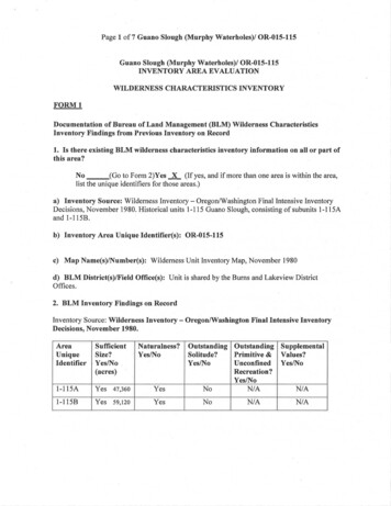
Form 1 – Documentation of BLM Wilderness Inventory: Findings on Record2 of 2WILDERNESS INVENTORY MAINTENANCEIN BLM OREGON/WASHINGTON(Source: Oregon State Office Internal Guidance as of July 2007)Year: 2009Inventory Unit Number/Name: 2-16A, Cottonwood Cr.FORM 1: DOCUMENTATION OF BLM WILDERNESS INVENTORYFINDINGS ON RECORD:1. Is there existing BLM wilderness inventory information on all or part ofthis area?NoYes X (if more than one unit is within the area, list thenames/numbers of those units.):a) Inventory Source: Wilderness Review Intensive Inventory (March, 1980),Pages 32-33.b) Inventory Unit Name(s)/Number(s): Cottonwood Cr., 2-16Ac) Map Name(s)/Number(s): March, 1980; Final Decision on 30 SelectedInventory Units.d) BLM District(s)/Field Office(s): Burns District – Three Rivers ResourceArea and Vale District-Malheur Resource Area.2. BLM Inventory Findings on Record:Inventory Source: Wilderness Review-Intensive Inventory, March, 1980, Pages dCr.Wilderness Inventory Unit6,410NaturalCondition?Y/NNOutstanding Outstanding SupplementalSolitude?Primitive & Values?Y/NUnconfined Y/NRecreation?Y/NNNNCottonwood Creek OR-02-16A3 of 11
Form 2 – Documentation of Current Wilderness Inventory Conditions1 of 5H-6300-1-WILDERNESS INVENTORY MAINTENANCEIN BLM OREGON/WASHINGTONAPPENDIX B – INVENTORY AREA EVALUATIONEvaluation of Current Conditions:1) Document and review the existing BLM wilderness inventory findings on file, ifavailable, regarding the presence or absence of individual wilderness characteristics,using Form 1, below.2) Consider relevant information regarding current conditions available in the officeto identify and describe any changes to the existing information (use interdisciplinary(ID) team knowledge, aerial photographs, field observations, maps, etc.), anddocument your findings on Form 2, below.When Citizen Information has been submitted regarding wilderness characteristics,document the submitted materials including: date of Submission; Name of District(s)and Field Office(s) Affected; Type of material Submitted (e.g. narrative, map, andphotos). Evaluate any submitted citizen information regarding the validity ofproposed boundaries of the unit(s), the existence of roads and other boundaryfeatures, the size of the unit(s), and the presence or absence of wildernesscharacteristics based on relevant information available in the office (prior BLMinventories, ID team knowledge, aerial photographs, field observations, maps, etc.)Conduct field reviews as necessary to verify information and to ascertain currentconditions. Reach conclusions on current conditions including boundaries, size ofareas and presence or absence of wilderness characteristics. Fully explain the basisfor each conclusion on form 2, including any critical differences between BLM andcitizen information.Document your findings regarding current conditions for each inventoried area.Describe how the present conditions are similar to, or have changed from, theconditions documented in the original wilderness inventory. Document your findingson Form 2 for each inventory area. Cite to or attach data considered, includingphotographs, maps, GIS layers, field trip notes, project files, etc.Wilderness Inventory UnitCottonwood Creek OR-02-16A4 of 11
Form 2 – Documentation of Current Wilderness Inventory Conditions2 of 5FORM 2 - DOCUMENTATION OF CURRENT WILDERNESSINVENTORY CONDITIONSUnit Number/Name: 2-16A, Cottonwood Cr.(1) Is the unit of sufficient size?Current Unit Acres: 7,750YesXNoCitizen Information Received: No citizen information for this unit was received.ID-team Meetings: An ID-team consisting of BLM staff from the Burns District met onJanuary 29, 2009, to evaluate this unit. The ID-team was provided with BLM’s currentand past maps and past photographs and other inventory descriptions. The ID-teamconsisted of wilderness, range and planning staff. Wildlife, archaeology, geology andforestry staff was also consulted. Additionally, with the northeast portion of the unitbeing within Vale BLM District, inter-district coordination was conducted as needed.BLM’s Boundary Road Determination Process: BLM completed a route analysis forthe boundary roads identified for the unit. District staff were contacted prior to the IDteam meeting and provided information about current uses of routes by mining personnel,BLM personnel, grazing permittees, and other publics.Some of the interior routes not identified as boundary roads may have been mechanicallyimproved or maintained at some point and may be maintained in the future as needed.Most are in a useable condition, but supporting information about regular use was notidentified in the ID-team meeting. Therefore, these routes were not recognized asboundary roads.Boundary changes since 1979: The northern boundary has changed as the smallsubunit, 16-D, is part of the unit. The western boundary has also changed as subunits 16B, 16-C and 16-E are also part of the present unit. The route which separated subunit Band C from the larger subunit A is now used as a stock trail. The route which separatedsubunit E from subunit A, and was the eastern boundary of a large seeding, is no longer amaintained road.One interior route change is the addition of a bladed road accessing a private land parcelfrom the unit’s west boundary (CNTY Rd 304; Otis Valley-Squaw Creek Rd.). Thischerry-stem route continues through the private land, northward to a livestock reservoiron BLM land.Current Unit Boundaries: (See BLM Unit Character Map): Routes formingboundaries have been mechanically maintained, improved in the past and will continue tobe maintained as needed to allow vehicle passage for public land users. Boundaries ofthe unit are:Wilderness Inventory UnitCottonwood Creek OR-02-16A5 of 11
Form 2 – Documentation of Current Wilderness Inventory Conditions3 of 5N. boundary: Private landNo PhotosE. boundary: CNTY Rd 301 (Cottonwood Reservoir Road)ONDA Photos: HJ42-44;BLM Photos: NoneS. boundary: Private landNo PhotosW. boundary: CNTY Rd 304 (Otis Valley-Squaw Cr. Road)No PhotosInterior Boundary Road: The cherry-stem route described under Boundary changessince 1979 will continue to be used to access private property and a livestock reservoir onBLM land. This reservoir has been constructed since the original inventory wascompleted.(2) Is the unit in a natural condition?YesXNoN/A1979 Unit Description: The unit is located six miles north of the small rural communityof Drewsey. The 1979 Inventory Report noted the unit consisted of rolling hills with ageneral sloping of the area to the east. Vegetation is ponderosa pine and juniper in thenorth and scattered juniper, big and low sage and grass in the remainder of the unit.Squaw Creek, a main drainage, flows southeast into Cottonwood Creek. CottonwoodReservoir, on the eastern boundary, covers 85 surface acres when full.Two livestock reservoirs were located within one-quarter mile of the boundary, threeways were in the central portion, and a road material site was on a hill near the westboundary road. There were two and one-quarter miles of fences. Cottonwood Reservoirwas the most substantial intrusion with an earthen dam and spillway. It is one mile longand one-quarter mile wide with a large expanse of exposed, bare shoreline when water isdrained during the summer for irrigation of ranch hay fields. The imprints of man weresubstantially noticeable and the unit was found to not have naturalness.Current Condition Description: The current unit contains more land area, as itcombines a number of the 1979 original, smaller subunits, to create a much larger unit.However, it is long and narrow, being about two and one-half miles wide at its widestpoint and seven miles long. The well-graded county road (Cottonwood Reservoir Road)which is the unit’s eastern boundary greatly influences the naturalness of the area as doesthe Otis Valley-Squaw Creek Road, a regularly-used route and the unit’s westernboundary. This road provides access to the Malheur National Forest from the rural,agricultural Drewsey Valley. The material site opened to get rock for surfacing the road,is still obvious, although, it’s not been utilized for quite some time. (Note: material site isnot depicted on this inventory unit’s associated map “Wilderness Inventory MaintenanceOtis Mtn. Fuels EA”.)Wilderness Inventory UnitCottonwood Creek OR-02-16A6 of 11
Form 2 – Documentation of Current Wilderness Inventory Conditions4 of 5The primary human uses are associated with livestock grazing. The unit is within twograzing allotments, the southeast area in Cottonwood Creek Allotment and the northernportion in Otis Mountain Allotment. A pasture fence about five miles long divides theunit from N-S with E-W fences division fences in both the northern and southern sectionsof the unit.There are four livestock reservoirs, a large seeding established in 1960 in the southwestcorner, a string of juniper cuts/aspen protection sites in the northwest corner and a 160acre parcel of private land in the unit’s south-central area.Cottonwood Reservoir is located on the east unit boundary. The dam and spillway areobvious to the casual observer when viewed from the CNTY 301 Road (CottonwoodReservoir Road) near the reservoir. This water development is not obvious from greaterdistances, as it is confined within a drainage with rims and hills rising above thereservoir. It can be easily seen from nearby high elevations. The ID-team found that theimprint of humans is not substantially noticeable and that the unit is natural. The unitcurrently has the following developments: (See Unit Character Map):Reservoirs: 4Fences: 21 milesCattleguards: 1Non-Boundary routes: 12 milesThinnings (Ponderosa Pine; pre-commercial): 349 acres(3) Does the unit have outstanding opportunities for solitude?YesNoXN/A1979 Unit Description: The subunit is two miles wide or less. The ponderosa pine andjuniper provided good screening in the north, but the low vegetation in the remainingthree-quarters of the area did not. The report indicated the unit was only one-half milewide where the tree screening was located. Overall, the unit does not offer outstandingopportunities for solitude due to narrowness and the limited topographic and vegetativescreening.Current Condition Description: The original description is still accurate. The unitcontinues to be long and narrow (two to two and one-half miles wide) even withadditional acreage. About three-quarters of the east-sloping area would not offeropportunities for solitude with its open, far-viewing landscape. The sights and sounds ofpeople and their activities can be seen and heard from many locations.(4) Does the unit have outstanding opportunities for primitive and unconfinedrecreation?YesWilderness Inventory UnitNoXN/ACottonwood Creek OR-02-16A7 of 11
Form 2 – Documentation of Current Wilderness Inventory Conditions5 of 51979 Unit Description: The subunit offered opportunities for hiking, backpacking,fishing and horseback riding, but none were outstanding.Current Condition Description: The ID-team found that the recreation opportunitiesoriginally identified are likely still present. People fish in Cottonwood Reservoir in thespring and early summer. This impoundment was built for irrigation and most of thewater is drained when alfalfa fields, hay fields and pastures are watered throughout thesummer. The water quality for fisheries is poor due to extreme water fluctuation, lack ofvegetation and a rocky reservoir bottom. The diversity and quality of primitive andunconfined recreation are not unlike those which can be found on public lands in themuch of eastern Oregon in the Northern Great Basin region. They are not unique and donot present characteristics either individually or collectively that would result in theirbeing outstanding.(5) Does the unit have supplemental values?YesXNoN/A1979 Unit Description: None known.Current Condition Description: Greater Sage Grouse have been seen along the westernboundary of this unit and a lek is located in the southwest corner. This area is also deerand elk winter range.Redband Trout can be found in Cottonwood Creek on BLM land just above CottonwoodReservoir and in a long section of creek on private land between the Cottonwood Creekand Rocky Basin Units. Although not a Federal Special Status Species, it is a BLMSpecial Status Species in the Northern Great Basin Region.Wilderness Inventory UnitCottonwood Creek OR-02-16A8 of 11
Form 2 – Summary of Findings and Conclusion1 of 2Summary of Findings and ConclusionUnit Name and Number: Cottonwood Cr., 2-16Summary Results of Analysis:1. Does the area meet any of the size requirements? X Yes2. Does the area appear to be natural? X YesNoNo3. Does the area offer outstanding opportunities for solitude or aprimitive and unconfined type of recreation? Yes X No4. Does the area have supplemental values? X YesNoNANAConclusion (Check One):The area-or a portion of the area-has wilderness character.X The area does not have wilderness character.Prepared by: David E. Vickstrom, Wilderness SpecialistWilderness Inventory UnitCottonwood Creek OR-02-16A9 of 11
Form 2 – Summary of Findings and ConclusionWilderness Inventory UnitCottonwood Creek OR-02-16A2 of 210 of 11
Wilderness Inventory UnitCottonwood Creek OR-02-16A11 of 11
Bureau of Land Management . Vale District Office . 100 Oregon Street . Vale, Oregon 97918 . . Inventory Source: Wilderness Review-Intensive Inventory, March, 1980, Pages 32-33. Unit#/ Name . big and low sage and grass in the remainder of the unit. Squaw Creek, a main drainage, flows southeast into Cottonwood Creek. .