Transcription
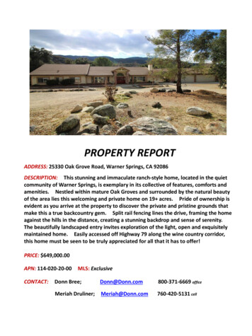
PROPERTY REPORTADDRESS: 25330 Oak Grove Road, Warner Springs, CA 92086DESCRIPTION: This stunning and immaculate ranch-style home, located in the quietcommunity of Warner Springs, is exemplary in its collective of features, comforts andamenities. Nestled within mature Oak Groves and surrounded by the natural beautyof the area lies this welcoming and private home on 19 acres. Pride of ownership isevident as you arrive at the property to discover the private and pristine grounds thatmake this a true backcountry gem. Split rail fencing lines the drive, framing the homeagainst the hills in the distance, creating a stunning backdrop and sense of serenity.The beautifully landscaped entry invites exploration of the light, open and exquisitelymaintained home. Easily accessed off Highway 79 along the wine country corridor,this home must be seen to be truly appreciated for all that it has to offer!PRICE: 649,000.00APN: 114-020-20-00CONTACT:MLS: ExclusiveDonn Bree;Donn@Donn.com800-371-6669 officeMeriah Druliner;Meriah@Donn.com760-420-5131 cell
25330 Oak Grove Rd, Warner Springs, CA 92086Property Features 649,000.00 19 Acres 3,409 esf HomeEXCEPTIONAL COUNTRY LIVING 3 Bed 2.5 Bath 4 Car Garage Solar Electric Backup Generator RV Hookups Seasonal Creek Fenced Rear Yard Covered PatioThis stunning and immaculate ranch-style home,located in the quiet community of Warner Springs,is exemplary in its collective of features, comfortsand amenities. Nestled within mature Oak Grovesand surrounded by the natural beauty of the arealies this welcoming and private home on 19 acres.Pride of ownership is evident as you arrive at theproperty to discover the private and pristinegrounds that make this a true backcountry gem.Split rail fencing lines the drive, framing the homeagainst the hills in the distance, creating a stunningbackdrop and sense of serenity. The beautifullylandscaped entry invites exploration of the light,open and exquisitely maintained home. Easilyaccessed off Highway 79 along the wine countrycorridor, this home must be seen to be trulyappreciated for all that it has to offer! Don’t missthis opportunity to make your country livingdreams come true!RED HAWK REALTYJunction Hwy 78 & Hwy 79Santa Ysabel, CA 92070CalBRE#01997162www.DONN.comWe Know The Backcountry!RED HAWK REALTYJunction Hwy 78 & Hwy 79Santa Ysabel, CA 92070CREB#01109566www.DONN.comWe Know The Backcountry!
HOMEA beautifully landscaped entry is rich withseveral rose varieties, Daffodils, Camelia andother seasonal flowering plants. The drive islined with colorful Oleander, Vinca, Pines andOak varietals, framed by richly colored rockoutcroppings. The home features a wonderfulopen floor plan, vaulted ceilings, decorativewindows and plenty of natural light. The entryleads to a large formal living area with windowseating and a separate family room with anexpansive brick fireplace and wood burningstove insert. The formal dining area and casualbreakfast seating area frame the large kitchenwhich features oak cabinetry, an island, glassdoor display cabinets and bar seating at eachend. A wet bar and powder room make thisspace ideal for entertaining! The large laundryroom is equipped with a deep utility sink, amplebuilt-in cabinet storage, built-in ironing board and is accessible from theinterior as well as exterior of the home. A large 4 car garage is locatedacross the breezeway and provides ample parking as well as storagespace. The large master bedroom features a pellet stove, sliding dooraccess to the patio, a large walk-in closet and newly remodeled bath withwalk-in shower and seated vanity. Two additional bedrooms are joinedby a Jack and Jill bath and offer ample closet space. Additional closetspace in the hallway offers plenty of storage. Newer hardwood flooring,tile, carpet and paint are found throughout the home. Forced central airis in place in addition to the pellet and wood burning stoves. This homeis also complete with a whole house water filtration system and a tankless water heater which supplies endless hot water.FEATURESPowered by a grid tied solar electric system, the home also features anautomatic backup emergency Generac generator. Excess power is fedback to the grid and all 60 solar panels are paid-in-full. A whole-housesprinkler system is in place. A well and 10 thousand gallon holdingtank supply water to the home and surrounding property. RV hookupsare in place at the property entrance with separate septic, well accessand electric meters creating potential for an income producing site orextended stay location for visitors! A rainwater catchment system is inplace as are raised garden beds, equipped with drip irrigation. A large,covered patio is an ideal place to entertain and enjoy the privacy andserenity that the home has to offer. The rear yard is fenced and hostsmultiple storage sheds, a chicken coop and plenty of room to expandand explore your gardening creativity. Beyond the fenced rear yard isa seasonal creek rich with Sycamore trees, Oak varietals and nativevegetation. A large, flat, partially fenced pasture is located beyond thecreek and could potentially host horses, small livestock or your veryown vineyard! A portion of the property is contiguous with theCleveland National Forest, ensuring privacy and preservation.This 19 acre property has been meticulously maintained and well caredfor, with great attention given to detail, safety and comfort. While it is aturn-key home it is still beaming with potential for additional featuresand personalization. Enjoy the privilege of immediate occupancy with alifetime of enjoyment and creativity!“We Know the Backcountry!”
Donn Bree, Ph.D., G.R.I.POB 188Santa Ysabel, CA 92070800-371-6669Donn@Donn.comwww.Donn.comPROPERTY DESCRIPTIONWarner Springs Ranch Home25330 Oak Grove RoadWarner Springs, CA 92086Page: 1 of 3
Donn Bree, Ph.D., G.R.I.POB 188Santa Ysabel, CA TION & OVERVIEWThe home features a wonderful open floor plan, vaulted ceilings, decorative windows and plenty of naturallight. The entry leads to a large formal living area with window seating and a separate family room with anexpansive brick fireplace and wood burning stove insert. The formal dining area and casual breakfastseating area frame the large kitchen which features oak cabinetry, an island, glass door display cabinetsand bar seating at each end. A wet bar and powder room make this space ideal for entertaining! The largelaundry room is equipped with a deep utility sink, ample built-in cabinet storage, built-in ironing board andis accessible from the interior as well as exterior of the home. A large 4 car garage provides ample parkingas well as storage space. The large master bedroom features a pellet stove, sliding door access to the patio,a large walk-in closet and newly remodeled bath with walk-in shower and seated vanity. Two additionalbedrooms are joined by a Jack and Jill bath and offer ample closet space. Additional closet space in thehallway offers plenty of storage. Newer hardwood flooring, tile, carpet and paint are found throughout thehome. Forced central air is in place in addition to the pellet and wood burning stoves. A whole housewater filtration system and tankless water heater are in place.Powered by a grid tied solar electric system, the home also features an automatic backup emergencyGenerac generator. Excess power is fed back to the grid and all 60 solar panels are paid-in-full. A wholehouse sprinkler system is in place. A water well and 10 thousand gallon holding tank supply water to thehome and surrounding property. RV hookups are in place at the property entrance with separate septic,well access and electric meters creating potential for an income producing site. A rainwater catchmentsystem is in place as are raised garden beds, equipped with drip irrigation. The rear yard is fenced andhosts multiple storage sheds, a chicken coop and plenty of room to expand and explore your gardeningcreativity. A portion of the property is contiguous with the Cleveland National Forest, ensuring privacyand preservation of the natural beauty of the area. A70 zoning provides opportunity for a variety of landuse activities.NATURAL SETTINGTopographically, the property is comprised of mostly flat, usable land, lending itself to great utility. Large,mature oaks dominate the indigenous landscape. Sycamore and Pines are found throughout the property asis a mixture of lush, native vegetation. Oleander and Vinca create welcoming color at the front of thehome. Beautiful rock outcroppings are found throughout the property. A seasonal creek runs behind thehome, with enchanting hills in the background, creating a private and peaceful setting. Wildlife is abundantin the area: deer and turkey roam freely, while raptors and other rare species of animals can be found herebecause of the abundance of water and cover.Page: 2 of 3
Donn Bree, Ph.D., G.R.I.POB 188Santa Ysabel, CA 92070800-371-6669Donn@Donn.comwww.Donn.comAREA INFORMATIONThe community of Warner Springs, in the northern backcountry of San Diego County, is rich with history.Located along Highway 79 along the area offers a sense of community as well as convenience andopportunity. There are many fine restaurants and lodging accommodations in the immediate area of thiscentrally, yet privately located property. The town of Temecula and access to major shopping andresources are no more than 25 minutes away.RECREATION AND LIFESTYLEThere are many recreational activities available in the area: the California Riding and Hiking Trail and thePacific Crest Trail for riding, golfing at Warner’s Ranch and Borrego Springs, hunting and fishing, dinning,and a variety of other opportunities for each family member. The famous Hale Observatory on PalomarMountain is less than 30 minutes away.Page: 3 of 3
Disclaimer: This report is completed on a regional level with conservative data. The information provided is to be used as screening criteria only. All data is subject to review and may beverified through project site visits. This report may also include user generated static output from an internet mapping site. The information in this preliminary report may or may not beaccurate, current, or reliable and may need to be changed on the basis of a more specific review.Report Run Date/Time:Project Manager:Land Development Manager:Project Record ID:Project Environmental Review (ER) ID:Assessor's Parcel Number(s):Project Name:2/16/2018 8:50:19 AM11402020001140202000General InformationUSGS Quad Name/County Quad Number:Section/Township/Range:Tax Rate Area:Thomas Guide:Site Address:Aguanga/121/09S/02E980001033/F125330 Oak Grove Truck TrlWarner Springs 92086-9249Parcel Size (acres):Board of Supervisors District:19.735Public Service and Utility DistrictsWater/Irrigation District:NoneSewer District:Fire Agency:NoneCounty Service Area No 135;Csa 135School District:Unified Warner1 of 5
1140202000General Plan InformationGeneral Plan Regional Category:General Plan Land Use Designation:RuralRural Lands (Rl-80) 1 Du/80 AcCommunity Plan:North MountainRural Village Boundary:Village Boundary:Special Study Area :NoneNoneNoneZoning InformationUse Regulation:Animal Regulation:Density:Minimum Lot Size:Maximum Floor Area Ratio:Floor Area Ratio:Building Type:Height:Setback:Lot Coverage:Open Space:Special Area Regulations:A70O8AcCGCAestheticThe site is located within one mile of a State Scenic Highway.The site contains steep slopes 25%.The site is located within Dark Skies "Zone A".NoYesYesAgricultural ResourcesThe site is a Farmland Mapping and Monitoring Program (FMMP) designated farmland.The site contains Prime Soils.There is evidence of active agriculture on the project site.NoYesPlease Refer To Aerial ImagerySunset Zone:The site is located within an Agricultural Preserve.The site is in a Williamson Act Contract.18NoNo2 of 5
1140202000Biological ResourcesEco-Region:Oakgrove-San Jacinto FoothillVegetation Map37300 Red Shank Chaparral;61310 Southern Coast LiveOak Riparian Forest; 71162Dense Coast Live OakWoodlandThe site may contain rare/listed plants and animals found in the Sensitive Species matrix.The site is located within a Quino Checkerspot Butterfly Survey Area.The site contains Wetlands.The site is within one mile of Biological Easements.The site is within one mile of Multiple Species Conservation Program (MSCP) PreApproved Mitigation Area (PAMA).YesYesYesNoNo (Draft: East)The site is within MSCP Boundaries.The site is outside of MSCP and within 500 feet of:Coastal Sage ScrubMaritime Succulent ScrubDiegan Coastal Sage ScrubInland Form ( 1,000 ft. elevation)Coastal Sage - Chaparral ScrubFlat-Topped Buckwheat/Montane Buckwheat ScrubNone of the aboveThe site is located within the North County Habitat Evaluation Map. If yes, list the HabitatValue.No (Draft: East)The site is located within the Ramona Grassland area.The site is located within three miles of a National Wildlife Refuge. If yes, list the name ofthe Refuge.NoNoNoNoNoNoNoNoYesNoCultural and Paleontological Resources (*always confirm with Cultural and Paleontology Specialists)Geological Formation:Cretaceous Plutonic;Quaternary AlluviumPaleo Sensitivity:Paleo Monitoring:Low; ZeroMonitoring ByGrading/Excavation ContractorGeologyAlquist-Priolo Zone:County Special Study Zone:Quaternary/Pre-Quaternary Fault:Potential Liquefaction Area:Soils Hydrologic Group:The site is located in a Landslide Susceptibility Area. If yes, list the Landslide Category.NoNoNoYesA; DYes: High/-/-The site is located within a High Shrink Swell Zone (Expansive Soil).The site is located within an area categorized as high or moderate potential for uniquegeologic features. If yes, name the unique geologic features.NoNo3 of 5
1140202000Mineral ResourcesThe site is located within a Mineral Resource Category.No Mrz (Yes Alluvium/NoMines)Hazard FloodingThe site is located within a FEMA flood area.The site is located within 1/2 mile from a FEMA flood area.The site is located within a County Flood Plain area.The site is located within 1/2 mile from a County Flood Plain area.The site is located within a County Floodway.The site is located within 1/2 mile from a County Floodway.The site is located within a Dam Inundation Zone.NoNoNoNoNoNoNoHazardous MaterialsSchools are located within 1/4 mile of the project.The site is located on or within 250 feet of the boundary of a parcel containing a historicwaste disposal/burn site.The site is located within one mile of a property that may contain military munitions (UXOUnexploded Ordnance).The site is located within 1000 feet of buried waste in a landfill.The site is listed in the Hazardous Material Establishment Listing. If yes, list name,establishment number, and permit number.NoNoNoNoNoThe site is located within 2000 feet of a listing in DTSC's Site Mitigation and Brownfields NoReuse Program Database ("CalSites" EnviroStor Database).The site is listed on the Geotracker listing.NoThe site is listed on the Resource Conservation and Recovery Act Information (RCRAInfo) Nolisting for hazardous waste handlers.The site is listed in the EPA's Superfund CERCLIS database.The site shows evidence that prior agriculture, industrial use, or a gas station or vehiclerepair shop existed onsite.NoPlease Refer To Aerial ImageryThe site contains existing homes or other buildings constructed prior to 1980.Please Refer To Aerial ImageryAirport HazardsThe site is located in a FAA Notification Zone. If yes, list the height restrictions.NoThe site (or portion of the site) is located within an Airport Influence Area. If yes, list thename of the airport.NoThe site is located within an airport safety zone. If yes, list the zone number.NoThe site is located within an Airport Land Use Compatibility Plan Area (Z.O. Section 5250, No"C" Designation).The site is within one mile of a private airport. If yes, list the name of the airport.No4 of 5
1140202000Hydrology and Water QualityHydrologic Unit:Sub-basin:The site is tributary to an already impaired waterbody, as listed on the Clean Water ActSection 303(d) list? If yes, list the impaired waterbody.Santa Margarita902.92/Previtt CanyonYes: Santa Margarita Lagoon;Santa Margarita River (Lower);Santa Margarita River (Upper);Temecula Creek; RedhawkChannelYesNoThe site is tributary to an Environmentally Sensitive Area.The site is located in a Source Water Protection Area.Water Supply/GroundwaterThe site is located outside (east) of the County Water Authority boundary.The site is in Borrego Valley.The project is groundwater dependent.Annual rainfall:YesNoYes21 To 24 InchesNoiseThe site is within noise contours.NoFire ServicesThe site is located in an Urban-Wildland Interface Zone.FRA/LRA/SRA:YesSraAdditional InformationThe site is located within 150 feet of Mexican Border.The site is located within a Resource Conservation Area.The site is located in a Special Area.There are existing or proposed trails on site or adjacent properties.The site is located in an urbanized area as defined by the U.S. Census Bureau.The population has a density of 1,000 per square mile or greater.The site APN is listed in the GP Housing Element inventory.NoNoNoNoNoNoNoCEQA-Public Review Distribution MatrixThe site is located in the Desert.The site is located east of the County Water Authority boundary.All or a portion of the site is east of the Tecate Watershed Divide.The site is located immediately adjacent to a State Highway or Freeway.The site is located south of State Highway 78.The site is located in the Coastal Zone requiring a Coastal Development Permit.The site is located in the Sweetwater Basin.The site is located within 2640 feet (1/2 mile) of the Cleveland National Forest.There are State Parks that are located within 1/2 mile of the site, or may be substantiallyaffected by the project. If yes, list the name of State Park(s).NoYesNoNoNoNoNoYesNo5 of 5
GR OVESTATIO NROA K GOVEOAKC G -BTOPO M AP79 WO O D RID G E LNLeg en d:O A K G RO VE T K T LPROJECT AR EAO AK GR O VE TK T LC opyright: 2013 N a tion al G eo graphic S o ciety, i-c ubed00.10.2NAD 1 98 3 Sta te Plan e C alifo rnia VI FIPS 04 0 6 Fe etPlanning and Development Services0.30.4M ile s This m ap is generated automatically from an internet m apping site and is for reference only.Data layers that appear on this map m ay or may not be accurate, current, or otherwise reliable.THIS MAP IS NO T TO BE USE D F OR NAVIG ATIO N.Note s:
GENERAL PLAN - LAN D USEO A K G RO VE T K T L 00.0 60.1 2NAD 1 98 3 Sta te Plan e C alifo rnia VI FIPS 04 0 6 Fe etPlanning and Development Services0.1 8Leg en d:PROJECT AR EAG EN ER A L P LA N (A U G U ST 2 011 )Village Residential (VR-30)Village Residential (VR-24)Village Residential (VR-20)Village Residential (VR-15)Village Residential (VR-10.9)Village Residential (VR-7.3)Village Residential (VR-4.3)Village Residential (VR-2.9)Village Residential (VR-2)Semi-R ural R esidential (SR -.5)Semi-R ural R esidential (SR -1)Semi-R ural R esidential (SR -2)Semi-R ural R esidential (SR -4)Semi-R ural R esidential (SR -10)Rural Lands (RL-20)Rural Lands (RL-40)Rural Lands (RL-80)Specific Plan Area*Office ProfessionalNeighborhood Com mercialGeneral C ommercialRural C ommercialLimited Im pact IndustrialMedium Im pact IndustrialHigh Im pact IndustrialVillage Core Mixed U sePublic/Sem i-Public FacilitiesPublic/Sem i-Public Lands (SolidW aste Fac ility)0.2 4M ile s This m ap is generated automatically from an internet m apping site and is for reference only.Data layers that appear on this map m ay or may not be accurate, current, or otherwise reliable.THIS MAP IS NO T TO BE USE D F OR NAVIG ATIO N.Public Agency LandsTribal LandsOpen Space (R ecreation)Open Space (C onservation)Note s:*R es id ential d ensities in italic s
VEGETATION1832071161O A K G RO VE T K T L7116218310 Leg en d:PROJECT AR EAVEG E TATIO N C ATEG O RYS outhe rn F ored un es , B e ac h, S altpa n,M ud fla ts37300371306131037300Co as ta l S a ge S cru bCh ap arra lGra ss la ndRipa ria n S c rubRipa ria n W o odlan dRipa ria n Fo res tP iny on J un ipe r W oo dlan dsOther W ood la nd sOa k Fore stVern al P oo l, M e ado w an d S eepM a rshCo nifero us Fo res tDe se rt D u ne s (2 21 00 , 22 30 0, 24 000 )P lay as /B a dland s/M u dh ill Fo rbsDe se rt S c ru bDe se rt C h ap arra lDry W as h W oo dla ndWa ter (inc lu ding 11 200 , 1 32 00)Urb an , D istu rbe d H a bitat, A g ric ulture ,E u ca ly ptu s W ood la nd711621200000.0 60.1 2NAD 1 98 3 Sta te Plan e C alifo rnia VI FIPS 04 0 6 Fe etPlanning and Development Services0.1 80.2 4M ile s This m ap is generated automatically from an internet m apping site and is for reference only.Data layers that appear on this map m ay or may not be accurate, current, or otherwise reliable.THIS MAP IS NO T TO BE USE D F OR NAVIG ATIO N.Note s:
W ETLAND SO A K G RO VE T K T L 00.0 60.1 2NAD 1 98 3 Sta te Plan e C alifo rnia VI FIPS 04 0 6 Fe etPlanning and Development Services0.1 8Leg en d:PROJECT AR EAWETLANDS0.2 4M ile s This m ap is generated automatically from an internet m apping site and is for reference only.Data layers that appear on this map m ay or may not be accurate, current, or otherwise reliable.THIS MAP IS NO T TO BE USE D F OR NAVIG ATIO N.Note s:
STEEP SLOPESO A K G RO VE T K T L 00.0 60.1 2NAD 1 98 3 Sta te Plan e C alifo rnia VI FIPS 04 0 6 Fe etPlanning and Development Services0.1 8Leg en d:PROJECT AR EASTEEP SLOPE ( 25%)0.2 4M ile s This m ap is generated automatically from an internet m apping site and is for reference only.Data layers that appear on this map m ay or may not be accurate, current, or otherwise reliable.THIS MAP IS NO T TO BE USE D F OR NAVIG ATIO N.Note s:
2700AGRICULTURAL USE REGULATIONSA70LIMITED AGRICULTURAL USE REGULATIONS2700INTENT.The provisions of Section 2700 through Section 2709 inclusive, shall be known as the A70 LimitedAgricultural Use Regulations. The A70 Use Regulations are intended to create and preserveareas intended primarily for agricultural crop production. Additionally, a limited number of smallfarm animals may be kept and agricultural products raised on the premises may be processed.Typically, the A70 Use Regulations would be applied to areas throughout the County to protectmoderate to high quality agricultural land.2702PERMITTED USES.The following use types are permitted by the A70 Use Regulations:a.Residential Use Types.Family Residentialb.Civic Use Types.Essential ServicesFire Protection Services (see Section 6905)c.Agricultural Use Types.Horticulture (all types)Tree CropsRow and Field CropsPacking and Processing: Limited(Amended by Ord. No. 5508 (N.S.) adopted 5-16-79)(Amended by Ord. No. 6654 (N.S.) adopted 9-21-83)(Amended by Ord. No. 6782 (N.S.) adopted 5-16-84)(Amended by Ord. No. 7741 (N.S.) effective 3-28-90 (Urg. Ord.))(Amended by Ord. No. 9422 (N.S.) adopted 1-9-02)(Amended by Ord. No. 10067 (N.S.) adopted 8-4-10)2703PERMITTED USES SUBJECT TO LIMITATIONS.The following use types are permitted by the A70 Use Regulations subject to the applicableprovisions of Section 2980. The number in quotes following the use type refers to the subsectionof Section 2980 which applies.a.Residential Use TypesMobilehome Residential "18"9-10
2703b.Commercial Use TypesAnimal Sales and Services: Veterinary (Large Animals) "6"Animal Sales and Services: Veterinary (Small Animals) "6"Recycling Collection Facility, Small "2"Recycling Processing Facility, Wood and Green Materials "3"c.Agricultural Use TypesPacking and Processing: Small Winery “22” (see Section 6910)Packing and Processing: Boutique Winery “22” (see Section 6910)Packing and Processing: Wholesale Limited Winery “22” (see Section 6910)(Amended by Ord. No. 5508 (N.S.) adopted 5-16-79)(Amended by Ord. No. 5652 (N.S.) adopted 11-21-79)(Amended by Ord. No. 5935 (N.S.) adopted 11-19-80)(Amended by Ord. No. 6783 (N.S.) adopted 5-16-84)(Amended by Ord. No. 6924 (N.S.) adopted 2-20-85)(Amended by Ord. No. 8058 (N.S.) adopted 4-15-92)(Amended by Ord. No. 9940 (N.S.) adopted 6-18-08)(Amended by Ord. No. 10035 (N.S.) adopted 1-27-10)(Amended by Ord. No. 10067 (N.S.) adopted 8-4-10)2704USES SUBJECT TO A MINOR USE PERMIT.The following use types are allowed by the A70 Use Regulations upon issuance of a Minor UsePermit.a.Civic Use Types.Law Enforcement ServicesMinor Impact UtilitiesSmall Schoolsb.Agricultural Use Types.Farm Labor Campsc.Commercial Use Types.Cottage Industries "17" (see Section 6920)(Amended by Ord. No. 5508 (N.S.) adopted 5-16-79)(Amended by Ord. No. 5935 (N.S.) adopted 11-19-80)(Amended by Ord. No. 6654 (N.S.) adopted 9-21-83)(Amended by Ord. No. 7741 (N.S.) effective 3-28-90 (Urg. Ord.))(Amended by Ord. No. 7768 (N.S.) adopted 6-13-90)(Amended by Ord. No. 7964 (N.S.) adopted 8-14-91)(Amended by Ord. No. 8175 (N.S.) adopted 11-18-92)(Amended by Ord. No. 8271 (N.S.) adopted 6-30-93)(Amended by Ord. No. 10003 (N.S.) adopted 8-5-09)(Amended by Ord. No. 10035 (N.S.) adopted 1-27-10)9-10
27052705USES SUBJECT TO A MAJOR USE PERMIT.The following use types are permitted by the A70 Use Regulations upon issuance of a Major UsePermit.a.Residential Use Types.Group Residentialb.Civic Use Types.Administrative ServicesAmbulance ServicesChild Care CenterCivic, Fraternal or Religious AssemblyClinic ServicesCommunity RecreationCultural Exhibits and Library ServicesGroup CareMajor Impact Services and UtilitiesParking ServicesPostal Servicesc.Commercial Use Types.Agricultural and Horticultural Sales (all types)Explosive Storage (see Section 6904)Participant Sports and Recreation: OutdoorTransient Habitation: Campground (see Section 6450)Transient Habitation: Resort (see Section 6400)d.Agricultural Use Types.Agricultural Equipment StoragePacking and Processing: WineryPacking and Processing: GeneralPacking and Processing: Supporte.Extractive Use Types.Mining and Processing (see Section 6550)(Amended by Ord. No. 5508 (N.S.) adopted 5-16-79)(Amended by Ord. No. 6134 (N.S.) adopted 7-22-81)(Amended by Ord. No. 6543 (N.S.) adopted 3-2-83)(Amended by Ord. No. 6761 (N.S.) adopted 4-25-84)(Amended by Ord. No. 6782 (N.S.) adopted 5-16-84)(Amended by Ord. No. 6855 (N.S.) adopted 10-10-84)(Amended by Ord. No. 10006 (N.S.) adopted 9-16-09)10-09
Animal SchedulePart of Section 3100ANIMAL USE TYPE(See Note 4)Restrictions andDensity RangeDESIGNATORA B C D EFG H IJK LM N O PQ R STU VW XANIMAL SALES AND SERVICES:HORSE STABLE(see Section 3130)XPermittedBoarding of and ridinglessons for up to 3horses not owned bythe property owner10 Horses per acre ofusable area up to 50horses and 5 acres Zoning Verification10 Horses per acre ofusable area up to 100horses and 10 acres Administrative PermitMore than 100 horsesand more than 10 acresof usable area by MUPXXXX XXXX XXXXX XXXX XXXXX XXXX XXXXX XXXX XXXXXPermittedKENNELS (see Note 1)XPermitted provided fullyenclosedXX XX XZAP requiredX XXXXXMUP requiredOne acre by MUPX XXXXXXXXXXXANIMAL RAISING (see Note 6)(a) Animal Raising Projects(see Section 3115)Permitted1 acre by MUP(b) Small Animal Raising(includes Poultry)(See Note 8)X X½ acre by ADX XXXXX XXXXXXXXX½ acre permittedXXX X25 maximumX XX100 max by ZAP(c) Large Animal Raising(Other than horsekeeping)1 acre permittedXX X4 animals plus 4 foreach ½ acre over ½acreXX XXXXX XXXXXXX XXX XX X XXXXXXXXX1 acre or less: 2animalsX X XX1 to 8 acres: 1 per ½acreX X XXX2 animalsXXXX X5510 OVERLAND AVE, SUITE 110, SAN DIEGO, CA 92123 (858) 565-5981 (888) 267-8770www.sandiegocounty.gov/pdsPDS-444 (Rev. 4/2017)XX8 acres permitted2 animals plus 1 per ½acre over 1 acreXXLess than ½ acre: 100MaximumChinchillas (See Note 5)XX100 maximum½ acre 25 max byZAPXXPermitted½ acre : 10 maxXPAGE 5 of 12X
ANIMAL USE TYPE(See Note 4)Restrictions andDensity RangeDESIGNATOR½ acre plus 2 animalsper ½ acre by ZAPX X(See Note 2)Grazing Only(d) Horse keeping (other thanAnimal Sales and Services:Horse Stable)(see Section 3130)Permitted2 horses 1 horse per½ acre over ½ acre Administrative PermitPermitted(e) Specialty Animal Raising:Bees (See Title 6, Division2, Chapter 9, County Code)(See Note 7)(f) Specialty Animal Raising:Wild or Undomesticated(See Note 3)ZAP Required(g) Specialty Animal Raising:Other (Excluding Birds orAquaponics)25 maximum25 maximum by ZAPA B C D EFK LXXXXXXXXXX XXXXXXXXX XXXXXXX XXX XXX XXX XXXXXX XXXXXX XXXXXX XXXXXX XXX XX100 maximumX XXXXXXXW XXXX XX XXXX XX XXX XXXXXXXXXXXXXXXXX XXXXX XXXXX XXXXXXXXXXX XXX100 Max 1/acre plusPermittedANIMAL ENCLOSURE SETBACKS(See Section 3112)Least RestrictiveX XXX100 MaximumModerateU VX25 maximumMost RestrictiveQ R S TXPermitted(i) Racing PigeonsM N O PX XPermittedAdditional by ZAPJX25 plus by ZAP(h) Specialty Animal Raising:BirdsG H IXXXXXXXXXXXXXXXXXXX XX XX XXXXXXXMUP Major Use Permit plusZAP Minor Use PermitNotes:1. Dogs and cats not constituting a kennel and up to two pot-belly pigs are accessory uses subject to the Accessory UseRegulations commencing at Section 6150 and are not subject to the animal enclosure setbacks.2. On land subject to the “S” and “T” Animal Designators, grazing of horses, bovine animals and sheep permitted providedno buildings, structure, pen or corral shall be designated or used for housing or concentrated feeding of animals, andthe number of such animals shall not exceed 1 animal per ½ acre of land.3. One wild or undomesticated animal, kept or maintained in conformance with State and local requirements, is anaccessory use subject to the Accessory Use Regulations commencing at Section 6150, and is not subject to the AnimalSchedule. (Amended by Ordinance Number 7432 (N.S.) adopted January 6, 1988.)4. The Animal Schedule does not apply to small animals, specialty animals, dogs or cats which are kept for sale in zoneswhere the Retail Sales, General Use type is permitted provided that all activities are conducted entirely within anenclosed building, the building is completely soundproof, there are no outside runs or cages, no boarding of
Page: 2 of 3 . Donn Bree, Ph.D., G.R.I. POB 188 Santa Ysabel, CA 92070 800-371-6669 . Donn@Donn.com www.Donn.com. INTRODUCTION & OVERVIEW . The home features a wonderful open floor plan, vaulted ceilings, decorative windows and plenty of natural