Transcription
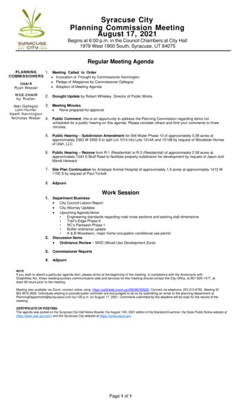
Syracuse CityPlanning Commission MeetingAugust 17, 2021Begins at 6:00 p.m. in the Council Chambers at City Hall1979 West 1900 South, Syracuse, UT 84075Regular Meeting AgendaPLANNING1. Meeting Called to OrderCOMMISSIONERS Invocation or Thought by Commissioner Kennington Pledge of Allegiance by Commissioner GallegosCHAI R Adoption of Meeting AgendaRyan WesselVI C E- C H A I RIvy Ruelan2. Drought Update by Robert Whiteley, Director of Public Works3. Meeting MinutesAlan GallegosLonn Hunter None prepared for approvalKeeth KenningtonNicholas Weber 4. Public Comment, this is an opportunity to address the Planning Commission regarding items notscheduled for a public hearing on this agenda. Please consider others and limit your comments to threeminutes.5. Public Hearing – Subdivision Amendment for Still Water Phase 10 of approximately 0.39 acres atapproximately 2363 W 3350 S to split Lot 1014 into Lots 1014A and 1014B by request of Woodside Homesof Utah, LLC6. Public Hearing – Rezone from R-1 (Residential) to R-3 (Residential) of approximately 2.38 acres atapproximately 1343 S Bluff Road to facilitate property subdivision for development by request of Jason andMandi Harward7. Site Plan Continuation for Antelope Animal Hospital of approximately 1.5 acres at approximately 1412 W1700 S by request of Paul Toniolli8. AdjournWork Session1. Department Business City Council Liaison Report City Attorney Updates Upcoming Agenda Items2. Engineering standards regarding road cross sections and parking stall dimensions Trail’s Edge Phase 6 RC’s Parkwest Phase 1 Buffer ordinance update A & B Woodworx, major home occupation conditional use permitDiscussion Items Ordinance Review – MXD (Mixed Use Development Zone)3. Commissioner Reports4. AdjournNOTEIf you wish to attend a particular agenda item, please arrive at the beginning of the meeting. In compliance with the Americans withDisabilities Act, those needing auxiliary communicative aids and services for this meeting should contact the City Office, at 801-825-1477, atleast 48 hours prior to the meeting.Meeting also available via Zoom; connect online using: https://us02web.zoom.us/j/86396760626. Connect via telephone: 253-215-8782, Meeting ID:863 9676 0626. Individuals wishing to provide public comment are encouraged to do so by submitting an email to the planning department atPlanningDepartment@syracuseut.com by 1:00 p.m. on August 17, 2021. Comments submitted by the deadline will be read for the record of themeeting.CERTIFICATE OF POSTINGThis agenda was posted on the Syracuse City Hall Notice Boards, the August 14th, 2021 edition of the Standard-Examiner, the State Public Notice website athttps://www.utah.gov/pmn/ and the Syracuse City website at https://syracuseut.gov.Page 1 of 1
PLANNING COMMISSIONAGENDAAugust 17, 2021Agenda Item # 3Meeting Minutes None
PLANNING COMMISSIONAGENDAAugust 17, 2021Agenda Item # 4Public Comment:This is an opportunity to address the PlanningCommission regarding your concerns or ideas,regarding items that have not been scheduled for apublic hearing on this agenda. Please limit yourcomments to three minutes.
PLANNING COMMISSIONREGULAR MEETINGAugust 17, 2021ADMINISTRATIVE ITEMAgenda Item #5Still Water Phase 10 Subdivision AmendmentFactual SummationPlease review the following information. Any questions regarding this agenda item may be directed toRoyce Davies, City Planner, or Noah Steele, Community and Economic Development Director.Location:Current General Plan:Current Zoning:Acreage:2363 W 3350 SouthMedium Density ResidentialRPC (Residential Planned Community)0.39SummaryThe applicant is requesting approval of a subdivision amendment to split a large lot at the end of a cul-de-sac toaccommodate an easement needed by Rocky Mountain Power. The split will create two 0.19 acre lots from one0.39 acre lot. The applicant has indicated that they have house plans which fit on the proposed lots while stillallowing for the front setback variation of three feet required in the RPC Zone.All staff comments have been addressed and the proposed plat meets all the requirements of the City Code.RecommendationBecause this item meets all requirements of the City Code, staff recommends it be approved.
Suggested Motion LanguageApprovalI move the Planning Commission approve the request of Woodside Homes, LLC for a subdivision platamendment called Still Water Phase 10 First Amended at 2363 West 3350 South in the Planned ResidentialCommunity Zone.TableI move the Planning Commission continue the request of Woodside Homes, LLC for a subdivision platamendment called Still Water Phase 10 First Amended at 2363 West 3350 South in the Planned ResidentialCommunity Zone until (provide date).DenialI move the Planning Commission deny the request of Woodside Homes, LLC for a subdivision plat amendmentcalled Still Water Phase 10 First Amended at 2363 West 3350 South in the Planned Residential CommunityZone based on the following findings:1. (List findings).Attachments Property MapApplicationSubdivision PlatStaff Reviews
DocuSign Envelope ID: 9745825C-9FAA-456C-98FB-8807E6F7B34ESubdivision Amendment ApplicationSyracuse City Community Development1979 West 1900 South, Syracuse, UT 84075Phone: (801) 825-1477 ext 4Fax:(801) 614-9626Website: www.syracuseut.comEmail: planning@syracuseut.comSubdivision InformationCurrent Subdivision Name: Still Water Phase 10Lot Numbers to be Amended and/or Vacated:Approximate Address:2363 W 3350 SNew Lot Numbers, if Applicable:1014New or Amended Subdivision Name:Still Water Phase 10 lot 1014 AmendmentTotal Acreage of Current Subdivision:6.8Total Acreage of Amended SubdivisionUpdated 7/10/171014A and 1014B6.8Brief Description of Purpose for the Amendment:Split an oversized lot into two, in order to match the original preliminary platProperty Owner Contact Information: (if more than one property owner, attach additional sheets as necessary)Property owner(s):Woodside Homes of Utah, LLC Attn: Ryan BeckCity:460 West 50 North, Ste 300SLCAddress:Office Phone :Cell 101ryan.beck@woodsidehomes.comApplicant Contact Information: (if different from owner)Applicant name:Address:City:Office Phone:Cell Phone:State:ZIP:Email:NOTE: Applicant shall furnish the information on this form for purposes of identification and expediting the request in full knowledge that itmay become public record pursuant to provisions of the Utah State Government Records Access and Management Act (GRAMA). Use ofthis information will be only for necessary completion and execution of the requested transaction. If applicant so chooses not to supply anyrequested information, applicant accepts the additional time in processing or inability to process the application at all. If applicant is an “atrisk government employee” as defined in Utah Code Ann. § 63-2-302.5, please inform a member of the Department staff upon submissionof the application. Syracuse City does not currently share any private, controlled, or protected information with any other person orgovernment entity.I hereby certify that the requested Plat Amendment would comply with all required conditions and standards of the SyracuseCity Land Use Ordinance. I understand that submitting this application does not guarantee approval and is subject to thediscretion of the City Land Use Authority and compliance with all requirements of Syracuse Title X. I hereby acceptresponsibility for meeting all requirements outlined herein, including payment of all fees and attending City Land UseAuthority meetings as notified by the Community Development Department, and understand that failure to do so may resultin postponement of action by said Authority. I also understand that approval of the requested Plat Amendment by CityCouncil is valid for a period of twelve months for recording purposes.Applicant SignatureDateProperty Owner SignatureDate7/7/2021FOR OFFICE USE ONLYDate Received and Paid:Payment Type:CashReceivedby:Credit CardLand Use Authority Date:City Council Decision and Date:Receipt #Check#Application and Noticing Fees: 550 Application FeeLots 50 per Lot 20 per Public Notice Sign Signs 100NoticingTotal 550
DocuSign Envelope ID: 9745825C-9FAA-456C-98FB-8807E6F7B34EGuidelines and ChecklistDISCLAIMER: The City is providing the following information as a service to those wishing to apply for Plat Amendment approval of propertywithin Syracuse City limits. No one shall consider this form as comprehensive in representing the obligations of the applic ant. In the event of aconflict or discrepancy between this document and City Ordinances or State or Building Codes, the more strict rules shall apply.For purposes of noticing the public of a land-use decision related to a Subdivision Amendment, applicant shall provide the CommunityDevelopment Department, as required by City Ordinance, with the following:DescriptionFeeApplication 550 50 per lotPublic Notice SignsNoticing 20 per sign 100CommentsFee includes initial City Planning and Engineering staff review and ONE setof initial plan corrections as identified by City Planning and Engineeringstaff.Sign required per road frontage abutting subject propertyFee includes cost of stamps, property list from County, staff time, etc.The Community Development Department encourages applicants to contact City staff for assistance in addressing and understandingall requirements for any Subdivision Amendment. This form includes all necessary information for filing a complete application thatwill allow the City to process and review it in the timeliest manner possible. City staff will not process incomplete applications, soplease include the following: Read and check each box to acknowledge understanding of all requirements Application and noticing fee payment per the current Syracuse City Fee Schedule CD of AutoCAD files, in .dwg file format, or email of drawings, in .pdf format, to planning@syracuseut.com Three 22”x34” plats and plan & profile sheets plus two 11”x17” copies that include: Amended Subdivision name with the words “Syracuse City” shown at top center of first page Name, address, and phone number of Subdivider Inset vicinity map Outside or trim-line dimension of 19”x30” with border line of 1½” on left margin and a ¼” minimum border on remaining sides Plat drawn with top of sheet as either north or east with all lines, dimensions, and markings in waterproof black ink (no adhesives) Plat at standard engineering scale and with date, north point, and a written or graphic scale Legal description defining Subdivision boundaries that agrees with drawing shown accurately with bearings and dimensions Survey, mathematical information, and plan data to locate and retrace all interior and exterior boundary lines Location, names, and existing widths of adjacent streets Identification of all adjoining subdivisions and land by lot, subdivision name, and land owner(s) Names, widths, lengths, bearings, and curve data on centerlines of proposed streets, alleys, easements, etc. Streets and lots numbered and consecutively addressed according to addressing provided by City staff All lots, blocks, and parcels delineated and designed with a number, dimension, area, boundaries, and courses Monuments and stakes at all key locations to establish lot corners, intersections, P.T., P.C., etc. Rights-of-way lines shown for all streets, utilities, etc. Sidelines of all easements, identified and checked for accuracy Title of consistent subsequent sheets and arranged so that lots are not split between sheets Wet stamp certification of survey by licensed, professional land surveyor Owner’s dedication, signed and acknowledged Notary Public acknowledgement Planning Commission signature block City Engineer’s acceptance and approval signature block City Recorder’s certificate of attest Signed acceptance- and approval-signature blocks for Rocky Mountain Power, Qwest, and Questar Gas utility companies If applicable, a report of changes in design data and final drainage with assumptions and computations for storm-water(as outlined in City Storm Water and Subdivision ordinances) and sanitary-sewer improvements Current land-title report Complete construction improvement cost estimates for review by City Engineer to calculate construction warranty and financingPrior to recording, Planning Commission must hold a public hearing and applicant shall: Execute an amended Escrow Agreement, provided by City staff, for improvement costs and bonding if applicableSubmit changed as-built construction information from selected contractor if applicablePay final off-site inspection fees as outlined in City’s fee schedule for any new inspectionsPay County recording fees of 37 per page plus 1 per lot or common space as well as 1 per land-owner signatures over two
LEGENDSURVEYOR'S CERTIFICATESTILL WATER SUBDIVISIONBOUNDARYSECTION LINEEASEMENTRIGHT-OF-WAY LINEBUILDING SETBACKEXISTING PROPERTY LINEI, Evan J. Wood, do hereby certify that I am a Professional Land Surveyor, and that I holdCertificate No. 183395 in accordance with Title 58, Chapter 22 of Utah State Code. I furthercertify by authority of the owners(s) that I have completed a Survey of the property described onthis Plat in accordance with Section 17-23-17 of said Code, have verified all measurements, andhave subdivided said tract of land into lots, a parcel, streets, and easements, to be hereafterknown as STILL WATER PH 10 1ST AMENDMENT, and the same has, or will be correctlysurveyed and monumented on the ground as shown on this Plat, and that this Plat is true andcorrect.PHASE 10 1ST AMENDMENTAMENDING ALL OF LOT 1014 OF STILL WATER SUBDIVISION PHASE 10BOUNDARY MARKERA PORTION OF THE SE 1/4 OF SECTION 21, T4N, R2W, SLB&MSYRACUSE, DAVIS COUNTY, UTAHSECTION MONUMENT (FOUND)weievEXIST. STREET MONUMENTEAST 1/4 CORNER OFSECTION 21, T4N, R2W, SLB&M3" DAVIS COUNTY MONUMENTGRAPHIC SCALE2122162.58'*SETBACKS TO BE VARIED 3' LOT TO LOT*LOT 1001 - 1017, 10251014B0.19 acres8486 sqftTHOMAS COURT (3350 SOUTH)R 55.00'(PUBLIC - 60' WIDE)Δ 92 18'31"L 88.61'CH S0 01'52"W 79.33'S89 48'41"E71.70'(DCS: N0 11'36"E 2,625.72)(NAD 83: N0 32'25"E 2625.09)5,600 - 7,000 S.F. BUILDING SETBACKSLENGTHCHORD DIRECTIONCHORD LENGTHC155.0046 18'43"44.46S22 58'02"E43.26C255.0045 59'48"44.15S23 11'13"W42.98NOTE:ROTATE BEARINGS 0 20'49" CLOCKWISETO CONVERT TO NAD 83OWNER'S DEDICATIONC1BASIS OF BEARING: N0 11'36"E(SECTION LINE) MEASURED: 2,625.67PUBLIC STREETDELTA1015C2THE A. KELLY GREENFAMILY TRUST4873/1135RADIUSDOMINION ENERGY UTAHN0 11'19"E 326.00'15' MIN. STREETFRONT SETBACK*PUBLIC STREETLOT2400 WEST (PUBLIC - FUTURE 66' WIDE ROW)10' P.U.&D.E.10' P.U.&D.E.5' P.U.&D.E.5' P.U.&D.E.8' MIN.SIDE YARDSETBACK15' MIN. STREETSIDE SETBACKCURVE'LOT10' P.U.&D.E.Curve Table1016.548' MIN.SIDE YARD115"E'25 54'32 151.5 S315' MIN. REARYARD SETBACKN0 11'36"EWEST1,526.58 (TIE)NOTES:1)#5 REBAR & CAP (FOCUS ENG) TO BE SET AT ALL REAR LOTCORNERS. LEAD PLUGS TO BE SET IN THE TOPBACKOFCURB AT THE EXTENSION OF THE SIDE LOT LINES.2)ALL PRIVATE REAR LOT DRAINS ARE HEREBY OWNED ANDMAINTAINED BY THE H.O.A. CITY RESPONSIBILITY WILL END ATTHE CATCH BASIN WHERE THE PRIVATE REAR LOT STORMDRAIN CONNECTS.3)STILL WATER HOMEOWNERS ASSOCIATION, INC: 460 W. 50N. SUITE 200 SALT LAKE CITY, UT 84101.QUESTAR GAS COMPANY dba DOMINION ENERGY UTAH, HEREBYAPPROVES THIS PLAT SOLELY FOR THE PURPOSE OF CONFIRMINGTHAT THE PLAT CONTAINS PUBLIC UTILITY EASEMENTS. DOMINIONENERGY UTAH MAY REQUIRE ADDITIONAL EASEMENTS IN ORDER TOSERVE THIS DEVELOPMENT. THIS APPROVAL DOES NOT CONSTITUTEABROGATION OR WAIVER OF ANY OTHER EXISTING RIGHTS,OBLIGATIONS OR LIABILITIES INCLUDING PRESCRIPTIVE RIGHTS ANDOTHER RIGHTS, OBLIGATIONS OR LIABILITIES PROVIDED BY LAW OREQUITY. THIS APPROVAL DOES NOT CONSTITUTE ACCEPTANCE,APPROVAL OR ACKNOWLEDGEMENT OF ANY TERMS CONTAINED INTHE PLAT, INCLUDING THOSE SET FORTH IN THE OWNERS DEDICATIONOR THE NOTES, AND DOES NOT CONSTITUTE A GUARANTEE OFPARTICULAR TERMS OR CONDITIONS OF NATURAL GAS SERVICE. FORFURTHER INFORMATION PLEASE CONTACT DOMINION ENERGYUTAH'S RIGHT-OF-WAY DEPARTMENT AT 800-366-8532.QUESTAR GAS COMPANYdba DOMINION ENERGY UTAHAPPROVED THIS DAY OF A.D. 20WE, THE UNDERSIGNED OWNERS OF THE HEREON DESCRIBED TRACT OF LAND,HEREBY SET APART AND SUBDIVIDE THE SAME INTO LOTS, STREETS, PARCELS ANDEASEMENTS AS SHOWN ON THIS PLAT, AND NAME SAID TRACTSTILL WATER SUBDIVISIONPHASE 10AND DO HEREBY DEDICATE, GRANT AND CONVEY TO SYRACUSE CITY, DAVISCOUNTY, UTAH, ALL THOSE PARTS AND PORTIONS OF SAID TRACTS OF LANDDESIGNATED AS STREETS, THE SAME TO BE USED AS PUBLIC THOROUGHFARESFOREVER, ALSO THOSE CERTAIN STRIPS AS EASEMENTS FOR PUBLIC UTILITY ANDDRAINAGE PURPOSES AS SHOWN HEREON, THE SAME TO BE USED FOR THEINSTALLATION, MAINTENANCE AND OPERATION OF PUBLIC UTILITY SERVICE LINESAND DRAINAGE AS MAY BE AUTHORIZED BY SYRACUSE CITY. PURSUANT TO CITYCODE 10-9a-604(d), DEDICATE TO STILWATER HOMEOWNERS ASSOCIATION, INC. WITHA REGISTRATION ADDRESS OF 460 W. 50 N. SUITE 200 SALT LAKE CITY, UT 84101PARCEL A AND B TO BE USED AS COMMON AREA AND PUBLIC UTILITY EASEMENTS;THE SAME TO BE USED FOR THE INSTALLATION, MAINTENANCE AND OPERATION OFPUBLIC UTILITY SERVICE LINES AND DRAINAGE AS MAY BE AUTHORIZED BYSYRACUSE CITY. TO WARRANT AND DEFEND AND SAVE THE CITY HARMLESSAGAINST ANY EASEMENTS OR OTHER ENCUMBRANCES ON THE DEDICATED STREETSWHICH WILL INTERFERE WITH THE CITY'S USE, MAINTENANCE AND OPERATION OFTHE STREETS.SIGNED THIS DAY OF , 20BYSTILLWATER PHASE 101014ATITLE0.20 acres8546 sqftWOODSIDE HOMES OF UTAH, LLCROCKY MOUNTAIN POWER163.42'APPROVED THIS DAY OF20 , ROCKY MOUNTAIN POWER1012BY:(PRINTED NAME)ITS:BYLIMITED LIABILITY ACKNOWLEDGMENT15"W 2.18'152.18'10135 50'49TITLES31007FOCUSãENGINEERING AND SURVEYING, LLC6949 HIGH TECH DRIVEMIDVALE, UTAH 84047 PH: (801) 352-0075www.focusutah.comCITY ENGINEERSTATE OF UTAHS.S.COUNTY OFON THE DAY OF A.D. 20 PERSONALLY APPEAREDBEFORE ME , THE UNDERSIGNED NOTARY PUBLIC, IN AND FOR THE COUNTY OF, IN SAID STATE OF UTAH, ,WHO AFTER BEING DULY SWORN, ACKNOWLEDGED TO ME THAT HE/SHE IS THEOF L.L.C., A UTAH L.L.C. ANDTHAT HE/SHE SIGNED THE OWNER'S DEDICATION FREELY AND VOLUNTARILY FORAND IN BEHALF OF SAID LIMITED LIABILITY COMPANY FOR THE PURPOSESTHEREIN MENTIONED.1008N89 58'45"W (SECTION LINE) 2,653.63(DCS: N89 59'02"W 2653.30)(NAD 83: N89 38'10"E 2653.07)1009SOUTHEAST CORNER OFSECTION 21, T4N, R2W, SLB&M3" DAVIS COUNTY MONUMENTOWNER/DEVELOPERWOODSIDE HOMES OF UTAH LLC460 WEST 50 NORTH #200,SALT LAKE CITY, UTAH 84101(801) 869-4000CONTACT: DEREK TERRYFAll of Lot 1014, STILL WATER SUBDIVISION, according to the official plat there ofrecorded June 24, 2021 as Entry No. 3394057 in Book 7788 at Page 894 in the office of theDavis County Recorder, located in the Southeast Quarter of Section 21, Township 4 North,Range 2 West, Salt Lake Base and Meridian, more particularly described as follows:Beginning at the northerly corner of Lot 1014 STILL WATER SUBDIVISION,according to the official plat there of recorded June 24, 2021 as Entry No. 3394057 in Book7788 at Page 894 in the office of the Davis County Recorder, located N00 11'36"E 1,990.97feet along the Section line and West 1,947.11 feet from the Southeast Corner of Section 21,T4N, R2W, SLB&M; running thence along said Lot 1014 the following (1) S35 32'25"E151.54 feet; thence (2) southerly along the arc of a non-tangent curve to the left having a radiusof 55.00 feet (radius bears: S43 48'53"E) a distance of 88.61 feet through a central angle of92 18'31" Chord: S00 01'52"W 79.33 feet; thence (3) S35 50'49"W 152.18 feet; thence (4)N00 11'19"E 326.00 feet to the point of beginning.Contains: 17,031 square feet or 0.39 acres /-( IN FEET )1 inch 30 ft.FUTURE DEVELOPMENT1,990.97 (TIE)VICINITY MAPDATEBOUNDARY DESCRIPTIONFUTURE DEVELOPMENTPOINT OFBEGINNINGRorEVAN J. WOODPROFESSIONAL LAND SURVEYORCERTIFICATE NO. 183395PLANNING COMMISSIONSOUTH 1/4 CORNER OFSECTION 22, T4N, R2W, SLB&M22 3" DAVIS COUNTY MONUMENT21 2227 28CITY ATTORNEYAPPROVED AS TO FORM THIS DAY OF, A.D., 20 .APPROVED THIS DAY OF20 , BY THE SYRACUSE CITY PLANNINGCOMMISSION.APPROVED AS TO FORM THIS DAY OF, A.D., 20 .SYRACUSE CITY ENGINEERCHAIRMAN, PLANNING COMMISSIONSYRACUSE CITY ATTORNEYA NOTARY PUBLIC COMMISSIONED INUTAH RESIDING IN COUNTYMY COMMISSION No.PRINTED FULL NAME OF NOTARYDATE: 06/29/2021CITY COUNCIL27MY COMMISSION EXPIRES:RECORDED #PRESENTED TO THE SYRACUSE CITY COUNCIL THISDAY OF , 20 . AT WHICHTIME THIS SUBDIVISION WAS APPROVED ANDACCEPTED.STATE OF UTAH, COUNTY OF DAVISRECORDED AND FILED AT THE REQUEST OFMAYORDATE TIME BOOK PAGEATTESTCITY RECORDER FEECOUNTY RECORDER
BOUNDARYROWCENTERLINELOT LINEEASEMENT15" STORM DRAIN8" SANITARY SEWER8" CULINARY WATER8" SECONDARY WATERCONTOUR MAJORCONTOUR MINOREXIST. STORM DRAINEXIST. SANITARY SEWEREXIST. CULINARY WATEREXIST. FENCEEXIST. CONTOUR MAJOREXIST. CONTOUR MINOR8 SD////////////////10 SW8 SSWM////8W1018////10 W////15 SDSIGNSTREET LIGHTSD MH, INLET, AND COMBO////15 SDSEWER MANHOLEVALVE, TEE & BEND////WATER BLOW-OFF////STREET MONUMENT (TO BE SET)////10178 SW10 SW1016EXIST. STREET MONUMENT8 SSEXIST. SD INLET & MH////EXIST. SEWER MHEXIST. FIRE HYDRANTSPOT ELEVATIONWM15 SD////101515 SD////////10198 SW8 SS8 SW8 SS////////10 W////8W////10 SW////CULINARY WATERLAT AND METERTO REMAIN////1014BWM15 SD////////WMWM//8W////////WM//////10 W//////////////INSTALL SECONDARY WATER LAT102015 SD////CUT AND REPLACECURB AND GUTTER//////10 SW////SEWER LATERALLAT TO REMAIN////8 SW8 SW8 SW////8 SW////////////15 SD8 SS8 SS8 SS8 SSSS8 SS////////////////SS////////////CUT AND REPLACECURB AND GUTTER8 SW////8W8W8W8W////8W////10 SW////CUT AND REPLACE SIDEWALKWM////WM////////10 W8 SS////////INSTALL 4" SEWER LATERAL15 SD////////////////102115 SD////8WCUT AND REPLACE SIDEWALK////1014AWMWM8 SW////10 SW////CUT AND REPLACEASPHALT 865 S.F.////8 SS15 SD////INSTALL 34" CULINARYWATER METER AND LATERAL////10 WSECONDARY WATERLAT TO REMAIN////////////10 SW////10138W1012101110228 SW////15 SDCUT AND REPLACECURB AND GUTTER////10 W////8 SS15 SD////WM////8W15 SD////////////10 W10098 SS////1008201010////8W15 SD15 SD////10240102040( IN FEET )1 inch 20 ft.---------------6------45------3------28 SW10 SW////1007GRAPHIC SCALE----8 SD////SD----////8 SD18W15 SD////8 SDDATE////REVISION BLOCK////10 W////8 SS15 SD////WM#8 SW////10 SW////DESCRIPTION////1023WM80SITE ANDUTILITY PLAN////8 SW////10 SW////Scale:WMDate:1" 20'06/29/20Drawn:Job #:Sheet:C3.0CSA20-0190Z:\ 2020\20-0190 Still Water Phase 10\design 20-0190\dwg\sheets\lot split\C3.0 LOT SPLIT SITE AND UTILITY PLAN.dwg////10 W8W////EXIST. VALVE, TEE, & BENDSITE AND UTILITY PLAN////RFO IEWVRE NLYOFIRE HYDRANTSYRACUSE, DAVIS COUNTY, UTAH////8 SW////WMSTILL WATER PHASE 10 LOT SPLIT////8 SD6949 S. HIGH TECH DRIVE SUITE 200MIDVALE, UTAH 84047 PH: (801) 352-0075www.focusutah.comãENGINEERING AND SURVEYING, LLCFOCUSLEGEND
MayorMike GaileyPlat Amendment ReviewCity CouncilCorinne BolducLisa BinghamDavid MaughanJordan SavageSeth TeagueCity ManagerBrody Bovero8/6/2021Dear Applicant,The Syracuse City Community and Economic Development Department has conducted a reviewof the Still Water Phase 10 Subdivision Plat Amendment for compliance with the city’s adoptedland use ordinance. Please refer to the following table for items that require additionalattention. The City Code is in black and my comments are in red below each section.8.30.010 Final plat.The final plat must be prepared by a licensed land surveyor on a sheet of approved tracingpaper with permanent black ink and shall be prepared in accordance with the requirements ofthis title. The plat shall be 19 inches by 30 inches and shall have a one-and-one-half-inch borderon the left and a one-half-inch border on the three remaining sides. The top of the plat shall beeither north or east, whichever accommodates the drawing best.The plat shall show:(A) The name of the subdivision, which name must be approved by the Planning Commissionand county recorder.Shown. No other plat in the County has this name.(B) Accurate angular and linear dimensions for all lines, angles and curves used to describeboundaries, streets, alleys, easements, areas to be reserved for public use and other importantfeatures.Shown.(C) An identification system for all lots, blocks and names of streets. Lot lines shall showdimensions in feet and hundredths.Shown.(D) The street address for each lot. Each street address shall be assigned by the City to beconsistent with the current numbering scheme.Show the following addressing on the plat.Lot 1014A: 2363 W Thomas Court (3350 South)Lot 1014B: 2364 W Thomas Court (3350 South)(E) True angles and distances to the nearest established street lines or official monumentswhich shall be accurately described in the plat and shown by appropriate symbol.Shown.(F) Radii, internal angles, points and curvatures, tangent bearings and the length of all arcs.
Plat Amendment ReviewShown.(G) The accurate location of all monuments to be installed shown by the appropriate symbol.All United States, state, county or other official bench marks, monuments or triangulationstations in or adjacent to the property shall be preserved in precise position.Shown.(H) The dedication to the City of all streets, highways and other public uses and easementsincluded in the proposed subdivision.Shown.(I) Street monuments shall be shown on the final plat as are approved by the City Engineer.Standard precast monuments will be furnished by the developer and placed as approved.Shown.(J) Pipes or other such iron markers shall be shown on the plat.Shown.(K) Accurate outlines and dimensions of any areas to be dedicated or reserved for public use,with the purposes indicated thereon, and of any area to be reserved by deed or covenant forcommon use of all property owners.Shown.(L) All boundary, lot and other geometrics (bearings, distances, curve data, etc.) on final platshall pose to an accuracy of not less than one part in 5,000.Shown.(M) Location, function, ownership and manner of maintenance of common open space nototherwise reserved or dedicated for public use.Shown.(N) Boundary descriptions of the subdivision.Shown.(O) Current inset City map showing location of subdivision.Shown.(P) Standard forms for the following:(1) A registered land surveyor’s certificate of survey as applicable under state law.Shown.(2) Owner’s dedication which shall “warrant and defend and save the City harmlessagainst any easements or other encumbrances on the dedicated streets which willinterfere with the City’s use, maintenance and operation of the streets.”Shown.(3) A notary public’s acknowledgment.Shown.(4) The City Land Use Authority (either the Planning Commission or City Council, asdesignated by the City Municipal Code) certificate of approval.Shown.(5) The City Engineer’s certificate of approval.Shown.(6) The county recorder’s certificate of attest.Shown.
Plat Amendment Review(7) The City Attorney’s certificate of approval.Shown.(8) Public Utilities approval and acceptance of public utility easements.Shown.(9) A three-inch by three-inch space in the lower right-hand corner of the drawing forrecording information.Shown.8.30.020 Final plan and profile.Plan and profile must be prepared by a licensed engineer in accordance with the requirementsof this title. Standard 22-inch by 34-inch and reduced to 11-inch by 17-inch (one-half scale) ofthe plan and profile will be required for review by the City. General information required:See Engineer comments.(A) Plan for Culinary Water Improvements. Show proposed water main sizes, valves, firehydrants, and service connections to all lots within the proposed subdivision and connectionsto existing water mains.(B) Plan for Secondary Water Improvements. Show proposed secondary water main sizes,valves, and service connections to all lots within the proposed subdivision and connections toexisting secondary water lines.(C) Plan for Sanitary Sewer. Show proposed sewer mains and manholes, together withproposed slopes and depths within the proposed subdivision. Also show location of servicelaterals to each lot within the subdivision.(D) Land Drain. Show method of dealing with land drains and subsurface water drains withinthe proposed development. If applicable, indicate location of any service connections andservice manholes within the subdivision.(E) Storm Water. Show location and size of storm water drains, together with any manholes ordrop boxes within the subdivision. Show slope and grade of all storm drain lines. Storm watercalculations need to accompany drawings for engineer review.(F) Streets. Typical cross section of road improvements, together with flow line of proposedcurb and gutter improvements as compared with existing ground slopes and center line offsetsof all proposed utilities.(G) Stationing. Stationing callouts should conform with acceptable engineering practices.(H) Agreements. When necessary, copies of any agreements with adjacent property ownersrelevant to the proposed subdivision shall be presented to the Planning Commission.NA.8.30.030 Final approval.(A) Submittal. Submit four standard 22-inch by 34-inch copies of plat and plan and profilesheets, one copy of each reduced to 11-inch by 17-inch (one-half scale), plus one PDF copy tothe City, together with a cost estimate of off-site improvements and storm drain calculations.Paper copies no longer required. Please, only send PDF copies.(B) Engineer Review. City Engineer will review submitted documents and transmit hisconclusions and recommendations to the Planning Commission, including cost estimate for offsite improvements required by City ordinance.
Plat Amendment Review(C) Approval. Upon receipt of the approved plans from the City Engineer the Planning Com
Subdivision Amendment Application Syracuse City Community Development . 1979 West 1900 South, Syracuse, UT 84075 Phone: (801) 825-1477 ext 4 Website: www.syracuseut.com Fax: (801) 614-9626 Email: planning@syracuseut.com Updated 7/10/17 Subdivision Information