Transcription
CHECKLIST OF THE VASCULAR PLANTS OFPLUMMERS ISLAND, MARYLANDAuthors: Shetler, Stanwyn G., Orli, Sylvia S., Wells, Elizabeth F., andBeyersdorfer, MarcieSource: Bulletin of the Biological Society of Washington, 14(1) : 1-57Published By: Biological Society of WashingtonURL: ]2.0.CO;2BioOne Complete (complete.BioOne.org) is a full-text database of 200 subscribed and open-access titlesin the biological, ecological, and environmental sciences published by nonprofit societies, associations,museums, institutions, and presses.Your use of this PDF, the BioOne Complete website, and all posted and associated content indicates youracceptance of BioOne’s Terms of Use, available at www.bioone.org/terms-of-use.Usage of BioOne Complete content is strictly limited to personal, educational, and non - commercial use.Commercial inquiries or rights and permissions requests should be directed to the individual publisher ascopyright holder.BioOne sees sustainable scholarly publishing as an inherently collaborative enterprise connecting authors, nonprofitpublishers, academic institutions, research libraries, and research funders in the common goal of maximizing access tocritical research.Downloaded From: ical-Society-of-Washington on 10 Jul 2020Terms of Use: https://bioone.org/terms-of-use Access provided by Smithsonian Institution
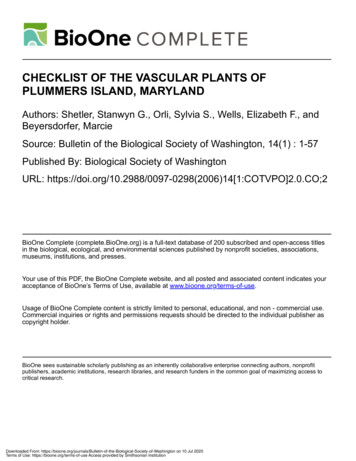
CHECKLIST OF THE VASCULAR PLANTSOF PLUMMERS ISLAND, MARYLANDStanwyn G. Shetler, Sylvia S. Orli, Elizabeth F. Wells, and Marcie BeyersdorferINTRODUCTIONPlummers Island and MainlandPlummers Island (38 58 10 N lat., 77 10 36 Wlong.) is a small wooded island in the Potomac Rivernear Cabin John, Montgomery County, Maryland(Figs. 1, 2). It is about 14.5 km (9 mi) upriver (northwest) from the White House, Washington, DC, andis just downriver from the American Legion (CabinJohn) Bridge of the Capital Beltway (I-495), whichconnects Maryland and Virginia. The island is separated from the Maryland shore by only a narrowchannel, which can be crossed at the east end onstepping stones except at high water. It lies betweenLocks 10 and 12 of the Chesapeake and Ohio (C&O)Canal (Figs. 3, 4). In the past the island’s name wasoften written with an apostrophe, Plummer’s.The island itself consists of only 4.8 ha (12 acres),but it has been well known to local biologists for overa hundred years, thanks to studies there fostered bythe Washington Biologists’ Field Club (WBFC) sinceit first leased the island from the owner in 1901(WBFC Web site, . The Club purchased itin 1908, along with ca. 14.2 hectares (35 acres) ofthe ‘‘mainland,’’ as the land between the island andthe canal was dubbed by the early members. To thiswas added the Barton tract of ca. l.4 hectares (3.5acres) in 1924, for a total of 15.6 hectares (38.5acres) of mainland. The Leland Barton tract extendedthe Club’s mainland holding between the C&O Canaland the Potomac River eastward from Rock Run toLock 10.Access to the island at times of high water requiresa small boat, and for many years the Club has hadits own boat for ferrying its members the short distance across the channel to and from the island forits annual fall and spring outings on the island. Fromtime to time a dock has been constructed on one orboth sides, referred to as the ‘‘ferry’’ dock, but sooner or later flooding has always destroyed it.Ownership of the island and mainland propertypassed to the National Park Service through a seriesof steps in 1958–1961, and the property later becamepart of the new C&O Canal National Historical Park(NPS), opening the island to public access. In return,the Club received a settlement sum from the U.S.government, which it invested, and an agreementwith the NPS that the Club could continue to do research on the island and adjacent mainland and tomaintain and use the cabin (Figs. 5, 6) it had builton the island in 1901 as the ‘‘Clubhouse’’ for Clubfunctions. The island was dubbed Winnemana, meaning ‘‘beautiful island’’ in a local Indian language, andthe cabin, Winnemana Lodge. Each year some of theincome from the investments is used to support research on the island or elsewhere in the DC areawithin the Potomac drainage.The island is elongate and tadpole-shaped; its longaxis is oriented more or less east-west, with the westor upstream end being the broad, blunt end. It is highcentered and rocky with large boulders outcroppingat various places and a narrow primary floodplainand/or mudflats around parts of it. There is an abrupt,high outcrop (‘‘Rock of Gibraltar’’) at the west end,and there are two high knolls in the center that arethinly covered with soil and drop down to floodplainwith varying degrees of steepness. The elevation atthe top of the higher knoll, where the cabin is built,is over 36 m (120 ft) above sea level and about 20m (some 60 ft) above the river level. Parts of thenorth and south sides are rock cliffs. The top of theother knoll is about 3 m (10 ft) lower. The outcropping rock is granitic gneiss, which also outcrops onthe mainland (Erwin 1981).The mainland parcel, lying between the towpath ofthe C&O Canal on the north and the Potomac Riveron the south and somewhat surpassing the island atboth ends, was acquired and fenced (McKenny &Ricker 1937) to protect the island from encroachmentand to preserve access, and it was actively used in anumber of ways in the early years (see below). Killipand Blake (1935, 1953), following Club tradition, included the mainland in their study of the PlummersIsland flora, but starred (*) the species found only onthe mainland. At almost 16 ha, it is more than threetimes larger in area than the island itself. The highestpoint is a knoll as high as the highest point on theisland.History of Floristic StudyFrom the outset, the Club has encouraged and sponsored research on the flora and fauna of the island andadjacent mainland, and many scientific papers haveresulted to date, including a series of 29 papers underthe general heading ‘‘Natural History of Plummers Island, Maryland.’’ Twenty-five of the 29 have beenpublished in the Proceedings of the Biological Societyof Washington. One was published as a Special Publication and three as two Bulletins of the BiologicalSociety of Washington. Many other papers dealing atleast in part with the island have been published elsewhere (see WBFC web site, www.pwrc.usgs.gov/Downloaded From: ical-Society-of-Washington on 10 Jul 2020Terms of Use: https://bioone.org/terms-of-use Access provided by Smithsonian Institution
Fig. 1. Map of Plummers Island and Mainland, Montgomery County, Maryland. Original property of Washington Biologists’ Field Club (WBFC) was bounded on the south side by thePotomac River. Boundaries on east, west, and north sides are shown by thin solid line running along Chesapeake and Ohio (C&O) Canal and towpath between Locks 10 and 12 and then towardriver (south) from these locks. Dotted lines represent paths. Numbers 1–22 refer to collecting sites (see p. 22).2BULLETIN OF THE BIOLOGICAL SOCIETY OF WASHINGTONDownloaded From: ical-Society-of-Washington on 10 Jul 2020Terms of Use: https://bioone.org/terms-of-use Access provided by Smithsonian Institution
NUMBER 14Fig. 2.3Aerial photograph of Plummers Island and vicinity. Photo courtesy of U.S. Geological Survey.Fig. 3. C&O Canal and towpath along south side of Canal near Lock 11, looking upstream (west). Towpath forms northern boundaryof original Mainland property of WBFC. Path to Plummers Island cuts off to left just before towpath rises to top of lock. Photo by W.J. Kress.Downloaded From: ical-Society-of-Washington on 10 Jul 2020Terms of Use: https://bioone.org/terms-of-use Access provided by Smithsonian Institution
4BULLETIN OF THE BIOLOGICAL SOCIETY OF WASHINGTONFig. 4.Narrow Channel of Potomac River between Mainland (right) and Island, looking upstream (west). Photo by W. J. Kress.resshow/perry/bios/WBFCHome.htm, BiologicalStudies).The first specimens known to have come fromPlummers Island were collected by a number of persons in the late 1890s, before the WBFC was involved with the island. Waldo McAtee (McAtee file,WBFC archives) alludes to collections as early as the1870s in his notes, but none has been seen to confirmthis. Once the Club established its headquarters onthe island in 1901, collections began to accumulateand the herbarium of vascular plants was kept conveniently on the island in the cabin. A running listof species identified on the island and the mainlandwas maintained in a card file. By 10 August 1912,this totaled 538 species, according to a list copiedfrom the card file at that time, apparently by McAtee,entitled ‘‘Spermatophyta of Plummer’s Island, Maryland’’ (McAtee file, WBFC archives). The herbariumand the card file were still housed in the cabin as lateas 1937 (McKenny & Ricker 1937), but at some timeafter that they were moved to safety at the Smithsonian Institution, presumably because of the growing threat of theft and vandalism. There the herbarium and associated card file have remained.Up to the present, at least 67 persons have contributed one or more specimens to the Plummers Island Herbarium. Of these, 13 collected 100 or morespecimens, six collected 300 or more, and only three(Fig. 7) collected 500 or more—Ellsworth P. Killip(847), Albert S. Hitchcock (597), and Emery C.Leonard (578). Neil Hotchkiss, with 477, was not farbehind (Fig. 7). Nearly half, 31, of the 67 collectorshave been members of the WBFC, and 25 of the 31have been botanists. Since some 65 botanists (exactnumber depending on definition of ‘‘botanist’’) havebelonged to the WBFC during the course of its longhistory, this means that fewer than half of them havecontributed specimens to the Plummers Island collections over the years.Three of the most important collectors and students of the Plummers Island vascular flora were Killip (1890–1968), Leonard (1892–1968), and Hotchkiss (1901–1994), whose collecting activities on theisland spanned 41 (1915–1955), 45 (1921–1965), and49 (1917–1965) years, respectively. Sydney F. Blake(1892–1959; Fig. 7) also stands out, not for his collecting but for his collaboration with Killip to publishthe ‘‘Flowering Plants and Ferns’’ in 1935. That paper, the second contribution (No. II) to the WBFC’sseries on the Natural History of Plummers Island initiated that year, followed a short introductory paper(No. I, Maxon 1935) and was really the first researchcontribution to the new series. It was also the firstand, until now, has been the only catalog of the vascular flora of the island and adjacent mainland to bepublished in the Club’s 100-year history. In 1953,Downloaded From: ical-Society-of-Washington on 10 Jul 2020Terms of Use: https://bioone.org/terms-of-use Access provided by Smithsonian Institution
NUMBER 145Fig. 5. North side of Plummers Island in winter, looking southwest across Channel from Mainland through floodplain forest to High(Cabin) Knoll. Photo by W. J. Kress.Killip and Blake published what proved to be theonly supplement to their checklist—‘‘FloweringPlants and Ferns—Supplement 1’’ (No. X in NaturalHistory series).Collecting has gone in cycles through the years.Extensive collecting was done in the early years ofClub ownership and especially in the 1930s beforeand after the Killip and Blake checklist appeared. Inthe more than 50 years since their supplement waspublished there have been four major cycles. Hotchkiss and Leonard made many collections in 1960–1961, and in 1982–1986 Beyersdorfer systematicallycollected the non-graminoid flora on behalf of Shetlerin anticipation of this present study. In 1997–1998,Wells and her students, Rebecca L. Brown and Venkat S. Murthy, did extensive documentary collectingin their study of changes in the floodplain vegetationof the island. In a new (2003–2005) cycle of collecting and sight-recording, Shetler, Orli, Wells, W.John Kress, and others have attempted to establishthe present flora. Kress and coworkers have also beendocumenting their feasibility study (‘‘An ElectronicField Guide: Plant Exploration and Discovery in the21st Century’’), begun in 2004 and focused on theisland. This project also includes a pilot study of thefeasibility of DNA barcoding in flowering plants(Kress et al. 2005). All of these collections have beendeposited in the Plummers Island Herbarium.There is a problem with the date of collection given, 9 May 1961, on the labels of 149 of the specimens of Hotchkiss and Leonard. Many of theseplants clearly could not have been collected so earlyin the growing season; they were far too advanced intheir development. There is no apparent reason, however, to suspect other data on these labels.Since being moved to the Smithsonian Institution,the Plummers Island Herbarium, a collection nownumbering over 3500 specimens, has always beenkept separate from the general collection of the U.S.National Herbarium (US) in the National Museum ofNatural History. It is maintained as a separate part ofthe Herbarium of the Washington-Baltimore Area(‘‘District of Columbia’’ or ‘‘DC’’ Herbarium). ThePlummers Island Herbarium, as also the entire DCHerbarium, can be searched and consulted on-linethrough the web site of the Flora of the WashingtonBaltimore Area (persoon.si.edu/dcflora) by using‘‘Plummers Island’’ as the ‘‘Locality.’’Downloaded From: ical-Society-of-Washington on 10 Jul 2020Terms of Use: https://bioone.org/terms-of-use Access provided by Smithsonian Institution
6BULLETIN OF THE BIOLOGICAL SOCIETY OF WASHINGTONFig. 6. Cabin built by WBFC in 1901 on top of High Knoll, highest point of Island. Now amid oak-hickory-sugar maple uplandforest. Photo by W. J. Kress.The nonvascular plants, as traditionally circumscribed, have been the subject of a number of papers.In the ‘‘Natural History of Plummers Island’’ seriesare lists of Mosses by Leonard (1935), Fungi by Stevenson and Ermold (1936), Hepaticae by Leonardand Pierce (1939), Lichens by Leonard and Killip(1939), and Blue-green Algae (Myxophyceae) byDrouet (1954). These lists are now very dated andhave not been followed up by further surveys. Morerecently, however, Hale (1970, 1972, 1979) and Lawrey and Hale (1977, 1981) published on lichengrowth and stress from automobile pollution onPlummers Island. They studied the lichens on CactusRock (Figs. 8, 9) and showed that after the AmericanLegion Bridge was built for the Capital Beltway (I495) automobile emissions stressed the lichens andreduced their growth. Comparable studies have notbeen done to examine the effect, if any, of air pollution on the vascular plants of the island.As an interesting botanical sidelight of theWBFC’s early years on the island, McAtee recordedin miscellaneous notes (McAtee file, WBFC archives) that in June 1918 the Club granted MaryVaux Walcott use of the island for six months for hersketching of wild flowers. Presumably, ‘‘use’’ meantright of access, but this is not clear. Mary Walcottwas the wife of Charles D. Walcott, fourth Secretary(1907–1925) of the Smithsonian Institution. Shegained fame for her 400 watercolors of North American wild flowers, sumptuously published by theSmithsonian in five volumes (Walcott 1925). Othernotable early visitors to the island included Louis Agassiz Fuertes and Theodore Roosevelt (McKenny &Ricker 1937).Changing Vegetation Cover and FloraThe topographic relief, with mudflats, floodplain,and various slopes and rocky outcrops, has affordeda variety of habitats on the island despite its smallsize. Over the years, repeated high water and floodingon the lower parts have brought repeated cycles ofscouring and deposition and in the process periodicrenewal of the mudflat and floodplain flora (Figs. 10,11). The floodplain is quite sandy in places, especially toward the east (downstream) end. At one timeit included a small pond at the west end and a smallmarsh below Cabin Knoll (Erwin 1981). A smallmarshy area still exists on the northwest corner ofthe island.The constant changes of the floodplain habitats nodoubt account in significant measure for the relativelyDownloaded From: ical-Society-of-Washington on 10 Jul 2020Terms of Use: https://bioone.org/terms-of-use Access provided by Smithsonian Institution
NUMBER 147Fig. 7. Important early botanists who collected and studied the Plummers Island flora. Top, left to right, Sydney F. Blake (1892–1959), Albert S. Hitchcock (1865–1935), Neil Hotchkiss (1901–1994); bottom, left to right, Ellsworth P. Killip (1890–1968), Emery C.Leonard (1892–1968). Photos from Washington Biologists’ Field Club (WBFC) archives, courtesy of M. C. Perry.large cumulative flora recorded for the island and formany of the apparently transitory accidentals. According to Maxon (1935), for instance, in the summerof 1930 the water was unusually low, and Killip recorded ‘‘numerous aquatic and shore plants.’’ In their1953 supplement to the their earlier checklist, Killipand Blake noted that nearly two-thirds of the 128species being added to the flora were collected inl936 and 1937, ‘‘following the disastrous floods ofthose years.’’ Their commentary continues:‘‘In the low-lying parts at the upper end of the Island and alongthe channel many of the trees and shrubs and much of the topsoil were swept away. Seeds brought in with deposits of siltand sand had an abundance of sunlight and air in which togerminate, and constant collecting by members of the Club ledto the discovery of a surprisingly large number of novelties.’’Of the accidental floristic element that likely wasbrought in by the river over the years, the most notable member is Iresine rhizomatosa Standl. (bloodleaf) of the amaranth family (Amaranthaceae). Asoutheastern plant of low wet woodlands, it was described as a species separate from I. celosioides L.( I. diffusa Humb. & Bonpl. ex Willd.) by P. C.Standley (1915) on the basis of specimens collectedby him on the island that year. It had been collectedthere several times before, but his was the last collection ever to be made on the island. At that time,he reported, there were ‘‘numerous’’ plants in ‘‘several colonies,’’ although only two or three were inflower. Just when it disappeared is not documented,but the species has long been gone from the island.The Iresine is one of at least three species thatwere new to the flora of the whole District of Columbia area when first discovered on the island, the othertwo being Crepis pulchra, small-flowered hawksbill,and Verbascum phlomoides, clasping-leaved mullein.The vegetation cover of the island has become lessopen over the years. Today, the island is covered witha relatively dense tree canopy (Figs. 12–14), but earlyphotographs (Fig. 15) show an island that, althoughforested, must have been cut-over in the 1800s, because, particularly on the uplands, tree cover wasvery thin when the Club acquired the island (Erwin1981). Juniperus virginiana (eastern red-cedar), asuccessional pioneer of old fields and open dry land,was a prominent tree on the highest parts, where itwas scattered. Most of the red-cedar trees are gonenow and have been replaced by various deciduousspecies, notably maples, hickories, and oaks.Downloaded From: ical-Society-of-Washington on 10 Jul 2020Terms of Use: https://bioone.org/terms-of-use Access provided by Smithsonian Institution
8BULLETIN OF THE BIOLOGICAL SOCIETY OF WASHINGTONFig. 8. Cactus Rock, looking upriver (west) along the Potomac River where the American Legion Bridge now crosses from Maryland(right side) to Virginia (left side), 1908 or 1909. Photo by H. S. Barber, from WBFC archives.The gradual closing of the canopy layer obviouslyhas changed the habitats and, accordingly, has beenaccompanied by changes in the understory and theground flora. This succession has given rise to a relatively diverse cumulative flora over the last century.As for the flora extant at any one time, however, thetrend clearly has been toward a reduction in diversityon the island, given the ever denser canopy. Thesame can be said for the trend on the mainland, asthe open, cultivated parts, with all their possibilitiesfor accidental introductions, have returned to closedforest (see below).The loss of open habitat and consequent reductionin diversity are apparent when the present Checklistis compared with the earliest known list of the vascular plants, McAtee’s unpublished ‘‘Spermatophytaof Plummer’s Island, Maryland,’’ dated 10 August1912, which was mentioned earlier (McAtee file,WBFC archives). It enumerates 538 native (mostly)and naturalized species, as compared to the 300 orso species that are extant today. A surprising numberof the plants on that early list are among the 300 stillthere, over a hundred years later. Of the species onthe early list that no longer are present, many aretypical of open country. In some cases, alien specieshave out-competed their native counterparts over theyears. For example, the early list includes the nativeCelastrus scandens, American bittersweet, and thenative Humulus lupulus, common hop, but today theyappear to have been replaced entirely by the aliensCelastrus orbiculatus, oriental bittersweet, and Humulus japonicus, Japanese hop, neither of which ismentioned in McAtee’s list.His list includes about 40 species (exact numberdepends on nomenclatural interpretations) that lackvoucher specimens and were never verified and in-Downloaded From: ical-Society-of-Washington on 10 Jul 2020Terms of Use: https://bioone.org/terms-of-use Access provided by Smithsonian Institution
NUMBER 14Fig. 9.archives.9Opuntia humifusa (Raf.) Raf. (eastern prickly-pear) colony on Cactus Rock, 1908 or 1909. Photo by H. S. Barber, from WBFCcluded by Killip and Blake (1935, 1953), hence theyare not included in our Checklist. The card file, surelyknown and available to them, was probably a compilation of field-identified species, and some of thespecies in the list are questionable in light of what isknown today about the region’s flora. Many of the40 or so species are weedy in nature and typical offields, meadows, openings and edges, or disturbedareas. They may have been so transient that theywere long gone without verifiable documentation bythe time Killip and Blake put together their list(1935). Also, it is not always clear whether McAteewas including some species from across the river inVirginia or other nearby locales.The Opuntia humifusa (eastern prickly-pear) is oneof perhaps many species that have disappeared fromDownloaded From: ical-Society-of-Washington on 10 Jul 2020Terms of Use: https://bioone.org/terms-of-use Access provided by Smithsonian Institution
10BULLETIN OF THE BIOLOGICAL SOCIETY OF WASHINGTONFig. 10. East end of Island with large sign identifying Island and briefly explaining long-term studies by WBFC. Facing south towardriver and Virginia shore. Photo by E. Lohnes.the island in the last hundred years in all likelihoodbecause of the closing canopy, although other factorssuch as human disturbance and predation and evenair pollution may have contributed to their disappearance. Specimens and photographs preserved inthe Plummers Island Herbarium show that a largecolony of this cactus flourished in the early 1900s onthe large boulder that became known as Cactus Rock(Figs. 8, 9), which is just downslope from the crestof the high knoll. Curiously, the cactus is not inMcAtee’s list of the spring flora on the island in1912, perhaps because it was not yet in flower whenthe list was made (McAtee file, WBFC archives). Thelast collection was made in 1915, and the cactus wasstill present in the mid-1930s. There are no recordsto show how long the cactus persisted. Several persons recall seeing remnant plants in the 1960s andeven as recently as the early 1980s, but there are nosupporting specimens or other records. Such a conspicuous species would hardly have been overlookedor ignored by collectors in the 1960s and later. CactusRock, when it was much more exposed, was a prominent, accessible high vantage point to which hikerswere easily attracted. Thus, in addition to increasingshade, trampling likely took a toll and maybe collecting for gardens, as well. Certainly, foot traffic increased as the island became more accessible to thepublic through the years, especially after becomingpart of the C&O Canal National Historical Park.When the land was purchased, the mainland parcel, with its three or four small woodland pools,swampy area, and cleared plots, added significantlyto the habitat and species diversity of the island. Today, the open areas are gone, and the property ingeneral is heavily wooded. The pools, now in themiddle of relatively mature forest, may be little morethan wet areas in summer.The mainland property had long been subjected todisturbance before purchase, which was continuedfor a time by the Club. Over a third of the property,more or less surrounding the Lock House exclosureat Lock 11, was open land that had been in agricultural use, perhaps in connection with the Lock House.Club members did a little gardening there during waryears, and at times the Club leased it to residents ofthe Lock House for agricultural purposes (WBFCweb site, www.pwrc.usgs.gov/resshow/perry/bios/WBFCHome.htm, Biological Studies). Eventually,the cultivated areas of the mainland were left to revert to forest, and the vegetation cover has graduallybecome more homogeneous. Although the LockHouse has not been occupied for many years, theNPS still keeps open the small grassy clearing aroundit. The elimination of cultivation in time largely elim-Downloaded From: ical-Society-of-Washington on 10 Jul 2020Terms of Use: https://bioone.org/terms-of-use Access provided by Smithsonian Institution
NUMBER 14Fig. 11.11A spring flood of 2005 submerging east end of Island and nearly covering sign in Fig. 10. Photo by N. Bourg.inated the open and edge habitats and with them thepotential for accidental introductions through agriculture. Just how many, if any, of the species in theChecklist were introduced incidental to cultivationand have since disappeared is unknown.Finally, in recent years heavy and ever increasingbrowsing by white-tailed deer on both the island andthe mainland are having a growing impact on thevegetation, such that more and more herbaceous species (e.g., Impatiens capensis, orange jewelweed) areunable to mature and produce seeds and may eventually die out. In fact, it is likely that some specieshave already been extirpated by the deer, but this isdifficult to determine.Present Plant CommunitiesThis section is a general account of the plant communities of Plummers Island by Wells, based on detailed plot studies principally of the floodplain vegetation made by her on the island during the growingseason of 1997 with the assistance of Brown andMurthy.Plummers Island’s varied topography supportsthree main types of plant communities: riparian, terrace, and upland forest. The riparian communitieshave relatively low topographic relief, occur at thelower elevations along the river, and are flooded fre-quently, from several times a year to once every 2–3years (Figs. 10, 11). They are dominated by a richflora of species typically associated with floodplains,such as Platanus occidentalis (sycamore), Acer saccharinum (silver maple), A. rubrum (red maple), A.negundo (boxelder), Fraxinus pennsylvanica (greenash), Ulmus rubra (slippery elm), Juglans nigra(black walnut), Lindera benzoin (spicebush), andmany other species tolerant of flooding. Sycamore,green ash, boxelder, and slippery elm form a closedcanopy throughout the island’s floodplain, and Asimina triloba (pawpaw) is conspicuous in the ripariansub-canopy over much of the island. Parthenocissusquinquefolia (Virginia-creeper), Vitis aestivalis (summer grape), V. vulpina (winter grape), and Toxicodendron radicans (poison-ivy) are common vinesthroughout the island. A few non-native invasive species such as Alliaria petiolata (garlic-mustard) andLonicera japonica (Japanese honeysuckle) are common throughout most of the floodplain; Conium maculatum (poison-hemlock) and Celastrus orbiculatus(oriental bittersweet) are conspicuous in some areas.The herbaceous vegetation of the riparian communities varies with habitat, soil depth, and floodingfrequency. The floodplains on the lower end and atthe head of the island are relatively broad and gentlyrolling. The deep sandy soil is redeposited by rapidlyDownloaded From: ical-Society-of-Washington on 10 Jul 2020Terms of Use: https://bioone.org/terms-of-use Access provided by Smithsonian Institution
12BULLETIN OF THE BIOLOGICAL SOCIETY OF WASHINGTONFig. 12.Upland forest in early spring on south slope of High Knoll, looking toward Virginia shore. Photo by N. Bourg.Downloaded From: ical-Society-of-Washington on 10 Jul 2020Terms of Use: https://bioone.org/terms-of-use Access provided by Smithsonian Institution
NUMBER 14Fig. 13.13Understory vegetation in summer on terrace below High Knoll. Photo by W. J. Kress.flowing water during floods, leaving bare sand whichis quickly revegetated by opportunistic herbaceousplants. The lush herbaceous layer here is composedof Allium tricoccum (native ramp), Phlox divaricata(wild blue phlox), Verbesina alternifolia (wingstem),and V. occidentalis (southern flatseed-sunflower), andthe non-natives Artemisia annua (annual wormwood), Polygonum ce
OF PLUMMERS ISLAND, MARYLAND Stanwyn G. Shetler, Sylvia S. Orli, Elizabeth F. Wells, and Marcie Beyersdorfer INTRODUCTION Plummers Island and Mainland Plummers Island (38 58 10 N lat., 77 10 36 W long.) is a small wooded island in the Potomac River near Cabin John, Montgomery County, Maryland (Figs. 1, 2). It is about 14.5 km (9 mi) upriver (north-
