Transcription
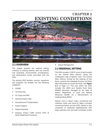
CHAPTER 2EXISTING CONDITIONS2.1 OVERVIEW This chapter presents the regional setting,inventory of existing facilities, land use controlsand ownership, environmental considerations,and development trends associated with theOGG.2.2 REGIONAL SETTINGThe existing OGG facilities, services, operationsand programs are divided into the followingcategories: AirfieldTerminal AreaAir Cargo and MailGeneral Aviation (GA)Access/Ground TransportationAirport SupportAirport IndustrialAirport ManagementThe OGG occupies 1,540.51 acres of land locatedon the Central Maui isthmus, along thenortheastern side of Kahului Town. The CentralMaui isthmus, formed by the meeting of lavaflows, connects the Haleakalā Volcano and WestMaui Mountains by broad flat lands. See Figure1-1 on Page 2-2. The area within the OGGincludes the 246.9 acre Kanahā Pond StateWildlife Sanctuary, managed by the State ofHawai‘i Department of Land and NaturalResources (DLNR) via a Memorandum ofUnderstanding (MOU).Kahului Town is Maui’s major commercial andindustrial center and home to Maui’s principalcommercial harbor and the OGG. Kahului is alsocomposed of residential neighborhoods withlarge suburban lots and wide curvilinear streetsAirspace, Airport Traffic Control (ATC) &Noise Abatement ProceduresKahului Airport Master Plan Update2-1
Figure 2-1 Location MapSource: ESRI, Digital Globe, GeoEye, Earthstar Geographics, CNES/Airbus DS, USDA, USGS, AEX, Getmapping, Aerogrid, IGN, IGPswisstoppo, and GIS User Communitythat are separated from the commercial andindustrial uses in the area.Land uses surrounding the OGG include singlefamily residences to the north; single-familyresidences and active agricultural lands to theeast; the Hāna Highway, the Haleakalā Highway,and active agricultural lands to the south; andKahuluiHarbor,WailukuWastewaterReclamation Facility, Kanahā Beach Park, andlight industrial, commercial, and retail uses tothe west.2.3 INVENTORY OF EXISTINGFACILITIESTwo (2) runways serve the airport: Runway 2-20and Runway 5-23. See Figure 2-1 and SectionKahului Airport Master Plan Update2.3.3 on Page 2-5 for a discussion on Runway 523.The facilities located west of Runway 2-20include: Main Passenger TerminalCommuter Airline TerminalAirline OfficesAir Cargo FacilitiesAirline Ground Maintenance FacilitiesDOTA Maintenance BaseyardGround Transportation SubdivisionARFF Training FacilityAirport Industrial AreaThe facilities located east of Runway 2-20include:2-2
GA Area Aircraft Rescue and Fire Fighting (ARFF)Facility FAA Airport Traffic Control Tower (ATCT)Based and Itinerant Aircraft Parking ApronThe OGG’s two (2) runways, Runway 2-20 andRunway 5-23, intersect at the northern end ofthe airfield. Information on their physicalcharacteristics is summarized in Table 2-1 onPage 2-5.Fixed Base Operator (FBO) Area2.3.2 RUNWAY 2-20Aircraft Maintenance FacilitiesHangarsHelicopter and Air Taxi Facilities IncludingScenic Air Tour Operations2.3.1 AIRFIELDRunway 2-20 is 6,995 ft. long, 150 ft. wide, andconstructed of grooved asphalt with 35 ft. widestabilized asphalt concrete (AC) shoulders. TheRunway Safety Area (RSA) is 500 ft. wide andextends 1,000 ft. in both directions beyond theends of the runway. Elevations at Runway 2-20ends are 54 and 12 ft., respectively, above MeanSea Level (MSL). The average gradient fromnorth to south is 0.59%.According to the National Plan of IntegratedAirport Systems (NPIAS) the OGG would beclassified as a Primary, Medium Hub airport. APrimary airport is defined as having more than10,000 passenger enplanements each year. AMedium Hub airport is defined as havingbetween 0.25 and 1.0 percent (%) of the totalannual passenger boardings within the U. S. inthe current fiscal year.Runway 2 has an Instrument Landing System(ILS), Medium Intensity Approach LightingSystem with Runway Alignment Indicator Lights(MALSR), and Visual Approach Slope Indicator(VASI-4), while Runway 20 has PrecisionApproach Path Indicator (PAPI-4) approach aids.In addition, Runway 2 has High-Intensity RunwayLights (HIRL), while Runway 20 has MediumIntensity Runway Lights (MIRL).Aircraft in use at the OGG are classified by theFAA in AC 150/5300-13A Airport Design (2014),as Aircraft Approach Categories (AAC) C or D(i.e., aircraft with approach speeds of 121 to 165knots, inclusive). Examples of Category C and Daircraft include the B-737, B-747, B-757, B-767,B-777, A-330, and most business jet aircraft.Runway 2-20 ReconstructionThe relationship of these facilities to each otheris shown on Figure 2-1 on Page 2-2.The OGG is primarily used by aircraft in theAircraft Design Group (ADG) III with wingspansranging from 79 feet (ft.) to 117 ft. (e.g., B-717and B-737). It is also frequently used by aircraftsuch as the B-757 and B-767 that are in ADG IV.Aircraft in ADG V (i.e., B-747 and B-777) andADG VI (i.e., C-5A) occasionally use the OGG buttheir operations account for an insignificantpercentage of total operations. Between 2010and 2015 the OGG had 118,896 and 123,587aircraft operations respectively.Runway 2-20 serves as the OGG’s primaryrunway. This runway is currently experiencingpavement distress and is in need ofreconstruction.Pavement distress results in increased ACdeterioration in the form of cracks, jointdeterioration, and other forms of pavementstresses. Although the runways at OGG are safein their current condition, because of recentresurfacing, this has led to a slow but steady risein the presence of foreign object debris (FOD).FOD has the ability to severely damage aircraftwhen there is an accidental intake of FOD intojet aircraft engines. The rise in FOD has led OGGstaff to increase safety inspections prior to thedeparture of aircraft.In 2008, the DOTA investigated this issue andcommissioned two separate reports that hadKahului Airport Master Plan Update2-3
similar findings concerning the cause of thepavement distress.The first report, Runway 2-20 and TaxiwayPavement Evaluation, Kahului, Maui, Hawai‘i, wasprepared by MACTEC Engineering andConsulting, Inc. (MACTEC) in September 2008.The report investigated pavement conditions,potential problems, and recommended possiblesolutions to repair the runway while consideringthe runway’s active use and importance to theeconomy of Maui.MACTEC indicated that the existing pavementstructure generally has about 17 inches of ACover four (4) to eight (8) inches of aggregatebase, with some areas having 14 inches of ACover nine (9) inches of base, and 16 inches of ACover eight (8) inches of base. Shear testing of thepavement indicated weak to no bonding of thelayers. The report concluded that the pavementproblems resulted from slippage between thepavement layers caused principally by thebraking and turning actions of heavy aircraftwhile slowing and exiting the runway afterlanding. The report hypothesized that “ theseparation of the layers is due to a weak bondresulting from low or weak bond strength of thetack coat.”The second report, Statewide PavementManagement System Update for Kahului Airport,was prepared by URS Corporation, Inc., 2008,and similarly concluded “ pavement distress isfrom slippage between the existing AC layerwhich is placed over the aggregate base.” Asupplemental pavement evaluation, Runway 220 & Taxiway Structural Improvements at OGG,State Project No. AM1022-14: ConcreteConstruction, URS Corporation, Inc., 2010, furthersuggested that the runway surface be convertedfrom asphalt to concrete.The prevention of FOD caused by airfieldpavement deterioration is among one of theDOTA and FAA’s top safety priorities. Since 1942when Runway 2-20 was originally constructed,there have been five (5) subsequent AC overlaysconstructed to maintain the use of the runway.Kahului Airport Master Plan UpdateThese occurred in 1969, 1972, 1981, 1995, and2000, at an overall approximate cost of 4.2 mil.Later, in 2006, a partial 3-inch AC mill andoverlayprojectwasconstructedforapproximately 3.4 mil.The need for unscheduled intermittentpavement repairs to Runway 2-20 has beenrequired since 2008. Funding for the pavementrepair was from the airports special maintenancebudget: 2008-2010, 1.3 mil. and 2011, 1 mil.Pavement distress and proposed rehabilitationand/or reconstruction are a priority concern forboth the DOTA and FAA. The intermediaterepairs undertaken over the past several yearshave provided some relief but have notaddressed the need for a permanent fix orremedy providing a durable, safe runway with adesign life of not less than 20 years. Thecontinueduseofintermediaterepairsconstitutes an inefficient use of airport funds asrecurring problems with FOD can be expected toresult in aircraft delays and a higher potential foraccidents when intermediate constructionactivities disrupt airfield operations.During the OGG MP Update, the DOTAcommissioned the Kahului Airport Runway 2-20ReconstructionFeasibilityStudy,URSCorporation, Inc., 2012, to identify and evaluatereasonable and practical alternatives for Runway2-20 reconstruction. Alternatives were evaluatedusing a three (3) step screening process that metthe following purpose and need criteria: Reconstruct Runway 2-20 at its currentlength with a 20-year pavement life. Maintain airfield capability to adequatelyaccommodate the current and projectedlevels of air carrier and cargo operations, aswell as the current and potential fleet mix oftranspacific flights.Runway 2-20 ExtensionIncreasing the operational capacity of the OGGhas been under consideration since 1993 whenthe last update of the OGG MP took place. Many2-4
of the aircraft serving OGG in the 1990s are nolonger being utilized and new markets are nowbeing served. The aircraft now serving OGG aremore efficient and larger. At its existing lengthof 6,995 ft., Runway 2-20 does not allow airlinesto operate unrestricted at maximum takeoffweight (MTOW). See Chapter 4, Section 4.3.6.8Runway Length for details. Currently, the B-737800 aircraft requires 8,400 ft. to takeoff atMTOW on a standard day 27 C with zero windand runway gradient. This is in contrast to the6,995 ft. currently available. The B-767-300requires on a similar standard day 10,600 ft. ofrunway to takeoff (Boeing, 2016).CHARACTERISTICApproach CategoryAircraft Design GroupLength (ft.)Width (ft.)Surface TypeSurface TreatmentPavement Strength- Double Dual Tandem- Dual Tandem- Dual Wheeled- Single WheeledRunway Protection ZoneDimensions (ft.)Runway Safety Area DimensionsElevations (Above MSL) (ft.)Stripping2.3.3 RUNWAY 5-23Runway 5-23 is 4,990 ft. long, 150 ft. wide, andconstructed of grooved asphalt. The RSA is 500ft. wide and extends 1,000 ft. in both directionsfrom the ends of the runway. The averagegradient from west to east is 0.08%. Runway 5has VASI-4 approach aids.Runway 5-23 primarily serves commuter andgeneral aviation traffic. Occasionally the runwayserves as a crosswind runway when there are“Kona” wind conditions from the south andsouthwest directions.RUNWAY 2-20C-DIV-V6,995 ft.150 ft.ASPH-GGroovedRUNWAY 5-23A-CI-IV4,990 ft.150 ft.ASPH-GGrooved750,000 lbs.360,000 lbs.170,000 lbs.N/A1,000 ft. x 1,750 ft.N/A270,000 lbs.170,000 lbs.130,000 lbs.500 ft. x 1,010 ft.500 ft. x 1,000 ft.54/12 ft. MSL.Precision Approach500 ft. x 1,000 ft.20/16 ft. MSL.Non-Precision ApproachTable 2-1 Kahului Airport Runway 2-20 and Runway 5-23 DataAIRCRAFT CLASSPERCENT OF OPERATIONS BY YEAR20106535Class A and BClass C and D20146238PERCENT CHANGE-3 3Table 2-2 Percent of Total Aircraft Operations 2010 and 2014RUNWAY220523PERCENT OF OPERATIONS BY AIRCRAFT APPROACH CATEGORYA and B6.70.740.75.3C and D40.95.60.10.0Table 2-3 Percent Aircraft Utilization by RunwayKahului Airport Master Plan Update2-5
TAXIWAYABCDEFGKL(Temporary)DESCRIPTIONParallel taxiway to Runway 2-20 on west side of asphalt concretepavement.Diagonal connecting taxiway from a point 2,000 ft. from the southernend of Runway 2-20 to the main passenger terminal apron andRunway 5-23.Exit taxiway at the end of Runway 2 that connects to the helicopteroperating area.Exit taxiway that connects the passenger terminal apron with Runway2-20 approximately 1,000 ft. from the southern end of the runway.The portion northwest of Runway 2-20 is a diagonal exit taxiwayconnecting the passenger terminal apron with Runway 2-20approximately 2,000 ft. from its southern end. This portion’s pavementis approximately 125 ft. wide. The portion southeast of Runway 2-20 isa diagonal exit taxiway connecting the southern end of the air taxiapron with Runway 2-20. This portion’s pavement is 75 ft. wide with20 ft. wide asphalt concrete shoulders.Exit taxiway connecting Runway 2-20 with Taxiway “B” and Taxiway“H” at the western end of Runway 5-23. A portion of the taxiwayconnects the general aviation apron with Runway 2-20. Pavementwidth is 75 ft. between Runway 2-20 and Taxiway “A,” and betweenthe GA apron and Runway 2-20; 50 ft. between Taxiway “A” andTaxiway “B”; and varies between Taxiway “B” and Runway 5-23.Exit taxiway connecting northern part of Runway 2-20 with Taxiway“A.” Pavement width varies from 125 to 400 ft.Exit taxiway connecting northern part of Runway 2-20.Taxiway parallel and east of Runway 2-20 in front GA facilities,currently “apron-edge taxiway”. This proposed taxiway will be thetemporary runway during Runway 2-20 reconstruction.WIDTH75 ft., with 25 ft.shoulders50 - 75 ft.75 ft.200 ft.75 – 125 ft.50- 75 ft.124 – 400 ft.VariesVaries 50 ft. Table 2-4 Designated Taxiways at Kahului Airport12,500 lbs. but less than 300,000 lbs.(includes B-717, B-737, CRJ passengeraircraft, C-130 military aircraft, and largerbusiness jets) and an approach speed of 121knots or more, but less than 141 knots.2.3.4 AIRCRAFT FLEET MIXThe aircraft fleet mix is the relative percentage ofoperations conducted by fixed wing aircraftwithin the following aircraft approach categories(AAC): Category A: Small single-engine aircraft witha maximum certificated takeoff weight of12,500 lbs. or less and an approach speed ofless than 91 knots. Category B: Small twin-engine aircraft(including small business jets) with amaximum certificated takeoff weight of12,500 lbs. or less and an approach speed of91 knots or more, but less than 121 knots. Category C: Large aircraft with a maximumcertificated takeoff weight greater thanKahului Airport Master Plan Update Category D: Heavy aircraft with a maximumcertificated takeoff weight greater than300,000 lbs. (includes B-757, B-767, B-777,A-330, B-747, and C-5A aircraft) and anapproach speed of 141 knots or more, butless than 166 knots. Category E: Heavy and special militaryaircraft with an approach speed of 166 knotsor more.In 1990, Category A and B aircraft comprised57.6% of operations while Category C and Daircraft comprised 42.7% of operations. In 2010,2-6
Category A and B aircraft comprised 65%ofoperations while Category C and D aircraftcomprised 35% of operations. A summary isprovided in Table 2-2 on Page 2-5, and exampleof aircraft types by AAC is provided in Figure 23 on Page 2-8.2.3.5 RUNWAY USE PATTERNSAn airport’s runway use pattern is defined by thenumber, location, and orientation of activerunways, and by the directions and types ofoperations on each runway. Runway 5-23 isutilized mainly by Category A and B aircraft.Runway 2-20 is utilized mainly by Category Cand D aircraft. Runway use percentages by typeof aircraft are summarized in Table 2-3 on Page2-5.2.3.6 ARRIVAL/DEPARTURE ANDTOUCH-AND-GO OPERATIONSHourly capacity is influenced by the splitbetween arrivals and departures. As discussed inChapter 3, peak-hour arrivals and departuresare roughly equal at the OGG. They areforecasted to remain roughly equal throughoutthe planning period. Airfield capacity is alsoaffected by touch-and-go operations by GA ns (including low approaches) accountfor about 15% of the total operations based onFAA ATCT counts. The touch-and-go operationsand low approaches at the OGG are forecast toremain constant throughout the planningperiod.Aircraft2.3.7 TAXIWAYSThe characteristics of the taxiways at OGG aresummarized in Table 2-4 on Page 2-6. Taxiways“B”, “E”, “F”, “G”, and ”K” have variable widthsranging from 50 to 400 ft. Taxiways “A” and “C”are each 75 ft. wide, while Taxiway “D” isapproximately 200 ft. wide. The apron edgetaxiway that runs parallel and east of Runway 220 is 50 ft. wide. The pavement strengths ofTaxiways “A through K” are indicated on FAAForm 5335-1 for single-wheel, dual-wheel, anddual-tandem-wheel aircraft and are 130,000,170,000, and 270,000 lbs, respectively. Thecorresponding values for portions of Taxiway “F”are 30,000 lbs., 40,000 lbs., and 65,000 lbs.,respectively (1993).2.3.8 AIRCRAFT PARKING APRONSThe OGG has several aircraft parking apronsincluding: PassengerCommuterEastThe passenger terminal apron is the main apronand is located between the passenger terminalbuilding and Taxiway “A.” The commuterterminal aircraft parking apron is locatednortheast of the commuter terminal building onthe inland side of Runway 5-23. The “East Ramp”apron (east of Runway 2-20) serves OGG basedand itinerant GA aircraft, helicopters, and air taxioperations. The characteristics of these apronsare described below.Pavement Strength CapacityMain Landing Gear ConfigurationB-777-200450,000 lbs.Triple Dual TandemB-767-300ER520,000 lbs.Single TricycleB-757-300450,000 lbs.Dual TandemTable 2-5 Pavement Strength Capacity for Passenger Terminal ApronKahului Airport Master Plan Update2-7
Figure 2-3 Aircraft Type Examples by Approach CategoryKahului Airport Master Plan Update2-8
2.3.8.1 PASSENGER TERMINAL APRONThe passenger terminal apron measuresapproximately 3,500 ft. long by 500 ft. wide. Theconcrete hardstand portion of the apron isapproximately 3,450 ft. long and 150 ft. wide,and supports 13 aircraft parking positions aspresently configured. The hardstand and apronwere expanded to serve the Alien SpeciesInspection Facility (ASIF) and air cargo facilities.The DOTA has calculated pavement strengthsbased on aircraft types for the passengerterminal apron (Hawai‘i Airports and FlyingGuide, 2012-2013). The DOTA identified thegross load capacities shown in Table 2-5 onPage 2-7 for aircraft using the passengerterminal apron2.3.8.2 COMMUTER TERMINAL APRONThe commuter terminal apron measuresapproximately 600 ft. long by 400 ft. wide. TheOGG records indicate that the apron wasdesigned to accommodate single-wheel aircraftwith gross weights up to 75,000 lbs. and dualwheel type landing gear aircraft with grossweights up to 145,000 lbs. This is more thanadequate to accommodate the type of aircraftthat currently use the commuter terminal.2.3.8.3 EAST RAMP APRONThe “East Ramp” apron consists of two distinctareas. The first area consists of the southern endof an abandoned runway (formerly Runway 1735). This area measures approximately 1,200 ft.long by 400 ft. wide and is now used forhelicopter operations. The second area parallelsRunway 2-20. It is approximately 3,400 ft. longby 200 ft. wide and is used for GA and air taxiaircraft parking. According to the latestinformation available from DOTA, the pavementstrength for single-, dual-, and dual-tandemlanding gear aircraft for most of the East Rampapron are 30,000, 40,000, and 65,000 lbs.,respectively.2.3.9 RUNWAY PROTECTION ZONESRunway protection zones (RPZ) are determinedby FAA Advisory Circular AC 150/5300-13AKahului Airport Master Plan UpdateAirport Design (2014) and are approach surfacedimensions out to the point at which theapproach surface is 50 ft. above the runwaythreshold or 50 ft. above the underlying terrain,whichever is less. The width of the runway end ofthe RPZ is determined by the most preciseapproach standard applicable to the runway. Forexample, if an Instrument Flight Rules (IFR)approach is maintained at one end and a VisualFlight Rules (VFR) approach at the other, the IFRinner minimum is applicable at both ends.Runway 2 has a precision instrument approachrequiring an inner width of 1,000 ft. at both endsof the runway. Based on the most preciseapproach procedure, only a non-precisioninstrument RPZ with a 34:1 approach slope isrequired for Runway 20. However, DOTAmaintains the more restrictive instrument RPZfor Runway 2-20. The approach surface slopesfor Runways 2 and 20 are both 50:1 for the first10,000 ft. from the runway threshold. The slopeof the remaining 40,000 ft. of these approachsurfaces is 40:1. This meets the FAA’s standardfor precision instrument approaches to runways.Runway 5-23 has only visual approaches at bothends requiring an inner width of 500 ft. andouter width of 1,010 ft. Based on the mostprecise approach procedure, only a visual RPZwith a 20:1 approach slope is required forRunway 5-23. However, DOTA maintains a morerestrictive non-precision RPZs with a 34:1approach slope for Runways 5 and 23. Thismeets the FAA criteria for non-precisionapproaches for large aircraft with visibilityminimums of more than three-quarters of a mile.Because Runway 5-23 is occasionally used by jetair carrier (inter-island) aircraft when Runway 220 is not available (e.g., when it is closed formaintenance or when crosswinds preclude itsuse), the more restrictive approach slopeprovides an added margin of safety.Existing RPZ information for each runway (e.g.,Runways 2, 20, 5, and 23) approach end is shownin Table 2-6 on Page 2-10.All of the RPZs lay entirely within the OGGproperty, except for portions of the RPZ over the2-9
Figure 2-4 Existing Airport Airfield FacilitiesRUNWAY220523TYPE OF GTH (FT.)2,5002,5001,7001,700INNER WIDTH (FT.)1,0001,000500500OUTER WIDTH (FT.)1,7501,7501,0101,010Table 2-6 Runway Protection ZonesKahului Airport Master Plan Update2-10
RUNWAYNo.APPROACH SLOPECONTROLLING OBSTACLE/OBSTRUCTIONLOCATION FROM END OF RUNWAYPRIMARY SURFACE RELATED TO EXTENDEDRUNWAY l2ThresholdElevation(AMSL)54 ft.50:148:1Stack2012 ft.50:115:1Trees52320 ft.15 ft.34:134:150:150:1BuildingNone171Approx. 9,646ft. from end(lineardistance)Approx. 515 ft. from end (lineardistance)101NOTE: Actual slope 50:1 isalong runwayTable 2-7 Comparisons of FAR Part 77 Standards for Approach Slopes with Existing ObstructionsPacific Ocean to the north and a small portionfor Runway 23 to the northeast. See Figure 2-4.2.3.10 ENCROACHMENTS ON THEBUILDING RESTRICTION LINE (BRL)The existing building restriction lines (BRL) forRunway 2-20 are 1,000 ft. to the west and 750 ft.to the east of the runway centerline. Analysis ofa recent aerial photograph of the OGG indicatesthere are a few existing intrusions into the BRLarea. These include a fueling facility occupied byBradley Pacific Aviation and a GA facilityoccupied by Air Service Hawai‘i, (Dean SakamotoArchitects LLC, 2011).The BRLs of Runway 5-23 are 553 ft. from therunway centerline. This is based on thecenterline of the taxiway serving the runway setback 400 ft. from the runway centerline and theBRL being set back 153 ft. from the taxiwaycenterline.No intrusions into the BRL have been identifiedwithin the length of Runway 5-23. However, FAAstandards (FAA AC 150/5300 13A) call for theBRL to extend past the ends of the runway to thepoint at which they intersect the RPZs. Severalrelatively new buildings located in the groundtransportation baseyard area, west of theRunway 5-23 threshold, do not meet thesecriteria. These eight (8) buildings include theDollar, National, and Thrifty buildings, as well asKahului Airport Master Plan Updateone abandoned building. Additionally, theexisting airline ground equipment maintenancebuilding penetrates the object free area and theBRL for Taxiway “F.”2.3.11 OBSTRUCTIONSA review of both the FAA Airport Master Recordand the Airport Obstruction Chart published bythe National Oceanic and AtmosphericAdministration (NOAA) was conducted toidentify obstructions as defined by FederalAviation Regulations (FAR) Part 77: “ObjectsAffecting Navigable Airspace.” FAR Part 77establishes “imaginary surfaces” related toairports and their runways. These imaginarysurfaces are used to identify obstructions. Table2-7 is a comparison of the standard FAR Part 77approach slopes and existing obstaclesobstructions in the vicinity of the OGG. This tablewill be used to update the FAA Airport MasterRecord and Airport Obstruction Chart.The Runway 2 imaginary approach surface ispenetrated by Kealoloa Ridge of the West MauiMountains. The ridge penetrates a portion of the7:1 transitional surface between eight (8) and 10miles south of the runway threshold. TheRunway 20 imaginary approach surface ispenetrated by some trees. These trees areapproximately 515 ft. off the Runway 20centerline and are subject to maintenance action2-11
on a periodic basis. Runway 5-23 does not haveobstructions.2.3.12 NAVIGATIONAL FACILITIESAND LIGHTINGThe OGG FAA ATCT operates between 6:00 AMand 11:00 PM. There is an Airport SurveillanceRadar (ASR) located on the OGG property; it iscontrolled remotely from the Honolulu Air RouteTraffic Control Center (ARTCC). The ARTCC alsoprovides radar approach/departure controlservices. The FAA radio transmitter/receiverbuilding for the ARTCC is located to the east ofRunway 2-20 near the existing ASR facility.Additionally, the OGG is equipped with a lightedwind indicator, a segmented circle, wind cones,and a rotating beacon. A non-directional beaconis located at the middle marker (identificationcall sign letters “VYI”).The OGG is equipped with a Very HighFrequency Omni-Directional Radio Range andTactical Aircraft Control Navigation (VORTAC)system, designated Maui VORTAC, to assistpilots in determining bearing relative to thefacility and azimuth. In July 1996, the MauiVORTAC was relocated adjacent to theintersection of Runway 5-23 and Runway 2-20.Runway 2-20 has precision runway markings andHIRL. Both ends of the runway are equipped withVASI-4. Runway 2 has an ILS including middleand outer markers and a MALSR.Runway 5-23 is painted with non-precisionrunway markings and is equipped with MIRL.Runway 5 has VASI approach aids.All entry/exit taxiways and parallel taxiways toboth runways are equipped with MediumIntensity Taxiway Lights (MITL).2.3.13 METEOROLOGICALCONDITIONSThe average annual temperature at the OGG is74 Fahrenheit ( F). During the summer, theaverage monthly high is 82 F and the averagelow is 70 F. Winter temperatures are about tendegrees cooler. The highest temperature onKahului Airport Master Plan Updaterecord is 90 F and the lowest is 55 F. Theaverage maximum daily temperature for thehottest month is 84 F.Rainfall at the OGG is quite low, averaging lessthan 20 inches per year. The majority of thisoccurs during the winter as large-scale frontalsystems move past the island. The RainfallFrequency Atlas of the Hawaiian Islands,published by the U.S. Department of Commerce(1962), estimates that the average 24-hourrainfall having a recurrence interval of 50 years isapproximately seven (7) inches.Winds at OGG are influenced by a variety offactors. These include: strong prevailing tradewinds; physical presence of large mountainmasses to the east (Haleakalā) and west (WestMaui Mountains) of the OGG; and nighttimedrainage winds that carry cool air from themountain slopes to the coastal areas of Kahului.These winds have a significant effect on theoperations of the OGG.Data collected at OGG between January 1970and December 1979, shows that the windcoverage for 13 knots crosswinds is 96.1% forRunway 2-20 and 98.4% for Runway 5-23. Thecombined coverage for both runways is 99.8%for 13 knot crosswinds. Larger aircraft generallyuse Runway 2 during trade wind conditions andRunway 20 during Kona wind conditions. Asimilar use pattern is exhibited by the smalleraircraft that use Runway 5-23, with Runway 5being used during trade wind conditions andRunway 23 being used when there are Konawinds. Wind direction and percentage ofoccurrence at OGG are summarized in Table 2-8on Page 2-13.Data collected by the National Weather Serviceat the OGG between 1949 and 1967 indicatesthat IFR ceiling and visibility conditions below1,000 ft. and/or three miles at the OGG occurless than 1% of the time. This value was used incalculating the airfield’s annual service volume.2-12
Daytime WindDirection/SpeedTrade windKonaNighttime WindDirection/SpeedTrade windKonaCalm1-6 knots7-10 knots 10 knots2.0%Calm8.9%6.3%1-6 knots12.2%1.8%7-10 knots65.2%3.8% 10 knots5.4%-17.1%25.4%18.8%1.6%30.7%0.9%Table 2-8 Wind Characteristics at Kahului Airport2.4 TERMINALS (SEE FIGURE 2-5)2.4.1 PASSENGER TERMINALCOMPLEXMajor passenger terminal improvements sincethe completion of the 1993 MP include arenovated ticket lobby, new passenger check-incounter spaces with 24 computerized kiosks,new baggage claim carousels, security screening,and a new generator ction (2014-2015) through the Hawai‘iAirports Modernization program are Phase 1reroofing and upgrades to security accesscontrol and closed circuit TV system. Additionalimprovements anticipated to commence within1-6 years under the Hawai‘i AirportsModernization program include new flight andbaggage information display systems, re-roofingof terminal building Phases 2 and 3, remodelingof passenger holdrooms, and a new familyrestroom. Most recently, four (4) movingwalkways have been constructed on the 2ndfloor along the concourses between Gates 22through 34. Act 158, Session Laws of Hawai‘i(SLH) 2008 designated 12.9 mil. for terminalimprovements.The passenger terminal apron can accommodateup to 20 inter-island size (B-717, B-737, and CRJ)aircraft in a single row with power-in/push backoperation. According to the Competition PlanKahului Airport, fiscal year (FY) 2011, there arecurrently nine (9) gates designated for overseas(B-737, B-757, B-767, and B-777) aircraft. Theseare gates 1, 5, 7, 23, 27, 29, 33, 35, and 39. SevenKahului Airport Master Plan Update(7) gates are currently used for inter-islandoperations. These are gates 9, 11, 13, 15, 17, 19,21 (se
System with Runway Alignment Indicator Lights (MALSR), and Visual Approach Slope Indicator (VASI-4), while Runway 20 has Precision . (HIRL), while Runway 20 has Medium Intensity Runway Lights (MIRL). Runway 2-20 Reconstruction Runway 2-20 serves as the OGG's primary runway. This runway is currently experiencing pavement distress and is in .