Transcription
Global urbanicity is associated with brain andbehaviour in young peopleJiayuan Xu1,2, Xiaoxuan Liu 3, Qiaojun Li 4, Ran Goldblatt5, Wen Qin1, Feng Liu 1,Congying Chu2, Qiang Luo6,7, Alex Ing2, Lining Guo1, Nana Liu1, Huaigui Liu1, Conghong Huang 3,Jingliang Cheng8, Meiyun Wang 9, Zuojun Geng10, Wenzhen Zhu11, Bing Zhang12, Weihua Liao13,Shijun Qiu14, Hui Zhang15, Xiaojun Xu 16, Yongqiang Yu17, Bo Gao18, Tong Han19, Guangbin Cui20,Feng Chen 21, Junfang Xian22, Jiance Li23, Jing Zhang24, Xi-Nian Zuo 25, Dawei Wang26, Wen Shen27,Yanwei Miao28, Fei Yuan29, Su Lui 30, Xiaochu Zhang 31, Kai Xu32, Longjiang Zhang 33,Zhaoxiang Ye34, Tobias Banaschewski 35, Gareth J. Barker 36, Arun L. W. Bokde 37, Herta Flor38,39,Antoine Grigis40, Hugh Garavan41, Penny Gowland 42, Andreas Heinz 43, Rüdiger Brühl44,Jean-Luc Martinot 45, Eric Artiges 46, Frauke Nees 35,38, Dimitri Papadopoulos Orfanos 40,Herve Lemaitre47, Tomáš Paus 48,49, Luise Poustka50, Lauren Robinson51, Sarah Hohmann35,Juliane H. Fröhner 52, Michael N. Smolka 52, Henrik Walter 43, Robert Whelan 53,Jeanne Winterer54,55, Kevin Patrick 56, Vince Calhoun 57, Mulin Jun Li58, Meng Liang59,Peng Gong 3,60, Edward D. Barker 51, Nicholas Clinton 61, Andre Marquand62, Le Yu 3,Chunshui Yu 1,63 , Gunter Schumann 64,65 , the CHIMGEN* and IMAGEN Consortia*Urbanicity is a growing environmental challenge for mental health. Here, we investigate correlations of urbanicity with brainstructure and function, neuropsychology and mental illness symptoms in young people from China and Europe (total n 3,867).We developed a remote-sensing satellite measure (UrbanSat) to quantify population density at any point on Earth. UrbanSatestimates of urbanicity were correlated with brain volume, cortical surface area and brain network connectivity in the medialprefrontal cortex and cerebellum. UrbanSat was also associated with perspective-taking and depression symptoms, and thiswas mediated by neural variables. Urbanicity effects were greatest when urban exposure occurred in childhood for the cerebellum, and from childhood to adolescence for the prefrontal cortex. As UrbanSat can be generalized to different geographies, itmay enable assessments of correlations of urbanicity with mental illness and resilience globally.Mental disorders account for 28% of non-communicabledisease burden1. Environmental factors account for upto 50% of the attributable risk for mental disorders2. Theenvironmental measures investigated in mental health researchinclude not only individual life events3, such as trauma, abuse,neglect or psychosocial stress, but also, albeit to a lesser extent, individual physical environments4.Urbanicity, the living conditions particular to urban areas, isamong the most important environmental challenges globally5.While physical environments are hallmarks of a city, urbanicityalso includes the social environment and access to health and socialservices5. The physical, social and service dimensions of urbanicityform a complex relation with each other that has hitherto preventedthe development of a unifying concept and measure of urbanicity5.In 1950, less than 30% of the world’s population lived in urbanareas, but this fraction has increased to 55% presently and isexpected to rise to 68% in 2050 (ref. 6). While Europe is among themost stable urbanized regions, Asia is home to 54% of the world’surban population and subject to massive demographic changes.For example, by 2050, China will have added 255 million urban*A full list of affiliations appears at the end of the paper.NATuRE HuMAN BEHAVIOuR www.nature.com/nathumbehavdwellers7. This increasing global urban population emphasizes theimportance of investigating how the living conditions particular tourban areas affect human brain and behaviour.We were interested in investigating the relation of urbanicity with brain and behaviour in different sociocultural conditionsand geographies. We also aimed to identify possible susceptibility periods across the life span in young people, enabling targetedpreventions when the developing brain may benefit most fromenvironmental modification. Whereas there might be distinct influences of increased population density in urban settings in differentsociocultural conditions and geographies, there are likely to existcommon associations with brain and behaviour shared in differentareas of the globe.Several studies have focused on the relation of individual physical environments linked to urban living with brain and behaviour,such as green space, air and noise pollution4,8. However, a more general measure of urbanicity that can objectively assess urban environment with high spatiotemporal resolution and coverage is stilllacking. Such a general measure is important, as it registers the overall and susceptibility period relations of urbanicity with brain and
ARTICLESbehaviour, and may in a subsequent step enable the identificationand ranking of the individual features of the physical, social andservice environment, and their interactions, that contribute most tothe observed relation.Traditionally, characterization of urbanicity was carried outusing census data, which are ascertained infrequently in differentways and at different times in different countries5. Thus, censusdata are less useful for comparing urbanicity across different countries. More recently, the Global Human Settlement Layer (GHSL)has provided globally standardized human settlements, includingurbanization and urbanicity9. GHSL data, however, are only available at large and infrequent intervals, namely 1975, 1990, 2000 and2015 (ref. 9).To facilitate global comparative analyses of the overall relationsof urbanicity with brain and behaviour and to identify potentialsusceptibility periods, dense quantitative and longitudinal environmental measures that can be obtained from different geographies arerequired. Remotely sensed satellite data provide globally standardized quantitative environmental measures enabling the tracing ofenvironmental features going back nearly 50 years (ref. 10). Populationdensity is a well-established and quantifiable general measure ofurbanicity that is frequently applied for neighbourhood classification and used around the globe9. Here, we aimed to use populationdensity as a general measure of urbanicity to investigate whether theurban environment is correlated with brain and behaviour, and ifthese correlations are comparable in China and Europe. Specifically,we developed a satellite-based measure of population density termed‘UrbanSat’, and applied it in China and Europe to investigate therelation of population density, as a proxy of urbanicity, with brainstructure, function and behaviour in two neuroimaging datasetsof young people: as an exploration dataset, we used the ChineseCHIMGEN cohort (www.chimgen.tmu.edu.cn)11, and as the replication dataset, we used the European longitudinal IMAGEN cohort(www.imagen-europe.com)12. While we did not have any a priorihypothesis, we were interested in investigating whether: (i) UrbanSatis associated with brain structure, function and behaviour; (ii) brainfeatures associated with UrbanSat mediate the association betweenUrbanSat and behaviour; (iii) correlations of UrbanSat with brainand behaviour are similar in Chinese and Europeans; Furthermore,we were interested in (iv) identifying susceptibility periods for therelations of UrbanSat during child and adolescent development withbrain and behaviour. A schematic summary is shown in Fig. 1.ResultsDemographics. We recruited young-adult participants with lifetime residential geographies from CHIMGEN (n 3,306) andIMAGEN second follow-up (FU2) (n 561). Detailed inclusion andexclusion criteria are presented in Supplementary Tables 1 and 2.Demographics of the samples used in statistical analyses and sampleattrition are described in Supplementary Table 3 and Extended DataFig. 1. Demographic comparisons between the analysed sample andtotal sample are shown in Supplementary Table 4. Demographicvariables showing significant differences between the analysed sample and excluded sample were adjusted during analyses (Methodsand Supplementary Tables 5 and 6).UrbanSat: a satellite-based measure of urbanicity. To developa satellite-based measure of urbanicity, we selected informationfrom nine types of satellite registrations relevant for detecting andcharacterizing urban settlements, including night-time light (NL),normalized difference built-up index (NDBI), normalized difference water index (NDWI), normalized difference vegetationindex (NDVI) and five measures derived from land cover mapping(built-up%, cropland%, grassland%, forest% and water body%)(Supplementary Table 7). We used multiple imputation by chainedequations (MICE) to impute the nine annual satellite registrationsNATURE HUMAN BEHAVIOURand generate ten complete datasets. The multiple training–testsplits of the dataset were performed to ensure that the estimatesof generalizability we obtain are unbiased throughout the imputation (Supplementary Table 8, Extended Data Fig. 2 and Methods).We then carried out a tenfold cross-validation to optimize theconfirmatory factor analysis (CFA) models, and to predict annualUrbanSat scores of each participant from birth to age of recruitment(Extended Data Fig. 2 and Methods). UrbanSat was generated by theoptimized CFA model consisting of NL, built-up%, cropland% andNDVI, which best captured variation of urban features while maximizing goodness of fit. UrbanSat in CHIMGEN and IMAGEN-FU2had a Tucker–Lewis index and comparative fit index 0.95,root-mean-square error of approximation (RMSEA) 0.06 andstandard root-mean-square residual (SRMR) 0.08, indicatingexcellent model fit (Supplementary Table 9 and Methods). UrbanSatwas robust across time and geographies, as validated by its correlations with ground-level population density from GHSL-populationgrid (GHSL-POP)9 for China and Europe for the years 1990, 2000and 2015 (Fig. 2). Histograms of the distribution of UrbanSat scorein each centre are shown in Extended Data Fig. 3. UrbanSat showedhigher correlations with population density in different residential categories (rural, town, city and overall), countries (Asia andEurope) and years (1990, 2000 and 2015) than any individual satellite measures (Fig. 2).Correlations of UrbanSat with brain structure. Voxel-wise multiple regression of mean UrbanSat before age 18 years with brain greymatter volume (GMV) was performed in CHIMGEN (n 2,176). Wecontrolled for age in all analyses, thus accounting for the older andwider age spread in CHIMGEN (age 23.54 2.33 years) comparedwith IMAGEN (age 18.89 0.66 years). We also controlled throughout for gender, education, site, body mass index (BMI), genetic population stratification and socioeconomic status (SES) (SupplementaryTables 10 and 11). Total intracranial volume was controlled in allimaging analyses, except for the analyses of cortical thickness (CT)and surface area (SA), where mean CT and total SA were controlled,respectively. Parental history of mental illness was an exclusion criterion for CHIMGEN and controlled for in IMAGEN. Uncorrectedstatistical maps of the association of UrbanSat with brain GMV inCHIMGEN adjusting for confounding covariates under parametric testing and non-parametric permutation testing are shown inFig. 3a and Extended Data Fig. 4. We found negative correlationof UrbanSat with medial prefrontal cortex (mPFC) volume (peakMontreal Neurological Institute (MNI) coordinate: x 1.5, y 60,z 0; 294 voxels; peak t value 5.63; Fig.3b) and a positive correlation with cerebellar volume (peak MNI coordinate: x 10.5,y 51, z 18; 440 voxels; peak t value 6.43; Fig. 3b) (parametric testing Pc 0.05, family-wise error (FWE) corrected for voxelnumbers, imaging modalities and data categories; see Methods).We confirmed the results with non-parametric permutation testing (threshold-free cluster enhancement (TFCE)-FWE, Pc 0.05,Supplementary Methods and Extended Data Fig. 4). Potential imputation bias was ruled out by multiple sensitivity analyses (Methods,Extended Data Fig. 2 and Supplementary Results). Uncorrectedand adjusted vertex-wise correlation maps of UrbanSat with wholebrain CT and SA are shown in Extended Data Fig. 4 (n 2,164). ThemPFC region of interest (ROI) from GMV analyses was projectedonto fsaverage surface of Freesurfer v5.3.0 (Extended Data Fig. 4).UrbanSat was correlated with mean SA (ρ 0.07, P 0.002) butnot mean CT (ρ 0.02, P 0.381) of the mPFC cluster (Fig. 3b andSupplementary Table 12). Using voxel-wise multiple regression ofindividual satellite measures with GMV, we found significant correlation with mPFC-GMV being driven by NL and built-up%, andcorrelation with cerebellar-GMV being driven by NL and cropland%. We found no correlation of NDVI with either mPFC- orcerebellar-GMV (Extended Data Fig. 5). We observed similar resultsNATuRE HuMAN BEHAVIOuR www.nature.com/nathumbehav
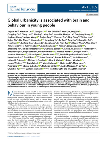
ARTICLESNATURE HUMAN BEHAVIOURa201. Tianjin2. Zhengzhou3. Nanjing4. Hefei5. Xuzhou6. Wenzhou7. Wuhan8. Yantai9. Taiyuan10. Xi'an11. 100100–500 N500–1,000 1,0003110150 300 km075 150 miles12. Shijiazhuang13. Lanzhou14. Changsha15. Jinan16. Dalian17. Hangzhou18. Haikou19. Shanghai20. Beijing21. Chengdu1. Nottingham2. London3. Dresden4. Berlin5. Mannheim6. Dublin614235N180None1–5050–100100–500250 500 km0 125 250 milesAnnual residential informationRecruitmentBirth1986S2. NDBIS1. NLbS3. NDWI.S4. NDVIS5. built-up%2017S6. cropland%2018S7. grassland%S8. forest%Multiple imputation and UrbanSat construction1YS1. NL.30YCorrelation with population densityS9. water body%Lifetime UrbanSat1Y1Y.S9. water SnSbaUrMigrationSusceptibility periods of lifetime UrbanSatBehavioursBrain and behaviourCognitionmental healthNDVIHigher correlation of UrbanSatwith population density from GHSLatLongitudinal brainBuilt-up%Cropland%Sensitivity analysisCumulitive effect of UrbanSat on brain and behavioursCross-sectional brainRho valueImpute10Impute10.Impute1Impute1Ten-fold cross validation ofimputation model building and CFA model optimizationSatellite datawith missing valueNLSubjects.Subjects.Subjects.S9. water body%1Y.30YSubjects.Subjects.S1. e Young adultCHIMGENIMAGEN FU2CHIMGENIMAGEN BL-FU2Meta analysisCHIMGENIMAGEN FU2CHIMGENFig. 1 Schematic summary of study design. a, Geographic distribution of recruitment sites and number of participants collected in each city ofChina and in each country of Europe (top), including five sites in Tianjin, two sites each in Zhengzhou, Nanjing, Hefei and Wenzhou and one sitein the remaining cities. Lifetime residential geopositions of each participant collected from 1986 to 2018 (bottom). On the basis of the individualgeoposition data, the annual values of nine satellite measures of urbanicity are obtained for each participant, including NL, NDBI, NDWI, NDVI and fivemeasures derived from land cover mapping (built-up%, cropland%, grassland%, forest% and water body%). b, Tenfold cross-validation of multipleimputation model building and CFA model optimization for UrbanSat construction. The optimized CFA model includes NL, built-up%, cropland% andNDVI. The mean UrbanSat scores before 18 years showed stronger correlation with ground-level population density from GHSL than any individualsatellite measures in both CHIMGEN and IMAGEN-FU2. c, Investigation of the cumulative relations of UrbanSat with brain and behaviour. d, Identificationof susceptibility periods of lifetime UrbanSat on brain and behaviour using distributed lag models. CFA, confirmatory factor analysis; GHSL, globalhuman settlement layers; IMAGEN BL-FU2, IMAGEN BL-FU2 measures brain structural and functional change rate between BL of 14 years andFU2 of 19 years; IMAGEN FU2, IMAGEN second-follow-up-assessment acquired at 19 years of age; NDBI, normalized difference built-up index; NDVI,normalized difference vegetation index; NDWI, normalized difference water index; NL, night-time light; S, satellite measures of urbanicity; Sub, subjects;Y, years old.NATuRE HuMAN BEHAVIOuR www.nature.com/nathumbehav
ARTICLESNATURE HUMAN arkMongoliaKyrgyzstanIrelandUKNorth ladeshIndiaVietnamLaosThailandbLMigration iaSerbiaSpainHNLGHSLMongoliaRomaniaBosniaand rease0No creaseDecrease0500KmIncrease0DecreaseIncreaseNo KmKmNorth eKm0.5**** **** ** **0NDVI****ClBuilt-up–1.0*NL–0.5UrbanSatRho valueGHSL POP2000NDVI** **Cl–1.0GHSL t-upClNL******* * **** ****NLRho value0.5–1.0GHSL POP20001.0UrbanSat–1.0GHSL POP1990UrbanSat–0.5********* ** * *** *0NDVI–0.5Built-up*Rho value*Cl–1.00.50NDVI****ClBuilt-up–0.5*0.5** ** *** * * ** *NL**d1.01.0RuralTownCityAll****0UrbanSatRho value0.5**UrbanSat****Rho value1.0NLcGHSL POP2015Fig. 2 Maps of satellite-based measures of urbanicity in China and Europe. a, UrbanSat maps of China (left) and Europe (right) in 2013. b, Maps showingtemporal changes of satellite measures of urbanicity during available years in China (top row) and Europe (bottom row). Left, migration patterns of 3,306participants in CHIMGEN and 561 participants in IMAGEN-FU2. Blue, green and orange dots represent geographic locations of participants in the year1990, 2000 and 2015, respectively. The box on the map represents the extent of zoom-in maps of each satellite measure of urbanicity in the right columns.Right, Changes of GHSL-population density between 1990 and 2015, NL between 1992 and 2013, built-up% and cropland% between 1992 and 2015 andNDVI between 1981 and 2017 in zoom-in part of China and Europe. Different time ranges are available for different satellite registrations. c,d, Correlationsof UrbanSat and individual satellite measures with population density in 3,306 CHIMGEN (c) and 561 IMAGEN-FU2 (d) participants. Columnsdemonstrate ρ value (y axis) of the UrbanSat and individual (NL, built-up%, cropland% and NDVI) satellite measures (x axis) with GHSL-populationdensity in rural (yellow), town (orange), city (red) and combined (dark red) in CHIMGEN for the years 1990, 2000 and 2015, and in IMAGEN for the years2000 and 2015. Cl, cropland%. *Significant correlations of satellite measures of urbanicity with population density using Spearman correlation analysis.in GHSL ground-level population density data, thus validating therelation of UrbanSat and GMV (Extended Data Fig. 5).In IMAGEN-FU2 (n 415), we replicated CHIMGEN findings. The uncorrected statistical correlation map of UrbanSat withbrain GMV in CHIMGEN showed significant spatial correlationwith that of IMAGEN-FU2 (r 0.40, P 0.001; Extended DataFig. 4). UrbanSat was correlated with GMVs of the mPFC (ρ 0.15,P 0.003) and cerebellum (ρ 0.13, P 0.009), and SA of the mPFC(ρ 0.19, P 0.001), but not CT of the mPFC (ρ 0.03, P 0.589)(Fig. 3b and Supplementary Table 12). In voxel-wise analyses, we validated the negative correlation of UrbanSat with mPFC volume andpositive correlation with cerebellar volume (Extended Data Fig. 4),both driven by NL and built-up% (Extended Data Fig. 5).To exclude possible scanner and site effects, we performedseparate analyses for each acquisition site of CHIMGEN andIMAGEN-FU2, carrying out a meta-analysis with an inverseNATuRE HuMAN BEHAVIOuR www.nature.com/nathumbehav
ARTICLESNATURE HUMAN BEHAVIOURaT score8–8LRb1010CHIMGENIMAGEN FU2T score–7mPFC–lg(P)IMAGEN BL-FU255T score8Cerebellum1–1mPFC GMV0.060.020.020–0.02mPFC CTLmPFC SA0R0.040–0.02Cerebellar GMV0.04Cerebellar GMV0.06mPFC CTcmPFC GMV0RmPFC �0.060510 15 20 25UrbanSat lag300510 15 20 25UrbanSat lagd600400e*Life-long city livingMove to city before 14 years0.4Move to city after 14 years0.2*0300.2**510 15 20UrbanSat Sat0–0.2–0.205101520Age of migrating to city2530mPFC GMV0.20.10.100–0.1–0.1–0.2–0.2–0.3mPFC CT0.30.2–0.220010 15 20UrbanSat lagmPFC SA25*30*–0.3Cerebellar GMVFig. 3 Correlations of urbanSat with brain structure. a, Uncorrected statistical maps in the voxel-wise multiple regression of mean UrbanSat before18 years with brain GMV under parametric testing in CHIMGEN (n 2,176). b, In CHIMGEN, UrbanSat is negatively (blue) correlated with mPFC-GMV(left) and positively correlated with cerebellar-GMV (right) (FWE Pc 0.05). The correlation of UrbanSat with mPFC-GMV is driven by SA rather thanCT, and these correlations are replicated in IMAGEN-FU2 (n 415); UrbanSat is correlated with brain volumetric change in mPFC (n 340) in IMAGENBL-FU2, which is driven by the change of SA rather than CT (n 325). Dashed red lines indicate the threshold of P 0.05. c, Susceptibility period analysisof brain structure using DLM. In CHIMGEN, we observed a negative association of UrbanSat with mPFC-GMV during childhood and adolescence (age 4–15years) and mPFC-SA during childhood (age 5–7 years) as well as a positive association with cerebellar-GMV during childhood (age 1–10 years). The y axisrepresents the changes of brain structural features associated with an increase of interquartile range of UrbanSat; the x axis is UrbanSat lag in years of ages.Grey areas indicate 95% CI. A susceptibility window is identified for the ages where the estimated 95% CI (shaded area) does not include zero. d, Numbersof participants migrating to city at different ages. Inset, UrbanSat is highest in participants with life-long city living (n 562), medium in participantsmoving to city before 14 years (n 229) and lowest in participants moving to city after 14 years (n 1,385). e, Participants who were born in the city ormigrated to an urban environment at an earlier age showed smaller mPFC-GMV and mPFC-SA as well as greater cerebellar-GMV than those with laterexposure. Error bars show mean and s.e.m. BL, IMAGEN baseline assessment acquired at 14 years old; BL-FU2, IMAGEN BL-FU2 measures brain structuralchanges rate between BL of 14 years and FU2 of 19 years; CT, cortical thickness; DLM, distributed lag model; FU2, IMAGEN second follow-up assessmentacquired at 19 years old; L, left; R, right; SA, surface area. *P 0.05.variance-weighted random-effects model (Methods andSupplementary Methods). UrbanSat remained significantly negatively correlated with mPFC-GMV and SA, and positively correlatedwith cerebellar-GMV (Extended Data Fig. 6 and SupplementaryTable 13). Heterogeneity of effect sizes was low to moderate forall regions (I2 range 0.05–60.21%; Supplementary Table 13). Thus,NATuRE HuMAN BEHAVIOuR www.nature.com/nathumbehavthe observed correlation between UrbanSat and brain structure isrobust across geographies and socio-cultural conditions.We applied distributed lag models (DLMs) to identify susceptibility periods of lifetime UrbanSat on GMV and SA (Methods).We observed a negative association of UrbanSat with mPFC-GMVfrom age 4 to 15 years (Fig. 3c) and SA from age 5 to 7 years
ARTICLES(Fig. 3c), indicating a susceptibility period during childhood and adolescence, driven by NL, built-up%, cropland% and NDVI (ExtendedData Fig. 7). Correlation of UrbanSat with cerebellar-GMV was significant from age 1 to 10 years, indicating a susceptibility periodduring childhood (Fig. 3c), driven by NL, built-up% and cropland%(Extended Data Fig. 7).To investigate the relation between UrbanSat and brain development, we used the longitudinal IMAGEN dataset to calculate volumetric (n 340) and SA/CT change rate per year (n 325) betweenbaseline (BL) at 14 and FU2 at 19 years (IMAGEN BL-FU2).Consistent with the susceptibility periods identified, UrbanSat wassignificantly correlated with brain volumetric development in themPFC-ROI (ρ 0.24, P 0.001) but not cerebellum-ROI (ρ 0.04,P 0.456). This correlation was driven by mPFC-SA changes(ρ 0.23, P 0.001), not by CT changes (ρ 0.002, P 0.967)(Supplementary Table 12).To measure the relation between age of migration and brainstructure, we split CHIMGEN participants into those who migratedto the city before age 14 years (n 229, mean age at migration8.24 4.86 years), after age 14 years (n 1,385, mean age at migration 17.17 2.68 years) and life-long city-dwellers (n 562) (Fig. 3d).We found that participants born in the city or early migrantsshowed smaller mPFC-GMV (P 0.032) and SA (P 0.001) as wellas greater cerebellar-GMV (P 0.001) than those with later exposure (Fig. 3e and Supplementary Table 14).No correlation of UrbanSat with white matter microstructure.Using tract-based spatial statistics (TBSS) analysis of diffusion tensor imaging (DTI) data, we did not find significant correlation ofUrbanSat with brain fractional anisotropy (FA) in either CHIMGENor IMAGEN-FU2 (TFCE-FWE, Pc 0.05).Correlations of UrbanSat with resting-state functional networkconnectivity. Using group-independent component analysis ofestimated 30 independent components (Supplementary Methods),we identified 17 resting-state networks (RSNs) related to cognitiveand sensory-motor processes13 in both CHIMGEN and IMAGEN(n 2,156) (Extended Data Fig. 8). For each RSN, we tested therelation between mean UrbanSat and within-network functionalconnectivity (WNFC). A voxel-wise multiple regression analysiscontrolling for all confounders revealed a negative correlation ofUrbanSat with WNFC in the mPFC of the anterior default modenetwork (aDMN) (peak MNI coordinate: x 3, y 69, z 0; 142voxels; peak t value 6.33), and positive correlations in the cerebellar vermis of the cerebellar network (CN) (peak MNI coordinate:x 15, y 63, z 15; 156 voxels; peak t value 7.09), in the leftlingual gyrus (LG) of the medial visual network (mVN) (peak MNIcoordinate: x 12, y 90, z 0; 114 voxels; peak t value 6.98)and in the left LG of the lateral visual network (lVN) (peak MNIcoordinate: x 24, y 81, z 13; 141 voxels; peak t value 6.97)(FWE Pc 0.05, additionally corrected for 17 RSNs; Methods)(Fig. 4a). Voxel-based correlations of individual satellite measureswith WNFCs of each RSN are shown in Extended Data Fig. 9. Thecorrelations of UrbanSat with WNFCs in CHIMGEN were replicated in ROI-based analyses in IMAGEN-FU2 (n 351) (aDMN:ρ 0.18, P 0.001; CN: ρ 0.26, P 0.001; mVN: ρ 0.24,P 0.001; lVN: ρ 0.24, P 0.001) (Fig. 4b and SupplementaryTable 12). Only the aDMN and CN results were replicated invoxel-wise analyses in IMAGEN-FU2 (Extended Data Fig. 9).Among 136 BNFCs, UrbanSat was correlated with 49 BNFCsin CHIMGEN (Pc 0.05, 10,000 permutations; Methods) (Fig. 4e),four of which were replicated in IMAGEN-FU2 (Fig. 4f). These fourBNFCs (aDMN-CN, aDMN-ECN, aDMN-rFPN and rFPN-lFPN)connect five brain functional networks (aDMN, CN, executive control network (ECN) and right or left frontoparietal network (r/lFPN)),implicated in self-referential thoughts14 and executive control15.NATURE HUMAN BEHAVIOURThe correlations of UrbanSat with WNFCs and BNFCswere stable in a meta-analysis of all CHIMGEN and IMAGENsites (Extended Data Fig. 6 and Supplementary Table 13). Brainlocalization (Fig. 4b,f) and susceptibility periods (Fig. 4d,h) ofWNFCs and BNFCs in CHIMGEN and IMAGEN were consistentwith those observed for brain structure (Extended Data Figs. 7 and9), except for non-significance during adolescence. The changesin WNFCs and BNFCs between 14 and 19 years in IMAGENwere correlated with UrbanSat (Fig. 4b,f, Supplementary Table 12and Supplementary Results). In CHIMGEN, WNFCs and BNFCswere correlated with age of migration to the city (Fig. 4c,g andSupplementary Results).Correlations of UrbanSat with behaviour. We investigated whetherUrbanSat is related to measures of cognition and mental health,that is, depression and anxiety. In CHIMGEN (n 2,148), thesocial cognition measure ‘perspective-taking’, perceiving a situationfrom an alternative point of view16, was positively correlated withUrbanSat (reaction time for perspective-taking: ρ 0.16, Pc 0.05,Bonferroni corrected for data categories and 21 behavioural assessments; Methods) and replicated in IMAGEN-FU2 (ρ 0.14,Pc 0.05) (Table 1, Extended Data Fig. 10 and Supplementary Table15). A negative correlation between UrbanSat and reaction time forperspective-taking performance was observed from 12 to 22 yearsin CHIMGEN (Fig. 5a).UrbanSat was correlated with depression symptoms assessedby Beck Depression Inventory (BDI) in CHIMGEN (n 2,170) (ρ 0.15, Pc 0.05) (Table 1) with a susceptibility period from 3 to 12years (Fig. 5a). As BDI was not available in IMAGEN, we validatedthis association using an instrument measuring core features ofdepression, the Ruminating Scale Questionnaire (RSQ) (ρ 0.14,Pc 0.05) (Table 1 and Supplementary Methods).In CHIMGEN and IMAGEN, increased NL and built-up% anddecreased NDVI and cropland% were significantly correlated withenhanced perspective-taking performance and increased depressionsymptoms (Table 1). The susceptibility periods for individual satellite measures were similar to UrbanSat in CHIMGEN (ExtendedData Fig. 7). Although most correlations of UrbanSat with brain andbehaviour were consistent between males and females, some correlations, especially with brain development
density is a well-established and quantifiable general measure of urbanicity that is frequently applied for neighbourhood classifica-tion and used around the globe9. Here, we aimed to use population density as a general measure of urbanicity to investigate whether the urban environment is correlated with brain and behaviour, and if