Transcription
FLORIDA AVENUE/NEW YORK AVENUE INTERSECTIONPUBLIC LIFE STUDYWASHINGTON DCJULY 2020DC Office of Planning1
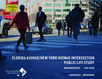
A NOTE ON COVID-19 AND RACIAL JUSTICEThe completion of this public life study coincided with the swift anddevastating arrival in Washington, DC, of the Coronavirus COVID-19global pandemic. Starting mid-March of 2020, most public life in theDistrict shut down almost immediately, with closed parks, shutteredbusinesses, and emptied streets.Site analysis and field work for this public life study was completedthe week prior to the March 11, 2020 State of Emergency in DC andsubsequent April 1 stay-at-home order. The study team feels that thedata and analysis represented herein is an accurate reflection of publiclife at the Florida Avenue, NE and New York Avenue, NE intersection area“pre-COVID”. The data analysis and recommendations in this reportwere completed prior to the racial justice protests sparked by themurder of George Floyd by Minneapolis police on May 25.While this report was being completed, the impacts of COVID-19 on thefuture of public space and public life were being debated around theworld. At the same time, and in the midst of this pandemic, millionswere marching in the streets and demonstrating in public spacesagainst racial injustice and police violence.This public life study does not directly address current or possiblefuture physical distancing requirements. Nevertheless, this study’srecommendations for improving people’s feelings of safety andcomfort at the FL/NY intersection align with identified strategies inaddressing the impacts of COVID-19, through ongoing public healthresponses and future recovery efforts. Central to that recovery is amore intentional understanding and operationalization of racialequity in the design and management of our shared public realm thatensures all people’s comfort, safety, and joy.An empty Florida and New York intersection on June 2, 2020
TABLE OF CONTENTSOVERVIEW 04EXECUTIVE SUMMARYPUBLIC LIFE ANALYSISFINDINGSRECOMMENDATIONSANALYSIS AND FINDINGSPHYSICAL AND SOCIAL CONDITIONS20HISTORY AND FUTUREWEEKDAY AND WEEKEND ACTIVITYBUILDINGS AND REDEVELOPMENT OPPORTUNITIESPUBLIC REALMFAÇADESSUN AND SHADOWTHERMAL COMFORTNOISEDEAFSPACE DESIGN PRINCIPLESFIELD WORK, DATA AND ANALYSISHOW ARE PEOPLE MOVING?WHAT ARE PEOPLE DOING?WHAT ARE PEOPLE SAYING?URBAN DESIGN RECOMMENDATIONSSTREETS AND STREETSCAPESSPACES AND BUILDINGSSUMMARY OF RECOMMENDATIONS58ACKNOWLEGEMENTS 73APPENDIX74
OVERVIEWEXECUTIVE SUMMARYPUBLIC LIFE ANALYSISFINDINGSRECOMMENDATIONS
EXECUTIVE SUMMARYAsk someone from DC about the intersection of FloridaAvenue and New York Avenue (a.k.a. Dave Thomas Circle)and they will probably tell you a story about a bad personalexperience they had there; on foot, on a bike, or in a car. Todaythe intersection is a busy, sometimes disorienting place, anda harsh environment for people. However, this intersectionis a major gateway into the Nation’s Capital, the boundary ofPierre L’Enfant’s historic Plan of the City of Washington, DC,the crossroads of vibrant urban neighborhoods, and a publicspace that thousands traverse every day. In recent years, it isa place that groups and individuals from across the city arecollaboratively striving to improve.This report details the findings and recommendationsof a public life study to answer the question: how canthis be a better place for people in the future?People cross New York Avenue during afternoon rush hourThe Florida/New York (FL/NY) Intersection Public Life Studywas undertaken to inform the design and engineeringof the future public spaces being created through thereconstruction of the Florida Avenue and New York Avenueintersection. Building on years of successive planning for thethriving NoMa neighborhood, this study applied a disciplined,data-driven analysis for exploring opportunities to improvethe human experience of moving through the intersection andspending time in its future public spaces.6Florida and New York Intersection Public Life StudyOver three days in March, 2020, fieldwork documentedthe behavior of nearly 5,000 people moving throughand staying in the intersection. The study alsoaccounts for the experiences and preferences of over650 people surveyed on site and online.
Transforming the FL/NY Intersection into a comfortableand even delightful place for people is a monumentalchallenge that will take several years of sustained effortfrom government and community leaders. As the adjacentneighborhoods and city as a whole are growing and changing,the District is planning for a more inclusive and sustainablefuture that fosters opportunities for a robust public life.The 5 findings and 11 recommendations presented inthis report can be used by:This report is organized into three sections:1. A high-level overview of the study, including itsfindings and recommendations.2. Analysis of the study area’s physical and socialconditions, based on extensive fieldwork andengagement.3. Detailed urban design recommendations forreimagining how the intersection can be a moreinviting place for people of all ages and abilities.» community stewards for programming publicspaces at the intersection;» property owners considering adjacentredevelopments; and» government agencies implementing futureneighborhood investments or reviewingdevelopment applications.This public life study’s recommendations can be appliedto achieve long-term changes at the FL/NY intersection, aswell as for interim pilot projents. Meanwhile, the snapshot ofpublic life captured on a typical week or weekend day offersbaseline data for evaluating how permanent or temporarypublic space interventions at the intersection affect publiclife in the future.The prominent “Peoples Building” at the FL/NY intersectionwill one day stand over a people’s place.DC Office of Planning7
WELCOME TO THE FLORIDA/NEW YORK INTERSECTIONThe intersection of Florida Avenue NE, 1st Street NE, O StreetNE and New York Avenue NE, is a critical junction in theDistrict of Columbia, prominently located at the edge of thehistoric L‘Enfant Plan for the city. The intersection is knownlocally as “Dave Thomas Circle,” in reference to the founderof the Wendy’s restaurant franchise located at the triangularcenter of the intersection, or sometimes the “Virtual Circle,”due to the traffic pattern implemented by District Departmentof Transportation (DDOT) in 2010. While DC is home toseveral circles and squares at key junctions that are wellused neighborhood public spaces, this complex series ofintersections and triangular public spaces is referred to as theFL/NY intersection in this report.Location of FL/NY intersection on L’Enfant Plan (orange circle)8Florida and New York Intersection Public Life StudyThe neighborhoods around the FL/NY intersection havebeen the subject of major planning efforts in recent years,starting with the 2006 NoMa Vision Plan and DevelopmentStrategy. As major growth ensued in the NoMa and Eckingtonneighborhoods, the poor urban design and strainedconnectivity at the FL/NY intersection precipitated additionalplanning led by the NoMa Business Improvement District(BID) and NoMa Parks Foundation. These efforts included theNoMa Gateway Transportation Study (2009), NoMa PublicRealm Design Plan (2012), and Urban Land Institute (ULI)report, Transforming the Virtual Circle to Reconnect theNeighborhoods (2019).Starting in 2013, DDOT began to study and redesign the FL/NYintersection as part of a larger project to improve multi-modalmobility along Florida Avenue NE (floridaveproject.com). Theforthcoming reconfiguration of the intersection will improvesafety and create over 25,000 square feet of new public openspace in the area as thousands of additional people cometo live and work here in the coming years. Meanwhile, theNoMa BID and NoMa Parks Foundation partnered with DCgovernment to assist with additional landscape architecturedesign for the public spaces created through the conceptualredesigned intersection. To inform these efforts, and buildingon existing plans, the DC Office of Planning (OP) led this FL/NYIntersection Public Life Study to better understand how peoplewant and need to use the streets, sidewalks, and other publicspaces in the area now and in the future.
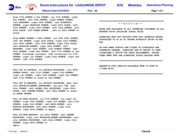
Flo ridFedExaAveNE Sirius XM PeoplesBuildingFedExSirius XMPeoplesBuildingNewkYorAversElevationFi tSt FloElevationridNewkYoraAveNEAve McDonald’s FL/NY Intersection, 2019McDonald’sUS Bureau of Alcohol, Tobacco,Firearms, and Explosives US Bureau of Alcohol, Tobacco,Firearms, and ExplosivesFL/NY Intersection redesign proposed by DDOT, May 2020Concept Sketch from ULI Report,June 2019DC Office of Planning9
WHY STUDY PUBLIC LIFE AT THE FL/NY INTERSECTION?OP uses public life studies to measure and understand thehuman experience of streets, plazas, and other public spaces.A public life study is a data-driven approach that appliesobservational, people-centric measures to inform policy,regulations, and public space design.Public life data can enhance the redesign of this prominentintersection and its public spaces as it transforms intoa more active and enjoyable place in NoMa. Findings andrecommendations from the public life study can inform publicspace designs, future building redevelopments, as well aspublic space programming and activation efforts.Learn more about OP’s public life program at planning.dc.gov10Florida and New York Intersection Public Life StudyAt the FL/NY intersection, it is expected that: Thousands more people will be living and working here incoming years. New buildings will replace parking lots, framing andactivating the intersection. The redesign will improve safety and create new publicopen spaces.To design a place for people, this public life study can help us: Improve the experience of the thousands of people movingthrough the intersection daily. Invite people to stop and stay in new public spaces. Support the intersection’s ongoing transformation into aneighborhood center and a prominent gateway.
FL/NY INTERSECTION AND THE SURROUNDING PUBLIC REALMSeveral new and improved public spaces are being builtaround the FL/NY intersection by the city, NoMa ParksFoundation, and private developers. These include:The Metropolitan Branch Trail (MBT) that crosses overFlorida Avenue, with a future “trail connection lobby”incorporated into the south tower of the WashingtonGateway project, currently under construction.The NoMa Meander, envisioned in the NoMa Vision Plan,to enhance neighborhood livability by breaking up the“superblocks” between North Capitol and First NE witha fun, inviting, four-block-long retail and pedestrianpromenade with green spaces, seating, water elements,and active retail edges along the adjacent developments.The first segment was completed in 2019.Metropolitan Branch TrailNoMa Meander MapAlethia Tanner Park, a 2.5-acre park, acquired by theNoMa Parks Foundation and completed in 2020. Thepark is connected to the MBT and two blocks from theFL/NY intersection, providing for outdoor recreation andcommunity gatherings and serve as NoMa’s “backyard.”Learn more about the NoMa Parks Foundation’s work atnomaparks.org.Alethia Tanner ParkDC Office of Planning11
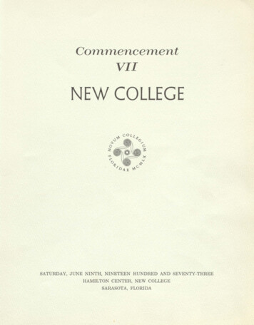
PUBLIC LIFE ANALYSISMETHODSThe DC Office of Planning led this public life study withtechnical assistance provided through the Transportation LandUse Connections program from the Transportation PlanningBoard (TPB). SmithGroup and Nspiregreen were the consultantteam assisting on the project.Seventeen volunteers were trained in the techniques of publiclife analysis, and assisted with fieldwork on site in early March,2020. SmithGroup and Nspiregreen compiled and analyzed thepublic life data collected and developed this report.The study applied site analysis and fieldwork techniquesdeveloped by the Gehl Institute and adapted by OP, consistingof:Rhythm ofDaytime ActivityLand UseCharacteristicsPublic RealmAssessmentCounting PeopleMovingEnvironmentalConditionsMapping PeopleStayingFaçadeAssessment12Study fieldworker interviewing pedestriansSTUDY AREAThe area of focus for the Public Life Study are shown in theimage on the next page:Surveying People’sPreferencesFlorida and New York Intersection Public Life Study Florida Avenue NE, from P Street NE to the Florida AvenueUnderpass Eckington Place, up to one block north of Florida Avenue New York Avenue from half a block west of 1st Street NE tothe New York Avenue Bridge 1st Street NE, between Florida Avenue and N Street NE2ndStreet NE, between Florida Avenue and N Street NE
FedExSirius XMPeoplesBuilding ElevationMcD’s US Bureau of Alcohol,Tobacco, Firearms,and ExplosivesDC Office of Planning13
FINDINGSThe intersection is despised.People surveyed during field work and online described the FL/NYintersection as a terrible place. People walking, biking, and drivingexperience the FL/NY intersection as frustrating and dangerous,and many try to avoid travelling through it. A confusing vehiculartravel pattern, absence of protected bikeways, and long wait timesat pedestrian signals contribute to unpredictable, impatient, andsometimes dangerous behavior.Survey respondents’ descriptions of the intersectionThe intersection is a harsh environment for people.The FL/NY intersection is wide, windswept, and lacks shelter for peoplefrom direct sun and heat in the summer and cold temperatures andwind gusts in the winter. There is very little green space with few treesand vegetation. There is a lot of asphalt and hard surfaces. Traffic noisereaches harmful and dangerous levels.Heat islands are created from large swaths of asphalt.Spaces and building edges do not contribute to asense of place.The FL/NY intersection is well maintained by the NoMa clean team witha consistent local and federal police presence. The built environment isnot an inviting place to be. Poor lighting at night, no pedestrian-orientedbusinesses active after business hours, substantial vehicle traffic, anda consistent security presence further diminish a sense of place orpersonal safety.14Florida and New York Intersection Public Life StudyBlank walls contribute to an unwelcoming space.
There are almost no opportunities for interaction.While many people live, work, or go to school in the area, theintersection does not provide opportunities for social interaction. Thereare almost no places to sit and few people were observed spendingtime together in spaces in and around the intersection. The onlyeating establishments are auto-oriented restaurants with busy drivethrus and a street vendor selling beverages, mainly to drivers waitingat traffic signals. Waiting at crosswalks with long periods betweenpedestrian signals offer the main opportunity for social interaction.One of the only places to sit outdoors around the intersectionYet the intersection is busy!Thousands of people move through the FL/NY intersection daily,especially during weekday mornings, after school, and late afternoons.The majority of people observed are of typical working age (between20 and 60 years old ) but there are also several high-school studentsin larger groups, couples, and parents with younger children. Onan average weekday, an estimated 3,800 people cross the FL/NYintersection between 8am and 7pm. The composition of this largenumber of people is perceived as proportionately more male thanfemale, both in terms of people moving and staying.School dismissal sends many students through theintersection on their way to Metro.DC Office of Planning15
RECOMMENDATIONSMake Walking asComfortable and Enjoyableas Possible.Create Safe and ComfortableRoutes for People on Bikesand Scooters.Integrate Public SeatingEverywhere.Intentionally design the intersection tobe safely enjoyed by people walking.Make cycling and scooting enjoyablefor people of all ages and abilities todiscourage riding on sidewalks andconflicting with pedestrians.Add comfortable public seating onsidewalks wherever possible and in allpublic spaces.Wide, well lit, tree-lined sidewalks serve all users.STREETS AND STREETSCAPES16Florida and New York Intersection Public Life StudyVertical barriers provide protection for cyclists fromcars.Seating can help channel pedestrian flows andprotect landscaping.
Create Better Bus Stops.Create Adaptable andConnected Spaces.Provide Protection alongFlorida and New YorkAvenues.Dignify transit users with places towait comfortably for buses.Design and program public spaces assmaller, intimate areas that contributeto a larger, integrated network,balancing the historic urban designwith neighborhood growth and change.Improve safety by integratingprotective elements along these busyand congested streets.Bus shelters with public art can connect people toplace.Open areas allow spaces to be used for a variety ofactivities.A decorative, vegetated median can deter jaywalking.SPACES AND BUILDINGSDC Office of Planning17
RECOMMENDATIONSCreate Comfortable Placesfor People.Create Welcoming andInviting Spaces for AllPeople.Enliven and Activate PublicSpaces.Integrate landscape and buildingelements that shelter from sun, heat,cold, wind, and noise.Create streetscapes and public spacesthat welcome and celebrate all people.Create opportunities for interactionand community with design elements,activities, and programming.Structures and vegetation can provide shade andcooling during hot weather.Barrier-free spaces can welcome and include peopleof all ages, gender identities, incomes, abilities, andbackgrounds.Farmers’ markets enliven public spaces on weekends.SPACES AND BUILDINGS18Florida and New York Intersection Public Life Study
Integrate Vegetation forHealth and Sustainability.Activate Edges around the Intersection.Create opportunities for personalwellness and a healthy environment.Design and program the edges of theintersection for more activity, transparency,permeability, and visual interest.Sensory gardens provide rest and connection tonature.Modulated building facades and balconies activate the edges ofsidewalks and other public spaces.Active uses and building entrances enlivensidewalks and public spaces.DC Office of Planning19
ANALYSIS AND FINDINGSPHYSICAL AND SOCIAL CONDITIONSHISTORY AND FUTUREWEEKDAY AND WEEKEND ACTIVITYBUILDINGS AND REDEVELOPMENT OPPORTUNITIESPUBLIC REALMFAÇADESSUN AND SHADOWTHERMAL COMFORTNOISEDEAFSPACE DESIGN PRINCIPLESFIELD WORK, DATA AND ANALYSIS
HISTORY AND FUTURENOMA HISTORY (Source: NoMa BID)The Florida and New York Avenue Intersection Public Life Study area lieswithin a neighborhood in DC known as NoMa (North of MassachusettsAvenue). Originally inhabited by Piscataway Indians, the area began todevelop in 1792, when Florida Avenue (then known as Boundary Street) wasestablished as the rural boundary of Washington, D.C. By the mid-1800s,NoMa was primarily farmland. The immigrant residents named the area“Swampoodle” for the swampy land and puddles created from overflowsof the Tiber Creek, a now-buried waterway that runs roughly along NorthCapitol Street. Swampoodle was largely characterized by brick rowhomessimilar to those seen in historic residential areas of Washington, D.C.In 1856, President Abraham Lincoln established Gallaudet University tothe northeast of Swampoodle, at the nearby intersection of Florida AvenueNE and 6th Street NE. In 1860, the Government Publishing Office wasestablished by an Act of Congress at the corner of North Capitol Street andH Street NW.in 2002. Subsequently, other public and private organizations beganleasing large blocks of office space close to Union Station, including CNN,CareFirst, the Federal Energy Regulatory Commission, U.S. Department ofEducation, and various agencies of the District of Columbia government.After the NoMa-Gallaudet U Metro station opened in 2004, NoMa becamethe fastest-growing neighborhood in Washington, D.C. The NoMa BIDwas formed in 2007 to support the revitalization of the neighborhood. Atthe end of 2018, NoMa had more than 13.2 million square feet of officespace and over 4,800 new apartments. More than 54,000 people work inNoMa each day, and more than 44,000 people live in the greater NoManeighborhood.FloWith the building of Union Station in the first decade of the 20th century,over 100 homes were condemned to make way for track and terminalconstruction, displacing and physically dividing Swampoodle residents.Once this rail hub was established, the area north of the station and westof the tracks became heavily industrial, with warehouses and coal yards.As rail transportation declined, the area experienced disinvestment anddeterioration. In the early 2000’s, the NoMa area, blocks from the U.S.Capitol and with excellent transit access, consisted mostly of vacant lots.In the last two decades, however, a renaissance has begun in NoMa. In2000, the newly created XM Satellite Radio established its studio andheadquarters in a renovated century-old printing warehouse near theintersection of Florida and New York Avenues. At the opposite side of theintersection, the US Bureau of Alcohol, Tobacco, Firearms, and Explosives(ATF) constructed their modern headquarters designed by Moshe Safdie22Florida and New York Intersection Public Life StudySITEridNewaAveSiriusXMATFEverk AkYorNewFedExMFloYoN Capitol StULineArenaUS Gov.PublishingOfficeUnionStationSite Context MapridAveaAveGallaudetUniversity
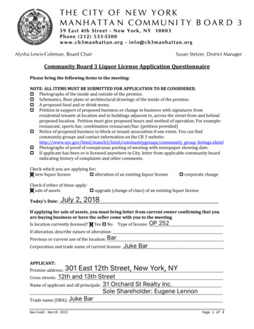
NOMA FUTURE(Source: NoMa BID)If the current pace of development continues, NoMa will be mostly builtout by 2024. At that time, it will likely include more than 8,000 residentialunits, roughly 22 million square feet of office space, a number ofsignificant retail/mixed-use projects, and several hotels.More than 100,000 cars pass through the study area daily and, accordingto the New York Avenue Corridor Study (2006), the intersection of NewYork/Florida Avenues and First Street NE has been ranked as the 7th mostdangerous intersection in DC (2001 Crash Data). Between 2002 and 2004,there were 144 crashes at the New York/Florida Avenues Intersection, andanother 80 crashes at 1st Street NE and New York Avenue (DDOT/PSI TrafficSafety Improvement Study).SITEDDOT’s ongoing Florida Avenue/New York Avenue Intersection projectwill reconfigure the existing intersection and address safety issues –particularly those involving pedestrian and bicycle safety concerns. Flo rid aAveNE FedExSirius XMPeoplesBuilding6 lanes acrossnew public spacesNewvekAYor 7 lanesacrossFirstSt FloElevation rid9 lanes across NewkYorAveaAveNEnew bike lanes McDonald’s US Bureau of Alcohol, Tobacco,Firearms, and ExplosivesFuture Study Area with Street Redesign Planned by DDOTNoMa Development Plan(Source: NoMa BID)DC Office of Planning23
WEEKDAY AND WEEKEND ACTIVITYThe intersection of Florida Avenue and New York Avenue NW is primarilyused as a place to travel through, rather than spend time in. Most peopletraveling through are on their way to employment, educational, orresidential destinations that surround or are beyond the intersection itself,and/or to and from the NoMa/Gallaudet Metro Station. Annual AverageDaily Traffic along New York Avenue is 46,700 vehicles, and according tothe NoMa BID, about 100,000 vehicles travel through the larger intersectionand area.Employment destinations include Federal and District government officesat the ATF and Peoples Building, respectively, as well as Sirius XM andFedEx to the north, and District Government and private offices to thesouth in NoMa. Educational destinations beyond the intersection includeMcKinley Tech High School and Langley Elementary School to the north,Friendship Public Charter School (PCS) to the west, and Two Rivers PCS tothe east. There is an established residential population in the Eckingtonneighborhood to the north and growing residential populations in UnionMarket to the east and the rest of NoMA to the west and south.The NoMa/Gallaudet Metro station has an equal number of weekday ridersentering and exiting throughout the day, with 8 am being the busiest hour,followed by 5 pm. Weekend ridership drops significantly. The intersectionarea has low patronage at the few restaurants and shops around theintersection. There is much less weekend activity and fewer pedestrians inthis area, many of whom run errands, walk pets, or exercise.18:25 amWeek day commuters cross New YorkAvenue.21:10 pmGrocery shopping after lunch onSaturday.33:26 pmSchool dismissal disperses studentsinto this area during the week. They headto transit and linger in groups aroundthe area.44:26 pmCongested traffic at Florida Ave. NE andFirst St. NE during afternoon rush hour.24Florida and New York Intersection Public Life Study
4231Existing Land Use PlanDC Office of Planning25
BUILDINGS AND REDEVELOPMENT OPPORTUNITIES21Bureau of Alcohol, Tobacco,Firearms, and ExplosivesPeoples BuildingGovernment/Civic3Government/Civic4Sirius XMFedEx (could be redeveloped)OfficeOffice65McDonald’s (could beredeveloped)Courtyard MarriottHotelRetail78Elevation with Retail on theGround FloorMulti-family Residential26Florida and New York Intersection Public Life StudyConstruction Site East ofElevationMulti-family Residential
32415786Existing Land Use Plan With Future Intersection Configuration and Potential Future DevelopmentDC Office of Planning27
PUBLIC REALMFlorida Avenue and New York Avenue are two of Washington DC’s iconicand ceremonial ‘state streets.’ Many state streets are wider and carryhigher volumes of traffic, typified by prominent buildings, mature treecanopies, while serving as commercial main streets in neighborhoods.Yet, the sidewalks where Florida and New York avenues intersect do nothave landscaped buffers from traffic and mostly lack pedestrian-scaledamenities like public seating and bike racks.There are currently no continuous east-west bike lanes through thisarea. Many cyclists and scooter riders also use the sidewalks, creatingunnecessary conflicts. Some areas have very narrow sidewalks, formingpinch points during rush hours. In addition, wide crosswalks and heavytraffic volumes can make navigating the intersection on foot or on bike achallenge.Many buildings are fronted by surface parking areas with fences,unfriendly to pedestrians and discouraging people to stay. The only truepublic seating is located to the north of the ATF building facing New YorkAvenue, but this area is technically private property and can be perceivedas uninviting due to the security presence.The open expanses of surface parking, large billboards, and higher speednature of New York Avenue contribute to a highway-like experience.1282Narrow SidewalksNarrow sidewalks form sidewalkpinch points during busy times.3Public seating areaPublic seatings to the north of theATF building feel uninviting due tothe security presence.4Peoples Building CourtyardThe space between the PeoplesBuilding and garage has been turnedinto a courtyard space with seating.5Cyclists on sidewalksVacant Land & Parking LotCyclists rides on the sidewalks dueto lack of bicycle lanes.Vacant parcels and surface parkinglots dominate this area.Florida and New York Intersection Public Life Study
24153Existing Public RealmDC Office of Planning29
FAÇADESEngaging façades lining public spaces are an important contributor tosuccessful public life. Façades are more engaging when they are designedat the human scale and encourage more social interaction and sensorydelight. At the ground floor, engaging façades vary in color and texture,include inviting signage, have integrated plantings, are articulated witha higher frequency of functioning entrances and windows, and are moretransparent.In the study area, retail storefronts on N St. and 2nd St. NE have the mosttransparent façades and the highest density of active doorways. TheElevation building also has some transparency along Florida Ave, withsome outdoor dining areas active in good weather.The Sirius XM building has brick walls with little active doors on theground floor. Large footprint buildings such as the ATF buliding and theFedEx Building not only have little or no transparency on the façades, butalso have fences around their properties.30Low TransparencyThe Sirius Building along EckingtonPl has brick walls with some windowsand entries. The addition of a modernentry adds interest to the traditionalbrick façade.Low TransparencySolid walls with some windows. Theground floor has only a few activedoors, but the bright murals make thefaçade more interesting.High TransparencyNo TransparencyRetail storefronts along N St NE and2nd St NE have good views of activitywith multiple active doors. Signageand bright interior colors contribute tomaking these façades engaging.Although the structure of the ATFBuilding suggests transparency, thereare few views in or out at street leveldue to columns and fences.Moderate TransparencyNo TransparencyThe Peoples Building has somewindows on its façade with someactive doors at the ground level.Reflective glass makes transparencyonly one way on this building.The Sirius FM Building façade alongFlorida Ave NE has solid brick walls.Concrete reinforcements to thecolumns narrow the sidewalk andcreate pinch points.Florida and New York Intersection Public Life Study
Existing façade TransparencyDC Office of Planning31
SUN AND SHADOWPeople are attracted to sun and shade at different times of day andyear. Opportunities for both can help to make a place more inviting andenjoyable. 3D models were created to study sun and shadow conditionsat the intersection at 9am, noon, and 3pm at the Spring Equinox, SummerSolstice, Fall Equinox, and Winter Solstice. On the following pages, themodels show how shadows fall throughout the day and year from both theexisting buildings and public space design, and from future buildings onthe proposed public space design.The central triangle where Wendy’s is located is not in the shade of anybuilding all year round. In a fully built future scenario, it will still be fullyexposed to the sun mid-Summer and enjoy morning and midday sun midWi
10 Florida and New York Intersection Public Life Study. OP uses public life studies to measure and understand the . human experience of streets, plazas, and other public spaces. A public life study is a data-driven approach that applies observational, people-centric measures to inform policy, regulations, and public space design.