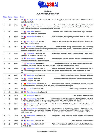
Transcription
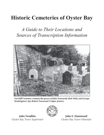
Historic Cemeteries of Oyster BayA Guide to Their Locations andSources of Transcription InformationPhoto courtesy of the Oyster Bay Historical SocietyFort Hill Cemetery contains the graves of John Townsend, died 1668, and GeorgeWashington's Spy Robert Townsend (Culper Junior).John VendittoOyster Bay Town SupervisorJohn E. HammondOyster Bay Town Historian
A Message FromTown SupervisorJOHN VENDITTOJOHN VENDITTOTown SupervisorDear Genealogy Enthusiast,In recent years, genealogy has become one of the world's most popular hobbies.Countless people around the world are actively engaged in some form of familyresearch. Whether it's to satisfy a curiosity about oneself, provide children with asense of who their ancestors were or to compile a medical history, people aretrying to get in touch with their roots.Cemeteries are an important research tool for many people delving into genealogy. Inscriptions on gravestones can be a significant source of genealogical information, but locating cemeteries, especially older ones, is not always easy. Thisbooklet was developed to help those engaged in genealogical research in locating the old cemeteries. It lists historical cemeteries in the Town of Oyster Bay,along with the transcription records for those cemeteries.Careless hobbyists, vandalism and deterioration with age have taken a heavy tollon these historic cemeteries. If you do visit a cemetery, please be quiet and respectful while in the cemetery and try not to walk on graves.I hope you find this booklet interesting and helpful as you "climb" your family tree.Very truly yours,JOHN VENDITTOTown Supervisor
Historic Cemeteries of Oyster BayA Guide to their Locations and Sources of Transcription InformationResearched and compiled by John E. Hammond, Town HistorianFirst Printing February 2007IntroductionFor the historian and genealogist, cemeteries are vast repositories of information about the past.Within the pre-1920 boundaries of the Town of Oyster Bay are located some of the very oldest cemeteriesto be found anywhere in New York State. The earliest cemeteries were small family plots such as theTownsend or Mill Hill cemetery located just to the west of the Mill Pond in Oyster Bay. This was a familyburial plot for Henry Townsend, who built the first mill in Oyster Bay in 1661 and was buried on his ownproperty. In nearby Oyster Bay Cove, the Youngs family set aside a plot of their own land for a familyburying place in 1658. Today, this family burying plot also contains the grave of Theodore Roosevelt, 26thPresident of the United States. Various church groups began cemeteries in the later part of the 17th century,the earliest being the Friends, who set aside a cemetery on the west side of South Street in Oyster Bay in1672.Interest in the documentation of the early burials within the Town goes back to the 1800s whensome historians and family researchers began recording the inscriptions on the stones in some of the veryoldest cemeteries. Samuel Youngs wrote about the difficulty finding the gravestones of the earliest settlersof Oyster Bay and many had disappeared even by the early 1800s; whether Samuel Youngs made anytranscriptions is unknown. He, no doubt, was feeling some frustration even then as revealed in a short versehe wrote in the early 1800s;“Where are the stones that mark the bonesOf those who die in Oyster Bay?There are no stones to mark the bonesOf those who die in Oyster Bay.”The earliest surviving records of cemetery transcriptions is entitled “Oldest Inscriptions in BurialGrounds in this Vicinity” by Jacob T. Bowne. Bowne’s 1867 record covered a few cemeteries in the GlenCove area. These efforts were followed by many researchers in the latter part of the 19th century. Mostnotable of these later researchers was Josephine Frost, who compiled information previously gathered byWilliam Wyckoff on cemeteries throughout Long Island.Over the years, many headstones have disappeared from the old cemeteries; some were used inbuilding foundations, as door stoops, and for walkways. During the Revolutionary War, Hessian andBritish soldiers reportedly desecrated many local graves and took headstones to use for various purposes.Many family cemeteries simply disappeared, while some were removed to larger public cemeteries. Manyremaining gravestones have deteriorated so much that they are now completely unreadable. Unfortunately,in many cases, the transcription records made by those early historians and family researchers are now allthat remain.
Purpose of This GuideThe purpose of this guide to Historic Cemeteries of Oyster Bay is to be of assistance togenealogical and historical researchers in determining the locations of the historic cemeteries within thepre-1920 boundaries of the Town of Oyster Bay and to serve as a guide to where transcription records canbe found. The guide includes all known cemeteries that have ever existed within the Town of Oyster Bay.Although 23 of the cemeteries listed in this guide no longer exist, several individuals in the distant and notso distant past had the foresight to record the information that was then still present. Some records exist asthe direct result of WPA projects during the 1930s. As one peruses the various sets of transcriptionsbeginning in the nineteenth century and up through those completed in the 1960s by Town of Oyster BayHistorian Herbert Hale, the ravages of time on the old stone inscriptions become clearly evident.This guide does not suggest, nor does it encourage, visits for information gathering purposes toany of the historic cemeteries listed within it. Whatever information remains on the surviving stones isclearly much less than what was transcribed years ago and the sources for obtaining those transcriptionrecords are included within this guide.Usage of this guideThe cemeteries listed within this guide are arranged first by present day locality and thenalphabetically by the most commonly known name of the cemetery; also included is a listing of all knownnames of the cemeteries. The names and descriptions of the locations were taken from the old transcriptionrecords; in some cases, the points of reference no longer exist. At least one transcription record is listed foreach named cemetery and, in many cases, there are multiple records. Some of the cemeteries contained inthis guide are still active; researchers seeking information relative to active cemeteries should be able tofind inscription information by contacting those cemeteries.Bayville(1)Bayville Cemetery Inc.Bayville AvenueEarliest stone dated 1812, most date from 1830s and later.Active-Records at Bayville Village Hall.Partial Inscriptions-Frost 1912; DAR 1941.(2)Native American GraveEnd of East Slope Road and Washington Avenue.One burial dated by radiocarbon test to 1550 A.D.Data-Bayville Village Historian, TOB 1961.Bethpage(3)Stymus Family CemeteryNorcross Ave and south side of Revere Avenue.Inscriptions-Meigs 1938.
(3A)Powell CemeteryCemetery is located on the old Grumman plant property about a quarter mile west of theBethpage Community Park. Letter in June 1953 Long Island Forum says cemetery waslocated "alongside of the Grumman Air Plane Plant.” Gersham Saxton was reported by adescendant to be buried there. Contains more than 20 Powell family graves. One stonehas a carved finger pointing skyward with the words “going home”.Inscriptions-Meigs 1938, page 104A.Brookville(4)African-American CemeterySouthwest side of Brookville Road approx. 2,500 ft NW of Rte 106.Inscriptions-TOB 1961, only one readable stone (Henry T. R. died 1886).(5)Dodge Family CemeterySouthwest side of Brookville Road approx. 1,000 ft northwest of Rte 106.Dodge, Baker, Wiggins, Brown families. Earliest stones 1807.Inscriptions-TOB Nov. 19, 1961.(6)Tappentown Cemetery AKA Nostrand-Waldron Cemetery400 feet south of Cedar Swamp Road, 400 feet east of Cowpath and 500 feet west ofFruitledge Road.Cemetery dates to 1777. Oldest readable stone in 1968 was dated 1806, last known burial1873. Tappen, Davis, Waldron, Nostrand, Thorne families. Three Tappen family gravesremoved to Brookville Cemetery before 1903.Inscriptions-TOB 1963 with supplements from Stoutenburgh’s Documentary History ofthe Dutch Congregation at Oyster Bay.(7)Titus Burial GroundBetween Rolling Drive and Wheatley Road on grounds of Robin Hood Country DaySchool.Titus, Hinman, Crooker families, earliest stone 1805.Inscriptions-DAR June 1950; TOB December 3, 1961 supplemented with informationfrom family descendants; TOB 1969 site map of 26 graves.Centre Island(8)Ludlam CemeteryOff Centre Island Road19 stones from early 1700s.Inscriptions-DAR 1941; TOB October 27, 1961.(9)Smith CemeteryOff Centre Island Road.Contains grave of Daniel Smith, veteran of War of 1812.Inscriptions-DAR 1941; TOB 36 stones copied October 27, 1961.Cove Neck(10)Smith Family CemeteryNorth end of Cove Neck Road where road makes sharp right turn.Approx. 19 stones from 1855 through 1953.Inscriptions Frost 1912; DAR 1941; TOB Nov. 16, 1961.
East Hills/Old Brookville(11)Townsend Cemetery100 yards south of Rte 25A about one mile west of Whitney Lane. Cemetery straddles theline that separates the Town of Oyster Bay and the Town of North Hempstead.Earliest stone Timothy Townsend died 1790; other families include Horsfield andJackson. Property was under development when 1961 survey was done and surveyorstook special care to record all data as they believed the site would soon be destroyed.Inscriptions-Frost 1912; TOB 1961 (in very poor condition in 1961 when fragments werecopied).East Norwich (Also see Muttontown)(12)Elbert Hegeman CemeteryRear of north end of shopping center, east side of Rte 106.Cemetery named after Major Elbert Hegeman 3rd N.Y. Prov. Cavalry, Civil War who isburied here. Rutgers Hegeman 84th Reg. NY Vol. Civil War also buried here.Inscriptions-DAR 1941; TOB November 3, 1961.(12A)Franklin/Wright Family CemeteryWas formerly located on the east side of Mill River Road, about 900 feet south ofNorthern Boulevard. Family remains were reburied at Brookville Cemetery in the “OldSection”, lot 96.(13)Oak Hill CemeteryFormerly located on north side of Sugar Tom’s Lane. Stones removed to St. John’sEpiscopal Church Cemetery (From TOB notes 1961).Farmingdale(14)Bethpage CemeteryQuaker Meeting House Road near Merritt Road, south side of road westerly of threeadjacent cemeteries. Eardeley copied inscriptions on 15 June 1898 and stated there were246 stones plus a significant number of graves without stones. His transcriptions appearto have combined this cemetery along with the Friends Burial Ground (16) and thePowell Family Cemetery (17) into one record.Inscriptions-Eardeley, Wm. A., 1918; Queensborough Public Library.Although the Bethpage Cemetery Association is inactive, burials continue because offamily ownership of burial plots.(15)Cornelius CemeteryNorth side of Fulton Street between Cobb Pl and Doud Street.Inscriptions-Eardeley, Wm. A., 1918; Queensborough Public Library. Eardeley describedthe cemetery as being “in wretched condition” in 1894. There were 19 stones in 1894with burials dating from 1839.Cemetery Inactive-maintained by Village of Farmingdale.(16)Friends Burial GroundQuaker Meeting House Road; south side of road by meeting house. Meeting house wasbuilt 1743 according to Nassau County Historian Jesse Merritt (see Long Island ForumDecember 1956, page 231). Cemetery dates to early 1700s.Burials in this guide were extracted from Encyclopedia of American Quaker Genealogy.Active. Also see Eardeley transcriptions. Records kept by Clerk of Bethpage FriendsMeeting.
(17)Powell Family CemeterySouthwest corner Quaker Meeting House Road and Thomas Powell Blvd.Inscriptions-Meigs 1938 Also see Eardeley transcriptions.Active. Powell Cemetery Corp.(18)Van Cott CemeteryNortheast corner Grant Avenue and Rose Street.Burials date from 1819.Inscriptions-Eardeley, Wm. A., 1918; Queensborough Public Library.Inactive. maintained by Village of Farmingdale.Glen Cove(19)Albertson Family CemeteryTown Path. 3 stones all Wrights, 1827-1855.Inscriptions-Frost 1912; TOB 1961.(20)Coles Family CemeteryFormerly located in the parking lot of Columbia Ribbon and Carbon Company. Thegranite stone marking the death on April 16, 1715 of Robert Coles was removed toprivate property in 1954 by Robert R. Coles, bulldozers then leveled the propertydestroying the remaining graves (Long Island Forum, page 166, September 1954).Inscriptions-Frost 1912.(20A)Coles CemeteryHighland Road, adjoining St. Paul’s Episcopal Church Cemetery.Inscriptions-Frost 1912.(21)Craft CemeterySouth of Craft Heights near Cecil Avenue.William H. Carpenter, 2nd NY Inf Civil War, died July 27, 1913 was interred here.Inscriptions-DAR 1941 10 stones; TOB April 11, 1954 only 7 stones remained.(22)Dickson CemeteryPearsall Avenue and LIRR tracks.On August 12, 1955 P. L. Van Santvoord interviewed former Glen Cove Mayor Dr.James Burns about this cemetery. Dr. Burns related that as a boy he recalled mounds butno stones. During construction of the Arterial Highway efforts were made to locate theold graves which were believed to be 200-300 years old and contained the graves of someof the original settlers of Glen Cove. The search and digging only revealed what wasbelieved to be a layer of fine bone dust which was placed in a box and interred in theDickson family plot of St. Paul’s Church Cemetery.(23)St. Paul’s Episcopal Church CemeteryHighland RoadHall family inscriptions copied 1950 DAR. Cemetery was consecrated in 1834 but theoldest stone is dated 1801 (From TOB notes 1961). Charles A. Dana, editor of the NewYork Sun is buried here (Long Island Forum, March 1960). Active.(23A)Hyde Family CemeteryHighland Road, adjoining St. Paul’s Episcopal Church Cemetery.Inscriptions-Frost 1912.(24)Garvie CemeteryGarvie’s Point RoadSome stones lost due to housing development, remaining inscriptions copied 1955 TOB.
(25)Landing CemeterySouth of McLaughlin Street and east of Landing School.Obliterated by Dickson Gardens Development (1953)12 remaining stone inscriptions copied 1953 TOB.(26)Miller CemeteryFormerly located behind No. 12 Hillside Avenue. 11 graves re-interred at unknownlocation to make way for urban renewal project in 1961. One of these graves was of JohnE. Miller who died a prisoner at Andersonville, Ga. during Civil War.Inscriptions-TOB 1961.(27)Townsend Cemetery AKA Duck Pond CemeteryOn the grounds of Nassau Country Club. The earliest burial was of William Townsendwho died in 1777 on his Duck Pond Farm. Townsend, Cock, Valentine, Covert, others.Inscriptions-Frost 1912; TOB November 1, 1961.(28)Weeks CemeteryFormerly was located west of Red Spring Lane. No trace of actual site remains.Three graves were removed to St. Paul’s Churchyard between 1833 to 1836 (From TOBnotes 1961).(29)Woolsey CemeteryNorth end of Dosoris Lane. According to Peter L. Van Santvoord the cemetery wasmoved from its original location. (see Long Island Forum March 1957, page 51).Josephine Frost, on page 36 of her Frost Genealogy, describes its location in 1912 as“Locust Grove, Dosoris, L.I.” Cemetery contains graves of three veterans of ColonialWars including Melancthon Taylor Woolsey who died in 1758 while battling the French,also Lt. Col. Charles W. Woolsey veteran of Civil War. Still in use in 1950s.Woolsey family inscriptions copied by DAR 1941. Colonial stones inscriptions copied1955 TOB (Pages 4 and 16-18, 85).(30)Wright CemeteryVicinity of Summit Place.Contained burials of relatives of Joshua Wright. Destroyed in July 1930 duringconstruction of Brewster Street (Glen Cove Echo-July 1930). Plowed under many yearsago (TOB notes 1961).(31)Calvary African Methodist Episcopal Church CemeteryWest side of Piping Rock Road near Frost Pond Road.Deed filed in Queens County 1887. TOB notes of 1961 states last of local Indians buriedhere.Placque at entrance on Piping Rock Road reads:“Calvary African Methodist Episcopal Church CemeteryFormerly known as Youngs Cemetery.Purchased by the church in 1875 from members of the Cock family.Among those who share this ground as their final resting place are veterans fromthe Civil War, World War I and World War II.Earliest recorded burial 1870.Restored in 2000 by The Matinecock Neighborhood Association.Maintained by Friends Academy.”No known transcription records.Glen Head(32)Jotham Townsend Cemetery
Off Jaeger Drive, Glen Head.Obliterated by housing development. Jotham Townsend veteran of Revolutionary Warburied here, no stone remains; also his wife Deborah who died in 1841 at age 96; she wasdaughter of John Kirk of Norwich who was in Provost prison during Revolutionary War.Inscriptions-Frost 1912; 5 remaining stones copied July 19, 1955 TOB. A visit by theTownsend Society to the cemetery site in the spring of 2005 revealed no trace of anyremaining stones.(33)Native Burial GroundWest of Cedar Swamp Road between Hillside Cemetery and Chicken Valley Road.A cemetery of Indian graves with standing fieldstone monuments was located here untilabout 1910 (From TOB notes 1961).(34)Townsend CemeteryWest side of Hillside Avenue off Glen Head Road.Early 1800s through 1942.Inscriptions Frost 1912; TOB October 29, 1961.Glenwood Landing(35)Mott Family CemeteryNorth side of Scudder’s Lane, south end of Mott Place. On Town of North Hempsteadborder.All Mott family, earliest stone 1822.Inscriptions-DAR 1941, 1950; TOB 1961.Hicksville(36)Hicksville Community Mausoleum AKA Plainlawn Cemetery279 West Old Country Road.Originally incorporated in mid 1800s as Heitz Family Cemetery. Some stones date to1840s.Active. Records at cemetery office.Jericho(37)Townsend CemeteryWest side of Jericho Turnpike west of old turnpike intersection.TOB 1961 records that stones were piled up near site.(38)Jericho Friends Cemetery108 Old Jericho Turnpike, behind Friends Meeting House.Elias Hicks, the Quaker Reformer is buried here.Burials in this guide were extracted from Encyclopedia of American Quaker Genealogy.Records kept by Clerk of Jericho Friends Meeting.Lattingtown(39)Cherrywood Drive Cemetery AKA Dodge-Weeks Cemetery or Weeks CemeteryAlongside garage of 12 Cherrywood Drive, off Bayville Road, near Egypt Lane.Contains grave of Captain Joseph Weekes veteran of Colonial Wars. Transcription recordin Town Historian’s Office by Josephine Frost in 1910 reads, “This cemetery isabandoned, being used as a pasture. Many stones are unreadable and evidences arevisible of many unmarked graves, owing to the Quaker belief of this family."
Inscriptions copied October 27, 1961 TOB-43 standing stones plus 12 fragments, manystones were unreadable.(40)Cock Family CemeteryCorner of Horse Hollow Road and Bayville Road.Re-interred at Locust Valley Cemetery (TOB notes 1961).(41)Dosoris Cemetery AKA Pratt Family CemeteryOld Tappan Road. On private property about 250 yards north of St. John’s of LattingtownChurch. TOB notes 1961.(42)Eden Rock Drive CemeteryAlongside property at 6 Eden Rock Drive.Contains graves of Cock family and others.TOB notes 1961.(43)Frost Family CemeteryOn property of Creek Club. Frost family members buried near 16th green, slaves buriedby 15th hole.Contains grave of Captain Wright Frost veteran of Colonial Wars. William Frost settledhere in 1673 and began the cemetery. Oldest stone dates 1720. Frost family slavesreportedly buried without markers on north slope of knoll above cemetery. Frost,Redmond, Cock, Townsend, Bayles plus other families. Note by Josephine Frost in 1910reads, “This cemetery is on the farm purchased by William Frost, about 1670, the title ofwhich never passed from the direct descendants until about 1900 when it was purchasedby Mr. Paul D. Cravath. It is known that the pioneer and his wife are buried here but nostones show the exact location of their graves, but in the enclosure of evergreens aremany unmarked mounds, probably of those of the third generation who remained faithfulto their Orthodox Quaker faith.”Inscriptions-Frost 1912; DAR copied readable inscriptions in 1941. TOB copied readableinscriptions Nov. 8, 1961 and supplemented inscriptions with information from Frost,Cocks and Underhill Genealogies.(44)Latting Family CemeteryLattingtown Road near Frost Creek Drive.Private, on property of Latting House, many stones removed by later generations andused elsewhere. Two stones re-used at St. Paul’s Church Cemetery, Glen Cove (TOBnotes 1961).Inscriptions-Frost 1912.(45)Locust Valley CemeteryRyefield Road near Reformed Church, Locust Valley.Originally the cemetery of the Reformed Church. Earliest burials in 1700s. Incorporated1917 and operated by the Locust Valley Cemetery Association.Inscriptions-DAR 1941; Kassner 1993. Active.(46)Meudon Drive CemeteryMeudon Drive off Frost Creek DriveContains single stone standing by a tree (1940). James W. son of James and EleanorTreadwell-died 31 Dec 1839 age 15.Inscriptions DAR 1941.(47)Peacock-Germain CemeteryAt Peacock Point.
No trace remains of this cemetery. Three Germain family stones (Daniel died 1851,Elizabeth died 1866 and John died 1870) were removed to Locust Valley Cemetery about1900 (TOB notes 1961).Inscriptions-Frost 1912.(48)Peter Cock Family CemeteryBayville Road just north of Factory Pond Road.Contains Cock family burials 1800s. Josephine Frost transcription record of 1910 reads,“About twenty graves are simply marked with sticks and there is one old stone with “P”visible on it. This cemetery is in the midst of thick woods near the old Cock homestead,in Oyster Bay Township.”Inscriptions-Frost 1912; TOB November 2, 1961.(49)St. John’s of Lattingtown Episcopal Church CemeteryOverlook and Lattingtown Roads.Established 1923. Active.(50)Underhill Burying GroundEntrance off Factory Pond Road in Mill Neck but cemetery is in Lattingtown.Land deeded to Captain John Underhill in 1667. Monument to Captain John Underhilldedicated by President Theodore Roosevelt on July 11, 1908.Inscriptions-Frost 1912; DAR 1941; The Underhill Burying Ground.(51)Weeks CemeteryBayville Road near Sheep Lane. This description is given in Frost records of 1912,however there are no separate inscription records and this is believed to be an erroneousdescription of the Dodge-Weeks Cemetery (No. 39).Laurel Hollow(52)Dodge Burial GroundCorner of Moore’s Hill Road and Stewart Lane.2 gray slate stones, both for Ebenezer Dodge, died May 6, 1748 age 62.Inscriptions-TOB 1962.(53)Memorial Cemetery of St. John’s ChurchRte 25A and Cove Road.Partial inscriptions-Frost 1912. Active.(54)St. John’s Church Cemetery AKA Jones CemeteryOn grounds of St. John’s Episcopal Church, located on hill behind church.Jones, Hewlett and other families.Inscriptions-DAR 1941; TOB June 22, 1962.(55)St. John’s Negro CemeteryHarbor Road (route 108) near corner of Lawrence Hill Road.This cemetery is actually within the bounds of Suffolk County but was historicallyconnected with the Jones family and St. John’s Church. Burials here were reported to beof slaves who worked for the Jones family. One marker (A.T.) was for Alfred Thorn whodied Feb. 3, 1900 age 55 years. Records describe him as a dwarfed hunchback whoworked as a coachman for the Jones family.Data from TOB-May 30, 1962. DAR recorded two grave markers in 1941, PatienceThorn died 1872 age 72 and Alfred Thorn died 1900 age 55.(56)Velsor CemeteryApprox. one mile west of Rte 108 on north side of Stillwell Lane.
In Specimen Days, Walt Whitman wrote the following about the Velsor Cemetery; “Mygrandfather Cornelius and my grandmother Amy (Naomi) and numerous relatives neareror remoter, on my mother’s side, lie buried here.” Whitman recorded in 1881 that therewere 40 to 60 graves visible. Cemetery is located on private property and only onefootstone remains today.Inscriptions-DAR 1941; TOB 1963.Locust Valley(57)Tilley CemeteryOff property at 21 Kaintuck Lane.Contains about 14 stones, all Tilley family; dates range from 1775 to 1865.Inscriptions-Frost 1912; DAR 1941, 1950; TOB 1961.Massapequa(58)Jones Family CemeterySouth side of Merrick Road between Ocean and Massapequa Avenues.Jones family burial ground since 1779. Col. Benjamin Birdsall officer in RevolutionaryWar and Samuel Jones, considered the “Father of the New York Bar” are buried here.Inscriptions-Meigs 1938; Historical Society of the Massapequas 1994.(59)Floyd-Jones CemeteryOn grounds of Old Grace Church, north side of Merrick Road.Earliest stone Thomas Jones interred 1713 at Brick House Creek, grave moved in 1836 tothis site. Active for Floyd-Jones family.Inscriptions-Historical Society of the Massapequas 1994.(59A)Fort Neck Burial SiteBetween Sunset Boulevard and Fairfax Road.Site of ancient Indian fortification. Numerous human remains reportedly unearthed in1930s. Thomas Jones originally buried here in 1713, body removed to Grace ChurchCemetery in 1836. Site designated National Historic Landmark on April 19, 1993.(60)Grace Church CemeteryOn grounds of Old Grace Church, north side of Merrick Road.Active 20th century cemetery. Records at church.Matinecock(61)Friends Matinecock Meeting CemeteryEast side of Piping Rock Road, corner of Duck Pond Road.Cemetery dates to 1726. 17 Quaker locust post markers remained in 1961. Transcriptionby Josephine Frost in 1910 reads, “The Matinecock Meeting House was established in1725 and the Burying Place a year later and the early settlers are without doubt buried init, but the “Friends” at that period did not allow any graves to be marked.” Active.Records-Clerk, Matinecock Friends Meeting.Mill Neck(62)Cock CemeteryWest side of Beaver Dam, south of the road.Re-interred at Locust Valley Cemetery. Some of the men buried here were seven feet tall(From TOB notes 1961).
(63)Dove-Howell-Hall CemeteryCleft Road, on hill above ponds.Grave of Aaron Howell (1756-1841) veteran of Revolutionary War, Mohawk ValleyCampaign.Inscriptions-TOB 1961.(64)Ludlam Family CemeteryWest Shore Road.Weeks, Ludlam, Boyce families. Earliest burial 1830.Inscriptions-DAR 1941. TOB Nov. 10, 1961.(65)Native Burial GroundFactory Pond Road at Corn Creek.Graves of Indians or slaves of Underhill family found here (TOB notes 1961).(66)Thomas Cock CemeteryWas located on east side of Mill Neck Creek near Beaver Dam causeway.Inscriptions-Frost 1912. DAR 1941. Stones moved in 1943 to Locust Valley Cemetery.30 Inscriptions recorded at time of removal-TOB 1961.(67)Townsend Cemetery AKA Council Rock AKA Mill Hill CemeteryLake Avenue west of Council RockHenry Townsend, who built the first mill in 1661, was buried here in 1695 (marker nolonger visible). Townsend, Butler, Wooden families. Cemetery deeded to the Town ofOyster Bay by Henry Townsend October 17, 1740.Inscriptions-DAR 1941; TOB November 6, 1961.(68)Weeks Cemetery SiteEast of Frost Mill Road, south of Cleft RoadInscriptions-TOB 1963. Eight fieldstones remained, only two were then readable. M. W.d. 1749 and Michael Weeks d. 1747.Muttontown(69)Lewis Family CemeteryOn north side of Rte 25, west of Underhill Blvd.Approx. 15 graves. Beatty, Lewis families.Inscriptions-Frost 1912; DAR 1941; TOB December 21, 1961.(70)Locust Cemetery 1816West side of Rte 106, south of Muttontown Road.Duryea family burial ground. Contains graves of Civil War and World War I veterans.Inscriptions-Frost 1912; Meigs 1938, page 96; DAR 1941; TOB 1961.(71)Methodist Church CemeteryEast side of Rte 106, opposite Locust Avenue, East Norwich.This was originally the Horton family cemetery with earliest burial in 1816. Land forchurch and cemetery purchased November 10, 1835. Vernon, Waldron, Hawxhurst,Martling families, plus others. Several Civil War veterans buried here. 39 graves movedin 1914 to Memorial Cemetery in Laurel Hollow, 9 graves went to East HillsideCemetery and then later to Memorial Cemetery, Laurel Hollow.Inscriptions-Frost 1912; “Gov” Vernon 1930s; Meigs 1938, page 58.Records at Community United Methodist Church, East Norwich.(72)Monfort Family CemeteryClose to Rte 106 just below Methodist Church Cemetery.
Horton and Monfort family graves.Inscriptions-Frost 1912.(73)Weekes-Ficken CemeteryNorth side of Muttontown Road opposite Woodhollow Ct.Weekes, Ficken, Silvey, Pedersen families. Earliest stones from 1830s. Site enclosed byfence with padlocked gate (1961).Inscriptions-DAR 1941; TOB Nov.26, 1961.(74)Private Burial GroundNorth side of 25A.This cemetery was mentioned in the AMHNYS cemetery project, but no otherinformation could be learned about its specific location or inscriptions.Old Brookville(75)East Hillside CemeteryEast side of Cedar Swamp Road at intersection of Glen Cove Road.Selected as family burial plot about 1721 by Adriaen Hegeman. Earliest stones date to1740s. Organized by deed in 1749 as a public cemetery. Peter Luyster, died 1834, veteranof Battle of Long Island in Revolutionary War buried here. Several Hessian soldiers whodied from smallpox were buried here in unmarked graves during Revolutionary War.Active-operated by East Hillside Cemetery Association.Inscriptions-TOB 1961, eighteenth century stones transcribed.Old Westbury(76)Crooker CemeterySouth side of Wheatley Road opposite end of Whitney Lane.Four Crooker family graves 1811-1842.Inscriptions-TOB November 16, 1961.(77)Layton CemeteryWheatley Road, near No. 40.No stones remained as of 1961. Two stones were reported lying flat in 1930s, noinformation was recorded (TOB notes 1961).Oyster Bay(78)Baptist Church CemeteryOrchard Street and Spring Street, entered through right of way to left of 64 OrchardStreet. Cemetery is located on lot laid out to Nicholas Wright in 1653. Cemetery lotdeeded to Baptist Church in 1720 by William Wright. Earliest readable stone 1749.Cemetery contains graves of Molly Cooper and Rev. Marmaduke Earle; also CaptainAbraham Van Wyck of Revolutionary War. Wright, Earle, Cooper, Townsend, Underhill,plus other families.Inscriptions-DAR 1941; TOB Nov.12, 1961.(78A)Quaker Burial GroundSouth Street, west side.The Quaker or Friend’s Burial Ground was established by a deed of gift from AnthonyWright to Alice Crabb, Hannah Wright, Mary Andrews and o
Contains grave of Daniel Smith, veteran of War of 1812. Inscriptions-DAR 1941; TOB 36 stones copied October 27, 1961. Cove Neck (10) Smith Family Cemetery North end of Cove Neck Road where road makes sharp right turn. Approx. 19 stones from 1855 through 1953. Inscriptions Frost 1912; DAR 1941; TOB Nov. 16, 1961.