Transcription
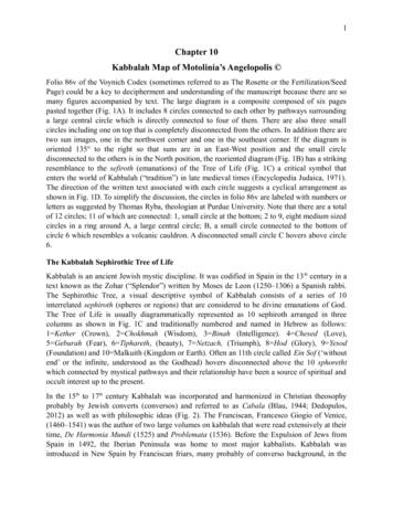
1Chapter 10Kabbalah Map of Motolinía’s Angelopolis Folio 86v of the Voynich Codex (sometimes referred to as The Rosette or the Fertilization/SeedPage) could be a key to decipherment and understanding of the manuscript because there are somany figures accompanied by text. The large diagram is a composite composed of six pagespasted together (Fig. 1A). It includes 8 circles connected to each other by pathways surroundinga large central circle which is directly connected to four of them. There are also three smallcircles including one on top that is completely disconnected from the others. In addition there aretwo sun images, one in the northwest corner and one in the southeast corner. If the diagram isoriented 135 to the right so that suns are in an East-West position and the small circledisconnected to the others is in the North position, the reoriented diagram (Fig. 1B) has a strikingresemblance to the sefiroth (emanations) of the Tree of Life (Fig. 1C) a critical symbol thatenters the world of Kabbalah (“tradition”) in late medieval times (Encyclopedia Judaica, 1971).The direction of the written text associated with each circle suggests a cyclical arrangement asshown in Fig. 1D. To simplify the discussion, the circles in folio 86v are labeled with numbers orletters as suggested by Thomas Ryba, theologian at Purdue University. Note that there are a totalof 12 circles; 11 of which are connected: 1, small circle at the bottom; 2 to 9, eight medium sizedcircles in a ring around A, a large central circle; B, a small circle connected to the bottom ofcircle 6 which resembles a volcanic cauldron. A disconnected small circle C hovers above circle6.The Kabbalah Sephirothic Tree of LifeKabbalah is an ancient Jewish mystic discipline. It was codified in Spain in the 13 th century in atext known as the Zohar (“Splendor”) written by Moses de Leon (1250–1306) a Spanish rabbi.The Sephirothic Tree, a visual descriptive symbol of Kabbalah consists of a series of 10interrelated sephiroth (spheres or regions) that are considered to be divine emanations of God.The Tree of Life is usually diagrammatically represented as 10 sephiroth arranged in threecolumns as shown in Fig. 1C and traditionally numbered and named in Hebrew as follows:1 Kether (Crown), 2 Chokhmah (Wisdom), 3 Binah (Intelligence). 4 Chesed (Love),5 Geburah (Fear), 6 Tiphareth, (beauty), 7 Netzach, (Triumph), 8 Hod (Glory), 9 Yesod(Foundation) and 10 Malkuith (Kingdom or Earth). Often an 11th circle called Ein Sof (‘withoutend’ or the infinite, understood as the Godhead) hovers disconnected above the 10 sphorethtwhich connected by mystical pathways and their relationship have been a source of spiritual andoccult interest up to the present.In the 15th to 17th century Kabbalah was incorporated and harmonized in Christian theosophyprobably by Jewish converts (conversos) and referred to as Cabala (Blau, 1944; Dedopulos,2012) as well as with philosophic ideas (Fig. 2). The Franciscan, Francesco Giogio of Venice,(1460–1541) was the author of two large volumes on kabbalah that were read extensively at theirtime, De Harmonia Mundi (1525) and Problemata (1536). Before the Expulsion of Jews fromSpain in 1492, the Iberian Peninsula was home to most major kabbalists. Kabbalah wasintroduced in New Spain by Franciscan friars, many probably of converso background, in the
2early 1500s. However, in the 16th century all forms of Kabbalah were banned by the SpanishInquisition in Spain along with other occult sciences, and King Philip II signed royal degrees onAugust 16, 1564 and January 25, 1569, which created the Tribunal of the Inquisition in the NewWorld. However, inquisitions in New Spain existed as early as 1522. During the first period(1522–62), inquisitions were conducted by local officials. With the arrival of the first bishops toNew Spain, the second period (1536-69) witnessed a rise in inquisitions in which early bishopsand archbishops served as inquisitors. The third period (1571-1820) saw the establishment of anofficial Tribunal of the Inquisition (Chuchiak, 2012; Don, 2010; Perry and Cruz, 1991; VillaFlores, 2006).Folio 86v as the Sephirothic Tree of LifeThere is a good fit between the Sephirothic tree and Voynich diagram (Table 1). Thus the highestcircle (C) which has no direct connection to the other circles in the diagram represents Ain Soph(God) as shown in Fig. 1C. Evidence that this is the case comes from is a symbol in circle C withthe form of a right angle ( ) (Fig. 3A) that has mystified interpreters of this folio. Since theHebrew alphabet may be written with ball-and-stick elements this symbol can be interpreted torepresents the letter dalet ( )ﬧ in Hebrew (D in the Latin alphabet) which is associated with thenumber 4 and has long been a symbol for the Tetragrammaton, the divine name of God (YHWHpronounce Yaweh in Hebrew and Jehovah in English).Similarly the small bottom circle (circle 1) in folio 86v (Fig. 3A) would be Malkuth (Kingdom orEarth). This is supported by the T-O symbol ( ) of circle 1. The T-O symbol consisting of acircle with three subsections based on a diameter and a single radius at right angles to thediameter is referred to as a Beatine or Beatus map attributed to a Spanish monk Baetus ofLiebana, a cmarca of Cantabria. The T-O map represents the physical world first described by the7th century scholar (Saint) Isador of Seville in his Etyomologiae (chapter 14) (Barney et al.2006). In many medieval maps the symbol related to three continents: Asia (large section),Europe, and Africa (Fig. 3B), and sometimes to the trinity. The T-O maps is found in theFlorentine Codex of Sahugan describing the four winds (Fig. 3C). The voynichese words incircle 1 are osal (ānocâ), otor (ātlāe), and opeey (āhuaai) or cPhey (pai).The large central circle A considered to be Tiphareth or Beauty is only directly connected tocircle 3,5,7,9. Furthermore the small circle B resembles a volcanic caldron and we believe this isnot a sephiroth but a location marker and indeed there are also volcanos in circle 2 and 4. Inconclusion, without B, the diagram of 86v consists of 10 connected circles and one disconnectedcircle which makes it identical in form to the Sephirothic Tree of Life shown in Fig 1C. Weconclude that the sephirothic tree of the kabbalah influenced the artist’s folio 86v diagram butthere is no evidence that this is its main purpose.
3Fig. 1. The Voynich rosette: (A) folio 86v as found in the Voynich codex; (B) folio 86vreoriented with the sun in East-West position, and disconnected circle North; (C) kabbalahsephirothic Tree of Life published in the 17th century by the Jesuit priest Athanasius Kircher,
4Oedipus Aegypiacus 1652–1654;(D) schematic diagram of folio 86v with labeling of circles anddirection of text.Fig. 2. Christian and philosophic kabbalah: (A) diagram of Tree of Life in Portae Lucis, (Portalof Light) a Latin work of 1516 by the Jewish convert Paolo Ricci; (B) Christian appropriation ofkabbalah; (C) portrait of Alexander Henderson by Martin Droeshout, 1632, showing philosophicinfluence of Kabbalah.Fig. 3. T-O maps: (A) Circle 1 of folio 86v; (B) medieval T-O map showing Asia, Europe, andAfrica; (Digital Scriptorium Huntington Catalog Database, San Marino, Huntington Library, HM64 (C) T-O map the Florentine Codex of Sahugan, Book VII (Anderson and Dibble, 1953).
5Table 1. Numbers and names of circles in Sephiroth in Kabbalah Tree of Life, and Voynichcircles in folio 86v.Sephirothnumber1SephirothnameEin 1BSuggested Aztec city co de Orizaba(Citlaltepetl)La Malinche(Matlalcuéyetl)Puebla de lasAngeles’ (CelestialCity of Jerusalem)HuejotzingoPopocatepetl[Pico de Orizaba(Citlaltepetl)]THE FOLIO 86v CIRCLES AS CITIESThere is another explanation of folio 86v that is not mutually exclusive with a kabbalahinterpretation. Folio 86v can be considered a map superimposed on a Sephirothic tree thatrepresents clusters of cities connected by a network of roads or pathways and volcanic landmarks(Fig. 4). We interpret folio 86v as a map of the cities surrounding Puebla des los Angeles (CircleA) to include Huejotzingo (Circle 2), Tlaxcala (Circle 4); Tecamachalco/Tepeaca (Circle 6), andVera Cruz/Zampoala (circle 8). The circles are described in more detail below.
6Fig. 4. Cities and volcanos in Nueva España combined with circles of folio 86v.Evidence that 86v represents a series of cities comes from the history of Nueva España in the 16 thcentury. The Franciscan missionary Toribio of Benavente O.F.M. (1482–1568) known asMotolinía, from the Nahuatl meaning “he is poor” (Fig. 5A&B), was one of the “twelveapostles” who arrived shortly after Cortés and attempted to help convert the Indians. He arrivedin the Valley of Mexico (Anahuac) in 1524 and resided in 1530 at the convent of at Huejotzingonear Tlaxcala and Texcoco. The Franciscans attempted to establish a New Jerusalem or City ofthe Angels (Puebla de Los Angeles, or Angelopolis) in 1530 (Lara, 2004, 2008). The location ofthis city is described as follows:“The site which the city of Los Angeles occupies is very good and the region is the best in allNew Spain. Five leagues to the north lies the city of Tlaxcallan and five leagues to the west isHuexotzinco. To the east, five leagues, is Tepellacac (Tepeyacac) [Tepeaca]. To the south liesthe hot region. Here, seven leagues away, are Itzocan and Cuauhquechollan; Cholollan (Cholula)and Totomiahuacan are two leagues and Calpa is five leagues distant. All these towns are large.To the east, forty leagues away, is the harbor of Vera Cruz, and the distance to Mexico is twentyleagues. The highway from the harbor of Vera Cruz to Mexico passed through the City of LosAngeles” (Motolinía, 1951).It is intriguing that some of these cities have been configured into a cross in one publication(Sambhu, 2013) as described by Motolinía, a concept not dissimilar to the kabbalah diagram.Puebla de los Angeles can also be found in a 1733 map (Fig. 5C).
7Fig. 5. (A) Franciscan friar, Toribio of Benavente (1482–1568) known as Motolinía. (B) Friar’smethod of teaching Indians using Spanish, Italian and Flemish pictures (Motolinía, 1951; ReyesValerio, 1964; Azpeitia, 1972; Carmelo Arredondo; Gurría Lacroix; and Niedermeier,2002). (C) Angelopolis, or Puebla de los Angeles, configured into a cross based on Motolinía.Circle 2 (Fig 6)The most detailed circle has a number of elements which suggests that it represents the city ofHuejotzingo, a small city in Puebla in central Mexico that still exists (Fig. 7A). There arealternate spellings on maps and documents of the 16th century as Huexucinco, Huexutcinco, andHuexotzinco and, found in a map from 1691, the spelling of Guazocingo (Fig. 7B). Prominent incircle 2 is a fortified structure with crenelated battlements that resemble the fortified monasteryof San Miguel Arcangel at Huejotzingo that was constructed as early as 1530 (Motolinía, 1951)but re-constructed as the “Queen of the Missions” from 1544 to 1570 (Gracia Granados and MacGregor, 1934) (Fig. 8).
8Fig. 6. Circle 2 (Huejotzingo) connected to circle 1.Fig. 7. Huejotzingo: (A) contemporary map of central Mexico, (B) Map of 1691 with spelling ofGuazocingo (Copper-plate engraving from Jan Karel Donatus Van Beecq, 1638–1722).
9Fig. 8. Landmarks in circle 2: (A) Illustration fortified monastery in circle 2 of fol. 86v withmerlons (also called Ghibelline battlements or priest caps); (B) contemporary picture of the frontview of San Miguel Arcangel in Huejotzingo showing attached aqueduct; (C) contemporaryviews of the San Miguel Arcangel in Huejotzingo showing triangular pierced merlons along thewalls as well as swallow-tail battlements on the stepped buttresses; (D) view of Popocatepetlfrom the roof of the monastery (Garcia Granados and Mac Gregor, 1934); (E) three towers and asingle tower with names in Circle 2.This monastery has a unique architecture that is a mix of medieval and Renaissance styles, withPlateresque and Moorish elements. It was designed in 1544 by Fray Juan de Alameda, heavilybased on Italian models: “Native encomienda laborers built the convento that Alameda designedbased on his familiarity with European Monastic compounds. The friar also relied on Europeanarchitectural treatises including Leon Battista Alberti’s De re aedifacatoria (1485), Vitruvius’sDe architectura (1486), Sebastino Serlio’s Regole generali di architettura (1537, Spanish edition1565), and Dieto de Sagredo’s Medidas del romano (1526). The variety of structural and formalsolutions displayed at Huejotzingo and New Spain’s other monastic compounds suggest,however, that treatises and European models were not the architect’s only sources of inspiration.Constructing monuments for this new Christian república de indios meant deploying an array offorms to create an ideal mission setting.” (Donahue-Wallace, 2008).The structure was not completed until 1570 when presumably the triangular pierced merlonswere added. The merlons in the drawing of circle 2 of 86v are considered M-shaped swallowtail(pyramidal). However the merlons on the stepped buttresses of the resemble swallow tailmerlons (Perry, 1992, and may have been used by the Voynich artist to sketch the uncompleted
10fortress. The Voynich arts also used swallow tail merlons in a sketch found in the passageway tocircle 6. (see Fig. 11).Its attached aqueduct was fed by runoff from slopes of Popocatepetl via the Xopanac River. Thesmoking volcano, most obviously Popocatepetl, can be seen in the rim of the circle with thefollowing words emanating: odaShmsain (a ch o tz ya/ha o n o l). Connected to the fortress area long wall with towers, one of which contains the name opoor daly (āhuāāe chocâi). In thecenter of the inner circle are four towers with Moorish domes. In addition there are 118 sixpointed stars evenly distributed and in their midst in a spiral of words. In the passage way tocircle 9 a number of structures are indicated, and in the passageway to circle 3 there are threetowers with the name oteedy otoldy (ātlaachi ātlācâchi) above. Atlacachi refers to spearthrowers or fishermen in Nahuatl: “Settlers of the islands and shores were called Atlacachichimeca, which probably means “los chichimeca con atlatl” [chichimeca with spear throwers] or“los del cordelo/linaje de perro hombres del agua” [those of the cordage/water dog men lineage](Molina 1977:8, 78, 95), and their tools consisted of the net, the atlatl (spear-throwers), and theharpoon.” (Staedtler and Hernández, 2003).The entire circle is ringed by words. Elements in circle 2 representing fire air, water, and earthsuggest Kabbalah/Aristotelian allusions of the Universe. Fire and dust is alluded to by thesmoking Popocatepetl; five strange finger-like clouds might represent wind or air, and alternatingblue and yellow stripes suggest water.The association of the fortified building as the monastery in Huejotzingo is more than aconjecture. Firstly, very few of the monasteries in New Spain had crenelated battlements whichis found in the present structure at Huejotzingo (Perry, 1993), but none other had swallow-tailmerlons. In addition, a convincing case can be made that the fortified structure in circle 2 is themonastery San Miguel Arcangel in Huejotzingo since its name in Voynichese is written abovethe structure. This translation is based on the decipherment of some of the Nahuatl plant namesin the Voynich document by Tucker and Talbert (2013). The letters pairotalcPhy above can betransliterated as hu/gu–o-sh/x-e-ā-tl-o-câ-p-i. Huexotl is the Classical Nahuatl stem for willow,while capi is a 16th century Spanish word meaning a capital city in Latin America. ThusHuoxeatlcapi would literally be “willow capital,” against the Classical Nahuatl derivation ofHuejotzingo (Huexucinco/Huexutcinco/Huexotzinco), which literally translates as “where thewillows grow.” We suggest that this decipherment may be a smoking gun which does two things:(1) it confirms the decipherment of the plant names, and (2) it verifies circle 2 as the cityHuejotzingo. It also confirms that most of the words found in circle 2 are not Classical Nahuatlbut must be based on a similar extinct dialect or language.Circle A (Fig. 9). The central largest circle is surrounded by 8 others of which circles 3, 5, 7, 9,cosmological in nature, are directly connected. Circle A is composed of three rings: the outer ringcontains 12 sets of six raised pipes evenly distributed (an unseen spike may be in the crease); athin middle ring with cell-like structures, and an inner ring contains a three dimensional image ofa mantle covered with five or six pointed stars supported by six domes (qubba) or ciboria. There
11are five words written between the domes [otdoda-oegy (ātlchācho-āahi), soSex-s arar(nāts/tz?-n oeoe), otedaiin-otedy (ātlacholl-ātlachi), ytedara-y (itlachoeo-i), opce-daiin(āhum-choll)]. Some of these words have Nahuatl cognates:atl waterchacho sprinkledcholl may be related to Chollula/Cholula, a pre-Columbian Aztec city.itla somethingThus, atlchacho (atl water; chaco sprinked) -aahi suggests “holy” or “blessed” -aahi (lastincomplete term unknown). In the Church of San Francisco at Puebla there is a chapel with the“incorrupt” remains of Blessed Sebastian di Aparicio y del Pardo (1502–1600). Similarly thewords altlacholli-atlachi, might refer to fisherman of Cholula.This image in circle A, the central large circle in folio 86v, is obviously theological in nature. Thestarry mantle may allude to the mantle of Elijah or Elisha and is suggestive of the starry mantleof Our Lady of Guadalupe shown in a painting now located in the Basilica of Mexico City thatdates to 1531. We are convinced that this circle represents the Celestial City of Jerusalem calledPuebla de Los Angeles (Angelopolis) now known as Puebla. According to Motolinía the city wasfound in 1530 with the hope of it being “settled by people who instead of all waiting to haveIndians assigned to them, would devote themselves to tilling the field and cultivating the land inthe Spanish way.” A 1733 map of Mexico shows the location of Puebla de Los Angeles (Fig. 9).A strikingly similar representation of Jerusalem is a Psalter-fragment (The Hague, KB, 76 F 5)from 1200 (Fig. 10). This is one of eleven copies of an abbreviated map of Jerusalem, all broadlyalike in the street plan and buildings of the city with qubba and crucifix to mark each holy site(Harvey, 2012).This circular arrangement of six qubba around a central holy area also bears an uncannyresemblance to the map of Cholula (De chollola) from the Relación Geográfica of 1581 (Mundy,2000) (Fig. 11). This shows a central Franciscan monastic complex (“Ciudad S.Gabriel. Anctayglessia, Cabila”).with Cholula’s largest pre-Hispanic pyramid, the tlachihuatl tepetl, pictured atupper right and named “Tollan Cholulā.” Then, arranged round this complex, six convento, eachwith a crucifix and a qubba-like mound to the rear (probably representing previous pagantemples), are (clockwise from upper right):(1) “Sanct. Andres Cabezeras,” possibly Ex Convento de San Andrés Calpan, Puebla or ExConvento San Diego, San Andrés, Cholula;(2) “Sanct. Pablo Cabezera,” possibly Ex Convento de San Pablo de los Frailes, Puebla de losÁngeles;(3) “Sanct. Maria Cabezera,” possibly Ex Convento de Santa María, Tepapayeca or Santa Mariade la Concepción, Atlihuetzía, Tlaxcala;
12(4) “Sanct. Juan Cabezera,” possibly Ex-Convento de San Juan Bautista, Cuauhtinchán, Puebla;(5) “Sanctjago. [Santiago] Cabezera,” possibly Ex Convento de Santiago Apóstol, Cuilapam,Oaxaca;(6) “Sanct. Miguel Tecpan Cabezera,” possibly San Miguel Tecpan, Jilotzingo.Fig. 9. Circle A as Puebla de los Angeles (left); 1812 map (Spanish Dominions in NorthAmerica) of central Mexico indicating the location of Puebla de los Angeles (right).
13Fig. 10. Abbreviated map of Jerusalem from 1200 (Koninklijke Bibliotheek National Libraryof the Netherlands).
14Fig. 11. Cholula (De chollola) from the Relación Geográfica of 1581 (Mundy, 2000).Circle 4 (Fig. 12A). We suggest this circle represents Tlaxcala the city entered by Cortés on hisway to Tenochtitlan, whose name in Nahuatl means “the place of maize tortillas.” The populationwas 300,000 in the 16th century. There was a large fountain and square in the center of thecolonial city which might be represented by the blue cross with a circle at its center. Next to theblue cross is a large rectangular area with rows that seems to represent the rows of a prominentmarketplace (tiend) behind the fountain and square. This matches the plan of central Tlaxcala inthe 16th century (Fig. 12B). A stone fountain in the center of plaza was erected 1548 by FrayFrancisco de las Navas and Diego Ramírez, the second registered Corregidor. Water from theZahuapan River came to this fountain by a conduit, and this was used as a supply for drinkingwater for miles around. Tiendas, or shops, were to the southwestern and southeastern sides of theplaza as early as 1549 (Gibson, 1952). There are six poles. There are two patches filled withstars. The volcano on the edge pointing to Circle A would be La Malinche (Matlalcuéyetl), thelargest volcano in Tlaxcala.
15Fig. 12. (A) Circle 4 (Tlaxcala); (B) map of “Tlaxcala (Gibson, 1952).Circle 6, B, and C (Fig. 11). We propose Circle 6 (Fig 11A) represents Tecamachalco, Pueblarather than the nearby city of Tepeaca. The Franciscans arrived in Tecamachalco in 1541. Thechurch, Asuncion De Nuestra Senora (Fig. 12B), was dedicated in 1551 and completed by 1557.During this time Andrés de Olmos, Francisco de las Navas, and Toribios de Benavente (known asMotolinía) resided in this dusty outpost and taught the local indigenous peoples not only therudiments of Christianity, but also the tenets of European art. At the same time, the diseasesbrought by the Spanish resulted in unremitting loss of life for the indigenous population. The16th century saw three major epidemics in Tecamachalco (1520, 1542, and 1577). Theauthorities estimated that 90% of the native population in the area had disappeared by 1580. Fortheir part, the Franciscans fervently believed that the evangelization of the indigenous populationof the New World was essential to precipitate the second coming of Christ. Not surprisingly,Motolinía drew parallels between the epidemics and famine that were decimating the nativepeoples and the disastrous events described in Revelation announcing the imminent return ofChrist. The Apocalypse gave meaning to this tragedy of human suffering (Acuna-Soto et al.2002; Marr and Kirkacofe, 2000).Asuncion De Nuestra Senora contains 27 paintings in North Renaissance style by the indigenousladino mestizo artist (tlacuilo) christened Juan Gerson painted in the mid 16th century. The churchhas four ribs with a Franciscan rosette in the center (Fig. 11C) as suggested by the central ringrepresenting the five wounds of Christ. Gerson’s paintings, on native amatl paper, appear to bebased on woodcuts from Bibles published in Germany and France in the 15 th and 16th centuries.Flemish and Italian paintings were also used as models to train Indians in the colleges set up bythe Friars (Fig. 5B). The paintings of Gerson include many scenes from the Hebrew Bible andinclude a panel called Jerusalem and the City of God (Azpeitia, 1972; Boone and Cummins,1998; Carmelo Arredondo et al., 1964). There are a number of strange shapes in blue and white
16stripes in that circle which are unexplainable. The circle B is connected to Circle 6 in the south,without any words and probably represents the stratovolcano Pico de Orizaba (Citlaltepetl), thehighest mountain in Mexico, 47 km from Tecamachalco, and dormant since 1687. We havealready commented on Circle C the small disconnected circle above Circle 6 with the ball-andstick figure.In the large passageway associated with Circle 6 there is a long structure with swallow-tailedmerlons. We suggest that this structure could very well be the aqueduct connected to the Churchthat is now in ruins; a number of aqueducts in colonial Nueva Espana do shows merlons. Aphotograph of the present church Asuncion De Nuestra Senora (Fig. 11B) shows a connectedaqueduct. We consider this further evidence that Circle 6 represents Tecamachalco.Fig. 11. (A) Circle 6 (Tecamachalco); (B) Asuncion De Nuestra Senora church with connectedaqueduct; (C) Interior ceiling with paintings of the tlaquilo Juan Gerson.Circle 8 (Fig. 12). This circle composed of two rings can be associated with the Vera Cruz areaon the East Coast of Mexico based on four elements: (1) the six large pipes emanating from theoutside of the circle could represent the six chimneys in the ruins of the Temple of the Chimneysat the city of Zempoala (Cempoala) (Fig. 13), an ancient Mesoamerican archeological site northof Vera Cruz; (2) the structure in the passageway to circle 9 is interpreted to be an ancientlighthouse/monastery in Vera Cruz; (3) the large oval shape in the inner circle might representthe large fresh water lake Laguna Catemaco in Vera Cruz; (4) a Voynichese name in orange
17tinted area (otcedasas) in the inner circle can be deciphered as āltmchonon water sellerbased on Nahuatl cognates: atl m aca water someone and chonon seller. The residents ofvarious towns had nicknames (Furbee et al., 2010) and the names associated with Vera Cruzinclude chono trago or aguadiente sellers (bootleggers) which would be redolent of water sellers.Vera Cruz was a bustling city when Cortés landed but was severely decimated by smallpox, andby 1577, only 30 households remained, and these were relocated and the town abandoned; onlytwo inhabitants were recorded in 1600. The Temple at Zempoala was covered by forest and fellapart, only to be rediscovered in 1891 by Francisco del Paso y Troncoso, but the bulk of the workwas done in the 1940s by García Payón. The Temple was important to predict the phases of themoon. The initial Franciscan conventos in Vera Cruz were wooden but were decimated by twofires in the 17th century. They also served as light houses at some point and were built on apromontory at the port above the Gulf. The latest version of the Franciscan monastery was laternationalized and is now a Holiday Inn. Approximately 35% of the fresh water in Mexico is inVera Cruz, and Laguna Catemaco. a freshwater lake there in sight of the Gulf of Mexico(Carrasco, 1999).Fig. 12. Circle 8.Fig. 13. Remains of 5 chimneys from theruins of the Temple of the Chimneys,Zempoala (Cempoala).Circles 3, 5, 7, 9. (Fig. 14). These four circles appear cosmological in nature. Circle 3 is verystrange with an outer circle consisting of small ball-like forms and associated with 16protuberances or undulations. The circle form in the center containing a small inner circle at thecenter connected to two winglike forms. The inner area is filled with blue marks. The 16undulations show a resemblance to the seven legendary caves of Chicomoztoc (Fig. 15) the
18legendary location for the Aztecs origins (Carrasco and Sessions, 2007; Rossell, 2006). Pico deOrizaba in the State of Puebla has many small caves that were used for rituals before theConquest and this circle 3 may refer to this area.Circles 5, 7, and 9 are similar and appear to be wheels with spokes or ribs: 7 in Circle 5, 8 inCircle 7, and 15 in Circle 9. The spokes in each are associated with names (Table 2).Fig 14. Circles 3, 5, 7, 9.
19Table 2. Words in circle 5, 7, and 9 in Voynichese listed in alphabetical order.Circle 5Circle 7Circle �tlāei)otcedy chālli)d x os(ch?ān)adoisy(ochāshni)Circles 5, 7, and 9 are similar and appear to be wheels with spokes or ribs: 7 in Circle 5, 8 inCircle 7, and 15 in Circle 9. The spokes in each are associated with names (Table 2).The three circle (5, 7, and 9) resemble a wheel with 7, 8, and 13 spokes that terminate in an areawith 8, 8, and 10 words, respectively (Fig. 1), that must be nouns. Since circles 2, 4, 6, and 8 arecities, the words in circles 5, 7, 9 may be related to villages or towns. The 26 words in thesecircles have been alphabetized and compared to cities in the area surrounding Puebla in Table 3and some seem close. The words Altaachi and Atlachi refer to spear throwers or fishermen inNahuatl and may be small Lake villages (Staedtler et al., 2006). Thus, the 8 circles surroundingcircle A (The Celestial City of Jerusalem founded by Motolinía in 1530) makes sense as ametaphoric map surrounding Puebla. It seems probably that many of the small villages or townsreferred to could have disappeared or have had their names altered.
20The similarities of the words in circles 5, 7, and 9 might that the words might also beincantations involving drought since of the 26 words, 15 begin with the term ot or ātl, a Nahuatlcognate that concerns water, and 4 words that begin with op or āhu might refer to something drysince ahuoj dry arroyo/dry creek. Note that the word atlachi or atlaachi is found in all threecircles. The repeated droughts in the 16th century (1545–1575), the worst in 500 years (AcunaSoto et al., 2002) was one of the causes of increased human sacrifice among the Aztecs and thewords could very well have been associated with incantations for rain.Table 3. Deciphered words in the circles 5, 7, 9 compared to towns in states of Mexico (DistrictFederal, Hildago, Mexico, Puebla, Tlaxcala, Vera Cruz, Guanajuato, and Queretaro) that wereobtained from Directory of Cities and towns in Mexico (Falling Rain Genomi
The Kabbalah Sephirothic Tree of Life Kabbalah is an ancient Jewish mystic discipline. It was codified in Spain in the 13th century in a text known as the Zohar (“Splendor”) written by Moses de Leon (1250–1306) a Spanish rabbi. The Sephirothic Tree, a visual descriptive symbo