Transcription
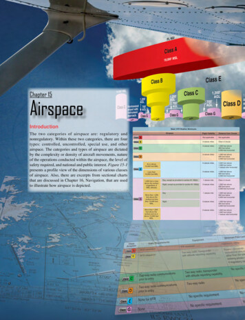
Chapter 15AirspaceIntroductionThe two categories of airspace are: regulatory andnonregulatory. Within these two categories, there are fourtypes: controlled, uncontrolled, special use, and otherairspace. The categories and types of airspace are dictatedby the complexity or density of aircraft movements, natureof the operations conducted within the airspace, the level ofsafety required, and national and public interest. Figure 15-1presents a profile view of the dimensions of various classesof airspace. Also, there are excerpts from sectional chartsthat are discussed in Chapter 16, Navigation, that are usedto illustrate how airspace is depicted.15-1
FL 600ClassA18,000' MSLClassBClass14,500' MSLClassGNontoweredairport Nontoweredairport withno instrumentapproachGFigure 15-1. Airspace profile.Controlled AirspaceControlled airspace is a generic term that covers thedifferent classifications of airspace and defined dimensionswithin which air traffic control (ATC) service is providedin accordance with the airspace classification. Controlledairspace consists of: Class A Class B Class C Class D Class EClass A AirspaceClass A airspace is generally the airspace from 18,000 feetmean sea level (MSL) up to and including flight level (FL)600, including the airspace overlying the waters within 12nautical miles (NM) of the coast of the 48 contiguous statesand Alaska. Unless otherwise authorized, all operation in ClassA airspace is conducted under instrument flight rules (IFR).Class B AirspaceClass B airspace is generally airspace from the surface to10,000 feet MSL surrounding the nation’s busiest airports interms of airport operations or passenger enplanements. Theconfiguration of each Class B airspace area is individuallytailored, consists of a surface area and two or more layers(some Class B airspace areas resemble upside-down weddingcakes), and is designed to contain all published instrumentprocedures once an aircraft enters the airspace. ATCclearance is required for all aircraft to operate in the area,and all aircraft that are so cleared receive separation serviceswithin the airspace.15-2Class C AirspaceClass C airspace is generally airspace from the surface to4,000 feet above the airport elevation (charted in MSL)surrounding those airports that have an operational controltower, are serviced by a radar approach control, and have acertain number of IFR operations or passenger enplanements.Although the configuration of each Class C area isindividually tailored, the airspace usually consists of a surfacearea with a five NM radius, an outer circle with a ten NMradius that extends from 1,200 feet to 4,000 feet above theairport elevation. Each aircraft must establish two-way radiocommunications with the ATC facility providing air trafficservices prior to entering the airspace and thereafter mustmaintain those communications while within the airspace.Class D AirspaceClass D airspace is generally airspace from the surface to2,500 feet above the airport elevation (charted in MSL)surrounding those airports that have an operational controltower. The configuration of each Class D airspace area isindividually tailored and, when instrument procedures arepublished, the airspace is normally designed to contain theprocedures. Arrival extensions for instrument approachprocedures (IAPs) may be Class D or Class E airspace. Unlessotherwise authorized, each aircraft must establish two-wayradio communications with the ATC facility providing airtraffic services prior to entering the airspace and thereaftermaintain those communications while in the airspace.Class E AirspaceClass E airspace is the controlled airspace not classified asClass A, B, C, or D airspace. A large amount of the airspaceover the United States is designated as Class E airspace.
This provides sufficient airspace for the safe control andseparation of aircraft during IFR operations. Chapter 3 ofthe Aeronautical Information Manual (AIM) explains thevarious types of Class E airspace.Sectional and other charts depict all locations of Class Eairspace with bases below 14,500 feet MSL. In areas wherecharts do not depict a class E base, class E begins at 14,500feet MSL.In most areas, the Class E airspace base is 1,200 feet AGL. Inmany other areas, the Class E airspace base is either the surfaceor 700 feet AGL. Some Class E airspace begins at an MSLaltitude depicted on the charts, instead of an AGL altitude.Class E airspace typically extends up to, but not including,18,000 feet MSL (the lower limit of Class A airspace). Allairspace above FL 600 is Class E airspace.Uncontrolled AirspaceClass G AirspaceUncontrolled airspace or Class G airspace is the portion ofthe airspace that has not been designated as Class A, B, C,D, or E. It is therefore designated uncontrolled airspace.Class G airspace extends from the surface to the base of theoverlying Class E airspace. Although ATC has no authorityor responsibility to control air traffic, pilots should rememberthere are visual flight rules (VFR) minimums that apply toClass G airspace.Prohibited AreasProhibited areas contain airspace of defined dimensionswithin which the flight of aircraft is prohibited. Such areasare established for security or other reasons associated withthe national welfare. These areas are published in the FederalRegister and are depicted on aeronautical charts. The area ischarted as a “P” followed by a number (e.g., P-40). Examplesof prohibited areas include Camp David and the NationalMall in Washington, D.C., where the White House and theCongressional buildings are located. [Figure 15-2]Restricted AreasRestricted areas are areas where operations are hazardous tononparticipating aircraft and contain airspace within whichthe flight of aircraft, while not wholly prohibited, is subjectto restrictions. Activities within these areas must be confinedbecause of their nature, or limitations may be imposed uponaircraft operations that are not a part of those activities, orboth. Restricted areas denote the existence of unusual, ofteninvisible, hazards to aircraft (e.g., artillery firing, aerialgunnery, or guided missiles). IFR flights may be authorizedto transit the airspace and are routed accordingly. Penetrationof restricted areas without authorization from the usingor controlling agency may be extremely hazardous to theaircraft and its occupants. ATC facilities apply the followingprocedures when aircraft are operating on an IFR clearance(including those cleared by ATC to maintain VFR on top) viaa route that lies within joint-use restricted airspace:1.If the restricted area is not active and has been releasedto the Federal Aviation Administration (FAA), theATC facility allows the aircraft to operate in therestricted airspace without issuing specific clearancefor it to do so.2.If the restricted area is active and has not been releasedto the FAA, the ATC facility issues a clearance thatensures the aircraft avoids the restricted airspace.Special Use AirspaceSpecial use airspace or special area of operation (SAO)is the designation for airspace in which certain activitiesmust be confined, or where limitations may be imposedon aircraft operations that are not part of those activities.Certain special use airspace areas can create limitations onthe mixed use of airspace. The special use airspace depictedon instrument charts includes the area name or number,effective altitude, time and weather conditions of operation,the controlling agency, and the chart panel location. OnNational Aeronautical Charting Group (NACG) en routecharts, this information is available on one of the end panels.Special use airspace usually consists of: Prohibited areas Restricted areas Warning areas Military operation areas (MOAs) Alert areas Controlled firing areas (CFAs)Figure 15-2. An example of a prohibited area, P-40 around CampDavid.15-3
Restricted areas are charted with an “R” followed by anumber (e.g., R-4401) and are depicted on the en routechart appropriate for use at the altitude or FL being flown.[Figure 15-3] Restricted area information can be obtainedon the back of the chart.Warning AreasWarning areas are similar in nature to restricted areas;however, the United States government does not have solejurisdiction over the airspace. A warning area is airspace ofdefined dimensions, extending from 3 NM outward fromthe coast of the United States, containing activity that maybe hazardous to nonparticipating aircraft. The purpose ofsuch areas is to warn nonparticipating pilots of the potentialdanger. A warning area may be located over domestic orinternational waters or both. The airspace is designated witha “W” followed by a number (e.g., W-237). [Figure 15-4]Military Operation Areas (MOAs)MOAs consist of airspace with defined vertical and laterallimits established for the purpose of separating certainmilitary training activities from IFR traffic. Whenever anMOA is being used, nonparticipating IFR traffic may becleared through an MOA if IFR separation can be provided byATC. Otherwise, ATC reroutes or restricts nonparticipatingIFR traffic. MOAs are depicted on sectional, VFR terminalarea, and en route low altitude charts and are not numbered(e.g., “Camden Ridge MOA”). [Figure 15-5] However, theMOA is also further defined on the back of the sectionalcharts with times of operation, altitudes affected, and thecontrolling agency.Alert AreasAlert areas are depicted on aeronautical charts with an “A”followed by a number (e.g., A-211) to inform nonparticipatingFigure 15-3. Restricted areas on a sectional chart.15-4Figure 15-4. Requirements for airspace operations.pilots of areas that may contain a high volume of pilot trainingor an unusual type of aerial activity. Pilots should exercisecaution in alert areas. All activity within an alert area shallbe conducted in accordance with regulations, without waiver,and pilots of participating aircraft, as well as pilots transitingthe area, shall be equally responsible for collision avoidance.[Figure 15-6]Controlled Firing Areas (CFAs)CFAs contain activities that, if not conducted in a controlledenvironment, could be hazardous to nonparticipating aircraft.The difference between CFAs and other special use airspaceis that activities must be suspended when a spotter aircraft,radar, or ground lookout position indicates an aircraft mightbe approaching the area. There is no need to chart CFAssince they do not cause a nonparticipating aircraft to changeits flight path.Other Airspace Areas“Other airspace areas” is a general term referring to themajority of the remaining airspace. It includes: Local airport advisory (LAA) Military training route (MTR) Temporary flight restriction (TFR) Parachute jump aircraft operations Published VFR routes Terminal radar service area (TRSA) National security area (NSA) Air Defense Identification Zones (ADIZ) land andwater based and need for Defense VFR (DVFR) flightplan to operate VFR in this airspace Intercept Procedures and use of 121.5 forcommunication if not on ATC already
Figure 15-5. Camden Ridge MOA is an example of a military operations area.Figure 15-6. Alert area (A-211).15-5
Flight Restricted Zones (FRZ) in vicinity of Capitoland White House Special Awareness Training required by14 CFR 91.161 for pilots to operate VFR within 60NM of the Washington, DC VOR/DME Wildlife Areas/Wilderness Areas/National Parks andrequest to operate above 2,000 AGL National Oceanic and Atmospheric Administration(NOAA) Marine Areas off the coast with requirementto operate above 2,000 AGL Tethered Balloons for observation and weatherrecordings that extend on cables up to 60,000Local Airport Advisory (LAA)An advisory service provided by Flight Service Station(FSS) facilities, which are located on the landing airport,using a discrete ground-to-air frequency or the towerfrequency when the tower is closed. LAA services includelocal airport advisories, automated weather reporting withvoice broadcasting, and a continuous Automated SurfaceObserving System (ASOS)/Automated Weather ObservingStation (AWOS) data display, other continuous direct readinginstruments, or manual observations available to the specialist.Military Training Routes (MTRs)MTRs are routes used by military aircraft to maintainproficiency in tactical flying. These routes are usuallyestablished below 10,000 feet MSL for operations at speedsin excess of 250 knots. Some route segments may be definedat higher altitudes for purposes of route continuity. Routesare identified as IFR (IR), and VFR (VR), followed bya number. [Figure 15-7] MTRs with no segment above1,500 feet AGL are identified by four number characters(e.g., IR1206, VR1207). MTRs that include one or moresegments above 1,500 feet AGL are identified by threenumber characters (e.g., IR206, VR207). IFR low altitudeen route charts depict all IR routes and all VR routes thataccommodate operations above 1,500 feet AGL. IR routesare conducted in accordance with IFR regardless of weatherconditions. VFR sectional charts depict military trainingactivities, such as IR, VR, MOA, restricted area, warningarea, and alert area information.Temporary Flight Restrictions (TFR)A flight data center (FDC) Notice to Airmen (NOTAM)is issued to designate a TFR. The NOTAM begins withthe phrase “FLIGHT RESTRICTIONS” followed by thelocation of the temporary restriction, effective time period,area defined in statute miles, and altitudes affected. TheNOTAM also contains the FAA coordination facility andtelephone number, the reason for the restriction, and any otherinformation deemed appropriate. The pilot should check theNOTAMs as part of flight planning.Some of the purposes for establishing a TFR are: Protect persons and property in the air or on the surfacefrom an existing or imminent hazard. Provide a safe environment for the operation ofdisaster relief aircraft. Prevent an unsafe congestion of sightseeing aircraftabove an incident or event, that may generate a highdegree of public interest. Protect declared national disasters for humanitarianreasons in the State of Hawaii. Protect the President, Vice President, or other publicfigures. Provide a safe environment for space agencyoperations.Since the events of September 11, 2001, the use of TFRs hasbecome much more common. There have been a number ofincidents of aircraft incursions into TFRs that have resultedin pilots undergoing security investigations and certificatesuspensions. It is a pilot’s responsibility to be aware of TFRsin their proposed area of flight. One way to check is to visitthe FAA website, www.tfr.faa.gov, and verify that there isnot a TFR in the area.Parachute Jump Aircraft OperationsParachute jump aircraft operations are published in the ChartSupplement U.S. (formerly Airport/Facility Directory). Sitesthat are used frequently are depicted on sectional charts.Military TrainingRoute (MTR)Figure 15-7. Military training route (MTR) chart symbols.15-6Published VFR RoutesPublished VFR routes are for transitioning around, under, orthrough some complex airspace. Terms such as VFR flyway,VFR corridor, Class B airspace VFR transition route, andterminal area VFR route have been applied to such routes.
These routes are generally found on VFR terminal areaplanning charts.Terminal Radar Service Areas (TRSAs)TRSAs are areas where participating pilots can receiveadditional radar services. The purpose of the service isto provide separation between all IFR operations andparticipating VFR aircraft.The primary airport(s) within the TRSA become(s) Class Dairspace. The remaining portion of the TRSA overlies othercontrolled airspace, which is normally Class E airspacebeginning at 700 or 1,200 feet and established to transition to/from the en route/terminal environment. TRSAs are depictedon VFR sectional charts and terminal area charts with a solidblack line and altitudes for each segment. The Class D portionis charted with a blue segmented line. Participation in TRSAservices is voluntary; however, pilots operating under VFRare encouraged to contact the radar approach control and takeadvantage of TRSA service.National Security Areas (NSAs)NSAs consist of airspace of defined vertical and lateraldimensions established at locations where there is arequirement for increased security and safety of groundfacilities. Flight in NSAs may be temporarily prohibited byregulation under the provisions of Title 14 of the Code ofFederal Regulations (14 CFR) part 99, and prohibitions aredisseminated via NOTAM. Pilots are requested to voluntarilyavoid flying through these depicted areas.Air Traffic Control and the NationalAirspace SystemThe primary purpose of the ATC system is to prevent acollision between aircraft operating in the system and toorganize and expedite the flow of traffic. In addition toits primary function, the ATC system has the capability toprovide (with certain limitations) additional services. Theability to provide additional services is limited by manyfactors, such as the volume of traffic, frequency congestion,quality of radar, controller workload, higher priority duties,and the pure physical inability to scan and detect thosesituations that fall in this category. It is recognized that theseservices cannot be provided in cases in which the provisionof services is precluded by the above factors.Consistent with the aforementioned conditions, controllersshall provide additional service procedures to the extentpermitted by higher priority duties and other circumstances.The provision of additional services is not optional on thepart of the controller, but rather is required when the worksituation permits. Provide ATC service in accordance withthe procedures and minima in this order except when:1.A deviation is necessary to conform to ICAODocuments, National Rules of the Air, or specialagreements where the United States provides ATCservice in airspace outside the country and itspossessions2.Other procedures/minima are prescribed in a letter ofagreement, FAA directive, or a military document3.A deviation is necessary to assist an aircraft when anemergency has been declaredCoordinating the Use of AirspaceATC is responsible for ensuring that the necessarycoordination has been accomplished before allowing anaircraft under their control to enter another controller’s areaof jurisdiction.Before issuing control instructions directly or relayingthrough another source to an aircraft that is within anothercontroller’s area of jurisdiction that will change thataircraft’s heading, route, speed, or altitude, ATC ensuresthat coordination has been accomplished with each of thecontrollers listed below whose area of jurisdiction is affectedby those instructions unless otherwise specified by a letterof agreement or a facility directive:1.The controller within whose area of jurisdiction thecontrol instructions are issued2.The controller receiving the transfer of control3.Any intervening controller(s) through whose area ofjurisdiction the aircraft will passIf ATC issues control instructions to an aircraft through asource other than another controller (e.g., Aeronautical Radio,Incorporated (ARINC), FSS, another pilot), they ensure thatthe necessary coordination has been accomplished with anycontrollers listed above, whose area of jurisdiction is affectedby those instructions unless otherwise specified by a letterof agreement or a facility directive.Operating in the Various Types of AirspaceIt is important that pilots be familiar with the operationalrequirements for each of the various types or classes ofairspace. Subsequent sections cover each class in sufficientdetail to facilitate understanding regarding weather, type ofpilot certificate held, and equipment required.Basic VFR Weather MinimumsNo pilot may operate an aircraft under basic VFR when theflight visibility is less, or at a distance from clouds that isless, than that prescribed for the corresponding altitude andclass of airspace. [Figure 15-8] Except as provided in 14 CFRpart 91, section 91.157, “Special VFR Weather Minimums,”15-7
Basic VFR Weather MinimumsAirspaceFlight VisibilityDistance from CloudsClassANot applicableNot applicableClassB3 statute milesClear of cloudsC3 statute milesClass1,000 feet above500 feet below2,000 feet horizontalClassD3 statute miles1,000 feet above500 feet below2,000 feet horizontal5 statute miles1,000 feet above1,000 feet below1 statute mile horizontal3 statute miles1,000 feet above500 feet below2,000 feet horizontalDay, except as provided in section 91.155(b)1 statute mileClear of cloudsNight, except as provided in section 91.155(b)3 statute miles1,000 feet above500 feet below2,000 feet horizontalDay1 statute mile1,000 feet above500 feet below2,000 feet horizontalNight3 statute miles1,000 feet above500 feet below2,000 feet horizontal5 statute miles1,000 feet above1,000 feet below1 statute mile horizontalAt or above10,000 feet MSLClassELess than10,000 feet MSL1,200 feet or lessabove the surface(regardless ofMSL altitude).ClassGMore than 1,200feet above thesurface but lessthan 10,000 feetMSL.More than 1,200feet above thesurface and at orabove 10,000 feetMSL.Figure 15-8. Visual flight rule weather minimums.no person may operate an aircraft beneath the ceiling underVFR within the lateral boundaries of controlled airspacedesignated to the surface for an airport when the ceiling isless than 1,000 feet. Additional information can be found in14 CFR part 91, section 91.155(c).Operating Rules and Pilot/Equipment RequirementsThe safety of flight is a top priority of all pilots and theresponsibilities associated with operating an aircraftshould always be taken seriously. The air traffic systemmaintains a high degree of safety and efficiency with strictregulatory oversight of the FAA. Pilots fly in accordancewith regulations that have served the United States well, asevidenced by the fact that the country has the safest aviationsystem in the world.15-8All aircraft operating in today’s National Airspace System(NAS) has complied with the CFR governing its certificationand maintenance; all pilots operating today have completedrigorous pilot certification training and testing. Of equalimportance is the proper execution of preflight planning,aeronautical decision-making (ADM) and risk management.ADM involves a systematic approach to risk assessmentand stress management in aviation, illustrates how personalattitudes can influence decision-making, and how thoseattitudes can be modified to enhance safety in the flightdeck. More detailed information regarding ADM andrisk mitigation can be found in Chapter 2, “AeronauticalDecision-Making.”
Pilots also comply with very strict FAA general operatingand flight rules as outlined in the CFR, including the FAA’simportant “see and avoid” mandate. These regulations providethe historical foundation of the FAA regulations governingthe aviation system and the individual classes of airspace.Figure 15-9 lists the operational and equipment requirementsfor these various classes of airspace. It is helpful to refer to thisfigure as the specific classes are discussed in greater detail.Class APilots operating an aircraft in Class A airspace must conductthat operation under IFR and only under an ATC clearancereceived prior to entering the airspace. Unless otherwiseauthorized by ATC, each aircraft operating in Class Aairspace must be equipped with a two-way radio capable ofcommunicating with ATC on a frequency assigned by ATC.Unless otherwise authorized by ATC, all aircraft withinClass A airspace must be equipped with the appropriatetransponder equipment meeting all applicable specificationsfound in 14 CFR part 91, section 91.215. Additionally,beginning January 1, 2020, aircraft operating in the ClassA airspace described in 14 CFR part 91, section 91.225,must have ADS-B Out equipment installed, which meets theperformance requirements of 14 CFR part 91, section 91.227.Class BAll pilots operating an aircraft within a Class B airspace areamust receive an ATC clearance from the ATC facility havingjurisdiction for that area. The pilot in command (PIC) maynot take off or land an aircraft at an airport within a ClassB airspace unless he or she has met one of the followingrequirements:1.A private pilot certificateClassAirspaceEntry Requirements2.A recreational pilot certificate and all requirementscontained within 14 CFR part 61, section 61.101(d), orthe requirements for a student pilot seeking a recreationalpilot certificate in 14 CFR part 61, section 61.94.3.A sport pilot certificate and all requirements containedwithin 14 CFR part 61, section 61.325, or therequirements for a student pilot seeking a recreationalpilot certificate in 14 CFR part 61, section 61.94, orthe aircraft is operated by a student pilot who has metthe requirements of 14 CFR part 61, sections 61.94and 61.95, as applicable.Unless otherwise authorized by ATC, all aircraft within ClassB airspace must be equipped with the applicable operatingtransponder and automatic altitude reporting equipmentspecified in 14 CFR part 91, section 91.215(a) and anoperable two-way radio capable of communications withATC on appropriate frequencies for that Class B airspacearea. Additionally, beginning January 1, 2020, aircraftoperating in the Class B airspace described in 14 CFR part 91,section 91.225, must have ADS-B Out equipment installed,which meets the performance requirements of 14 CFR part91, section 91.227.Class CFor the purpose of this section, the primary airport is theairport for which the Class C airspace area is designated. Asatellite airport is any other airport within the Class C airspacearea. No pilot may take off or land an aircraft at a satelliteairport within a Class C airspace area except in compliancewith FAA arrival and departure traffic patterns.Two-way radio communications must be established andmaintained with the ATC facility providing air traffic servicesEquipment*Minimum Pilot CertificateClassAATC clearanceIFR equippedInstrument ratingClassBATC clearanceTwo-way radio, transponderwith altitude reporting capabilityPrivate—(However, a student orrecreational pilot may operate atother than the primary airport ifseeking private pilot certification andif regulatory requirements are met.)ClassCTwo-way radio communicationsprior to entryTwo-way radio, transponderwith altitude reporting capabilityNo specific requirementClassDTwo-way radio communicationsprior to entryTwo-way radioNo specific requirementClassENone for VFRNo specific requirementNo specific requirementClassGNoneNo specific requirementNo specific requirement*Beginning January 1, 2020, ADS-B Out equipment may be required in accordance with 14 CFR part 91, section 91.225.Figure 15-9. Requirements for airspace operations.15-9
prior to entering the airspace and thereafter maintained whilewithin the airspace.A pilot departing from the primary airport or satellite airportwith an operating control tower must establish and maintaintwo-way radio communications with the control tower,and thereafter as instructed by ATC while operating in theClass C airspace area. If departing from a satellite airportwithout an operating control tower, the pilot must establishand maintain two-way radio communications with the ATCfacility having jurisdiction over the Class C airspace area assoon as practicable after departing.Unless otherwise authorized by the ATC having jurisdictionover the Class C airspace area, all aircraft within Class Cairspace must be equipped with the appropriate transponderequipment meeting all applicable specifications found in 14CFR part 91, section 91.215. Additionally, beginning January1, 2020, aircraft operating in the Class C airspace describedin 14 CFR part 91, section 91.225, must have ADS-BOut equipment installed, which meets the performancerequirements of 14 CFR part 91, section 91.227.Class DNo pilot may take off or land an aircraft at a satellite airportwithin a Class D airspace area except in compliance withFAA arrival and departure traffic patterns. A pilot departingfrom the primary airport or satellite airport with an operatingcontrol tower must establish and maintain two-way radiocommunications with the control tower, and thereafter asinstructed by ATC while operating in the Class D airspacearea. If departing from a satellite airport without an operatingcontrol tower, the pilot must establish and maintain twoway radio communications with the ATC facility havingjurisdiction over the Class D airspace area as soon aspracticable after departing.Two-way radio communications must be established andmaintained with the ATC facility providing air traffic servicesprior to entering the airspace and thereafter maintained whilewithin the airspace.If the aircraft radio fails in flight under IFR, the pilot shouldcontinue the flight by the route assigned in the last ATCclearance received; or, if being radar vectored, by the directroute from the point of radio failure to the fix, route, orairway specified in the vector clearance. In the absence ofan assigned route, the pilot should continue by the routethat ATC advised may be expected in a further clearance;or, if a route had not been advised, by the route filed in theflight plan.15-10If the aircraft radio fails in flight under VFR, the PIC mayoperate that aircraft and land if weather conditions are at orabove basic VFR weather minimums, visual contact withthe tower is maintained, and a clearance to land is received.Class EUnless otherwise required by 14 CFR part 93 or unlessotherwise authorized or required by the ATC facility havingjurisdiction over the Class E airspace area, each pilotoperating an aircraft on or in the vicinity of an airport in aClass E airspace area must comply with the requirementsof Class G airspace. Each pilot must also comply with anytraffic patterns established for that airport in 14 CFR part 93.Unless otherwise authorized or required by ATC, no personmay operate an aircraft to, from, through,
7 AGL 7 18 MSL FL 6 12 AGL 7 AGL 12 12. Class. A. Class. B. Class. C. Class. D. Class. E. Class. G. Class. G. Class. G. Class. G. Figure 15-1. Airspace profile. Controlled Airspace. Controlled airspace is a generic term that covers the different classifications of airspace and defined dimensions . within which air traffic control (ATC) service .