Transcription
16 · Introduction to Southeast Asian CartographyJOSEPHE. SCHWARTZBERGFor this history, Southeast Asia is defined as the portionof mainland Asia to the south of China and between Indiaand Vietnam, together with that portion of insular Asiain which Malay peoples predominate (fig. 16.1). Henceit comprises the whole of Burma (Myanmar), Thailand,Laos, and Cambodia, an area within which Hinayana(Theravada) Buddhism is the dominant faith, and theMalay world-Malaysia, most of Indonesia, Brunei, andthe Philippines-within which Islam and Christianity havecome to be the leading religions. Vietnam is excludedbecause of its cultural affinity to China, an affinity thatis strongly reflected in its rich cartographic heritage (seechap. 12).Southeast Asia, as here defined, shows relatively littleunity with regard to the surviving corpus of its premodernindigenous maps. To treat the entire region together inthis history is, to a considerable extent, an editorial convenience that reflects the division of labor among thecontributors to this work. There are, to be sure, certaincommonalities in the widespread cosmographic artifacts(architectural and cartographic) that reflect the relatedHindu and Buddhist worldviews. There are also similarities among the many terrestrial maps from Burma andthe few from Thailand. There is, however, relatively littlesimilarity between the maps of those two countries andthe handful of surviving maps from the Malay world.Even more remarkably, within the latter area there isalmost no similarity from one map to another. Finally,one must note that for certain countries, most notablythe Philippines, but also Laos and Cambodia, not a singleindigenous, premodern noncosmographic map is knownto have survived to the present day.Apart from certain cosmographic aspects of architecture and some maplike bas-reliefs on temple friezes, thereis no surviving map from Southeast Asia dating frombefore the sixteenth century. Hence, despite a few references in the literature to earlier works, all of the existingcorpus dates from the period after the advent of thePortuguese. Almost all the maps we know of date fromthe eighteenth century or later. Nevertheless, in most ofwhat I shall discuss in this and subsequent chapters, thereis little, apart from maritime maps, that points to thediffusion of cartographic ideas from the West. This con-trasts markedly with the situation respecting influencesfrom China, which appear to be present in many mapsfrom Burma and Thailand. Regrettably, however, I amaware of nothing in the literature that makes it clear whenand how Chinese cartographic concepts were transmitted.In the rest of this chapter I shall discuss first the stateof knowledge with respect to the indigenous cartographyof Southeast Asia and then the nature of the survivingcorpus. The next chapter relates to cosmography, andthere I will treat both the dominant cosmographic ideasand their expression in two-dimensional maps and inother forms, including works of architecture and the layout of cities. Chapter 18 will be devoted mainly to terrestrial maps: topographic maps, route maps, town plans,and a few examples of other genres. The few survivingmaritime maps and their largely Western antecedents arediscussed in chapter 19. A brief concluding chapter willevaluate the surviving corpus and suggest lines for futureresearch.THE STATE OF OUR KNOWLEDGEMany of the observations made concerning the meagerness of the relevant literature on South Asian cartography(which was discussed in volume 2, book 1 of The Historyof Cartography) apply with equal, if not greater, forceto maps of Southeast Asia. This region too is virtuallyignored by most cartographic historians. Bagrow, forexample, devotes only a single paragraph to SoutheastAsia, which I quote in full:689Maps from Siam, Cambodia and the Malay Archipelago are also unknown in Europe. Such maps musthave existed, however: AfIonso d'Albuquerque, governor of India, wrote to the King of Portugal in 1512that he was sending him a copy of a large map madeby a Javanese pilot, showing the Indian Ocean fromthe Cape of Good Hope, with the Red Sea, the PersianGulf, the Moluccas, and the sea-routes to China andFormosa, as well as land routes in the interior. TheJavanese were experienced sailors: in 1513 the Kingof Djapara alone had a fleet of 80 warships. Unfortunately, nothing is known of their maps, and there
Cartography in Southeast Asia690is little hope that anything will ever be discovered,because the palm-leaves from which they were madeare not very durable.!Why Bagrow (writing sometime before 1943) failed tonote Burma, Laos, and what is now Vietnam under theheading "Southeast Asia" is not clear. Conceivably hestill considered Burma a part of India, despite its havingbeen made a separate crown colony in 1937. Vietnam hemight have considered, as we do in this volume, a culturalextension of China. Similarly, Laos might have beenregarded merely as a cultural appendage of Siam. Butsince no maps of those areas are mentioned in his discussions of either China or India, we may assume thathe was totally ignorant of any surviving maps from Southeast Asia, as we have defined the region, even though anumber of relevant publications had appeared in European journals by the time his history was compiled. Additionally, there already existed in European libraries mapsfrom Southeast Asia that had not yet been the objectsof scholarly study.Bagrow erred also in stating that "there is little hopethat anything will ever be discovered" because SoutheastAsian maps were made from palm leaves and hence werefragile. (Where he obtained such faulty information isnot indicated.) Although some maps were indeed madeon palm leaves, we now know that most were not. Whatmakes Bagrow's concluding observation unfortunate isnot merely its factual inaccuracy but, more important,the dampening effect it presumably exerted on the searchfor indigenous Southeast Asian maps by other scholars.This criticism may also be applicable, though in lesserdegree, to the author of the article on cartography in theDutch Encyclopaedie van Nederlandsch-Indie, whoobserved, probably erroneously, that "there are no [surviving] Javanese or indigenous maps from the pre-Dutchperiod."2Whether later historians of cartography, such asBrown, Crone, and Kish, took their cues from Bagrowis not clear; but it is noteworthy that none mentionsSoutheast Asian indigenous maps.3 Dnno, however, hasbrought to my attention maps from Burma, Thailand,Vietnam, and Indonesia. 4 The Indonesian examplesinclude two no-longer-extant Javanese maps: the onenoted by Bagrow, which is described in Albuquerque'smissive of about 1512 to the king of Portugal, andanother presented by a Javanese prince to a Mongol military commander in 1293 to signify his submission toMongol rule. There is also a surviving Javanese map,allegedly dating from the sixteenth century, that wasbrought to light by an Indonesian geologist, RachmatKusmiadi, and subsequently illustrated in Harvey's History of Topographical Maps.5 But it appears that neitherKusmiadi, Dnno, nor Harvey was aware that the map wasdiscovered as early as 1858 and that a Dutch philologist,K. F. Holle, had translated its detailed Sundanese textand published a paper on it in 1877, a full century beforeKusmiadi's presentation. 6Long before Holle's article, however, a series of descriptions and engraved copies of Burmese maps werepresented by Francis Hamilton (formerly Buchanan;1762-1829) in the Edinburgh Philosophical Journal(from 1821 to 1824) and then in the Edinburgh Journalof Science (1824).7 Hamilton had collected several dozensuch works during a sojourn in Burma in 1795 and waslater to collect additional indigenous maps in India andNepal and to gain distinction as the pioneer compiler ofdistrict gazetteers in India. He was, so far as I am aware,the first European to provide scholarly descriptions ofindigenous maps from Southeast Asia.After Hamilton, several other British collectors, mostnotably Henry Burney (1792-1845) and James GeorgeScott (1851-1935), also acquired substantial numbers ofindigenous maps in Burma. 8 Burney, an excellent scholarof Eastern languages and cultures, was the first permanentBritish resident at the Burmese court (1830-38) and alsoserved earlier in Thailand and the Malay States. Scott,who first went to Burma as a war correspondent in 1884,became the British resident in the Northern and SouthernShan States and served continuously in Burma and Thai1. Leo Bagrow, History of Cartography, rev. and enl. R. A. Skelton,trans. D. L. Paisey (Cambridge: Harvard University Press; London: C.A. Watts, 1964; reprinted and enlarged Chicago: Precedent Publishing,1985), 208.2. Frederik Caspar Wieder, "Dude Kaartbeschrijving" section in"Kaartbeschrijving," in Encyclopaedie van Nederlandsch-Indie, 8 vols.(The Hague: Martinus Nijhoff, 1917-40), 2:227-36; quotation on 229.3. Lloyd A. Brown, The Story of Maps (Boston: Little, Brown, 1949;reprinted New York: Dover, 1979); Gerald Crone, Maps and TheirMakers: An Introduction to the History of Cartography (London:Hutchinson University Library, 1953, and four subsequent editions upto 1978); and George Kish, La carte: Image des civilisations (Paris:Seuil, 1980).4. I would like to thank Kazutaka Unno for communicating thisinformation.5. Rachmat Kusmiadi, "A Brief History of Cartography in Indonesia"(paper presented at the Seventh International Conference on the Historyof Cartography, Washington, D.C., 7-11 August 1977), 1-3; P. D. A.Harvey, The History of Topographical Maps: Symbols, Pictures andSurveys (London: Thames and Hudson, 1980), 114.6. K. F. Holle, "De Kaart van Tjiela of Timbanganten," Tijdschriftvaar Indische Taal-, Land- en Volkenkunde 24 (1877): 168-76, andendcover folding map.7. The maps appeared in thirteen separate articles; full citations areprovided in chapter 18 and in the Bibliographical Index.8. For biographical details, see Thaung Blackmore, Catalogue of theBurney Parabaiks in the India Office Library (London: British Library,1985); and Andrew Dalby and Sao Saimong Mangrai, "Shan and Burmese Manuscript Maps in the Scott Collection, Cambridge UniversityLibrary" (unpublished manuscript, n.d. [ca. 1984]), 15 pages and catalog(47 pp.) with 39 figs. and 8 pIs.
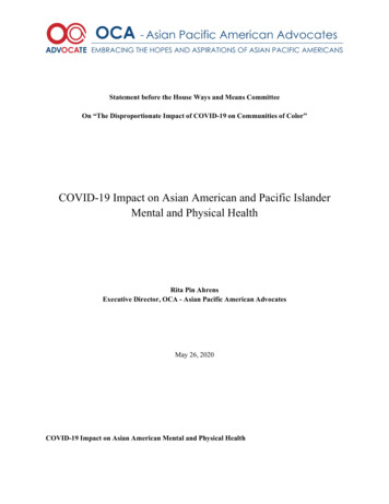
Independent stateNational boundaryLAOSNational Capital(KEDIRI)Former state/chiefdomOther cityltownANNAMOther political regionMajor archaeological snePTPathum Thani provinceVolcano5B5uphan Bun provinceMAI.AYEthnic groupoIo200iii200400600 miles400iIiI800 km600For additional details for mainland Southeast Asia north of Malaysia see Fig. 18.1.0 0PACIFICPAAACEL ' ISLANDS' ''.(}! Sou t h.f/ -4fChi n aIIdlIlIIlInSeaSeaSPAATLYISLANDS : o 10'g t:IjO'.,' .8"00 I A No108"INSET 1FIG.100'INSET 2110'16.1. REFERENCE MAP FOR THE STUDY OF INDIGENOUS SOUTHEAST ASIAN CARTOGRAPHY." 'D.
692land from 1891 until his retirement in 1910. Many of themaps he collected were Shan maps, made at his behest.Though these maps were from an area of Burma, theyrelate to a culture that is more Thai than Burmese. Neither Burney nor Scott is known to have written aboutthe maps he collected (though both wrote extensivelyabout other matters), and it was not until about 197985 that any sort of public record of their coverage wasmade. This was thanks to the efforts of Patricia Herbert,who cataloged the Burney papers at the Library of theRoyal Commonwealth Society, and to Andrew Dalby andShan historian Sao Saimong Mangrai, who performed asimilar service for the Scott Collection at Cambridge University.9Following Burmese independence, historians withinthat country also demonstrated an interest in its cartographic heritage. Many maps that might otherwise havebeen consigned to oblivion were collected and preservedby members of the Burmese Historical Commission, mostnotably U Maung Maung Tin and Than Tun. But littleof what they found, as far as I know, has been discussedin published accounts. A noteworthy exception is thelucid exposition of King Mindon Min's plan of about1850 for the development of a new Burmese capital atMandalay.lO Whether other such discussions exist in Burmese is not known.Premodern indigenous Thai maps are much fewer thanfor either Burma or Vietnam. Nevertheless, several valuable works on that limited corpus have appeared: a briefstudy by Wenk on the illustrated geographic portion ofthe Traibhumikatha (Story of three worlds), a Thai cosmological text (Thai Trai phum); an exceptionally thorough study by Kennedy of an early nineteenth-centurymilitary map of northeastern Thailand; and an outlinehistory by Freitag of Thai cartography of both the premodern and modern periods. 11 This last work is the onlystudy of any country of Southeast Asia by a historian ofcartography that has any claim to comprehensiveness,apart from Quirino's study of Philippine cartography,which, in the absence of old indigenous maps, relatesentirely to foreign (either Chinese or European) and modern works. 12Surviving maps of the Malay world are very few, andthe literature relating to them is meager. Not countingdiscussions of cosmographic works, to be consideredbelow, only a few maps have been the subject of scholarlyarticles. Of these, I have already noted the commentariesof Holle and Kusmiadi on a supposed sixteenth-centuryJavanese map. One other undated Javanese, or possiblyBalinese, map that has been the object of some studyappears on a batik shawl that is described in a 1933 catalog. 13 From the aboriginal Sakai tribe of peninsularMalaysia come a number of bamboo artifacts inscribedwith diverse and enigmatic drawings that have been inter-Cartography in Southeast Asiapreted as locality maps and explained in considerabledetail by the ethnographer Hrolf Vaughan Stevens. 14Apart from these works, there are published commentaries on maps that are either copied from or stronglyinfluenced by European prototypes. The former includeseveral early nineteenth-century Buginese sea charts ofthe greater part of Southeast Asia that are discussed atconsiderable length in an exemplary study by Le Roux.The latter, a supposed early eighteenth-century map ofthe Malay Peninsula, was described by Phillimore inImago Mundi. 1sThis list of sources, although not exhaustive, doescover the principal known published references to surviving indigenous Southeast Asian maps that are notessentially cosmographic in nature. Asian cosmography,however, is a subject to which historians of cartographyhave as yet given scant attention. For commentaries on9. Parts of Herbert's catalog appear as an appendix to the work byBlackmore, Burney Parabaiks (note 8); but this appendix mentions nomaps, in contrast to an unpublished portion of the catalog available atthe Royal Commonwealth Society in London. The paper by Dalby andSaimong, "Shan and Burmese Manuscript Maps" (note 8), providesdescriptions of the maps in the Scott Collection. I extend my gratitudeto both Herbert and Dalby for their exceptional kindness in helpingme locate and understand Burmese and Shan maps. The personal introductions Herbert arranged were of invaluable assistance.10. U Maung Maung Tin and Thomas Owen Morris, "Mindon Min'sDevelopment Plan for the Mandalay Area," Journal of the BurmaResearch Society 49, no. 1 (1966): 29-34.11. Klaus Wenk, "Zu einer 'Landkarte' Sued- und Ostasiens," inFelicitation Volumes of Southeast-Asian Studies Presented to His H ighness Prince Dhaninivat Kromamun Bidyalabh Bridhyakorn . on theOccasion of His Eightieth Birthday, 2 vols. (Bangkok: Siam Society,1965),1:119-22 with 1 pI.; Victor Kennedy, "An Indigenous Early Nineteenth Century Map of Central and Northeast Thailand," in In Memoriam Phya Anuman Rajadhon: Contributions in Memory of the LatePresident of the Siam Society, ed. Tej Bunnag and Michael Smithies(Bangkok: Siam Society, 1970), 315-48 and 11 appended maps; andUlrich Freitag, "Geschichte der Kartographie von Thailand," in Forschungsbeitriige zur Landeskunde Sud- und Sudostasiens, FestschriftfOr Harald Uhlig zu seinem 60. Geburtstag, vol. 1, ed. E. Meynen andE. Plewe (Wiesbaden: Franz Steiner, 1982), 213-32; see also KlausWenk, Thailiindische Miniaturmalereien nach einer Handschrift derindischen Kunstabteilung der Staatlichen Museen Berlin (Wiesbaden:Franz Steiner, 1965), 64 and pI. XI.12. Carlos Quirino, Philippine Cartography (1320-1899), 2d rev. ed.(Amsterdam: Nico Israel, 1963).13. Koninklijk Instituut voor de Tropen, Aanwinsten op ethnografisch en anthropologisch gebied van de Afdeeling Volkenkunde van hetKoloniaal Instituut over 1933, Afdeeling Volkenkunde 6 (Amsterdam,1934), 24-26.14. Hrolf Vaughan Stevens, "Die Zaubermuster der Orang hutan,"pt. 2, "Die 'Toon-tong'-Ceremonie," Zeitschrift fur Ethnologie 26(1894): 141-88 and pis. IX and X.15 C. C. F. M. Le Roux, "Boegineesche zeekaarten van den IndischenArchipel," Tijdschrift van het Koninklijk Nederlandsch Aardrijkskundig Genootschap, 2d ser., 52 (1935): 687-714 and folding map, andReginald Henry Phillimore, "An Early Map of the Malay Peninsula,"Imago Mundi 13 (1956): 175-79.
Introduction to Southeast Asian Cartographyrepresentations of the cosmos, beyond the realm of mortals, we must rely mainly on ethnographers, students ofreligion, and art historians. In the case of Southeast Asia,where all the major religions are exogenous, much of thebasic cosmological research has been done mainly in andon other areas, especially India, the hearth of Hinduismand Buddhism, which jointly held sway in the region formost of its recorded history.16So far as I am aware, the earliest published images ofthe Buddhist cosmos are the facsimiles of Burmese andLaotian representations of the universe that appear inBastian's Ideale Welten (1892).17 A set of more generalized drawings by Bastian attempts to elucidate the majorcomponents of the Hinayana Buddhist cosmos. 18 Atabout the same time, Gerini provided a detailed drawingof the Cakravala, the central portion of the cosmos, asconceived by the Thais and reconstructed (three-dimensionally and on a grand scale) for the performance, overthe period of one week (25 December 1892 to 1 January1893), of the sacred tonsure ceremony.19 Yet anotherseminal work of this period was Temple's Thirty-sevenN ats, which shows the interplay of Burmese spirit worship and popular Buddhism and includes one cosmographic world map.20 Additional illustrated discussionsof Southeast Asian Buddhist cosmographies do notappear, as far as I know, until after World War II. Someof these will be introduced in their appropriate contextsin the following chapter.Attempts to understand the cosmological systems ofthe numerous tribal peoples of Southeast Asia are relatively recent. Although many anthropological studies ofthe postcolonial period address the subject, and someeven make it a dominant concern, reproductions of visualrepresentations of major portions of the cosmos, as conceived by animistic tribal people, are not abundant. Particularly noteworthy in this regard, however, is thepioneering work of the Swiss missionary-ethnographerHans Scharer, who first brought to light maps associatedwith the mortuary cult of the Ngaju Dayaks of interiorBorneo. 21 Other scholars have since shed additional lighton similar practices among other Dayak groups; but forno other part of the Malay Archipelago have cosmographic artifacts emerged that one would clearly identifyas maps. Anthropologists have, however, imputed cosmographic significance to the spatial arrangements ofhouses, villages, and even petty states in various localitiesof Indonesia. 22THE NATURE OF THE SOUTHEAST ASIANCARTOGRAPHIC CORPUSWe do not know when maps were first made in SoutheastAsia. No early cave paintings or other prehistoric archaeological remains that include maplike elements have693come to light in the region. Nor do we know of anyancient historical texts that make explicit references towhat one might consider a map, even though many Hinduand Buddhist texts rich in cosmographic and geographicdetail-the Indian epics, the Puranas, the Jataka tales, andso forth-have become a part of the literary heritage ofthe Indianized portions of Southeast Asia. Similarly, I amunaware of any wholly indigenous literature of the periodbefore the advent of Europeans that makes reference tomaps. Although it might not seem unreasonable toassume that early Indian migrants to Southeast Asia, dating as far back as the late first millennium B.C., broughtwith them some of the limited cartographic competencethat then existed in their home countries, there is neithertangible nor textual evidence to support such a supposition. Nor do we have firm evidence of the transfer ofcartographic skills from China to the lands to its south,not even during the Mongol expansion into those twoareas in the thirteenth century. It may also seem reasonable to suppose that Indonesians, who settled Madagascar about the beginning of the Christian Era and remainedin maritime contact with that island until the fifteenthcentury, must have developed some sort of nautical chartsas navigational aids; but again no supporting evidencesurvives.One must turn then to architecture for the first unequivocal visual representations of cosmographic ideas inSoutheast Asia. Royal Hindu temples, essential symbolsof political power in the many Indianized states of theregion, were centered on shrines representing MountMeru, the cosmic axis mundi. The earliest such temples16. For research on South Asian cosmology, see Joseph E. Schwartzberg, "Cosmographical Mapping," in The History of Cartography, ed.J. B. Harley and David Woodward (Chicago: University of ChicagoPress, 1987-), vol. 2.1 (1992), 332-87.17. Adolf Bastian, Ideale Welten nach uranographischen Provinzenin Wort und Bild: Ethnologische Zeit- und Streitfragen, nach Gesichtspunkten der indischen V olkerkunde, 3 vols. (Berlin: Emil Felber, 1892),vols. 1 and 3.18. Adolf Bastian, "Graphische Darstellung des buddhistischen Weltsystems," Verhandlungen der Berliner Gesellschaft fur Anthropologie,Ethnologie und Urgeschichte, 1894, 203-15 and pIs. 3-7, in Zeitschriftfur Ethnologie, vol. 26.19. Gerolamo E. Gerini, Cha!akantamangala; or, The Tonsure Ceremony as Performed in Siam (Bangkok: Siam Society, 1976; first published in 1895), diagram 1 (facing p. 136).20. Richard C. Temple, The Thirty-seven Nats: A Phase of SpiritWorship Prevailing in Burma (London: W. Griggs, 1906); world mapfacing 8. There is also a new edition with an essay and bibliographyby Patricia M. Herbert (London: P. Strachan, 1991).21. Hans Scharer, Die Gottesidee der Ngadju Dajak in Sud-Borneo(Leiden: E. J. Brill, 1946), English translation, Ngaju Religion: The Conception of God among a South Borneo People, trans. Rodney Needham(The Hague: Martinus Nijhoff, 1963); and idem, "Die Vorstellungender Ober- und Unterwelt bei den Ngadju Dajak von Sud-Borneo," Cultureellndie 4 (1942): 73-81.22. See the discussion below, pp. 739-40.
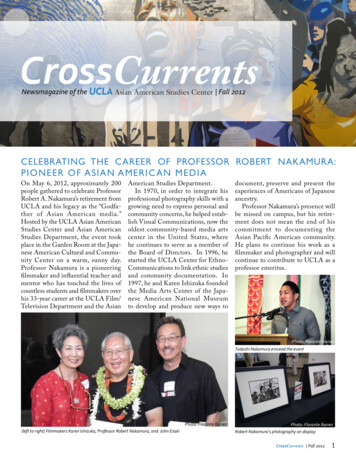
I\rUPyad haait;;-u.::.-.! ttJ-----j ------ JKam:dhalU: FIG. 16.2. BOROBUDUR. This great Mahayana Buddhist "temple mountain" was constructed in central Java. It comprises fivemore or less square terraces of gradually diminishing size overa large square plinth, surmounted in turn by three diminishingcircular terraces surrounding a large circular stupa. The entireedifice symbolizes the unity of the cosmos, with the Buddhisttransition from the low states of reality toward the base,through various increasingly exalted psychological states, to theblissful condition of enlightenment at the summit. Carvings instone on the walls of each terrace depict the acts that contributeto or detract from merit at various stages of existence. At thelower levels the scenes represent mundane subjects, and athigher levels the subject matter is increasingly metaphysical. Ofa design inspired by Indian stupas, Borobudur was the likelysource of inspiration for the numerous temple mountains builtat Angkor.Photograph courtesy of Robert Harding Picture Library Limited, London. Drawing after Philip Rawson, The Art of Southeast Asia (London: Thames and Hudson, 1967), 224-25.
Introduction to Southeast Asian Cartography695FIG.16.3. ANGKOR WAT. An enormous structure (1,550 mlong x 1,400 m wide), this essentially Vaishnavite Hindu "temple mountain," built in the first half of the twelfth century, wasone among many constructed by Khmer monarchs to symbolizetheir divinity and universal dominion. Its central tower represents Mount Meru and its surrounding moat the encompassingocean. More than a mile of sculpted bas-relief adorns the friezesat various levels of the temple and illustrates a wide range ofmundane and mythological themes, prominent among which isthat of the god-king as the giver of water and source of fertility.The Hindu cosmogonic myth of serpents wrapped aroundMount Meru and used as ropes to churn the world ocean isalso rendered in massive sculpture.From George Groslier, Angkor, 2d ed. (Paris: Librairie Renouard, 1931), fig. 80.surviving are in Java and date from the seventh century.Buddhist temples, incorporating similar cosmologicalprinciples, go back at least as far as the late eighth century. Borobudur, the greatest of all Javanese Buddhisttemples (fig. 16.2), was constructed about 800, and theLara Janggrang Temple, the most renowned of JavaneseHindu edifices, was built at Prambanan about 900-930.On the mainland, shortly thereafter, the foundations werelaid for the magnificent temple complex at Angkor. Thereeach successive Khmer monarch built one or more of hisown temple mountains, culminating in the constructionof the Vaishnavite Angkor Wat (fig. 16.3) in the first halfof the twelfth century and the even more extensiveMahayana Buddhist Angkor Thorn and Bayon assemblages (ca. 1200). Thai conquest of the Khmers in thelate thirteenth century, the area's conversion to HinayanaBuddhism, already dominant in lands farther to the west,and other factors brought an end to such grandiose proj-ects. But whether Hindu, Mahayana Buddhist, or Hinayana Buddhist (the traditions were often blended),Southeast Asian religious architecture retained a strongcosmographic symbolism. Among Hinayana Buddhists,the dominant form became the chetiya, a variant of theSouth Asian stupa, also symbolizing Mount Meru. Sinceliterature on the subject is voluminous and readily accessible, there is little point in trying to summarize here thedevelopment of Southeast Asian architecture, even inregard to its strictly cosmographic aspects.Some architectural assemblages were intended asreconstructions of the sacred geography of the group ofsites in and around Bodh Gaya in northeastern India,where the Buddha attained enlightenment. 23 At least fourattempts were made to recreate, more or less faithfully,23. See, for example, Donald M. Stadtner, "King Dhammaceti'sPegu," Orientations 37, no. 2 (1990): 53-60.
Cartography in Southeast Asia696FIG. 16.4. BAS-RELIEF PLAN OF A JAVANESE TEMPLECOMPOUND. This plan, sculpted in stone, appears on thenorth wall of Jawi Temple, constructed in central Java in thelate thirteenth century.Size of the bas-relief: ca. 30 x 70 em. From Jacques Dumar ay,"Notes d'architecture Javanaise et Khmere," Bulletin de l' EcoleFran aise d'Extreme-Orient 71 (1982): 87-147, esp. pI. 11.the great temple at Bodh Gaya that the Mauryan emperorAsoka is believed to have had built in the third centuryB.C. These include temples built at Pagan and Pegu, inBurma, in the thirteenth and fifteenth centuries, respectively, and two in the northern Thai towns of ChiangMai and Chiang Rai, also built in the fifteenth century.While the chronicles in Thailand are silent aboutwhere Tiloka [the king responsible for building thetwo Thai reconstructions) obtained his temple plans,those in Burma that mention King Dhammacetiya'scopy-built in Pegu at almost the same time as Tiloka's-specifically state that he sent a large group ofartisans to Bodhgaya to make plans and models. 24Apart from their architectonic aspect, temples wereinteresting for their sculptural details and their muralpainting. Much of this painting in relatively recent temples, as I shall note in the next chapter, is itself cosmographic; and it seems virtually certain that a tradition ofsuch painting goes back many centuries. But becausepainting seldom lasts more than a few hundred years, Ican point to no good examples of very old mural cosmographies. 25 Sculptural detail on Southeast Asian temples ranged over a wide variety of themes, both secularand religious. Some bas-reliefs appear to present bird'seye views of scenes including temples, courtyards, villages, cultivated fields, and occasionally streams and othernatural features. In the absence of a systematic inventoryof Southeast Asian temple sculpture, I cannot venture anopinion on the frequency of such maplike images, thoughthey do not appear to have been common. Figures 16.4and 16.5 present examples from late thirteenth- and fourteenth-century Java.The pervasive Buddhist concern with cosmology foundexpression in the illustrations that accompanied literarytexts. One such text, the Traibhumikatha or Trai phum,allegedly adapted from the Sri Lankan Pali canon by theThai king Phra Ruang in 1345, describes in great detailthe structure of the three worlds and thirty-one realmscomposing the universe. Some of the surviving recensions(no complete copy predates the eighteenth century) areprofusely illustrated. In fact the illustrations may take upfar more space than the accompanying text. Whether theoriginal and other early recensions were similarly adornedis not known, but it is reasonable to suppose that somewere. 26Cosmographies were also prepared in other forms: inpaintings, on palm-leaf manuscripts, as three-dimensionalsculptures, as decorations on furniture, and presumably,if contemporary practice in South Asia may be taken asa guide, in various types of folk art. Gates and othertemple stru
Southeast Asia, as here defined, shows relatively little unity with regard to the surviving corpus ofits premodern indigenous maps. To treat the entire region together in this history is, to a considerable extent, an editorial con venience that reflects the division of labor among the contributors to this work. There are, to be sure, certain