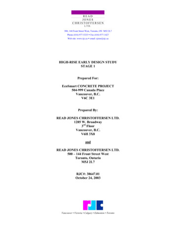
Transcription
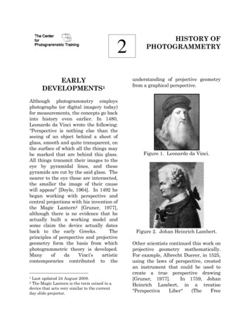
2EARLYDEVELOPMENTS1Although photogrammetry employsphotographs (or digital imagery today)for measurements, the concepts go backinto history even earlier. In 1480,Leonardo da Vinci wrote the following:“Perspective is nothing else than theseeing of an object behind a sheet ofglass, smooth and quite transparent, onthe surface of which all the things maybe marked that are behind this glass.All things transmit their images to theeye by pyramidal lines, and thesepyramids are cut by the said glass. Thenearer to the eye these are intersected,the smaller the image of their causewill appear” [Doyle, 1964]. In 1492 hebegan working with perspective andcentral projections with his invention ofthe Magic Lantern2 [Gruner, 1977],although there is no evidence that heactually built a working model andsome claim the device actually datesback to the early Greeks.Theprinciples of perspective and projectivegeometry form the basis from whichphotogrammetric theory is developed.ManyofdaVinci’sartisticcontemporaries contributed to theLast updated 24 August 2008.The Magic Lantern is the term coined to adevice that acts very similar to the currentday slide projector.12HISTORY OFPHOTOGRAMMETRYunderstanding of projective geometryfrom a graphical perspective.Figure 1. Leonardo da Vinci.Figure 2. Johan Heinrich Lambert.Other scientists continued this work onprojective geometry mathematically.For example, Albrecht Duerer, in 1525,using the laws of perspective, createdan instrument that could be used tocreate a true perspective drawing[Gruner, 1977].In 1759, JohanHeinrich Lambert, in a treatise"PerspectivaLiber"(TheFree
perspective image using space resectionto find a point in space from which apicture is made.The relationshipbetween projective geometry andphotogrammetry was first developed byR. Sturms and Guido Hauck inGermany in 1883. [Doyle, 1964]The first photograph was obtained byJoseph Nicephone Niépce (1765-1833).The positive image Niépce required aneight-hour exposure. In 1837, JacquesMandé Daguerre obtained the first"practical" photograph using a processcalled the Daguerreotype. Around 1840,the French geodesist DominiqueFrançois Jean Arago began to advocatethe use of "photogrammetry", using thedaguerreotype, in front of the FrenchArts and Science Academy.Figure 3. Albrecht DuererFigure 5. J. N. Niepce.Figure 4. Woodcut by Duerer TheDraughtsman And The Lute from hisbook: 'Treatise on Mensuration withthe Compass and Ruler in Lines,Planes, and Whole Bodies' (1525)Center for Photogrammetric TrainingFigure 6. Jacques Daguerre.History of PhotogrammetryPage 2
DEVELOPMENT CYCLESFigure 7. Photogrammetricperspective by Hauck.The developments in photogrammetry,from around 1850, have followed fourdevelopment cycles [Konecny, 1985].Each of these periods extended aboutfifty years. These cycles include:a)b)c)Figure 8. Dominique François JeanArago.Center for Photogrammetric Trainingd)Plane table photogrammetry,from about 1850 to 1900,Analog photogrammetry, fromabout 1900 to 1960,Analyticalphotogrammetry,from about 1960 to present, andDigital photogrammetry, whichis just beginning to be a presenceinthephotogrammetricindustry.History of PhotogrammetryPage 3
Konency's [1985] development cyclesare based upon the economic theory ofKondratjew. Before each cycle, a basicinvention is present. The first practicalinstrumentation follows in 10-15 years.Anywhere from 20-25 years after theinvention the new technology begins tobe used in normal practice. Thistechnology is then utilized for 25 yearsafter which it shares the market withthe new developments from the nextcycle for an additional 25 years or so.Collier [2002] uses a differentapproach, dividing data collectiondevelopments in topographic mappinginto 4 phases. The first phase wasprior to World War I. This segment isbest described by individualizedexperimentation into new techniquesbut with little change in the mapmaking process. He also characterizedthis period as one of “considerablecross-national cooperation”. The secondphase comprises the period of WorldWar I. Experimentation gave way todevelopment of simple map makingtechniques geared towards mappingneeds of the military.The 1920scomprise phase three. We see theintroduction of the airplane as well asconsiderable technological advances ininstrumentation.Mapping focuschanges from military uses to civilianneeds. As Collier points out, this periodis also characterized as nationalisticwith little international cooperation.Finally, phase four saw the beginningsoflarge-scalecivilmapping.Photogrammetry matured from anCenter for Photogrammetric Trainingexperimental map making technologyinto a proven technique for accuratemaps. While much has changed in thetechnology since the 1930s, Collierwould probably argue that these arefurther maturation of what developedin the 1930s. He argues that theintroduction of the slotted template andmultiplex plotter changed the face oftopographic mapping.As Collier [2002] maintains, the statusof topographic mapping was poor priorto 1900. The Ordnance Survey inGreat Britain did have completetopographic map coverage of theircountry at a scale of 1:10,000. Belgiumwas similarly mapped that the samescale. Other countries had mixtures ofscales and incomplete coverages. In theUnited States, only about 26% of thecountry had topographic coverage. Fortowns and special projects the mapscales were either 1:31,680 or 1:24,000while settled rural areas had coverageat a scale of 1:62,500. The remainingportions of the U.S. with topographicmap coverage had maps at a scale of1:125,000 or 1:250,000. In Canada thesituation was even worse.Maps are critical elements for nationaldevelopment. When the East IndiaCompany obtained control of India, oneof the first orders of business was tosurvey the country [Collier, 2002].Much of this need was driven by fiscalneeds, although these topographicmaps were used for other purposes. Asthe English Empire expanded intoAfrica, the necessity of maps becameHistory of PhotogrammetryPage 4
quickly apparent.A report of theColonial Survey Committee identifiedthe importance of maps [from Collier,2002]:The purposes for which maps arerequired in the administration ofacountry(especiallyanundeveloped country such as aprotectorate in Tropical Africa)are many and varied. Maps arenecessary to define the exactlimits of national territory, toshow the areas and villagesunder the rule of native chiefs,they are essential for landregistration and settlement, forthe allotment of mining andforest concessions, and for theorganizationofinternalcommunications.Of theirnecessity in was the experiencesof the army in South Africaafford an eloquent testimony;and even the conduct of a “smallwar” or a police expedition ismuch simplified by the existenceof reliable maps of the scene ofoperation.Figure 9. Aimé Laussedat medal.While there are some noted exceptionsas we will see later, the almostuniversalmethodofcreatingtopographic maps in 1900 was byground survey.Indeed, as Collier[2002] identifies, mapping techniquesin 1900 were almost the same as theywere in 1800.Instruments wererefinedandmoreaccuratelymanufactured, but the techniques werethe same for all intents and purposes.Center for Photogrammetric TrainingPLANE TABLEPHOTOGRAMMETRYIn 1849, Aimé Laussedat (April 19,1819 - March 18, 1907) was the firstperson to use terrestrial photographsfor topographic map compilation. He isreferred to as the "Father ofPhotogrammetry".TheprocessLaussedat used was called iconometry[icon (Greek) meaning image, -metry(Greek) which is the art, process, orscience of measuring]. In 1858, heexperimented with aerial photographysupported by a string of kites butabandoned it a couple of years later. In1862, Laussedat's use of photographyfor mapping was officially accepted bythe Science Academy in Madrid. Healso tried balloon photography and isthe first person to have captured animage from balloons, but deserted itbecause of the difficulty of obtaining asufficient number of photographs tocover all of the area from one airstation [Birdseye, 1940]. At the ownHistory of PhotogrammetryPage 5
phototheodolite and his plan of Parisderived from his photographic surveys.These maps were comparable to earliermaps compiled from conventional fieldsurveys which showed that this newtechnology could be used for mapping.Plane table photogrammetry is anextension of the conventional planetable surveying [Konecny, 1985]. Eachexposure station was determined byresection and plotted on the planetable. The exposed photos wereoriented on the plane table and thedirections to the different objects weretransferred onto the map sheets.Figure 10. Nadar obtainingphotography from a balloon.With the advent of photography andthe ability to make exposures from theair, it was soon found that there weremilitary applications to this technology.In 1855, Nadar (Gaspard FelixCenter for Photogrammetric TrainingTournachon) used a balloon at 80meters to obtain the first aerialphotograph. In 1859 the EmperorNapoleon ordered Nadir to obtainreconnaissancephotographyinpreparation of the Battle of Solferino.In the Franco-Prussian War during the1870s, the Prussian army installed aphoto field detachment to obtainstereophotos, most notably of thefortification of Strasbourg [Gruner,1977].Paulo Ignazio Pietro Porro (November25, 1801 – October 8, 1875) was anItalian geodesist and optical engineer.As a geodesist, he invented the firsttacheometer (his instrument was calleda tachymeter) in 1839. In 1847 he wasable to improve image quality of a lenssystem all the way to the edges byusingthreeasymmetricallenselements.He also developed anerecting lens imaging system in 1854.Porro developed a panoramic camera in1858 that was equipped with a sightingtelescope, compass, and level.Theimage was recorded on sensitized papermounted on a cylinder [Birdseye, 1940].In1865hedesignedthephotogoniometer. This development issignificant in photogrammetry becauseof its application in removing lensdistortion. His approach was to look atthe image with a telescope through thecamera lens. This concept was alsoindependently considered by CarlKoppe (1884-1910). Therefore, thisconcept is called the Porro-KoppePrinciple.History of PhotogrammetryPage 6
actually used these cameras fortopographic surveys.Moessard, in1884,notonlydevelopeda“cylindrographe” but also used it formapping purposes.According toBirdseye,the“instrumentwasequipped with a sighting device whichrotated the lens in a horizontal planeand exposed a strip of film wound on acylinder”.Figure 11. Ignazio PorroIn 1858, the Frenchman Chevallierdeveloped a "photographic plane table"(PlanchettePhotographique).Thiscamera exposed the photo plate in ahorizontal position. The light rays weredeflected at right angles by using aprism attached to the sighting devicethat could be rotated [Birdseye, 1940].In 1885, George Eastman usednitrocellulose as a film base and later(1890) replaced the photographic dryplate for roll film [Gruner, 1977]. F.Stolze discovered the principle of thefloating mark, which is used forstereoscopic measurements.Figure 13. George Eastman.Figure 12. Chevallier's photographicplane table.Birdseye [1940] indicated that whilepioneers were refining panoramicphotography, there was no evidencethat Porro, Chevallier, and othersCenter for Photogrammetric TrainingIn the U.S., James Fairman was issueda patent for an “Apparatus for aerialphotography3” on August 2, 1887. Thisdevice used a camera supported byeither a balloon or a kite with theshutter being operated with a clockmechanism. This was the first aerialphotography captured from a balloon in3Patent No. 367,610History of PhotogrammetryPage 7
the U.S.On December 12, 1893,Cornele B. Adams was given a patentfor his “Method of Photogrammetry4”.His approach was to obtain two aerialphotos of the same area with a camerafrom two positions of a captured balloon[Birdseye, 1940]. Adams also inventedradial line triangulation in an effort tographically solve the principles in planetable photogrammetry to his balloonimagery.photogrammetry, he designed his firstcamera in 1867. This was the firstwide-angle lens used for mapping –105o Pantoshop lens. It was used forthe topographic map of Freyburg,Germany, and the structural drawingof St. Mary’s Church. The camera hasthe following characteristics that arefound in metric cameras [Meyer, 1987,p.184]: Figure 14. Albrecht Meydenbauer[from Meyer, 1987].In 1893, Dr. Albrecht Meydenbauer(April 30, 1834 - November 15, 1921)was the first person to use the term"photogrammetry". He founded theRoyalPrussianPhotogrammetricInstitute and served as its directoruntil 1909.Meydenbauer is known for ng thatcurrent cameras were not suitable for4Patent No. 510,758.Center for Photogrammetric Training“sturdy body,permanently mounted lens,spirit levels for leveling up thecamera,device for aligning the cameraaxis, anddefinition of the image plane bya frame with fiducial marks forthe coordinate axes.”Meydenbauer’smethodofmapcompilation utilized the approach atthat time. The photograph was used tomap the terrain by intersection.Directions from ground control pointswere graphically plotted from theimagery. Conventional surveying wasused to locate the position of thecameras and a few control points in thescene being photographed. Accordingto Meyer [1987], a good draftspersoncouldobtainthephotographiccoordinates using dividers to anaccuracy of about 0.1 mm.Theresulting map would have an accuracyof about 0.2 mm. High accuracy wasachieved in Meydenbauer’s methodsbecause he used a large format size (40cm x 40 cm) and his selection of theratio between the photo scale and mapHistory of PhotogrammetryPage 8
scale, which seldom exceeded a factor of2. In addition, he utilized mirror glassfor the emulsion substrate to maintainthe required film flatness during theexposure.Figure 16.Meydenbauer’s cameradeveloped in 1872 [from Meyer, 1987].ANALOGPHOTOGRAMMETRYFigure 15. Meydenbauer’s principlesof photogrammetry [from Meyer,1987].Meydenbaur continued to work ondifferent camera designs. For example,in 1872 he developed two new camerasusing a smaller 20 cm x 20 cm format.One had a focal length of 12 cm and theother 21 cm. The significance of thiscamera was that the plates werechanged after each exposure. This wasdone using a light-tight container. Tochange the film, the camera wasremoved from the tripod and placed inthe container [Meyer, 1987].Center for Photogrammetric TrainingTwo important developments wererequired to advance photogrammetry .First, stereoscopy was becoming widelyused. Second, the development of theairplane by the Wright brothers in1903. This provided a better cameraplatform than the terrestrial camera.Wilbur Wright has been identified asthe first person to obtain aerial imageryfrom an airplane. He took movies of hisflight in Centoci, Italy, on April 24,1909. The first aerial photographycaptured from a plane for mappingpurposes was done by Captain CesareTardivo for a 1:4,000 mosaic of Bengasi,Italy. He presented this survey in aHistory of PhotogrammetryPage 9
paper delivered at the InternationalSociety of Photogrammetry meeting inVienna on September 25, 1913[Birdseye, 1940].(called the Canadian Grid Method)were employed.In 1888, a singletopographic party of four surveyors,under the chief J. J. McArthur,surveyed around 500 square miles ofthe Canadian Rockies [Birdseye, 1940].Figure 17. Edouard Deville.In Canada, Edouard Deville (February26, 1849 - September 21, 1924), theSurveyor General of the Dominion,invented the first igraph in 1896. While this was thefirst attempt to use stereo overlappingphotos,thecomplexityoftheinstrument resulted in little use.Stereoscopy was achieved through aWheatstone Stereoscope to create thestereomodel. Within the model, Devilleused a tracer point to perform themapping [Gruner, 1977]. He was verysuccessful in the mapping of theCanadian Rocky Mountains and isreferred to as "Canada's Father ofPhotogrammetry". Deville used acamera and theodolite mounted on thesametripod(non-stereoscopicphotography). The theodolite was usedto establish control while the camerawas used for acquiring the photographyfor mapping. In order to transfer theimagery to the map, projective gridsCenter for Photogrammetric TrainingFigure 18. Deville's StereoPlanigraph.Figure 19.Illustration of theCanadian Grid Method used byDeville.The early pioneers like Meydenbauradvanced the ideas that werepresented by Lausseat [Collier, 2002].Planimetric detail and contours werederived suing graphical methodsdirectly from the photographs. Theprocesses were difficult to perform andtedious.Thus,eventhoughphotogrammetry was being used formapping purposes, they primarilyHistory of PhotogrammetryPage 10
found use in situations whereconventional plane table mapping waseither too difficult or impracticable touse.presented a method of maintaining asustained focus in rectification ofphotographs that is called theScheimpflug Condition. In order tohave sharp focus when the negativeand easel (positive) planes are notparallel, the negative plane, easel planeand lens plane (plane perpendicular tothe optical axis) must intersect alongoneline.Thisperspectivetransformation was used in thedevelopment of the “Perspektograph” in1903.Scheimpflug introduced theconcept of radial triangulation and issometimes considered the initiator ofaerial photogrammetry since he wasthe first to successfully use aerialphotographs for practical mapping5.Figure 20. Transporting the surveycamera to its next location in theRockies.The U.S. Geological Survey began touse photogrammetry for topographicmapping in 1904. C. W. Wright and F.E. Wright took photos from the groundusing a panoramic camera in theirsurvey in Alaska.They used acommercial camera, modified byadding level bubbles and internalscales within the camera.Theodor Scheimpflug (October 7, 1865– August 22, 1911), an Austrian,developed the theory of the doubleprojector, which offered direct viewingof the projected images. He alsoCenter for Photogrammetric TrainingFigure 21. Theodor Scheimpflug.AccordingtoBirdseye[1940],Scheimpflug also worked with kites butmoved to balloons and later to dirigibleballoons.While Laussedat at/Luftbildarchiv/wgv/intro.htm.History of PhotogrammetryPage 11
Scheimpflug developed a multi-lenscamera in 1900 that consisted of acentral vertical lens surrounded byseven oblique lenses. This gave himsome very wide angle compositephotography with which to work. Oneof the issues with balloons is the effectof wind on the flight line. The dirigibleballoon gave the pilot better controlover the flight direction. This led to theexpansion of aerial photogrammetry inEurope.described the principles of moderndouble-image photogrammetry and themethodology of relative and absoluteorientation. In addition, he introducedthe necessity of redundant rays torecreate the proper geometry and usedleast squares theory to describe therelationship of the vectors betweencorresponding rays [Doyle 1964].In 1901, Dr. Carl Pulfrich (September24, 1858 - August 12, 1929), a Germanphysicist,designedthefirststereocomparator employing x and ycoordinate scales and presented theresults at the 73rd Conference ofNatural Science and Physicians inHamburg [Doyle, 1964]. This was thefirstphotogrammetricinstrumentmanufactured by Zeiss. Pulfrich issometimes referred to as the "Father ofStereophotogrammetry".Figure 22. Sebastian FinsterwalderBeginning in 1899, the GermanSebastian Finsterwalder began topublishpapersonanalyticalphotogrammetry. When studying theresection of single and double points inspace, he showed the existence of acriticalsurfaceforsingle-pointresection. Using vector terminology,Finsterwalder showed the analyticalconditions that must be met for rays tointersect. In 1899, Finsterwalder6The title of the paper was "Die geometrischenGrundlagen der Photogrammetrie"(Fundamental Geometry of Photogrammetry).6Center for Photogrammetric TrainingFigure 23. Dr. Carl Pulfrich.What was remarkable about Pulfrichwas his research on stereoscopy andstereoscopic instrumentation despitethe fact that he had no vision in his lefteye.One of the unique opticalHistory of PhotogrammetryPage 12
phenomenon, called the Pulfrich effect7,deals with the apparent stereo effectthat photogrammetrists first noticedwhen rapid movements of the platedcontaining the imagery on thestereoautograph. Believing it was adesign flaw in the instrument, Zeissassigned two individuals, Franke (anengineer) and F. Fertsch (a technician)to determine the effect. Fertsch foundthat this apparent stereo effect was dueto the difference in brightness by thetwo eyes [Christianson and Hofstetter,1972].January 19, 1948), from South Africa,independently developed a similarstereocomparator. The main differenceis that Fourcade utilized grid platesinstead of x and y coordinates. He wasalso the first to discuss the need forreseau in a surveying camera for usewith the measuring stereoscope.Becauseoftheindependentdevelopment, many refer to thestereocomparator as the PulfrichFourcade stereocomparator.At about the same time, Dr. HenryGeorge Fourcade8 (July 8, 1865 7The Pulfrich effect is often described interms of a pendulum experiment.Forexample, take a pair of sunglasses and takethe lens out of one of the sides. Then, fixateon the pendulum with one eye looking througha darkened glass. Perception through thedark glass is slightly slower thus it wouldappear that the objects are in differentpositions yielding a three-dimensional effect.8 There has been a lot of debate over the yearsas to whether Pulfrich or Fourcade developedthe concept of stereophogrammetry.Thedebate stems from the fact that Pulfrichpresented his ideas at a meeting of the“Naturforscher” on September 23, 1901 inHamburg [Atkinson, 1980]. The title of mmten stereoskopischen Komparator”.On October 2, 1901, Fourcade presented apaper in Cape Town, South Africa, at theSouth African Philosophical Society [Adams,1975; Atkinson, 1980]. His paper was titled“On a stereoscopic method of photographicsurveying”. Pulfrich’s paper was kunde in March, May andCenter for Photogrammetric TrainingFigure 24. Dr. Henry GeorgeFourcade.Collier [2002] indicates that the twoinstruments were capable of makingaccurate stereoscopic measurements.They also required a lot of interpolationof the measurements because the panAugust 1902. Fourcade’s paper was publishedin the Transactions of the South AfricanPhilosophical Society in 1901 and also inNature in 1902. The noted photogrammetristOtto von Gruber identifies Pulfrich as thedeveloper of stereophotogrammetry usingFourcade’s article in Nature as proof thePulfrich was first [Collier, 2002].History of PhotogrammetryPage 13
eocomparator was used in the Tyrolmountain region were conventionalsurveying mapping techniques weredangerous and difficult. In general, thephotogrammetric approach was stillconsidered to not be cost effective.In Germany, Eduard von Orel(November 5, 1877 - October 24, 1941),in1908,developedthefirststereoautograph [Collier, 2002]. Thisplotter was significant because itsconstruction principles made terrestrialphotogrammetrypracticalinmountainous areas. It allowed theoperator to trace elevation contoursdirectly. The first prototype, using thePulfrich stereocomparator, was built bythe Zeiss Works and employed thegeometrical linkage referred to as the“Zeiss parallelogram”. The "Orel-ZeissStereoautograph", developed by Pfeifferand Bauersfeld provided continuousoperation without the need forcomputations required of other plotters.W. Bauersfeld, the chief engineer atZeiss Works, produced the firststereoplanigraph, which is a universaldirect projection stereo instrument.Numerous other individuals yandinstrumentation. These include MaxGasser who built a double projectionplotter for vertical photography (this isthe forerunner of the Multiplex plotter)and the Italian Umberto Nistri (1895 1962) who created a double projectionCenter for Photogrammetric ure 25. Eduard von Orel.Figure 26. Max Gasser.Frederick Vivian Thompson alsodeveloped his stereoplotter in 1908.Collier [2002] indicates that both theThompson and von Orel instrumentswere capable of plotting plan andcontours from terrestrial photographs.The von Orel Autostereograph wasembraced by the MilitärgeographischeInstitut for mapping of Tyrol.Thompson’s stereoplotter received weakacceptance in Great Britain, although itwas employed by the Survey of Indiafor the Karakorum Range mapping.Both plotters suffered from the factHistory of PhotogrammetryPage 14
Figure 27. von Orel's patent for Stereoisohypsograph.that they could not be adapted lanarCenter for Photogrammetric Trainingphotography, a situation that rarelyexisted in aerial photography.History of PhotogrammetryPage 15
ProfessorReinhardHugershoff(October 1882 - February 1941) was asurveyor and photogrammetrist whocontributed much to the development ofsurveyingandmappinginstrumentation. He created the firstanalog plotter in 1921 called theHugershoff Autocartograph. It was avery complex mechanical plotter thatincorporated two photogoniometers.The instrument could be used to mapboth planimetric features and contours.It was universal in that it could be usedfor terrestrial, vertical aerial, oblique,and convergent photography. He alsodeveloped an aerial camera utilizingglass plates that was used to obtainoblique photography by hand or byattaching the camera on the side of theaircraft. When cameras began to beemployed through a hole in thefuselage, Hugershoff developed a ringmount that could be corrected for drift(Gruner, 1971).Hugershoff also developed a projectionplotter where the imagery wasprojected from below on a light table.Stereoscopy was achieved with a mirrorstereoscope.Many of Hugershoff’'sinstruments were used in majorengineering projects. For example, hedeveloped a universal phototheodolitethat was used in the mapping of theHoover dam site. This instrument wasrugged while still maintaining thehighest possible accuracy. It consistedof an eyepiece that was attached to thefocal plane thereby making the cameraa transit telescope. In an attempt tosolve the problems of size in hisautocartograph, Hugershoff developedthe Aerocartograph in 1926.Thisinstrument used space rods instead ofthe complex mechanical system used inhis earlier instrument. It also had thecapability of changing the optical pathallowing the operator to view the leftphotograph with the right eye and rightphotography with the left eye. Thisgave the photogrammetrist the abilityto perform analog aerotriangulation(Gruner, 1971).Figure 28. Professor ReinhardHugershoff.Figure 29. HugershoffAutocartograph.Center for Photogrammetric TrainingHistory of PhotogrammetryPage 16
stereocomparator. These are just a fewof the developments attributed toReinhard Hugershoff. Later in life weworked with Zeiss Works in developingother photogrammetric equipment(Gruner, 1971).Figure 30. Hugershoff''s projectiontype Aerosimplex plotter.Figure 32. Stereocomparatordeveloped by Hugershoff.Figure 31. Phototheodolite developedby Hugershoff.One of the unique instrumentsdeveloped by Prof. Hugershoff was thestereocomparator. It utilized a singlelight source and single measuringmark. The photographs were moved inX and Y tracks for the measurementprocess.This design was thepredecessortotheZeissPSKCenter for Photogrammetric TrainingFigure 33. Aerocartograph taken in1926 in Berlin during the y of PhotogrammetryPage 17
Otto von Gruber (August 9, 1884 - May3, 1942) derived, in 1924, the projectiveequations and their differentials, whicharefundamentaltoanalyticalphotogrammetry. At the time of thisdevelopment, the process was verycomplex and cumbersome. Therefore,von Gruber is credited with saying that“the calculation of resection in space,either by the direct or differentialmethod, is merely waste of time and isof minor practical importance” [Doyle,1964].His method of relativeorientation of a stereoplotter makes theprocess of orientation easier andquicker. This procedure is still in usetoday and the six model points whereparallax is cleared in the model areoften referred to as the von Gruberpoints.orientation, intersection, rectification,and control extension using directioncosines. There are two main criticismsof Church’s approach to analyticalphotogrammetry.His approach isbased on unique solutions were therewere no redundant control. Hence, onebad control point would invalidate all ofthesubsequentcalculations.Additionally, he never performed anyerror analysis to his procedure.Because of this, problems occurred withrealphotography[Doyle,1964].Church, a professor at SyracuseUniversity and one of the foundingmembers of the American Society ofPhotogrammetry, is referred to as the"American Father of Photogrammetry"[Quinn, 1975].Figure 35. Professor Earl Church.Figure 34. Otto von GruberIn a similar vein, Earl Church (August11, 1890 - May 11, 1956) alsocontributed to the theory of analyticalphotogrammetry. He developed theanalytical solutions to space resection,Center for Photogrammetric TrainingDr. Bertil Hallert from Sweden is bestknown for his investigation into errors,stereoplotter orientation procedures,and standards for plotter calibration[Gruner, 1977].History of PhotogrammetryPage 18
During the early part of the twentiethcent
photography from a balloon. With the advent of photography and the ability to make exposures from the air, it was soon found that there were military applications to this technology. In 1855, Nadar (Gaspard Felix Tournachon) used a balloon at 80-meters to obtain the first aerial photogr