Transcription
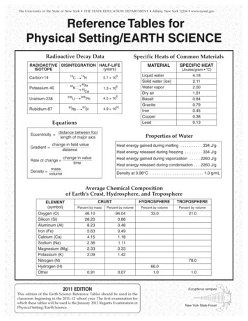
The University of the State of New York THE STATE EDUCATION DEPARTMENT Albany, New York 12234 www.nysed.govReference Tables forPhysical Setting/EARTH SCIENCERadioactive Decay DataSpecific Heats of Common MaterialsRADIOACTIVE DISINTEGRATION 145.7 10N40KAr91.3 1040CaUranium-238238206Rubidium-878787URb9Pb4.5 10Sr4.9 1010EquationsEccentricity Gradient distance between focilength of major axisSPECIFIC HEAT(Joules/gram C)Liquid waterSolid water (ice)Water vaporDry 0.790.450.380.13Properties of Waterchange in field valuedistanceRate of change MATERIALHeat energy gained during melting . . . . . . . . . . 334 J/gHeat energy released during freezing . . . . . . . . 334 J/gchange in valuetimeHeat energy gained during vaporization . . . . . 2260 J/gHeat energy released during condensation . . . 2260 J/gmassDensity volumeDensity at 3.98 C . . . . . . . . . . . . . . . . . . . . . . . . 1.0 g/mLAverage Chemical Compositionof Earth’s Crust, Hydrosphere, and TroposphereELEMENT(symbol)Oxygen (O)Silicon (Si)Aluminum (Al)Iron (Fe)Calcium (Ca)Sodium (Na)Magnesium (Mg)Potassium (K)Nitrogen (N)Hydrogen (H)OtherHYDROSPHERETROPOSPHEREPercent by massCRUSTPercent by volumePercent by volumePercent by .480.491.181.110.331.4233.021.078.00.910.072011 EDITIONThis edition of the Earth Science Reference Tables should be used in theclassroom beginning in the 2011–12 school year. The first examination forwhich these tables will be used is the January 2012 Regents Examination inPhysical Setting/Earth Science.66.01.01.0Eurypterus remipesNew York State Fossil
Lake ErieAppGrenville Province(Highlands)atPluea(Key)dsnlapUTug HillPlateaueInternational boundaryState boundaryLandscape region boundarydsAdirondackMountainsLoanwlThe CatskillsencMajor geographic province boundaryAllegheny PlateauErie-Ontario Lowlands(Plains)Lake OntarioSat. LwrInteriorLowlandsGeneralized Landscape Regions of New York StateInterior LowlandsalachianChamplain LowlandsewEn(H glaigh ndlPand rovN020 40 60Kilometers80Miles0 10 20 30 40 50ticnalAtWSNelainPlastCoandsighlaHnoH udsrongtan PtahManHudso nMohawk LowlandsTaconicMountainsNLo ewawlan rkdsincs)Physical Setting/Earth Science Reference Tables — 2011 Edition2E
79 JAMESTOWNERIEBUFFALONIAGARA FALLS78 78 77 SYRACUSElimestones, shales, sandstones, and dolostonesCAMBRIAN and EARLY ORDOVICIAN sandstones and dolostonesmoderately to intensely metamorphosed east of the Hudson RiverCAMBRIAN and ORDOVICIAN (undifferentiated) quartzites, dolostones, marbles, and schistsintensely metamorphosed; includes portions of the Taconic Sequence and Cortlandt ComplexTACONIC SEQUENCE sandstones, shales, and slatesslightly to intensely metamorphosed rocks of CAMBRIAN through MIDDLE ORDOVICIAN agesMIDDLE PROTEROZOIC gneisses, quartzites, and marblesLines are generalized structure trends.MIDDLE PROTEROZOIC anorthositic rocksORDOVICIANCAMBRIAN74 NEW YORKCITY41 RSEYIntensely metamorphosed rocks(regional metamorphism about 1,000 m.y.a.)JE}WNEKINGSTONSLIDE MT.ALBANYR iv e r}Dominantlysedimentaryorigin75 wkMT. MARCY74 Dominantlymetamorphosedrocks}MohaRive r}}UTICAOLD FORGEMASSENAareCRETACEOUS and PLEISTOCENE (Epoch) weakly consolidated to unconsolidated gravels, sands, and claysLATE TRIASSIC and EARLY JURASSIC conglomerates, red sandstones, red shales, basalt, and diabase (Palisades sill)PENNSYLVANIAN and MISSISSIPPIAN conglomerates, sandstones, and shalesDEVONIANlimestones, shales, sandstones, and conglomeratesSILURIAN also contains salt, gypsum, and hematite.SILURIAN76 SusquehannaBINGHAMTONITHACAP E N N S Y L V A N I A77 WATERTOWN76 OSWEGOLAKES44 ELMIRAFINGERROCHESTERLAKE ONTARIOelevation 75 mmodified fromGEOLOGICAL SURVEYNEW YORK STATE MUSEUM198975 lawGEOLOGIC PERIODS AND ERAS IN NEW YORK42 LAKEelevation 175 m43 79 ar a RiveragNiencerivGeneralized Bedrock Geology of New York StateGerveRieenesSt.LawreRR iv e r73 45 PLATTSBURGHAINMPL44 CHA43 0020406020 40 60 80KilometersKilometers80WMilesMiles20 30 40 500 100 2010 3040 5073 30'41 72 SNEATLANTIC OCEANUND40 30'73 DISLANLONGRIVERHEADND SOISLAG73 N41 LO42 LAKERriveondsHuHu ds onVERMONTMASSACHUSETTSPhysical Setting/Earth Science Reference Tables — 2011 EditionCONNECTICUT45 De3Rive r
Surface Ocean CurrentsPhysical Setting/Earth Science Reference Tables — 2011 Edition4
MidEurasianPlateniaoundIthest eeasgthw RidtInduia nSoRidgeaTr ria n ae n chFiji PlatestEaConvergent plate boundary(subduction azcaPlaterSandwichPlateMantlehot spotBouvetHot SpotSt. HelenaHot SpotAfricanPlateEurasianPlateIcelandHot SpotComplex or uncertainplate boundaryScotiaPlateCanaryIslandsHot SpotMidAtlanticRidgeSouthAmericanPlateanibbeCar latePPeGalapagosHot SpotYellowstoneHot SpotCocosPlateEaster IslandHot SpotPacificPlateHawaiiHot SpotSan AndreasFaultJuan deFuca PlateDivergent plate boundary(usually broken by transformfaults along mid-ocean ridges)TasmanHot SpotTo n g aTr e n c hNorth AmericanPlateMid-Atlantic RidgeTectonic PlateshAleutian rm plate boundary(transform fault)NOTE: Not all mantle hot spots, plates, andboundaries are shown.Relative motion atplate boundaryAntarcticPlateSKeyfrican Rifst AEatianabAr latePidgedian Ridge-InPacificRPhysical Setting/Earth Science Reference Tables — 2011 Editionhile Trenu-Cch5
CRock Cycle in Earth’s Crustrnd/onatio ationcpa entom emCRelationship of TransportedParticle Size to Water VelocityDeposand B itionurial100.0Boulders25.6nr Pressuret and/oHea t0.0001100050010050li105Soicdi f10.5gMAGMA0.20.10.05l ti ft) rosio(U p&Ein grethWealtingMePARTICLE DIAMETER (cm)( U p l if t )nWeathering & ErosioM e lt i n gess urHeatand/or Pre misM e ta m or p h(UWeathe plift)ring& ErosioE r o s i onSEDIMENTARYROCKCobbles10.0SEDIMENTSSTREAM VELOCITY (cm/s)This generalized graph shows the water velocityneeded to maintain, but not start, movement. Variationsoccur due to differences in particle density and shape.noncrystallineBasaltic Vesicular teGabbroPeridotitePegmatiteLOWERFELSIC(rich in Si, Al)DuniteVesicular rhyoliteCRYSTALSIZE10 mm 1 mmless thanorto1 mmlarger 10 mmEXTRUSIVE(Volcanic)Obsidian(usually appears black)LIGHTERMINERAL COMPOSITION(relative by volume)CHARACTERISTICSIGNEOUS ROCKSENVIRONMENT OF FORMATIONScheme for Igneous Rock icularVerycoarseMAFIC(rich in Fe, Mg)COMPOSITION100%100%Potassiumfeldspar(pink to white)75%Quartz(clear towhite)75%Plagioclase feldspar(white to le(black)0%Physical Setting/Earth Science Reference Tables — 2011 EditionOlivine(green)25%0%6
Scheme for Sedimentary Rock IdentificationINORGANIC LAND-DERIVED SEDIMENTARY ROCKSTEXTUREGRAIN SIZECOMPOSITIONPebbles, cobbles,and/or bouldersembedded in sand,silt, and/or clayClastic(fragmental)Sand(0.006 to 0.2 cm)Silt(0.0004 to 0.006 cm)Clay(less than 0.0004 cm)COMMENTSRounded fragmentsMostlyquartz,feldspar, andclay minerals;may containfragments ofother rocksand mineralsAngular fragmentsROCK NAMEMAP SYMBOLConglomerateBrecciaFine to coarseSandstoneVery fine grainSiltstoneCompact; may spliteasily. . . . . . . . . . . . . . .ShaleCHEMICALLY AND/OR ORGANICALLY FORMED SEDIMENTARY ROCKSTEXTUREGRAIN ENTSHaliteGypsumMicroscopic tovery coarseBioclasticMAP SYMBOLRock saltCrystals fromchemicalprecipitatesand evaporitesRock gypsumDolostoneDolomiteCrystalline orbioclasticROCK NAMECalcitePrecipitates of biologicorigin or cemented shellfragmentsCarbonCompactedplant remainsLimestoneBituminous coalScheme for Metamorphic Rock IdentificationTEXTUREGRAINSIZECOMPOSITIONTYPE EFinetomediumRegional(Heat rseCOMMENTSROCK NAMELow-grademetamorphism of shaleSlateFoliation surfaces shinyfrom microscopic micacrystalsPhyllitePlaty mica crystals visiblefrom metamorphism of clayor feldsparsSchistHigh-grade metamorphism;mineral types segregatedinto bandsGneissMetamorphism ofbituminous coalMAP SYMBOLAnthracite coalVarious rocks changed byheat from nearbymagma/lavaHornfelsMetamorphism ofquartz sandstoneQuartziteRegionalCalcite and/ordolomiteorMetamorphism oflimestone or l Setting/Earth Science Reference Tables — 2011 EditionPebbles may be distortedor stretchedMetaconglomerate7
GEOLOGIC TEPROTEROZOICMIDDLE0.01PLEISTOCENE LEOCENE65.5Large carnivorous mammalsAbundant grazing mammalsEarliest grassesMany modern groups of mammalsMass extinction of dinosaurs, ammonoids, andmany land arliest flowering plantsDiverse bony fishesEARLY146LATEMIDDLEJURASSICEarliest birdsAbundant dinosaurs and ammonoidsEARLYOceanic oxygenbegins to enterthe FEROUSOceanic oxygenproduced bycyanobacteriacombines withiron, formingiron oxide layerson ocean floorMIDDLE Earliest stromatolitesOldest microfossilsEARLYEarliest EARLYDEVONIAN359416LATESILURIANMammal-like reptilesEARLYExtensive coal-forming forestsAbundant amphibiansLarge and numerous scale trees and seed ferns(vascular plants); earliest reptilesEarliest amphibians and plant seedsExtinction of many marine organismsEarth’s first forestsEarliest ammonoids and sharksAbundant fishMIDDLEEARLYEvidence of biologicalcarbonMass extinction of many land and marineorganisms (including trilobites)Abundant reptilesLATEEARLYPENNSYLVANIANEarliest dinosaurs299LATE444Earliest insectsEarliest land plants and animalsAbundant eurypteridsLATEOldest known rocksORDOVICIANInvertebrates dominantEarth’s first coral reefsMIDDLE488LATEEstimated time of originof Earth and solar systemMIDDLECAMBRIANEARLY542580(Index fossils not drawn to scale)BHumans, mastodonts, 00ASedimentHOLOCENE 0PERMIANARCHEANP R E C A M B R I A N3000NEOGENEPALEOGENE10002000Life on EarthMillion years agoMillion years ago0500EpochNY RockRecordC1300DEFGHIBurgess shale fauna (diverse soft-bodied organisms)Earliest fishesExtinction of many primitive marine organismsEarliest trilobitesGreat diversity of life-forms with shelly partsEdiacaran fauna (first multicellular, soft-bodiedmarine organisms)Abundant sCtenocrinusPhacopsElliptocephalaPhysical Setting/Earth Science Reference Tables — 2011 Edition8
OF NEW YORK STATETime Distribution of FossilsImportant GeologicEvents in New York(including important fossils of New York)The center of each lettered circle indicates the approximate time ofexistence of a specific index fossil (e.g. Fossil A lived at the endof the Early Cambrian).SIHEBIRDSMAMMALSVASCULAR PLANTSEURYPTERIDSQNPMBRACHIOPODSGASTROPODSPangaea begins to break up232 million years agoAlleghenian orogeny caused bycollision of North America andAfrica along transform margin,forming PangaeaRXCatskill delta formsErosion of Acadian MountainsAcadian orogeny caused by collision ofNorth America and Avalon and closingof remaining part of Iapetus OceanZVYUDTJ359 million years agoSalt and gypsum deposited in evaporite basinsKB119 million years agoIntrusion of Palisades sillCORALSCRINOIDSG59 million years agoSands and clays underlying Long Island andStaten Island deposited on margin of AtlanticOceanInitial opening of Atlantic OceanNorth America and Africa separatePLACODERM FISHFGRAPTOLITESCAdvance and retreat of last continental iceDome-like uplift of Adirondack region rred Positions ofEarth’s LandmassesErosion of Taconic Mountains; Queenston deltaformsTaconian orogeny caused by closingof western part of Iapetus Ocean andcollision between North America andvolcanic island arcW458 million years agoWidespread deposition over most of New Yorkalong edge of Iapetus OceanARifting and initial opening of Iapetus OceanErosion of Grenville MountainsGrenville orogeny: metamorphism ofbedrock now exposed in the Adirondacksand Hudson HighlandsOPQRMastodontCooksoniaNaples TreeBeluga WhaleBothriolepisAneurophytonPhysical Setting/Earth Science Reference Tables — 2011 DU (2011)9
Inferred Properties of Earth’s InteriorPhysical Setting/Earth Science Reference Tables — 2011 Edition10
Earthquake P-Wave and S-Wave Travel Time24232221201918S17TRAVEL TIME R DISTANCE ( 103 km)Physical Setting/Earth Science Reference Tables — 2011 Edition11
Dewpoint ( C)Dry-BulbTemperature ( C)– 12141618202224262830Difference Between Wet-Bulb and Dry-Bulb Temperatures (C )0– 121416182022242628301– 33– 28– 24– 1921232527292– 36– 28– 325273456789101112131415– 29– 22–17 – 29–13 – 20– 9 –15 – 24– 6 –11 –17– 4 – 7 –11 –19–1 – 4 – 7 –13 – 211 – 2 – 5 – 9 –1441 – 2 – 5 – 9 –14 – 28641 – 2 – 5 – 9 –169641 – 2 – 5 –10 –17119741–1 – 6 –10 –1713119742 – 2 – 5 –10 –19–2 – 5 –10 –19151412107423–1 – 5 –10 –1917161412108562–1 – 5 –10 –1820181614121089630 –4 –922201817151311119741 –3242221191716
Reference Tables for Physical Setting/EARTH SCIENCE Eccentricity distance between foci length of major axis Gradient change in field value distance Density mass volume Rate of change change in value time Equations RADIOACTIVE ISOTOPE DISINTEGRATION HALF-LIFE (years) Carbon-14 Potassium-40 Uranium-238 Rubidium-87 14C 40K 238U 87Rb 14N 206Pb 87Sr 5.7 103 1.3 109