Transcription
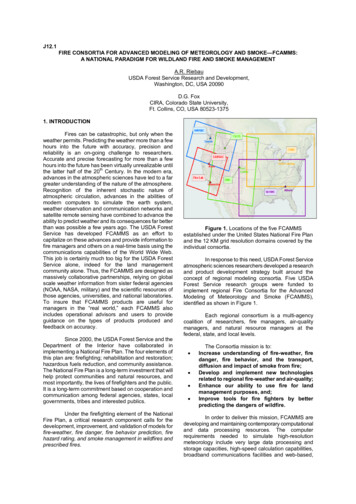
J12.1FIRE CONSORTIA FOR ADVANCED MODELING OF METEOROLOGY AND SMOKE—FCAMMS:A NATIONAL PARADIGM FOR WILDLAND FIRE AND SMOKE MANAGEMENTA.R. RiebauUSDA Forest Service Research and Development,Washington, DC, USA 20090D.G. FoxCIRA, Colorado State University,Ft. Collins, CO, USA 80523-13751. INTRODUCTIONFires can be catastrophic, but only when theweather permits. Predicting the weather more than a fewhours into the future with accuracy, precision andreliability is an on-going challenge to researchers.Accurate and precise forecasting for more than a fewhours into the future has been virtually unrealizable untilthe latter half of the 20th Century. In the modern era,advances in the atmospheric sciences have led to a fargreater understanding of the nature of the atmosphere.Recognition of the inherent stochastic nature ofatmospheric circulation, advances in the abilities ofmodern computers to simulate the earth system,weather observation and communication networks andsatellite remote sensing have combined to advance theability to predict weather and its consequences far betterthan was possible a few years ago. The USDA ForestService has developed FCAMMS as an effort tocapitalize on these advances and provide information tofire managers and others on a real-time basis using thecommunications capabilities of the World Wide Web.This job is certainly much too big for the USDA ForestService alone, indeed for the land managementcommunity alone. Thus, the FCAMMS are designed asmassively collaborative partnerships, relying on globalscale weather information from sister federal agencies(NOAA, NASA, military) and the scientific resources ofthose agencies, universities, and national laboratories.To insure that FCAMMS products are useful formanagers in the “real world,” each FCAMMS alsoincludes operational advisors and users to provideguidance on the types of products produced andfeedback on accuracy.Since 2000, the USDA Forest Service and theDepartment of the Interior have collaborated inimplementing a National Fire Plan. The four elements ofthis plan are: firefighting; rehabilitation and restoration;hazardous fuels reduction, and community assistance.The National Fire Plan is a long-term investment that willhelp protect communities and natural resources, andmost importantly, the lives of firefighters and the public.It is a long-term commitment based on cooperation andcommunication among federal agencies, states, localgovernments, tribes and interested publics.Under the firefighting element of the NationalFire Plan, a critical research component calls for thedevelopment, improvement, and validation of models forfire-weather, fire danger, fire behavior prediction, firehazard rating, and smoke management in wildfires andprescribed fires.Figure 1. Locations of the five FCAMMSestablished under the United States National Fire Planand the 12 KM grid resolution domains covered by theindividual consortia.In response to this need, USDA Forest Serviceatmospheric sciences researchers developed a researchand product development strategy built around theconcept of regional modeling consortia. Five USDAForest Service research groups were funded toimplement regional Fire Consortia for the AdvancedModeling of Meteorology and Smoke (FCAMMS),identified as shown in Figure 1.Each regional consortium is a multi-agencycoalition of researchers, fire managers, air-qualitymanagers, and natural resource managers at thefederal, state, and local levels. The Consortia mission is to:Increase understanding of fire-weather, firedanger, fire behavior, and the transport,diffusion and impact of smoke from fire;Develop and implement new technologiesrelated to regional fire-weather and air-quality;Enhance our ability to use fire for landmanagement purposes, and;Improve tools for fire fighters by betterpredicting the dangers of wildfire.In order to deliver this mission, FCAMMS aredeveloping and maintaining contemporary computationaland data processing resources. The computerrequirements needed to simulate high-resolutionmeteorology include very large data processing andstorage capacities, high-speed calculation capabilities,broadband communications facilities and web-based,
map-based graphical displays. In general, thesecapabilities are being provided through the use ofclusters of multiple PC processors operating underLINUX systems, utilizing large RAID disk array datastores and relying on the World Wide Web forcommunication. To a large extent these represent newand different ways for USDA Forest Service to dobusiness. FCAMMS have also led to significantimprovements in the internal capacity of the USDAForest Service Research and Development hiringscientists and technicians with modern computer andatmospheric sciences skills.2. THE CONSORTIUM APPROACHFCAMMS are developing as consortia for anumber of reasons. First, for the USDA Forest Serviceto credibly conduct contemporary atmospheric sciencesresearch, partnerships and resource sharing arenecessary. The wide array of skills needed toaccomplish the FCAMMS mission as well as the veryhigh cost of facilities and tools suggest a partnershipapproach. Second, the USDA Forest Service cannotmaintain a competitive position doing the sort ofresearch “on its own” because of its limited number ofresearch meteorologists. Third, there are othersavailable for partnerships that represent expertise andcapabilities well beyond any that the Forest Servicemight ever hope to develop or maintain.For example, simply generating the informationrequired to simulate high-resolution, real-timemeteorology requires: access to data generated by global-scale weatherforecast models run by sister federal agencies,international institutions, universities, the U.S.military and others; a capability to ingest these model data andsimulate timely, higher-resolution, realisticregional meteorology; a capability to understand, analyze, and comparewith ground based and satellite observations, critique, verify, and improve these regionalmeteorological simulations, and;a capability to ingest fire activity data and use itwith the meteorological simulations to estimatesmoke emissions, transport, transformation,dispersion and removal.Land managers are not likely to do this alonebecause they often lack needed access to satelliteobservations and forecast model data. The requiredskills, communications capacities, and researchcapabilities are well beyond land manager norms.Meanwhile, others especially universities, governmentagencies including the military, National Aeronautics andSpace Administration (NASA), National Oceanic andAtmospheric Administration (NOAA) and theEnvironmental Protection Administration (EPA), are onthe cutting-edge of developing the technologies andcapabilities required. Finally, the expense andcomplexity of this job is well beyond the capability ofland management budgets. Hence, the consortiumapproach, taking advantage of expertise in otheragencies and universities is the only approach thatmakes sense.In developing the FCAMMS concept theNorthwest Regional Modeling Consortium provided anexcellent model for the type of collaboration andcooperation required. This group, under the intellectualleadership of Professor Cliff Mass in the AtmosphericSciences Department at the University of Washingtonand a host of others in applied agencies, has pioneeredin the application and evaluation of regional scaleweather intelligence for a variety of applications,including those related to the interests of the FCAMMS.Following the Northwest model, the FCAMMS haveestablished and continue to seek a wide variety ofresearch and technology transfer partnerships withnumerous federal, state, and local agencies and privateorganizations (see Table 1).
Table 1. FCAMMS current members and partners with model run information.FCAMMSMembers and PartnersFrequencyEastern Area ModelingConsortium(EAMC)USDA Forest Service, North CentralResearchStation,NortheasternResearch Station, USDA ForestService Region 9 Aviation and FireManagement and Air ResourcesManagement Program, NortheasternArea State & Private Forestry, EasternArea Geographic Coordination Center,North Carolina State University,University of Utah, Jackson StateUniversity, University of Wisconsin,NOAA Air Resources LaboratoryNational Weather Service, Universityof Washington, Washington StateUniversity, USDA Forest ServicePacific Northwest research Station,Port of Seattle, United States tateDepartment of Ecology, Puget SoundClean Air Agency, Washington StateDepartment of Natural Resources,Washington State Department ofTransportation, Seattle City LightTwice-dailyEast Lansing, Michiganhttp://www.ncrs.fs.fed.us/eamcNorthwest RegionalModeling Consortium(NWRMC)Seattle, Washingtonhttp://www.atmos.washington.edu/pnw environ/Southern HighResolution ModelingConsortium(SHRMC)Athens, Georgiahttp://shrmc.ggy.uga.edu/California and NevadaSmoke and AirConsortium (CANSAC)Reno, Nevada andRiverside, Californiahttp://www.fs.fed.us/fcammsRocky MountainModeling Consortium(RMC)Fort Collins, Coloradohttp://www.fs.fed.us/rmcRunTime8hrModel DomainGrid Spacing36km, 12km,4km(1 Km plannedover New Jersey)Twice-daily72hr48hr36km, 12km,4kmUniversity of Georgia, GeorgiaForestry Commission, USDA ForestService Region 8, USDA ForestService Southern Research Station,National Weather Service4 times daily48hr36km, 12kmDesert Research Institute, Universityof Nevada, University of California –Santa Barbara, University of California– San Diego, Maui High PerformanceComputer Center, Naval PostgraduateSchool, Scripps Institute, USDAForest Service Pacific SouthwestResearch StationUSDA Forest Service Air ResourcesProgram, NOAA Forecast SystemsLaboratory, Rocky Mountain AreaGeographic Coordinating Center,SouthwestAreaGeographicCoordinating Center, USDA ForestService Rocky Mountain 6,4,2km48hr108,36,12k48hr27,9,3,1km24hr12km, 4km (as ofMar 2003)4 times daily
Each FCAMMS is developing different andunique cooperative relationships; however, there are afew common elements in these. NOAA is, of course, thesource of data and model initialization fields for theFCAMMS simulations. As well, satellite observationsand climate data from NESDIS are critical for theFCAMMS research. It is important to note that NOAAmaintains the lead responsibility for forecasting weatherin general and fire weather in particular. NOAAmeteorologists utilize a wide array of weatherintelligence in this role and interact directly with the firecommunity. In no way do the FCAMMS affect thisrelationship. Rather the FCAMMS high-resolutionresearch oriented information is intended to supplementthe NOAA work with a focus on fire, forestry, and smokeapplications. NASA also provides critical partnershipswith the FCAMMS by providing MODIS data that isbeing interpreted at the USDA Forest Service MissoulaFire Laboratory to provide critical fire activity, locationand emissions information. Various agencies in the U.S.Department of the Interior represent critical partnershipsfor both providing data and utilizing FCAMMSintelligence, especially within the wildland firecommunity. Finally, as the list in Table 1 showsuniversities are key partners providing intellectual aswell as logistical support and students for the FCAMMS.3.1 Fire weather and fire management applicationsEach consortium conducts basic and appliedresearch on new fire-weather and fire-climate indexdevelopment, seasonal fire severity, small-scale fireatmosphere interaction dynamics, smoke emissions,transport and diffusion, and coupled fire-atmospheremodeling. In support of these research goals, eachregional consortium produces daily, regional nsport/diffusion variables using a common set ofmodeling tools (e.g., the MM5 mesoscale meteorologicalmodel, Grell et al. 1994) over the domains as shown inFigure 1. Individual consortium web sites make thisinformation available to the user community on a dailybasis. Users are provided a variety of map products andanalyses depicting the current and 24-48 houratmospheric conditions relevant for fire-weather, firebehavior, and smoke transport and diffusion. All theconsortia are committed to improving their products byfeedback from their user communities and fieldverification studies. Table 1 also provides a summary ofthe FCAMMS simulations and websites.Unfortunately, roles for both informationproviders and users, including state air qualityregulators, are not as well identified for applications inair quality and smoke management. First, air quality isnot an area where the USDA Forest Service has anatural or clearly defined role. Internally, it is difficult formanagers to accept that this is work that the ForestService needs to do. Research in air quality is not atraditional arena for the Forest Service; however, boththe Forest Service and the National Park Service havemaintained significant efforts in research on visibility andair quality effects on pristine areas since 1977 when theClean Air Act mandated a role for them to protect the airquality related values of these areas. This role led bothagencies to undertake work on air quality modeling bothfor industrial sources that might impact federal Parksand Wildernesses as well as for smoke from forestburning.3. FCAMMS CONCEPTUAL STRUCTUREThe ideal FCAMMS is structured around asmall ‘inner core’ group of scientists and technicianswho run high-resolution meteorological simulationmodels, such as MM5 and similar ancillary models andwho make results available to others (scientists). Arelatively larger group of specialists take data from the‘inner ring’ and combine it with other data, other types ofmodel simulations, and observational data to produceinformation and information based products for agencies(information suppliers). In the ideal case, the largestcomponent (‘outer ring’) of the FCAMMS is populated byindividuals and agencies that use the information(users). Ideally, the users will provide feedback,guidance, funding, and help in identifying problems forscientists and information providers.Within the fire management community it ispossible for the FCAMMS to implement this sort ofidealized structure, especially as it is applied to firefighting. For the fire fighting community, there is a welldeveloped infrastructure of people and resources. USDAForest Service’s Research and Developmentorganization funds FCAMMS and provides other supportfor the ‘inner core’ scientists and technicians. At theindividual FCAMMS the ‘inner core’ is mostly ForestService scientists and technicians working incooperation with university scientists and students. The‘information suppliers’ for the fire managementcommunity are represented by both the NationalInteragency Coordination Center (NIFC) and thepredictive services of the Geographic Area CoordinationCenters (GACCS). These groups consist ofmeteorologists and trained fire specialists who arecapable of using the high-resolution outputs of weatherand fire intelligence products to assist them in providingtheir user communities the sorts of information theyneed. Finally, the fire management community as awhole is the user for these products.3.2 Smoke and air quality applicationsNevertheless, the roles of the federal landmanagers in air quality modeling are somewhatconfused. In this case, the users as well as theinformation providers represent a much broader group ofpeople. They range from regulatory personnel at variousgovernmental levels, to private sector land managers, tomembers of the general public. Each user has asomewhat distinct set of requirements and a differentlevel of understanding and capability of assimilating theweather and air quality intelligence provided by theFCAMMS. In order for the FCAMMS to be successful inproviding smoke management and other air qualityproducts each FCAMMS will need to identify anddevelop close working relationships with both theinformation provider and user level of partners.Dr. Sue Ferguson at the Northwest FCAMMSis leading the way developing appropriate workingrelationships between the regional modelers, the firecommunity, and the air quality community. The BlueSkymodel framework has been developed to support this
relationship and FCAMMS around the country areplanning on implementing it as soon as it is available. Inaddition to BlueSky, the FCAMMS will also need todevelop partnerships with the various Regional PlanningOrganizations around the country. RPOs are currentlydeveloping procedures for conducting regional air qualitymodeling for planning purposes. In general, thesemodels are all driven by simulated meteorology fromMM5 and similar meteorological models. Hence, there isa clear opportunity for FCAMMS to become involved.However, for the RPOs, regional scale meteorology is arelatively easy component of their work. The moredifficult aspects of the RPO job are developing andmanaging emissions inventories and the results ofcomplex regional scale atmospheric chemistry,transport, dispersion and deposition models. Theemissions inventory work, especially as it applies to firesources, is another area where the FCAMMS might beable to provide assistance.the eastern U.S. Figure 3, from the Southern HighResolution Modeling Consortium, illustrates a 48 hourforecast providing intelligence about possible future windand moisture conditions.4. FCAMMS PRODUCTS4.1 High-resolution weather variablesAll of the consortia provide a range of weatherproducts simulated using the MM5 model on gridresolutions of 36 km and better. Figure 2, from theEastern Area Modeling Consortium, illustrates a 24-hourforecast of the surface wind vector for the 12 km grid forFigure 2. EMAC map of 10-meter Wind (meters/sec) at12km resolution initialized at 0000 August 29, 2003, 24hours after model initialization.Figure 3. Illustration of forecasts from the 12 km resolution MM5 simulation by the Southern High ResolutionModeling Center (SHRMC) of surface relative humidity, wind vectors, and surface pressure initiated at 12z,August 28 for 24 and 48 hours ahead.
4.2 High-resolution fire indicesFigure 4 from the Northwest Regional ModelingConsortium MM5 simulations illustrates the changeover time in the pattern of the forecasted HainesIndex. The Haines Index is a simple measure of thechance that an existing fire will become a dangerous,erratic fire. It reflects atmospheric stability andmoisture in a layer of the atmosphere roughly 1 to 5km above the surface. High values indicate higher risk ofdangerous fire behavior (Haines, 1988). Figure 5, from theRocky Mountain Modeling Consortium’s southwesternwindow, illustrate the forecast changes on a 4 kmresolution of the Fosberg Fire Weather Index. The FosbergIndex is a measure that reflects expected flame length andfuel drying based on wind speed, temperature andhumidity. High values indicate high flame lengths andrapid drying (Fosberg, 1978).Figure 4. Illustration of the forecast Haines index, initialized at 00z 19 August, 24 hours into the forecast and thesame after 48 hours based on a 12 km resolution MM5 simulation from the Northwest Regional ModelingConsortium (NWRMC).Figure 5. Illustration of Fosberg Fire Weather Index (red highest value) predicted from the Rocky Mountain ModelingCenter’s 4 km MM5 simulation over Arizona and New. Mexico.
Figure 6. California Fire Weather Index (red as highest index value), produced by the California Smoke and AirConsortium in collaboration with Scripts Institute. The forecast is for 7days, illustrated as a 24-hour forecast at17:00 August 18 and 168 hour forecast at 17:00 for August 24.Figure 6 illustrates the California Fire Weatherindex, a variant of the Fosberg Fire Weather Index. Thisindex results from combining wind, temperature, andhumidity information as used by the National FireDanger Rating Program (NFDR; Deeming, et.al. 1977).In essence, the CFWI suggests where it will be hot, dryand windy, hence increasing the likelihood of fires. Thecolor-coding goes from low values in green towardhigher values in red. Figure 6 illustrates a 7-day forecastdone by the CANSC at the USDA FS Riverside FireLaboratory and University of California at San Diego,Scripps Institute of Oceanography's ExperimentalClimate Prediction Center. The figure illustrates thevalue of longer range, higher-grid resolution modelinformation for fire fighters4.3 Smoke Dispersion ProductsA major application and justification for theFCAMMS is providing intelligence for managing smokefrom forest burning. Smoke management has strategicplanning, tactical planning and operational aspects to it.4.3.1 Strategic planningStrategic planning applications are needed toassess wildfire and prescribed fire impacts on regionaland local air quality. The Clean Air Act requires Statesand Tribes to maintain the National Ambient AirQuality Standards (NAAQS) for a set of “criteriapollutants” that include NOx, CO, Ozone and PM.There are additional regulatory requirements forStates and Tribes to return visibility to its ‘naturalcondition’ at 153 ‘Class 1’ areas (National Parks andwilderness areas) through out the US. Both of theserequirements involve States and Tribes developingand promulgating so called State (Tribal)Implementation Plans, or S/TIPs.Figure 7. Aerosol data showing the percentagecontribution to visibility impairment of organic aerosolillustrating that fire sources may be a significantinfluence on western US visibility.http://vista.colostate.edu/viewsFigure 7, shows data from the IMPROVEmonitoring network that suggests significant visibilityimpairment may be attributed to organic air pollutionsources in the western, especially the northwestern,U.S. While it is understood that smoke from wildfire is anatural condition, it is also clear that the firemanagement community, at the very least, must quantifypollutant inputs to the air shed resulting from wildfire,prescribed fire and agricultural burning. The S/TIPprocess is one that increasingly requires the use ofsophisticated, multiple-pollutant, atmospheric chemistrysimulation models, such as CMAQ and REMSAD. Forthe land management community to play a significantrole in developing the S/TIPs and in the negotiation ofemissions limitations that is their ultimate purpose,FCAMMS will need to include regional air qualitymodeling in their activities. To date, this remains an areathat will be considered in the future. However, asignificant advantage of the collaboration that is inherentin the FCAMMS is that regional air quality modelers willbe welcome as partners and will find much of the dataand computational resources they require availablethrough the FCAMMS.A critical need from the fire management
community for both the strategic planning discussedhere and the tactical planning and operations discussedin the next section is quantification of fire activity and theassociated emissions that result from that fire activity.(Battye and Battye, 2002; Sestak, et. al., 2002).Figure 8. A MODIS image of the western UnitedStates taken on 28 August illustrating hot spots.Details at http://www.firelab.org/rsl/.Although not strictly an FCAMMS, neverthelessa very closely associated activity is the research beingconducted at the USDA Forest Service Missoula FireLaboratory on utilizing the MODIS instrument on theTERRA and AQUA satellite platforms to identify fireboundaries and emissions. Figure 8 illustrates a recentscenefromthenewfireboundaryalgorithm developed by Dr. WeiMin Hao and his team ofresearchers.4.3.2 Tactical Planning & OperationsTactical planning and operational applications, both aneed a smoke management tool that provides anindication of where smoke is likely to go once a fire isignited allowing real-time forecasts of smoke impactsfrom individual and groups of potential and actual fires.For this purpose the FCAMMS are in the process ofimplementing the BlueSky modeling framework. TheBlueSky smoke-modeling framework, developed by Dr.Sue Ferguson and her team of scientists at the FSSeattle fire laboratory, is a flexible framework forobtaining smoke impacts by combining fire locationinformation, forest fuels, outputs from MM5meteorological simulations and air quality dispersionmodels (e.g., the CALPUFF) to illustrate where smokewill go and how much of it will get there. The NWRMC iscooperating with the U.S. EPA to prototype theBlueSky/RAINS program. BlueSky/RAINS links theBlueSky smoke-modeling framework with the RapidAccess INformation System (RAINS) based web servingtechnology. RAINS utilizes the ArcIMS / geographicinformation system (GIS) to allow for data overlays froma variety of geographical data. BlueSky/RAINS iscurrently being tested in the U.S. Pacific Northwest.Figure 9 illustrates some of the capability of theBlueSky/RAINS system to provide information about thelikely trajectories and ground level concentration impactsfrom prescribed fire activity. The GIS provides greatflexibility displaying the results.Figure 9. Wildfire smoke trajectories and concentrations as illustrated by the BlueSky/RAINS (NWRMC) system forprescribed fire activity on June3, 2003.
5. CONCLUSIONS AND NEXT STEPSContinuing issues associated with theFCAMMS include solidifying each consortium includingits participants (through formal agreements), funding,and projects. FCAMMS must also be provided a nationaloverlay to the regional activities of each consortium.Each consortium has grown naturally, based on theinterests and capabilities of the scientists and managersinvolved in its development. While this spirit willcontinue, there remains a need for nationally commonproducts.The BlueSky framework represents asignificant step forward in dealing with smoke emissions,and the FCAMMS plan to implement it in eachconsortium. However, there are challenges in doing this.One is a concern for how to provide data on firelocations and fire emissions for the system nationally.Secondly, there is a need to add additional dispersionmodeling capabilities to the BlueSky framework, tobroaden its applicability for strategic planning. Forexample, applications, such as Clean Air Act requiredstate implementation plans (SIPs), require a specializedinventory of fire data including the date, duration, andlocation of all major wild and planned fires along with anaccurate estimate of emissions and plume rise fromsuch fires. SIPs also require hourly estimates ofemissions for a “typical” year, detailed chemicalcharacterization of the emissions for the purpose ofdriving regional air chemistry models and an ability to“game” the emissions for future years. “Gaming” mightinclude tradeoffs between prescribed and wildfire, aswell as alternative locations for fire and the potential fordrought and major fire activity. Tactical planning mightrequire more accurate, precise, and detailed informationabout the location and nature of the planned burning.Operational activities will need real-time information, notsimply what is planned but what has actually beenignited, for which ground-observations, aircraft overflight information, and remote sensing will need to beintelligently combined with mesoscale meteorology anddispersion model simulations.6. REFERENCESBattye, W. and R. Battye 2002. Development ofEmissions Inventory Methods for Wildland Fire. FinalReport. Prepared for: Thompson G. Pace, U.S.Environmental Protection Agency EPA Contract No. 68D-98-046. Prepared by EC/R Incorporated. 91 pp.Burgan, R.E. and R. A. Hartford, 1993.Monitoring Vegetation Greenness with Satellite Data.United States Department of Agriculture, Forest Service,General Technical Report INT-297, IntermountainForest and Range Experiment Station, Ogden, Utah. 13pp.Deeming, John E., R.E. Burgan, and J. D.Cohen, 1977. The National Fire-Danger Rating System- 1978. Gen. Tech. Rep. INT-39. Ogden, UT: ntain Forest and Range Experiment Station. 63pp.Fosberg, M.A. 1978. Weather in wildland firemanagement: the fire weather index. Proceedings of theConference on Sierra Nevada Meteorology, South LakeTahoe, pp 1- 4.Grell, G. A., J. Duhia, and D.R. Stauffer, 1994.A Description of the Fifth Generation Penn-State./NCARMesoscale Meteorological Model (MM5). NCARTechnical Note NCAR/TN – 398 STR. 138 pp.Haines, D.A. 1988. A lower atmosphericseverity index for wildland fire. National Weather Digest.Vol 13. No. 2:23-27.Sestak M.L., S. O’Neill, S. Ferguson, J. Ching,and D. Fox. 2002. Integration of Wildfire Emissions intoModels-3/CMAQ with the Prototypes: CommunitySmoke Emissions Modeling System (CSEM) andBlueSky. CMAS Conference Extended Abstracts. U.S.EPA, Research Triangle Park, North Carolina, USA. 6pp.
USDA Forest Service, North Central Research Station, Northeastern Research Station, USDA Forest . Seattle City Light Twice-daily 72hr 48hr 36km, 12km, 4km Southern High Resolution Modeling . Coordinating Center, USDA Forest Service Roc